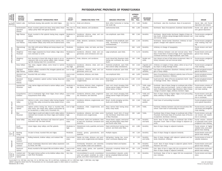
ATLANTIC COASTAL PLAIN PIEDMONT NEW ENGLAND RIDGE AND VALLEY APPALACHIAN PLATEAUS CENPHYSIOTRAL LOW- GRAPHIC LANDS PROVINCE PHYSIOGRAPHIC PROVINCES OF PENNSYLVANIA PHYSIOGRAPHIC SECTION DOMINANT TOPOGRAPHIC FORM LOCAL RELIEF1 UNDERLYING ROCK TYPE GEOLOGIC STRUCTURE APPROXIMATE ELEVATION2 Min. Max. DRAINAGE PATTERN BOUNDARIES ORIGIN Eastern Lake Northwest-sloping, lake-parallel, low-relief ridges. Very low to low. Shale and siltstone. Beds either horizontal or having low south dip. 570 1,000 Parallel. Northwest: Lake Erie. Southeast: Base of escarpment. Glacial, lake, and fluvial deposition and erosion. Northwestern Glaciated Plateau Broad, rounded upland and deep, steep-sided, linear valleys partly filled with glacial deposits. Very low to moderate. Shale, siltstone, and sandstone. Subhorizontal beds. 900 2,200 Dendritic. Northwest: Base of escarpment. Southeast: Glacial border. Fluvial and glacial erosion; glacial deposition. High Plateau Broad, rounded to flat uplands having deep, angular valleys. Moderate to high. Sandstone, siltstone, shale, and conglomerate; some coal. Low-amplitude, open folds. 980 2,360 Dendritic. Northwest: Glacial border. Northeast: Margins of deep valleys. South: Arbitrary along drainage divides between coal and noncoal areas. Fluvial erosion; periglacial mass wasting. Pittsburgh Low Plateau Smooth to irregular, undulating surface; narrow, relatively shallow valleys; strip mines and reclaimed land. Low to moderate. Shale, siltstone, sandstone, limestone, and coal. Moderate- to low-amplitude, open folds, decreasing in occurrence northwestward. 660 2,340 Dendritic. Northwest: Glacial border. Elsewhere: Arbitrary at topographic changes with adjacent sections. Fluvial erosion; periglacial mass wasting; strip mining. Waynesburg Hills Very hilly with narrow hilltops and steep-sloped, narrow valleys. Moderate. Sandstone, shale, red beds, and limestone. Horizontal beds. 848 1,638 Dendritic. Arbitrary at change of topography. Fluvial erosion and landslides. Allegheny Mountain Wide ridges separated by broad valleys; ridge elevations decrease to north. Moderate to high. Sandstone, siltstone, shale, and conglomerate; some limestone and coal. Large-amplitude, open folds. 775 3,210 Dendritic. East: Arbitrary between coal and noncoal areas. West: Base of west flank of Chestnut Ridge. North: Approximates northeast terminus of large-amplitude, open folds. Fluvial erosion; some periglacial mass wasting. Allegheny Front East: Rounded to linear hills rising by steps to an escarpment; hills cut by narrow valleys. West: Undulating hills sloping away from escarpment. Moderate to high. Shale, siltstone, and sandstone. South: Broad fold. Elsewhere: Beds having low northwest dip; some faults. 540 2,980 Parallel and trellis. East: Stream at base of hills below escarpment. West: Arbitrary between coal and noncoal areas. Fluvial erosion; periglacial mass wasting. Deep Valleys Very deep, angular valleys; some broad to narrow uplands. Moderate to very high. Sandstone, siltstone, shale, and conglomerate. Moderate-amplitude, open folds that control valley orientations. 560 2,560 Angulate and rectangular. Arbitrary at margins of deep valleys, either at top of valley slope or along drainage divide. Fluvial erosion; periglacial mass wasting. Glaciated High Plateau Broad to narrow, rounded to flat, elongate uplands and shallow valleys. Low to high. Sandstone, siltstone, shale, and conglomerate; some coal. Moderate-amplitude, open folds. 620 2,560 Angulate and dendritic. East: Base of escarpment. Elsewhere: Arbitrary with margins of deep valleys. Fluvial and glacial erosion; glacial deposition. Glaciated Low Plateau Rounded hills and valleys. Low to moderate. Sandstone, siltstone, and shale. Low-amplitude folds. 440 2,690 Dendritic. Base of escarpments of adjacent uplands; base of Pocono escarpment. Elsewhere: Arbitrary. Fluvial and glacial erosion; glacial deposition. Glaciated Pocono Plateau Broad, undulatory upland surface having dissected margins. Low to moderate. Sandstone, siltstone, and shale; some conglomerate. Beds having low north dip; some small folds. 1,200 2.320 Deranged. South and east: Base of Pocono escarpment. North: Crest of drainage divide. West: Arbitrary. Fluvial and glacial erosion; glacial deposition. Appalachian Mountain Long, narrow ridges and broad to narrow valleys; some karst. Moderate to very high. Sandstone, siltstone, shale, conglomerate, limestone, and dolomite. Open and closed plunging folds having narrow hinges and planar limbs; variety of faults. 440 2,775 Trellis, angulate, and some karst. Southeast: Base of slope change on southeast side of Blue Mountain. West and northwest: Center of valley bottom west of westernmost linear ridge. Elsewhere: Base of slope change of eastern ridges; arbitrary between ridges. Fluvial erosion; solution of carbonate rocks; periglacial mass wasting. Susquehanna Lowland Low to moderately high, linear ridges; linear valleys; Susquehanna River valley. Low to moderate. Sandstone, siltstone, shale, conglomerate, limestone, and dolomite. Open and closed plunging folds having narrow hinges and planar limbs. 260 1,715 Trellis and angulate. Base of slope change to higher ridges of all surrounding areas; arbitrary in valley areas. Fluvial erosion; some glacial erosion and deposition in northeast. Anthracite Valley Narrow to wide, canoe-shaped valley having irregular to linear hills; valley enclosed by steep-sloped mountain rim. Low to moderate. Sandstone, siltstone, conglomerate, and anthracite. Broad, doubly-plunging syncline; faults and smaller folds. 500 2,368 Trellis and parallel. Outer base of surrounding mountain. Fluvial and glacial erosion; some glacial deposition. Anthracite Upland Upland surface having low, linear to rounded hills, strip mines, and waste piles; upland surrounded by an escarpment, a valley, and a mountain rim. Low to high. Sandstone, shale, conglomerate, and anthracite. Many narrow folds having steep limbs; many faults. 320 2,094 Trellis. Northeast: Arbitrary between coal and noncoal areas. Elsewhere: Outer base of surrounding mountain. Fluvial erosion; some glacial erosion and periglacial mass wasting. Blue Mountain Linear ridge to south and valley to north; valley widens eastward and includes low linear ridges and shallow valleys. Moderate to high. Sandstone, siltstone, and shale; some limestone and conglomerate. Southwest: South limb of broad fold. Northeast: Small folds north of Blue Mountain. 300 1,680 Trellis. Southeast: Base of slope change on southeast side of Blue Mountain. Northwest: Base of mountain; base of Pocono escarpment. Northeast: Arbitrary. Fluvial erosion; some glacial erosion and deposition in northeast. Great Valley Very broad valley. Northwest half: Dissected upland. Southeast half: Low karst terrain. Low to moderate. Northwest: Shale and sandstone; slate at east end. Southeast: Limestone and dolomite. Thrust sheets, nappes, overturned folds, and steep faults; many thirdand fourth-order folds. 140 1,100 Dendritic and karst. North: Base of slope change on southeast side of Blue Mountain. South: Base of slope change to adjacent uplands. Fluvial erosion; solution of carbonate rocks; some periglacial mass wasting. South Mountain Linear ridges, deep valleys, and flat uplands. Moderate to high. Metavolcanic rocks, quartzite, and some dolomite. Major anticlinorium having many second- and third-order folds. 450 2,080 Dendritic. Base of slope change to adjacent lowlands. Fluvial erosion of highly variable rocks; some periglacial mass wasting. Reading Prong Circular to linear, rounded hills and ridges. Moderate. Granitic gneiss, granodiorite, and quartzite. Multiple nappes. 140 1,364 Dendritic. Base of slope change to adjacent lowlands. Fluvial erosion; some periglacial mass wasting. GettysburgNewark Lowland Rolling lowlands, shallow valleys, and isolated hills. Low to moderate. Mainly red shale, siltstone, and sandstone; some conglomerate and diabase. Half-graben having low, monoclinal, northwest-dipping beds. 20 1,355 Dendritic and trellis. Base of slope changes with adjacent uplands and lowlands. Elsewhere: Arbitrary. Fluvial erosion of rocks of variable resistance. Piedmont Lowland Broad, moderately dissected, karst valleys separated by broad, low hills. Low. Dominantly limestone and dolomite; some phyllitic shale and sandstone. Complexly folded and faulted. 60 700 Dendritic and karst. South: Base of slope change to adjacent upland. North: Mesozoic red rocks. Fluvial erosion; some periglacial mass wasting. Piedmont Upland Broad, rounded to flat-topped hills and shallow valleys. Low to moderate. Mainly schist, gneiss, and quartzite; some saprolite. Extremely complexly folded and faulted. 100 1,220 Dendritic. East: Base of low to vague Fall Line escarpment. North: Base of slope change to adjacent lowlands. Fluvial erosion; some periglacial mass wasting. Lowland and Intermediate Upland Flat upper terrace surface cut by shallow valleys; Delaware River floodplain. Very low. Unconsolidated to poorly consolidated sand and gravel; underlain by schist, gneiss, and other metamorphic rocks. Unconsolidated deposits underlain by complexly folded and faulted rocks. 0 200 Dendritic. Northwest: Base of low to vague Fall Line escarpment. East: Arbitrary. Fluvial erosion and deposition. 1 Local relief: 0 to 100 feet, very low; 101 to 300 feet, low; 301 to 600 feet, moderate; 601 to 1,000 feet, high; >1,000 feet, very high. (Relief categories listed here for Pennsylvania do not necessarily apply to other states or countries.) Elevations are in feet. 2 2200–MP–DCNR0382 Printed on Recycled Paper.
