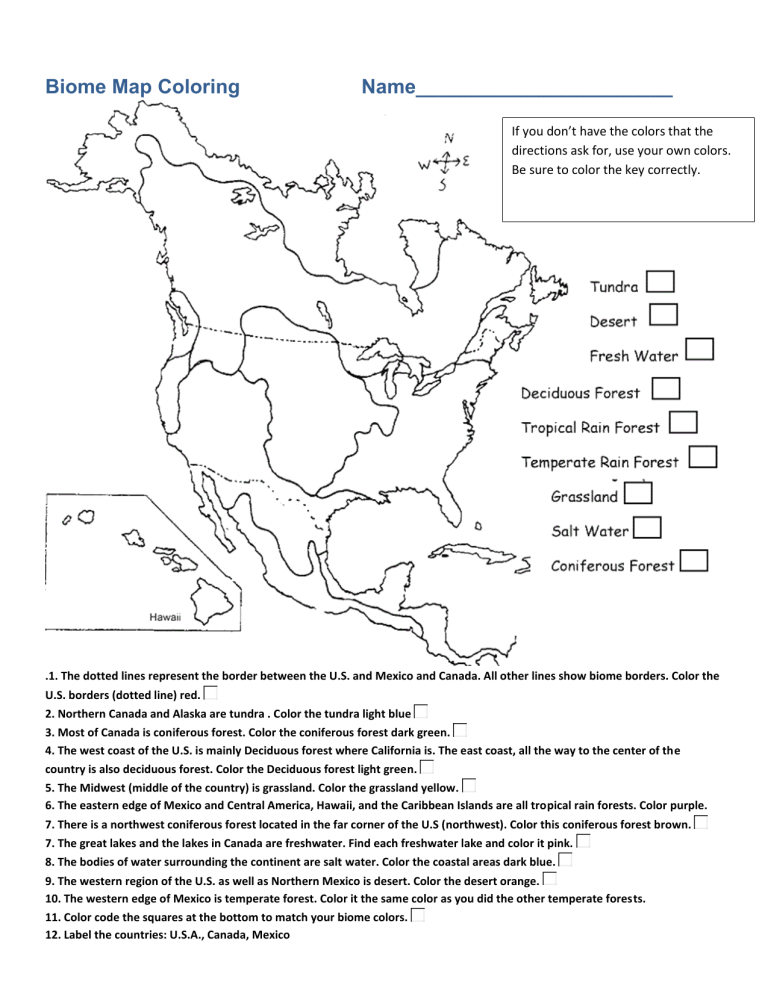
Biome Map Coloring Name_______________________ If you don’t have the colors that the directions ask for, use your own colors. Be sure to color the key correctly. .1. The dotted lines represent the border between the U.S. and Mexico and Canada. All other lines show biome borders. Color the U.S. borders (dotted line) red. 2. Northern Canada and Alaska are tundra . Color the tundra light blue 3. Most of Canada is coniferous forest. Color the coniferous forest dark green. 4. The west coast of the U.S. is mainly Deciduous forest where California is. The east coast, all the way to the center of the country is also deciduous forest. Color the Deciduous forest light green. 5. The Midwest (middle of the country) is grassland. Color the grassland yellow. 6. The eastern edge of Mexico and Central America, Hawaii, and the Caribbean Islands are all tropical rain forests. Color purple. 7. There is a northwest coniferous forest located in the far corner of the U.S (northwest). Color this coniferous forest brown. 7. The great lakes and the lakes in Canada are freshwater. Find each freshwater lake and color it pink. 8. The bodies of water surrounding the continent are salt water. Color the coastal areas dark blue. 9. The western region of the U.S. as well as Northern Mexico is desert. Color the desert orange. 10. The western edge of Mexico is temperate forest. Color it the same color as you did the other temperate forests. 11. Color code the squares at the bottom to match your biome colors. 12. Label the countries: U.S.A., Canada, Mexico Questions 1. Name the 3 main biomes of the United States (land only).____________________________ 2. What two biomes are closest to where you live? __________________________________ Place an X on the map to show your approximate location. 3. What U.S. state could a person visit a tropical rain forest in? _________________ How about a temperate rain forest? ______________________ 5. Point out Alaska by drawing an arrow to it. What biome is found in Alaska? ____________ 6. If you traveled due north from your current location, what biomes would you pass through (just going to the north pole) ______________________________ 7. A person is driving from Los Angeles, California to Washington D.C. Name the biomes the person will pass through, in the correct order. ___________________________________ 8. A person is driving from Alaska to Mexico, staying close to the west coastline. Name the biomes the person will pass through, in the correct order. ___________________________ Publisher: Biologycorner.com; Biome Map KEY Original Worksheet: Biome Map Coloring Coloring can vary slightly, the divisions between biomes is not always clear. If students follow the directions carefully, their map should be colored like this: The Canadian border is often a problem spot, as students think it's a biome boundary instead of a country border. Questions 1. Name the 3 main biomes of the United States (land only).____grassland, deciduous forest, desert_____________ 2. What two biomes are closest to where you live? _________answers vary_________________________ Place an X on the map to show your approximate location. varies 3. What U.S. state could a person visit a tropical rain forest in? ______Hawaii___________ How about a temperate rain forest? ______Oregon or Washington, possibly northern California________________ 5. Point out Alaska by drawing an arrow to it. What biome is found in Alaska? _____tundra_______ 6. If you traveled due north from your current location, what biomes would you pass through (just going to the north pole) answers vary, from St Louis: deciduous forest, coniferous forest, tundra 7. A person is driving from Los Angeles, California to Washington D.C. Name the biomes the person will pass through, in the correct order. ________desert, grassland, temperate rain forest__ 8. A person is driving from Alaska to Mexico, staying close to the west coastline. Name the biomes the person will pass through, in the correct order. ____tundra, coniferous forest, temperate rain forest, deciduous forest, desert__
