Part-2-Chapter-4-Melbourne-West-Investigation-Area-Wyndham-Growth-Area-pages-29-to-37
advertisement

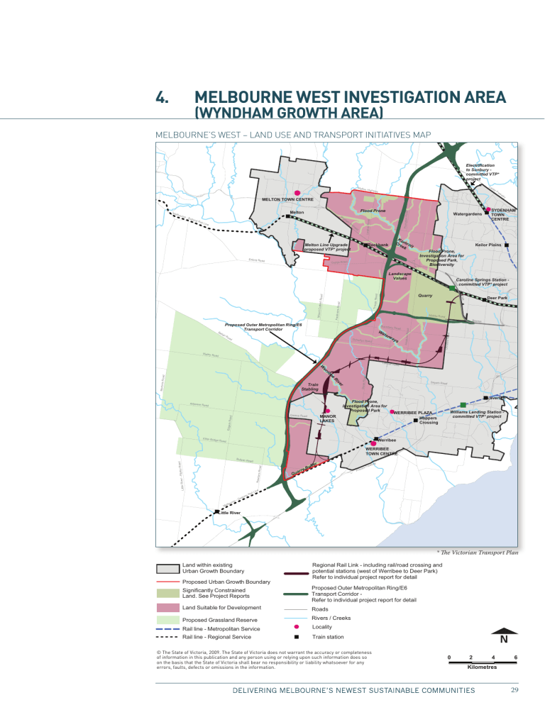
*$ C;B8EKHD;M;IJ?DL;IJ?=7J?ED7H;7 MOD:>7C=HEMJ>7H;7 B:A7DJGC:ÉHL:HIÄA6C9JH:6C9IG6CHEDGI>C>I>6I>K:HB6E Electrification to Sunbury committed VTP* project Melton Ca lde rF Highwa y re ew a MELTON TOWN CENTRE Flood Prone Melton W es il Lin e te rn Fr ee wa y Melton Line Upgrade proposed VTP* project Exford Ro ad Plumpton Roa d ourn e-B alla rat R a Leakes Road Melb Watergardens Ko Cr roro ee k it Rockbank y SYDENHAM TOWN CENTRE Keilor Plains Flood Prone, Investigation Area for Proposed Park, Biodiversity Greigs Road Landscape Values er De Caroline Springs Station committed VTP* project d Troups Roa Faulkners Road Dohertys Roa d Christies Roa d oa d Road Wa ter wa ys d Bypass Boundary Hopkins Roa Mount Cot trell Road Park Ripley Ro Deer Park Middle Roa d Proposed Outer Metropolitan Ring/E6 Transport Corridor Ba lla nR Quarry ad er iv R Mortons Roa d ee rib er W Train Stabling Sayers Roa Flood Prone, Investigation Area for Proposed Park Argoona Road MANOR LAKES Edgars Road Greens Road Kirks Bri dge Road Davis Road Leakes d Laverton WERRIBEE PLAZA Hoppers Crossing Williams Landing Station committed VTP* project Werribee Road WERRIBEE TOWN CENTRE ad Little River Newtons Road - Ripley Roa d Bulban Ro urn lbo Me G e- gR lon ee a Qu r ry Bu f fe r ce s Prin Fre a ew y e Lin ail Little River * The Victorian Transport Plan Land within existing Urban Growth Boundary Regional Rail Link - including rail/road crossing and potential stations (west of Werribee to Deer Park) Refer to individual project report for detail Proposed Urban Growth Boundary Significantly Constrained Land. See Project Reports Proposed Outer Metropolitan Ring/E6 Transport Corridor Refer to individual project report for detail Land Suitable for Development Roads Proposed Grassland Reserve Rivers / Creeks Rail line - Metropolitan Service Locality Rail line - Regional Service Train station 0 2 Ki (c) The State of Victoria, 2009. The State o the accuracy or completeness of informatio person using or relying upon such informat that the State of Victoria shall bear no resp whatsoever for any errors, faults, defects o I]ZHiViZd[K^Xidg^V!'%%.#I]ZHiViZd[K^Xidg^VYdZhcdilVggVcii]ZVXXjgVXndgXdbeaZiZcZhh d[^c[dgbVi^dc^ci]^hejWa^XVi^dcVcYVcneZghdcjh^c\dggZan^c\jedchjX]^c[dgbVi^dcYdZhhd dci]ZWVh^hi]Vii]ZHiViZd[K^Xidg^Vh]VaaWZVgcdgZhedch^W^a^indga^VW^a^inl]VihdZkZg[dgVcn Zggdgh![Vjaih!YZ[ZXihdgdb^hh^dch^ci]Z^c[dgbVi^dc# 0 2 4 6 Kilometres 29 )#& JC9:GHI6C9>C<I=:6G:6 The Wyndham growth area extension wraps around the west and south western boundaries of the existing Wyndham growth area and extends north to Boundary Road taking in the areas of Truganina, Tarneit and Mount Cottrell. Land use in this area is predominantly rural, with several quarries located towards the western boundary and intensive industries scattered throughout. Key natural and built features that have been considered in determining land suitable for development within this Investigation Area are described in this section. Background Technical Reports are available for further information. Biodiversity A significant constraint to development is the high quality native vegetation and related fauna scattered across this Investigation Area and in areas immediately outside it. Despite long term farming and urban development, this area contains some of the largest remnants of the nationally significant critically endangered Natural Temperate Grasslands of the Victorian Volcanic Plain within a largely cleared bio-region. Biodiversity studies in the Investigation Area and in the areas immediately outside it indicate the presence or potential presence of a number of flora species listed under the Environment Protection and Biodiversity Conservation Act, 1999. Although it does not fall within a declared Ramsar wetland, the northern extension of the Port Phillip Bay Ramsar area is close to the southern edge of the Investigation Area. Heritage There are two sites listed on the Register of the National Estate within the Wyndham Investigation Area – the Werribee River Burial Site and an historic place in the Werribee River Area in Exford. These sites can be retained and protected in preparing Precinct Structure Plans. There are no Commonwealth Heritage Places within the Investigation Area. Wildfire The Wyndham part of the West Investigation Area, comprises areas of grazing, cropping and native grasslands, with some small pockets of trees. 30 The areas of trees are small and scattered and not significant in relation to wildfire risk. However any development bordering native vegetation, trees or grassland is at some risk from wildfire. The presence of grassland areas and scattered trees indicates that consideration needs to be given to wildfire protection when preparing Precinct Structure Plans and designing developments. Werribee River and its tributaries The Werribee River and a number of smaller waterways, such as Dry Creek and Skeleton Creek, transect the Investigation Area. These drainage corridors present both a constraint and opportunity for future urban development. They are a constraint in terms of flooding, waterway management and the need for future bridging for new roads and rail. They provide an opportunity as environmental and recreational assets for the region that create a sense of place for new communities. This is already recognised at Presidents Park (located on the floodplain of the Werribee River) and with Parks Victoria’s intent to develop a new regional park in the same area. Existing Quarries Working quarries and planned extractive industries pose a constraint to urban development in some locations on the periphery of the Investigation Area. These activities require buffers to ensure that new urban activities will not impact on the continued use of the land. Proposed Regional Rail Link A critical constraint limiting further development in this area has been the lack of a high capacity public transport service. The Regional Rail Link, a major new line running from the west of Werribee to Sunshine and then through to Southern Cross Station will address this issue. The Regional Rail link will provide substantial increases in capacity and reliability for Geelong, Ballarat and Bendigo services, and free up capacity for extra suburban services from Werribee, Sunbury and Craigieburn. It will also deliver new services to the Wyndham Vale and Tarneit areas. An analysis of the rail corridor is explained in the Regional Rail Link – West of Werribee to Deer Park Strategic Assessment Report. 31 Proposed Outer Metropolitan Ring / E6 Transport Corridor A longer term transport opportunity rests with the construction of the Outer Metropolitan Ring / E6 Transport Corridor, a major road and rail corridor that will join the Princes Freeway and Geelong rail line with the Hume Freeway and interstate rail line at Beveridge. This will help enhance connectivity between key international transport hubs such as Melbourne Airport, Avalon Airport and Port of Geelong and improve access to the proposed Donnybrook/Beveridge Interstate Rail Terminal. It will link residential and employment growth areas in the north and west of Melbourne and improve access in this major employment corridor. In the Wyndham area it will enable excellent long term access to and from new communities. Proposed Metropolitan Freight Terminal Freight Futures signals the Government’s intention to develop a series of major ‘open access’ metropolitan freight terminals in Melbourne’s west, north and south-east, servicing current and future areas of intensive industry and related freight and logistics activity. While a specific location for Stage 2 of this terminal network in the west has yet to be selected it may impact on the expansion of the Wyndham growth area because of the need for an additional terminal to those now located in Altona/Laverton. Trunk Services While there are few existing trunk services (such as water, sewerage, electricity and gas) in the Investigation Area, local service authorities advise that these can be provided as an extension of existing infrastructure when they are required. Further investigation will be required to locate water supply tanks and electricity terminal sub stations so that they best serve future communities and having regard to local landscape issues. There is some limited constraint from major electricity transmission lines running through the area. Landscape values The Investigation Area is generally flat to undulating with the You Yangs (west), Brisbane Ranges (west) and Great Dividing Range (north) creating a broad physical enclosure. There is a south-east/north-west progression in elevation from the coastal plains to the foothills of the Great Dividing Range beyond Melton and Bacchus Marsh. Water courses have cut through this basalt landscape creating interesting riverine environments. The presence of several low volcanic cones in the surrounding landscape provides some change from the prevailing flat topography. 32 At a more detailed level features such as dry stone walls and Sugar Gum windbreaks provide local interest. There may also be sites and places of Aboriginal cultural heritage. These heritage features could be retained and incorporated into future developments, including designating Aboriginal cultural heritage as part of the public open space network )#' >HHJ:HG6>H:9>CEJ7A>8HJ7B>HH>DCH Most of the submissions received for the Wyndham part of the West Investigation Area relate to land within the proposed Urban Growth Boundary. A number of submitters raised detailed land use and development planning issues that will be further considered and refined through the growth area framework planning and precinct structure planning. A number of submissions were from landholders outside the Investigation Area requesting that their land be included within the Urban Growth Boundary. These properties have not been considered for inclusion in the Urban Growth Boundary. Other issues raised in public submissions that have been considered in determining the proposed location of the revised Urban Growth Boundary include: > The land use opportunties around a potential alignment of the Regional Rail Link; > The alignment of the Outer Metropolitan Ring transport corridor as a boundary to growth further to the west; > The need for additional industrial land supply in Melbourne’s west, including land for a major intermodal freight facility; > Proximity to existing and anticipated residential development; > Protection of existing extractive industry operations including the need for buffers between future urban development and industry operations; > Protection of transport corridors for the movement of industry related vehicles; and > Protection of areas of high biodiversity value. A summary of the submissions received during the first round of consultation and a response to the submission is provided in the Urban Growth Boundary Review Summary and Response to Submissions Report June, 2009. 33 )#( 6HH:HHB:CI There are a number of critical overlapping issues that impact on further development in the Wyndham growth area. Public transport accessibility Expansion north of the existing Wyndham Growth Area has previously been limited due to the lack of a high capacity public transport service in this area. The Regional Rail Link will address this issue and remove a significant impediment to growth. As a consequence urban development has been planned to take advantage of the Regional Rail Link with future development being provided for in a broad arc within approximately three kilometres of the rail line. Biodiversity The ecological community most affected by the proposed Urban Growth Boundary and transport corridors in the West Investigation Area is the Natural Temperate Grasslands of the Victorian Volcanic Plain (referred to as the grasslands). Remnants of these grasslands exist in the Wyndham growth area and there are large contiguous areas of grasslands further west, beyond the Investigation Area boundary. The remnant grasslands are likely to be significantly and irreversibly affected as a direct result of clearing for housing, roads and other infrastructure. The Strategic Impact Assessment Report provides a complete list of the threatened flora and fauna listed, or nominated for listing, under the Environment Protection and Biodiversity Conservation Act, 1999 that have been identified as potentially occurring within the West Investigation Area. The report also provides a detailed assessment of the impacts on each species as a result of the proposed Urban Growth Boundary, Regional Rail Link and the Outer Metropolitan Ring / E6 Transport Corridor. A major objective in determining the proposed Urban Growth Boundary and the alignments for the Regional Rail Link and Outer Metropolitan Ring / E6 Transport Corridor has been to avoid large areas of contiguous grasslands. Nevertheless, actions associated with the proposed changes to the Urban Growth Boundary and transport infrastructure in the expanded Wyndham growth area will have a significant impact on other more fragmented areas as a result of direct clearing. To address this, two large grassland reserves, of approximately 15,000 hectares, are proposed to be secured outside the Urban Growth Boundary. Reserving these large areas of grasslands will provide for the conservation and secure management of viable and representative areas of an endangered ecological community. This approach is favoured over the creation of smaller, fragmented reserves within the 34 proposed Urban Growth Boundary as it will mean the retention of contiguous and high quality habitat in grasslands reserves and will maximise habitat condition for threatened and other resident species. The reserves will be made available for offsets from the clearing of remnant grasslands within the proposed Urban Growth Boundary. The grasslands will need to be cleared to make way for housing, employment areas and associated infrastructure including roads. Some areas of native vegetation will be preserved in places like parks or along waterways. Surveys to confirm the presence of threatened species within the Urban Growth Boundary will be conducted as part of preparing Growth Area Framework Plans and Precinct Structure Plans. This process will resolve offset obligations from clearing grasslands through the application of Victoria’s Native Vegetation Management – A Framework for Action. Outer Metropolitan Ring / E6 Transport Corridor The Outer Metropolitan Ring / E6 Transport Corridor outlined in The Victorian Transport Plan will have a major structural impact on the west. This is the largest of a range of transport projects that the Victorian Government is planning to deliver. A potential alignment for this corridor is limited by the practicality of providing an easement that can accommodate the horizontal and vertical grades required for various forms of transport including freight trains. The alignment has sought to balance transport objectives with the need to avoid houses, quarries, biodiversity areas, heritage areas and other sensitive uses. Further details of this corridor are contained in the Planning Assessment Report – Outer Metropolitan Ring / E6 Transport Corridor. Maintaining an adequate supply of well located land for industry The availability of well located industrial land in metropolitan Melbourne is a key competitive strength and Laverton North and its industrial uses lying to the east of the Investigation Area is a key regional asset. This area has experienced steady growth and take up of industrial land following changes to the Urban Growth Boundary in 2002 and it is likely that the supply of land for industry in Laverton North will be significantly diminished within the next 20 years. Accordingly an allowance has been made for additional industrial land within the proposed Urban Growth Boundary. Initial planning investigations suggest that land near the Outer Metropolitan Ring / E6 Transport Corridor and other major transport corridors could be taken advantage of but that the allocation of industrial land would need to be balanced with residential planning objectives. 35 Locating the Urban Growth Boundary The Regional Rail Link is the starting point for defining the Urban Growth Boundary in Wyndham, as it provides a high capacity public transport corridor for new communities in the west. Historically planning has considered the potential for a high capacity public transport corridor in this region as it also ensures connection to existing and proposed major activity centres such as Manor Lakes and Rose Grange. With the potential alignment for the Regional Rail Link now identified, and taking into consideration the location of the grasslands, the proposed Urban Growth Boundary is based on: > The potential to create a corridor of residential development generally within a three kilometre catchment of the Regional Rail Link; > The need to protect several quarries and their buffers that restrain development in several locations to the west; > The desirability of creating more land for employment in proximity to the Laverton industrial areas and to take advantage of a proposed link between the Outer Metropolitan Ring / E6 Transport Corridor and the Western Ring Road; and > The need to protect large areas of the critically endangered Natural Temperate Grasslands of the Victorian Volcanic Plain. With this broader settlement pattern defined, the Outer Metropolitan Ring / E6 Transport Corridor is proposed to be located at the interface between future settlement areas and the grasslands, ensuring that it does not bisect the proposed grasslands reserves. The final alignment of the proposed Urban Growth Boundary in the Wyndham area follows the Outer Metropolitan Ring / E6 Transport Corridor. In general, existing and proposed quarries have been excluded from the Urban Growth Boundary to safeguard these resources. However, a large undeveloped quarry tenement north of Bulban Road in Mambourin has been included inside the Urban Growth Boundary. This land provides excellent opportunities for future urban development being within three kilometres of the proposed Regional Rail Link and a potential rail station. 36 )#) 8DC8AJH>DCH It is proposed that: > The Urban Growth Boundary in Wyndham be located along the alignment of the proposed Outer Metropolitan Ring / E6 Transport Corridor. > Land is reserved for the Regional Rail Link to ensure urban development does not affect its delivery. > Land is reserved for the Outer Metropolitan Ring / E6 Transport Corridor. > Two publicly owned grassland reserves are created outside the Urban Growth Boundary (in proximity to the Melbourne West Investigation Area) to safeguard the long term preservation of endangered native vegetation and fauna in the region. > Landscape and cultural heritage features are embodied in Growth Area Framework Plans and Precinct Structure Plans including the environs of the Werribee River and Little River and their tributaries, views from railways and arterial roads, windbreak plantings, dry stone walls, heritage buildings and the geometry of 19th Century subdivision patterns. Refer to Background Technical Report 4: Landscape Values for more detailed examples. > Offsets related to the removal of native vegetation grasslands within the Urban Growth Boundary be directed towards two large grassland reserves consistent with the application of the Native Vegetation Management Framework. 37

