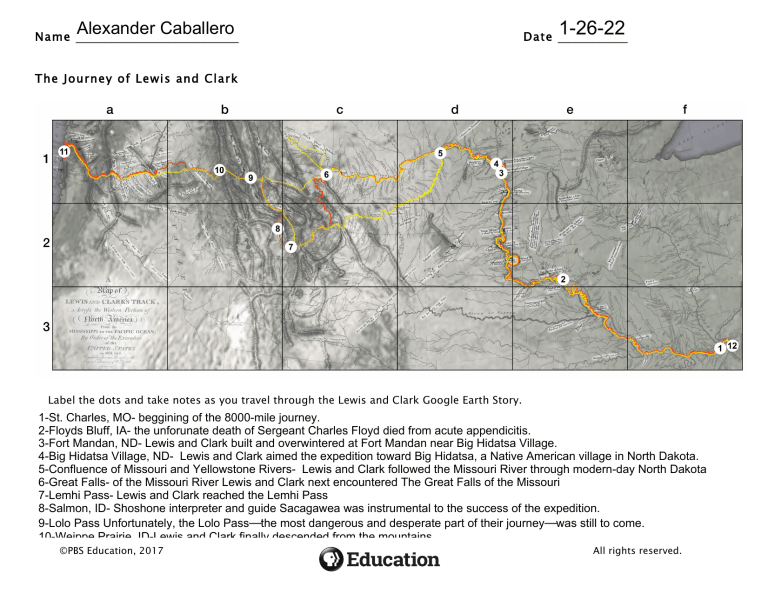
Alexander Caballero Name ____________________________ 1-26-22 Date ____________ The Journey of Lewis and Clark Label the dots and take notes as you travel through the Lewis and Clark Google Earth Story. 1-St. Charles, MO- beggining of the 8000-mile journey. 2-Floyds Bluff, IA- the unforunate death of Sergeant Charles Floyd died from acute appendicitis. 3-Fort Mandan, ND- Lewis and Clark built and overwintered at Fort Mandan near Big Hidatsa Village. 4-Big Hidatsa Village, ND- Lewis and Clark aimed the expedition toward Big Hidatsa, a Native American village in North Dakota. 5-Confluence of Missouri and Yellowstone Rivers- Lewis and Clark followed the Missouri River through modern-day North Dakota 6-Great Falls- of the Missouri River Lewis and Clark next encountered The Great Falls of the Missouri 7-Lemhi Pass- Lewis and Clark reached the Lemhi Pass 8-Salmon, ID- Shoshone interpreter and guide Sacagawea was instrumental to the success of the expedition. 9-Lolo Pass Unfortunately, the Lolo Pass—the most dangerous and desperate part of their journey—was still to come. 10-Weippe Prairie, ID-Lewis and Clark finally descended from the mountains 11-Fort OR-after ©PBSClatsop, Education, 2017 18 months of rugged exploration, Lewis and Clark finally sighted the Pacific OceanAll rights reserved. 12-St. Louis, MO-On their way back to Missouri, Lewis and Clark continued discovering and documenting new places, Name ____________________________ Date ____________ 1. Using Google Earth, pick a numeric location from the map of Lewis and Clark’s journey and explore that location today. a. How is the area different now than it was during Lewis and Clark’s time? Lolo Pass the area pass is different now because some of the area is now replaced with a visitor center. b. What did you learn about the location using Google Earth? The Lolo Pass was the most dangerous and desperate part of their journey. ©PBS Education, 2017 All rights reserved. Name ____________________________ Date ____________ 2. Using the map and the grid provided, answer the questions below: a. Which square on the grid do the remains of Big Hidatsa Village and Fort Mandan fall within (for example, 1a)? 200a __________________ The Missisipi River b. On what river did Lewis and Clark travel from Missouri to the east side of the Rocky Mountains? __________________ The Columbia c. What river took them from the west side of the Rocky Mountains to the Pacific Ocean? ____________________ 87a d. In what square on the grid lies The Great Falls of the Missouri? _________________ e. When drawing his own map, William Clark labeled common geographic features like rivers, valleys, and mountains. But he also made other notes; what (who) else did he include on his map? large-scale compass traverse maps, small page maps sketched in his journals, copies of maps prepared by traders and Indians, and composite maps of the West. ©PBS Education, 2017 All rights reserved.
