Farm Water Watch - Coachella Valley Water District
advertisement

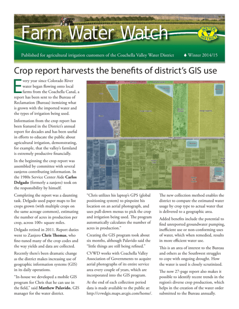
Farm Water Watch Published for agricultural irrigation customers of the Coachella Valley Water District 6 Winter 2014/15 Crop report harvests the benefits of district’s GIS use E very year since Colorado River water began flowing onto local farms from the Coachella Canal, a report has been sent to the Bureau of Reclamation (Bureau) itemizing what is grown with the imported water and the types of irrigation being used. Information from the crop report has been featured in the District’s annual report for decades and has been useful in efforts to educate the public about agricultural irrigation, demonstrating, for example, that the valley’s farmland is extremely productive financially. In the beginning the crop report was assembled by committee with several zanjeros contributing information. In the 1980s Service Center Aide Carlos Delgado (formerly a zanjero) took on the responsibility by himself. Completing the report was a daunting task. Delgado used paper maps to list crops grown (with multiple crops on the same acreage common), estimating the number of acres in production per crop, across 100+ square miles. Delgado retired in 2011. Report duties went to Zanjero Chris Thomas, who fine-tuned many of the crop codes and the way yields and data are collected. Recently there’s been dramatic change as the district makes increasing use of geographic information systems (GIS) in its daily operations. “In-house we developed a mobile GIS program for Chris that he can use in the field,” said Matthew Palavido, GIS manager for the water district. Blah, blah, blah blah, blah. “Chris utilizes his laptop’s GPS (global positioning system) to pinpoint his location on an aerial photograph, and uses pull-down menus to pick the crop and irrigation being used. The program automatically calculates the number of acres in production.” Creating the GIS program took about six months, although Palavido said the “little things are still being refined.” CVWD works with Coachella Valley Association of Governments to acquire aerial photographs of its entire service area every couple of years, which are incorporated into the GIS program. At the end of each collection period data is made available to the public at: http://cvwdgis.maps.arcgis.com/home/. The new collection method enables the district to compare the estimated water usage by crop type to actual water that is delivered to a geographic area. Added benefits include the potential to find unreported groundwater pumping, inefficient use or non-conforming uses of water, which when remedied, results in more efficient water use. This is an area of interest to the Bureau and others as the Southwest struggles to cope with ongoing drought. How the water is used is closely scrutinized. The now 27-page report also makes it possible to identify recent trends in the region’s diverse crop production, which helps in the creation of the water order submitted to the Bureau annually. Coachella Valley Water District P.O. Box 1058, Coachella, CA 92236 (760) 398-2651 Fax: (760) 391-9634 www.cvwd.org / cvwdmail@cvwd.org Board of Directors John Powell Jr., president Peter Nelson, vice-president Cástulo R. Estrada, G. Patrick O’Dowd, Ed Pack General Manager Jim Barrett Communication & Conservation Director Heather Engel Editor Jack Porrelli Photographers David Anderson, Robert Keeran Printed on 30% recycled paper Please recycle this publication Farm Water Watch Strategic Plan initiatives prioritize district’s objectives proposed five-year Canal Water Capital Improvement Program has been prepared by district staff to outline the repairs and facility replacements necessary to ensure that Colorado River water continues to be delivered to local farms and others who irrigate with the imported water. A The program stems from priorities that were identified by the Coachella Valley Water District’s Board of Directors in adoption of a five-year Strategic Plan, which also outlines what will be done to implement the priorities. The plan can be reviewed at www. cvwd.org/news/publicinfo/2014_09_2 3_2014StrategicPlan.pdf. It has six strategic goals: 1. Employee Workforce Development 2. Financial Stability 3. Water Supply Sustainability 4. Exceptional Customer Service 5. Water Quality and Environmental Leadership 6. Infrastructure Investment and Management The objectives of the sixth goal include Irrigation Infrastructure Repair and Replacement, with a comprehensive irrigation and drainage inspection targeted for no later than June 2015. Website makes water ordering easy The ability to order canal water online is available at www.cvwd.org. Customers can place water orders and monitor their consumptive water use history from anywhere using smart phones, tablets or laptops. Online service reduces and simplifies canal water ordering. This gives customers flexibility in ordering, with instant access to water use history and other detailed transaction data. An instructional video takes viewers step-by-step through web use. To place an order, go to www.cvwd.org and use the Customer Service menu at the top of the page to access the Canal Water Orders System. At an October 2014 study session the board was briefed by staff on the Canal Water Capital Improvement Program, development of which includes review of the leak/repair history for the canal/ distribution system, including monthly and annual costs; customer complaints and service issues; identification of key facilities for replacement before failures occur and a GIS facilities database. Recommended improvements include replacement of telemetry equipment and standby generators; nonpotable water connections for new canal water customers; feasibility of a north shore reservoir and expansion of canal water deliveries into the Oasis area. CVILC’s membership details are announced The Coachella Valley Irrigated Lands Coalition (CVILC) enrollment period for members begins Feb. 1, 2015. A Conditional Waiver of Waste Discharge Requirements has been approved by the Regional Water Quality Control Board. CVILC was formed to assist members with waiver compliance. Those interested in membership can contact Lorrie Cooper, (760) 3474510, or lcooper@DatesAreGreat.com to get a membership form. Assessment fees will be $3.75 per acre plus a onetime membership cost of $300.
