Global Positioning System (GPS) Technology An Explanation
advertisement

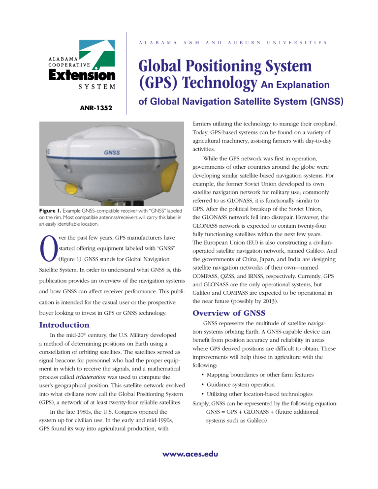
A l a b a m a A & M a n d A u b u r n U n i v e r s i t i e s Global Positioning System (GPS) Technology An Explanation ANR-1352 of Global Navigation Satellite System (GNSS) farmers utilizing the technology to manage their cropland. Today, GPS-based systems can be found on a variety of agricultural machinery, assisting farmers with day-to-day activities. cation is intended for the casual user or the prospective While the GPS network was first in operation, governments of other countries around the globe were developing similar satellite-based navigation systems. For example, the former Soviet Union developed its own satellite navigation network for military use; commonly referred to as GLONASS, it is functionally similar to GPS. After the political breakup of the Soviet Union, the GLONASS network fell into disrepair. However, the GLONASS network is expected to contain twenty-four fully functioning satellites within the next few years. The European Union (EU) is also constructing a civilianoperated satellite navigation network, named Galileo. And the governments of China, Japan, and India are designing satellite navigation networks of their own—named COMPASS, QZSS, and IRNSS, respectively. Currently, GPS and GLONASS are the only operational systems, but Galileo and COMPASS are expected to be operational in the near future (possibly by 2013). buyer looking to invest in GPS or GNSS technology. Overview of GNSS Introduction GNSS represents the multitude of satellite navigation systems orbiting Earth. A GNSS-capable device can benefit from position accuracy and reliability in areas where GPS-derived positions are difficult to obtain. These improvements will help those in agriculture with the following: Figure 1. Example GNSS-compatible receiver with “GNSS” labeled on the rim. Most compatible antennas/receivers will carry this label in an easily identifiable location. O ver the past few years, GPS manufacturers have started offering equipment labeled with “GNSS” (figure 1). GNSS stands for Global Navigation Satellite System. In order to understand what GNSS is, this publication provides an overview of the navigation systems and how GNSS can affect receiver performance. This publi- In the mid-20th century, the U.S. Military developed a method of determining positions on Earth using a constellation of orbiting satellites. The satellites served as signal beacons for personnel who had the proper equipment in which to receive the signals, and a mathematical process called trilateration was used to compute the user’s geographical position. This satellite network evolved into what civilians now call the Global Positioning System (GPS), a network of at least twenty-four reliable satellites. In the late 1980s, the U.S. Congress opened the system up for civilian use. In the early and mid-1990s, GPS found its way into agricultural production, with • Mapping boundaries or other farm features • Guidance system operation • Utilizing other location-based technologies Simply, GNSS can be represented by the following equation: GNSS = GPS + GLONASS + (future additional systems such as Galileo) www.aces.edu Advantages of GNSS Purchase Considerations The main difference between GPS and GNSS is that GNSS-compatible equipment can use navigational satellites from other networks beyond the GPS system. How is that important? The U.S. Department of Defense (USDoD) strives to maintain the integrity and reliability of at least twenty-four satellites in the GPS network; the Russian government overseeing GLONASS currently manages at least eighteen functional satellites; and the EU has placed at least two Galileo satellites into orbit. Using GPS only, users will typically observe four to eight GPS satellites at any one time, which is adequate for determining a receiver’s position in most obstruction-free environments. GNSS receivers can currently observe up to around twelve satellites, and this number is likely to increase as more satellite-based systems become operational. Manufacturers are gradually moving toward producing GNSS receivers to complement their GPS-only receiver models. When shopping for either type of receiver, the general rule of thumb is that you will be paying for accuracy and reliability. Less expensive receivers typically state accuracies within several yards of the intended target, while more expensive receivers provide accuracy to within an inch or less. Benefits of GNSS include the following: • More satellites to track, which can increase receiver accuracy and reliability • A shorter warm-up time (known as “time to first fix”) • Reduced delay in recomputing a position if satellite signals are temporarily blocked by obstructions (reaquisition time) • The ability to compute a position in situations that were previously too difficult for a standalone GPS receiver operation—especially near tree lines, buildings, large obstacles, etc. To avoid confusion, remember that GNSS receivers are, by definition, compatible with GPS; however, GPS receivers are not necessarily compatible with GNSS. Here are a few points to consider when purchasing a GPS or GNSS receiver: • Determine the level of position accuracy that is needed for your application(s). • A legitimate concern for most users is that, from an agricultural standpoint, GNSS technology needs to be fully developed and thoroughly tested before an investment is made in adapting GNSS to current GPS-only systems. However, another concern as technology develops is that some manufacturers will phase out their GPS-only line. Currently, a GNSS receiver may cost more but will provide benefits in the long run. • Determine if the hardware and software is upgradeable so you can take advantage of new features. For example, the internal components and circuitry required to interpret GLONASS signals is similar to that required for GPS signals, but the components required to receive Galileo signals are different. Future satellite systems may require even more diverse equipment changes—will your equipment provider supply you with a newly enhanced receiver when it becomes available? • Inquire about warranty or service contract terms. Determine whether the conditions of the contract will cover both hardware and software malfunctions. John Fulton, Extension Specialist and Assistant Professor, Tyrel Harbuck, Graduate Student, and Daniel Mullenix, Research Engineer, Biosystems Engineering; Brenda Ortiz, Extension Specialist and Assistant Professor, Agronomy and Soils, all with Auburn University; Amy Winstead, Regional Extension Agent and Shannon Norwood, County Extension Agent. For more information, call your county Extension office. Look in your telephone directory under your county’s name to find the number. ANR-1352 Issued in furtherance of Cooperative Extension work in agriculture and home economics, Acts of May 8 and June 30, 1914, and other related acts, in cooperation with the U.S. Department of Agriculture. The Alabama Cooperative Extension System (Alabama A&M University and Auburn University) offers educational programs, materials, and equal opportunity employment to all people without regard to race, color, national origin, religion, sex, age, veteran status, or disability. New July 2009, ANR-1352 © 2009 by the Alabama Cooperative Extension System.


