CR/04/216N
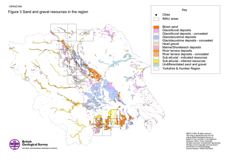
Figure 3 Sand and gravel resources in the region
%
Cities
IMAU areas
Key
Blown sand
Glaciofluvial deposits
Glaciofluvial deposits - concealed
Glaciolacustrine deposits
Glaciolacustrine deposits - concealed
Head gravel
Marine/Shorebeach deposits
River terrace deposits
River terrace deposits - concealed
Sub-alluvial - indicated resources
Sub-alluvial - inferred resources
Undifferentiated sand and gravel
Yorkshire & Humber Region
NERC © 2004 All rights reserved.
This map is reproduced from the OS
map by British Geological Survey on
behalf of The Controller of Her Majesty's
Stationery Office, Crown Copyright.
All rights reserved. Unauthorised reproduction
infringes Crown Copyright and may lead to
prosecution or civil proceedings.
Licence Number: 1000017897/2004
CR/04/216N
Figure 4 Sand and gravel resources potentially suitable for concreting purposes
Key
%
Cities
Glaciofluvial deposits
Glaciofluvial deposits - concealed
River terrace deposits
River terrace deposits - concealed
Sub-alluvial - indicated resources
Sub-alluvial - inferred resources
Yorkshire & Humber Region
NERC © 2004 All rights reserved.
This map is reproduced from the OS
map by British Geological Survey on
behalf of The Controller of Her Majesty's
Stationery Office, Crown Copyright.
All rights reserved. Unauthorised reproduction
infringes Crown Copyright and may lead to
prosecution or civil proceedings.
Licence Number: 1000017897/2004
CR/04/216N
Key
Figure 5 Environmental sensitivity using all available assets
Number of assets
9
8
7
6
5
4
3
2
1
%
Cities
Yorkshire & Humber Region
%
Ripon
York
%
Environmental & cultural assets used:
Agricultural land: Best & Most Versatile (BMV)
Ancient Woodland
Area of Outstanding Natural Beauty
Community Forest
Doorstep Green
Groundwater Source Protection Zones
Heritage Coast
Local Nature Reserve
Millennium Green
National Nature Reserve
National Park
Ramsar Wetlands
RSPB Important Bird Areas (IBAS)
RSPB Reserve
Scheduled Ancient Monument
Site of Special Scientific Interest
Special Protection Area
Special Area of Conservation
Woodland Trust Sites
Bradford%
Leeds
%
Kingston upon Hull
%
%
Wakefield
Sheffield
%
NERC © 2004 All rights reserved.
This map is reproduced from the OS
map by British Geological Survey on
behalf of The Controller of Her Majesty's
Stationery Office, Crown Copyright.
All rights reserved. Unauthorised reproduction
infringes Crown Copyright and may lead to
prosecution or civil proceedings.
Licence Number: 1000017897/2004
CR/04/216N
Figure 6 An example of environmental sensitivity using certain assets only
Key
Number of assets
5
4
3
2
1
Yorkshire & Humber Region
%
Ripon
York
%
Bradford
%
Leeds
%
Kingston upon Hull
%
%
Environmental and cultural assets used
Area of Outstanding Natural Beauty
Heritage Coast
National Nature Reserve
National Park
Ramsar Wetlands
Site of Special Scientific Interest
Special Protection Area
Special Area of Conservation
Wakefield
Sheffield
%
NERC © 2004 All rights reserved.
This map is reproduced from the OS
map by British Geological Survey on
behalf of The Controller of Her Majesty's
Stationery Office, Crown Copyright.
All rights reserved. Unauthorised reproduction
infringes Crown Copyright and may lead to
prosecution or civil proceedings.
Licence Number: 1000017897/2004
CR/04/216N
Figure 7 Urban areas in the region
Key
%
Cities
Urban areas
Yorkshire & Humber Region
%
Ripon
York
%
Bradford%
Leeds
%
%
Wakefield
Kingston upon Hull
%
Sheffield
%
NERC © 2004 All rights reserved.
This map is reproduced from the OS
map by British Geological Survey on
behalf of The Controller of Her Majesty's
Stationery Office, Crown Copyright.
All rights reserved. Unauthorised reproduction
infringes Crown Copyright and may lead to
prosecution or civil proceedings.
Licence Number: 1000017897/2004
CR/04/216N
Figure 8 Transport in the region
Key
%
Cities
Rail
Primary roads
Motorways
Yorkshire & Humber Region
%
Ripon
York
%
Bradford%
Leeds
%
Kingston upon Hull
%
%
Wakefield
Sheffield
%
NERC © 2004 All rights reserved.
This map is reproduced from the OS
map by British Geological Survey on
behalf of The Controller of Her Majesty's
Stationery Office, Crown Copyright.
All rights reserved. Unauthorised reproduction
infringes Crown Copyright and may lead to
prosecution or civil proceedings.
Licence Number: 1000017897/2004
CR/04/216N
Figure 9 Location of airports/airfields and 13 km buffer zones
Key
Durham Tees Valley
o
Airports and airfields
o
o
q
o RAF Leeming
Topcliffe o oBagby
Civil
Military
Officially safeguarded civil
Airport buffer 13 km
Yorkshire & Humber Region
o Dishforth
o RAF Linton-on-Ouse
Elvington
o Pocklington
Leeds Bradford International
o RAF Leaconfield
q
o RAF Church Fenton
o
Sherburn-in-Elmet
o
Brough
o
Sandtoft
o
q Humberside International
o
Robin Hood Doncaster Sheffield
o Sheffield City
o
Sturgate
o
Netherthorpe
NERC © 2004 All rights reserved.
This map is reproduced from the OS
map by British Geological Survey on
behalf of The Controller of Her Majesty's
Stationery Office, Crown Copyright.
All rights reserved. Unauthorised reproduction
infringes Crown Copyright and may lead to
prosecution or civil proceedings.
Licence Number: 1000017897/2004
CR/04/216N
Figure 10 Published BGS data in the region
Boxes in green outline the 1:50,000
published geological maps.
Boxes in black outline the 1:25,000
published maps (IMAU Industrial Minerals
Assessment Unit sand and gravel resources maps).
NERC © 2004 All rights reserved.
This map is reproduced from the OS
map by British Geological Survey on
behalf of The Controller of Her Majesty's
Stationery Office, Crown Copyright.
All rights reserved. Unauthorised reproduction
infringes Crown Copyright and may lead to
prosecution or civil proceedings.
Licence Number: 1000017897/2004
