0 mi
20
40
9:00 AM
0.0 mi
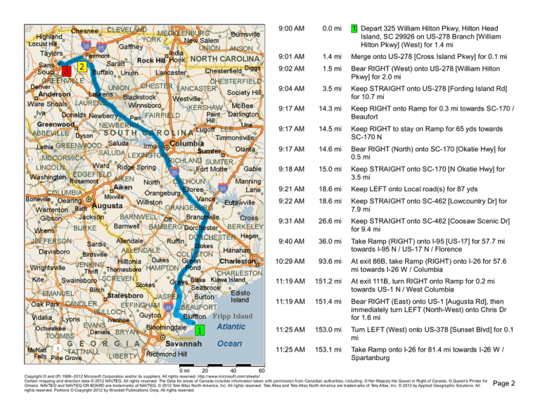
1 Depart 325 William Hilton Pkwy, Hilton Head
Island, SC 29926 on US-278 Branch [William
Hilton Pkwy] (West) for 1.4 mi
9:01 AM
1.4 mi
Merge onto US-278 [Cross Island Pkwy] for 0.1 mi
9:02 AM
1.5 mi
Bear RIGHT (West) onto US-278 [William Hilton
Pkwy] for 2.0 mi
9:04 AM
3.5 mi
Keep STRAIGHT onto US-278 [Fording Island Rd]
for 10.7 mi
9:17 AM
14.3 mi
Keep RIGHT onto Ramp for 0.3 mi towards SC-170 /
Beaufort
9:17 AM
14.5 mi
Keep RIGHT to stay on Ramp for 65 yds towards
SC-170 N
9:17 AM
14.6 mi
Bear RIGHT (North) onto SC-170 [Okatie Hwy] for
0.5 mi
9:18 AM
15.0 mi
Keep STRAIGHT onto SC-170 [N Okatie Hwy] for
3.5 mi
9:21 AM
18.6 mi
Keep LEFT onto Local road(s) for 87 yds
9:22 AM
18.6 mi
Keep STRAIGHT onto SC-462 [Lowcountry Dr] for
7.9 mi
9:31 AM
26.6 mi
Keep STRAIGHT onto SC-462 [Coosaw Scenic Dr]
for 9.4 mi
9:40 AM
36.0 mi
Take Ramp (RIGHT) onto I-95 [US-17] for 57.7 mi
towards I-95 N / US-17 N / Florence
10:29 AM
93.6 mi
At exit 86B, take Ramp (RIGHT) onto I-26 for 57.6
mi towards I-26 W / Columbia
11:19 AM
151.2 mi
At exit 111B, turn RIGHT onto Ramp for 0.2 mi
towards US-1 N / West Columbia
11:19 AM
151.4 mi
Bear RIGHT (East) onto US-1 [Augusta Rd], then
immediately turn LEFT (North-West) onto Chris Dr
for 1.6 mi
11:25 AM
153.0 mi
Turn LEFT (West) onto US-378 [Sunset Blvd] for 0.1
mi
11:25 AM
153.1 mi
Take Ramp onto I-26 for 81.4 mi towards I-26 W /
Spartanburg
60
Copyright © and (P) 1988–2012 Microsoft Corporation and/or its suppliers. All rights reserved. http://www.microsoft.com/streets/
Certain mapping and direction data © 2012 NAVTEQ. All rights reserved. The Data for areas of Canada includes information taken with permission from Canadian authorities, including: © Her Majesty the Queen in Right of Canada, © Queen's Printer for
Ontario. NAVTEQ and NAVTEQ ON BOARD are trademarks of NAVTEQ. © 2012 Tele Atlas North America, Inc. All rights reserved. Tele Atlas and Tele Atlas North America are tradem arks of Tele Atlas, Inc. © 2012 by Applied Geographic Solutions. All
rights reserved. Portions © Copyright 2012 by W oodall Publications Corp. All rights reserved.
Page 2
0 mi 2
4
6
8
12:35 PM
234.5 mi
At exit 28, turn RIGHT onto Ramp for 0.2 mi towards
US-221 / Spartanburg-South / Moore
12:36 PM
234.8 mi
Keep LEFT to stay on Ramp for 32 yds towards
US-221 S / Woodrff
12:36 PM
234.8 mi
Bear LEFT (North-West) onto Local road(s) for 10
yds
12:36 PM
234.8 mi
Turn LEFT (South-West) onto US-221 for 0.9 mi
12:36 PM
235.7 mi
Turn RIGHT (North) onto SC-290 for 0.8 mi
12:38 PM
236.5 mi
Keep STRAIGHT onto SC-290 [Moore Duncan Hwy]
for 5.3 mi
12:44 PM
241.8 mi
Keep STRAIGHT onto SC-290 [E Main St] for 3.1 mi
12:48 PM
244.9 mi
Take Ramp (LEFT) onto I-85 for 3.1 mi
12:52 PM
248.0 mi
At exit 60, turn RIGHT onto Ramp for 0.3 mi towards
SC-101 / Greer / Woodruff
12:52 PM
248.3 mi
Keep STRAIGHT to stay on Ramp for 87 yds
towards SC-101 N / Greer
12:52 PM
248.4 mi
Bear RIGHT (North-West) onto SC-101 [Highway
101 S] for 0.3 mi
12:52 PM
248.7 mi
Turn LEFT (South-West) onto Old Woodruff Rd for
21 yds
12:53 PM
248.7 mi
2 At BMW Zentrum Museum [1400 SC-101 S,
Greer SC 29651, United States, Tel:
+(1)-864-9895297], turn LEFT (South-East) onto
SC-101 [Highway 101 S] for 0.3 mi
12:53 PM
249.0 mi
Take Ramp (RIGHT) onto I-85 for 8.5 mi towards
I-85 S / GSP Int'l Airport / Greenville
1:02 PM
257.5 mi
At exit 51, turn RIGHT onto Ramp for 0.3 mi towards
I-385 / Columbia / Greenville
1:02 PM
257.8 mi
Take Ramp (RIGHT) onto I-385 for 4.1 mi towards
I-385 N / Greenville / Downtown
1:06 PM
261.9 mi
At exit 40B, take Ramp onto SC-291 [N
Pleasantburg Dr] for 0.9 mi towards SC-291 S /
Pleasantburg Dr
10
Copyright © and (P) 1988–2012 Microsoft Corporation and/or its suppliers. All rights reserved. http://www.microsoft.com/streets/
Certain mapping and direction data © 2012 NAVTEQ. All rights reserved. The Data for areas of Canada includes information taken with permission from Canadian authorities, including: © Her Majesty the Queen in Right of Canada, © Queen's Printer for
Ontario. NAVTEQ and NAVTEQ ON BOARD are trademarks of NAVTEQ. © 2012 Tele Atlas North America, Inc. All rights reserved. Tele Atlas and Tele Atlas North America are tradem arks of Tele Atlas, Inc. © 2012 by Applied Geographic Solutions. All
rights reserved. Portions © Copyright 2012 by W oodall Publications Corp. All rights reserved.
Page 3
1:08 PM
0 yds
200
262.8 mi
3 Arrive 246 N Pleasantburg Dr, Greenville, SC
29607
400
Copyright © and (P) 1988–2012 Microsoft Corporation and/or its suppliers. All rights reserved. http://www.microsoft.com/streets/
Certain mapping and direction data © 2012 NAVTEQ. All rights reserved. The Data for areas of Canada includes information taken with permission from Canadian authorities, including: © Her Majesty the Queen in Right of Canada, © Queen's Printer for
Ontario. NAVTEQ and NAVTEQ ON BOARD are trademarks of NAVTEQ. © 2012 Tele Atlas North America, Inc. All rights reserved. Tele Atlas and Tele Atlas North America are tradem arks of Tele Atlas, Inc. © 2012 by Applied Geographic Solutions. All
rights reserved. Portions © Copyright 2012 by W oodall Publications Corp. All rights reserved.
Page 4


