Alert / warning issuing authorities and their jurisdictions Torrential
advertisement
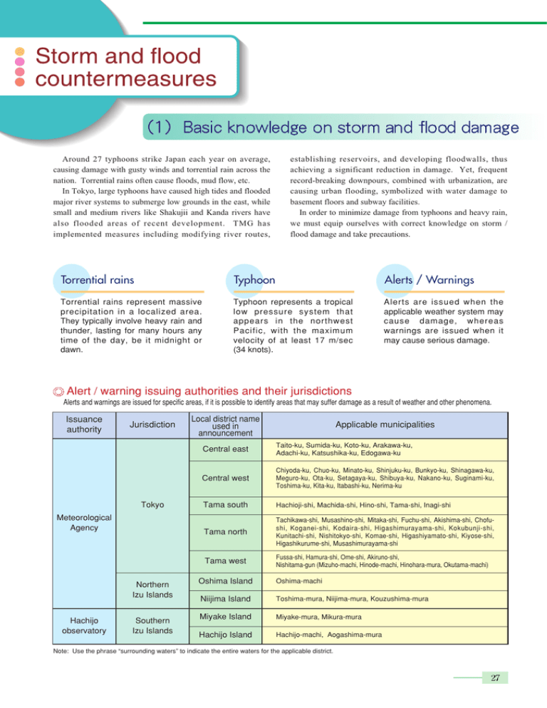
Around 27 typhoons strike Japan each year on average, causing damage with gusty winds and torrential rain across the nation. Torrential rains often cause floods, mud flow, etc. In Tokyo, large typhoons have caused high tides and flooded major river systems to submerge low grounds in the east, while small and medium rivers like Shakujii and Kanda rivers have also flooded areas of recent development. TMG has implemented measures including modifying river routes, establishing reservoirs, and developing floodwalls, thus achieving a significant reduction in damage. Yet, frequent record-breaking downpours, combined with urbanization, are causing urban flooding, symbolized with water damage to basement floors and subway facilities. In order to minimize damage from typhoons and heavy rain, we must equip ourselves with correct knowledge on storm / flood damage and take precautions. Torrential rains Typhoon Alerts / Warnings Torrential rains represent massive precipitation in a localized area. They typically involve heavy rain and thunder, lasting for many hours any time of the day, be it midnight or dawn. Typhoon represents a tropical low pressure system that appears in the northwest Pacific, with the maximum velocity of at least 17 m/sec (34 knots). Alerts are issued when the applicable weather system may cause damage, whereas warnings are issued when it may cause serious damage. Alert / warning issuing authorities and their jurisdictions Alerts and warnings are issued for specific areas, if it is possible to identify areas that may suffer damage as a result of weather and other phenomena. Issuance authority Jurisdiction Tokyo Meteorological Agency Northern Izu Islands Hachijo observatory Southern Izu Islands Local district name used in announcement Applicable municipalities Central east Taito-ku, Sumida-ku, Koto-ku, Arakawa-ku, Adachi-ku, Katsushika-ku, Edogawa-ku Central west Chiyoda-ku, Chuo-ku, Minato-ku, Shinjuku-ku, Bunkyo-ku, Shinagawa-ku, Meguro-ku, Ota-ku, Setagaya-ku, Shibuya-ku, Nakano-ku, Suginami-ku, Toshima-ku, Kita-ku, Itabashi-ku, Nerima-ku Tama south Hachioji-shi, Machida-shi, Hino-shi, Tama-shi, Inagi-shi Tama north Tachikawa-shi, Musashino-shi, Mitaka-shi, Fuchu-shi, Akishima-shi, Chofushi, Koganei-shi, Kodaira-shi, Higashimurayama-shi, Kokubunji-shi, Kunitachi-shi, Nishitokyo-shi, Komae-shi, Higashiyamato-shi, Kiyose-shi, Higashikurume-shi, Musashimurayama-shi Tama west Fussa-shi, Hamura-shi, Ome-shi, Akiruno-shi, Nishitama-gun (Mizuho-machi, Hinode-machi, Hinohara-mura, Okutama-machi) Oshima Island Oshima-machi Niijima Island Toshima-mura, Niijima-mura, Kouzushima-mura Miyake Island Miyake-mura, Mikura-mura Hachijo Island Hachijo-machi, Aogashima-mura Note: Use the phrase “surrounding waters” to indicate the entire waters for the applicable district. Main alerts and warnings for storm / flood damage, issued by the Japan Meteorological Agency and Hachijo observatory, and their issuance criteria Meteorological warning Meteorological alert Type Region Issuance criteria When the average velocity is projected to be over 13m/sec (or 16m/sec if observed by the Hachioji observatory) Tokyo Strong wind Northern Izu Islands When the average velocity is projected to be over 15m/sec (or 12m/sec if observed by the Oshima observatory) alerts Southern Izu Islands When the average velocity is projected to be over 15m/sec Heavy Tokyo rain alerts Central and Tama north / south Tama west Precipitation in 3 hours Precipitation in 24 hours Over 30mm Over 70mm Over 130mm Over 50mm Over 90mm Over 180mm Over 30mm (total precipitation of 70mm) Over Kouzushima Island Niijima Island of 20mm Over 30mm Over Miyake Island of 20mm Over 50mm Over Kouzushima Island Niijima Island of 40mm Over 60mm Over Miyake Island of 35mm Over 150mm Over Kouzushima Island Niijima Island of 80mm Over 150mm Over Miyake Island of 100mm When the average velocity is projected to be over 25m/sec Strong wind warning Heavy Tokyo rain warning Precipitation in 1 hour When the average velocity is projected to be over 25m/sec (or 20m/sec if observed by the Oshima observatory) When the average velocity is projected to be over 30m/sec Central and Tama north / south Tama west Precipitation in 1 hour Precipitation in 3 hours Precipitation in 24 hours Over 50mm (total precipitation of 80mm) Over 90mm Over 200mm Over 70mm Over 120mm Over 250mm Over 50mm (total precipitation of 150mm) Over Kouzushima Island Niijima Island of 40mm Over 50mm (total precipitation of 150mm) Over Miyake Island of 30mm Over 100mm Over Kouzushima Island Niijima Island of 80mm Over 100mm Over Miyake Island of 60mm Over 300mm Over Kouzushima Island Niijima Island of 140mm Over 300mm Over Miyake Island of 200mm Note: The figures shown as issuance criteria have been defined based on past correlation between meteorological conditions and disaster frequency in Tokyo, and should be used as a guide in predicting the likelihood of weather-induced damage under certain meteorological conditions. High tide Lands near a shoaling beach, at the end of a bay or at the mouth of a river When the tide is high, the sea level is likely to surge at a shoaling beach that has the seabed dropping suddenly off the coast, and land at the end of a bay. Coastal land close to sea level Be aware of low grounds positioned below the average sea level at high tide. Such areas are prone to serious flood damage if sea walls give way. Flooding Landslide Alluvial plain Reconstructed land Flooding is likely at “delta plains” created near the mouth of a river with sand and soil carried in the river water, or at “flood plains” created through accumulation of sand and soil as a result of repeated flooding. Tracts of land, developed on a hillside, have unstable soil properties and shapes. Torrential rain could weaken and collapse the foundation. Alluvial fan Riverbank Areas along rivers and lands that used to form riverbanks, are vulnerable to flooding at the time of torrential rain. Landslides, caused by a localized rainstorm at a mountainous region, may strike an alluvial fan at the foot of the mountain. Mountainous region Sharp slopes at the gradient of over 30 degrees and height of over 5 meters, may cause landslide with heavy rain. Mountainous areas with low vegetation density are also prone to landslide. Typhoons and rainstorms should not be taken lightly although their arrival can be predicted. It is important to take precautions to minimize storm / flood damage. Outside preparation Securely lock all windows and rain screens, and reinforce with timber from outside if necessary. Reinforce garden trees and fences. Clear gutters and storm-water pipes for better drainage. Check and reinforce the stay cables and bracing for TV antenna. Affix or store indoors objects that may be blown away with winds. Inside preparation Checks on emergency supplies Flashlight, portable radio (batteries), first aid kit, clothes / valuables, emergency foods, portable cook-top Safety measures from inside Close rain screens, apply packing tape on windowpanes to prevent the glass from shattering, and close curtains / blinds in case of any airborne objects flying in through the windows. Water Set aside drinking water in case the water supply becomes suspended, and fill the bathtub with water for miscellaneous household use. Evacuation locations Each municipality has a list of designated evacuation areas. Check your designated area in case evacuation is required. Attention to typhoon information When a typhoon is approaching, meteorological authorities issue upto-date typhoon information, which is broadcast on TV and radio. When you learn of an approaching typhoon, conduct a safety check around the house. Attention to alerts / warnings Alerts / warnings are issued when the approaching typhoon is expected to deliver damage. Use TV and radio to be aware of the latest alerts / warnings. Staying away from hazardous areas It becomes difficult to see the edges of rain-swollen streams and gutters, causing many people to miss the steps and fall in. They also trigger mudslides and landslides. Inspection of emergency supplies Check your emergency supplies. Evacuation preparation Check the route to your evacuation area, method of evacuation instructions, and cooperative arrangement with neighbors, so as to be well prepared when an evacuation order is actually issued. Evacuation Be well prepared for swift evacuation when you feel imminent danger or are instructed to evacuate by disaster management authorities. Make sure to put out any fires and flames before evacuation. Keep your luggage to a minimum and carry it on your back when evacuating, so that both of your hands are available for emergency protection. Act prudently according to the instructions of the leader. At the evacuation site Follow the instructions of the leader, rather than act on your personal judgment. Continue to pay attention to typhoon information, alerts and warnings.
