Sea-water intrusion
Where aquifers form a coastline, a natural
gradient exists towards the coast and
groundwater discharges into the sea. Because sea
water is slightly heavier than fresh water, it
intrudes into aquifers in coastal areas forming a
saline wedge below the fresh water. The
boundary, or interface, between the two is in a
state of dynamic equilibrium, moving with the
seasonal variations of the water table and daily
tidal fluctuations. These movements mean the
interface is actually a transition zone of mixed
salinity.
The theoretical interface actually occurs at a depth
below sea level that is 40 times the height of fresh
water above sea level; this relationship is called
the Ghyben-Herzberg relation, after the two
European scientists who independently
recognised it at the turn of the century. In practise
geological variability makes the relationship more
complex.
When groundwater is pumped from a coastal
aquifer the fresh-water level is lowered and the
sea intrudes further into the aquifer.
UK Groundwater Forum
With excessive pumping the natural hydraulic
gradient towards the sea may be reversed and the
intrusion can then extend to the pumping
borehole which becomes saline.
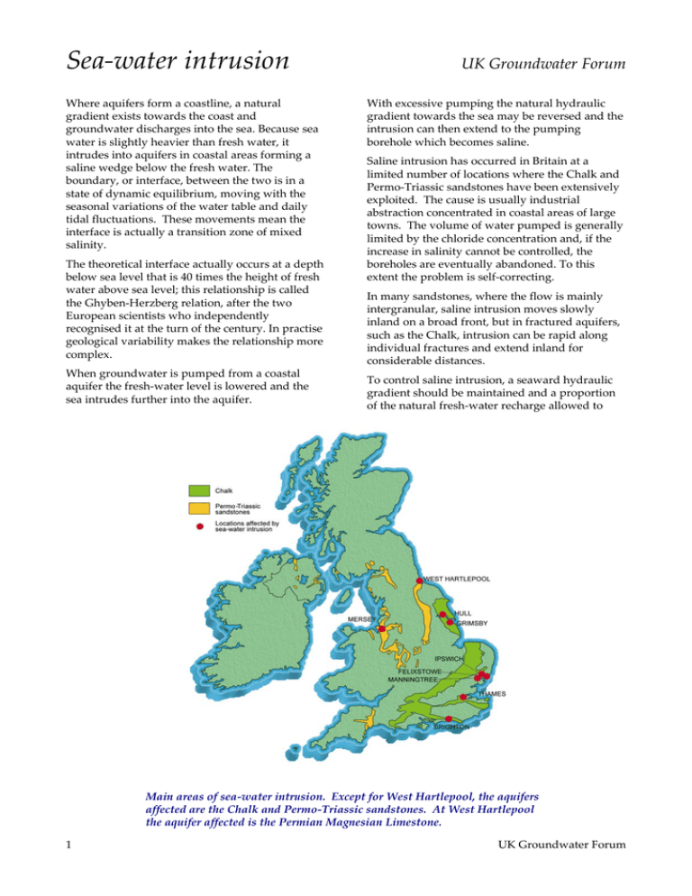
Saline intrusion has occurred in Britain at a
limited number of locations where the Chalk and
Permo-Triassic sandstones have been extensively
exploited. The cause is usually industrial
abstraction concentrated in coastal areas of large
towns. The volume of water pumped is generally
limited by the chloride concentration and, if the
increase in salinity cannot be controlled, the
boreholes are eventually abandoned. To this
extent the problem is self-correcting.
In many sandstones, where the flow is mainly
intergranular, saline intrusion moves slowly
inland on a broad front, but in fractured aquifers,
such as the Chalk, intrusion can be rapid along
individual fractures and extend inland for
considerable distances.
To control saline intrusion, a seaward hydraulic
gradient should be maintained and a proportion
of the natural fresh-water recharge allowed to
Main areas of sea-water intrusion. Except for West Hartlepool, the aquifers
affected are the Chalk and Permo-Triassic sandstones. At West Hartlepool
the aquifer affected is the Permian Magnesian Limestone.
1
UK Groundwater Forum
flow into the sea. The management of a coastal
aquifer is actually concerned with deciding upon
an acceptable ultimate landward extent of the
saline water and calculating the amount of freshwater discharge necessary to keep it in that
position.
The risk of saline intrusion clearly limits the
extent to which a coastal aquifer can be developed
for water supply but the proportion of the
infiltration that can be used can be increased by
skilful management.
Along the south bank of the Humber, where the
aquifer in question is again the Chalk, a similar
problem has been overcome by using
groundwater from the aquifer and surface water
from the rivers Trent and Ancholme, in
conjunction. Each source is used at different times
of the year according to its availability.
Controlling the sea
Various methods have been advocated for the
control of saline intrusion but the pragmatic and
cheapest solution is to reduce and/or rearrange
the pattern of boreholes abstracting groundwater.
This approach has been very successfully applied
near Brighton where the Chalk is affected by
intrusion, in this case because of abstraction for
public supply. The policy adopted is that in the
winter, when fresh-water flow to the sea is large,
boreholes near the sea are used to provide most of
the supply and inland boreholes are rested. This
situation is reversed in the summer when the flow
of fresh water to the sea is much reduced and the
potential for intrusion thereby increased.
The relationship between fresh and saline
groundwater in a coastal aquifer. The position of
the interface between the fresh and saline
groundwater is related to the difference in density
of the two waters. The depth of the interface
below sea level is about 40 times the height of
fresh-water above sea level. That is h2 = 40h1.
Seasonal abstraction patterns in the Chalk aquifers near Brighton. The Chalk is a fractured limestone and
saline intrusion penetrates inland along individual fractures. To reduce this tendency, most of the
abstraction in winter is near the coast, to intercept the strong groundwater flow to the sea at this time. This
conserves groundwater storage and allows water levels to recover in the aquifer. In summer most of the
abstraction is from inland boreholes when groundwater flow to the sea is weaker. Abstraction from coastal
boreholes is then reduced or stopped altogether.
British Geological Survey. © NERC. All rights reserved [IPR/47–4]
2
UK Groundwater Forum


