Leicestershire County Council
Risk Assessment of
Walking Routes to School
©
Crown copyright. All rights reserved. Leicestershire County Council. 100019271. Published 2010.
2009/10 School Year
Route No. 9
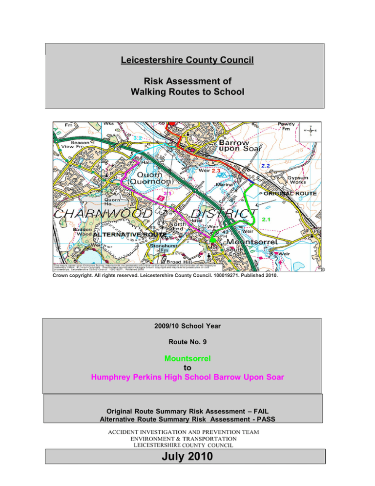
Mountsorrel
to
Humphrey Perkins High School Barrow Upon Soar
Original Route Summary Risk Assessment – FAIL
Alternative Route Summary Risk Assessment - PASS
ACCIDENT INVESTIGATION AND PREVENTION TEAM
ENVIRONMENT & TRANSPORTATION
LEICESTERSHIRE COUNTY COUNCIL
July 2010
2
Contents
1.0
RECORDED PERSONAL INJURY ACCIDENT DATA
2.0
THE ROUTE
2.1
Section 1 – Sileby Road junction with Market Street Mountsorrel & Slash Lane
to Sileby road Barrow.
2.2
Section 2 – Sileby Road Barrow upon Soar from Slash Lane to Huston Close
Barrow.
2.3
Section 3 – Sileby Road, along South Street, High Street & Cotes Road Barrow
upon Soar, to Humphrey Perkins School.
3.0 ALTERNATIVE ROUTE
3.1
Section 1 – Loughborough Road Mountsorrel, from the junction of Sileby Road.
Leicester Road, School Lane, Soar Road & Meynell Road to the
junction of road to Quorn Hall.
3.2
Section 2 – Footpath from Quorn Hall to Bridge Street Barrow, along Bridge
Street, High Street & Cotes Road Barrow upon Soar, to
Humphrey Perkins School.
3
1.0
RECORDED PERSONAL INJURY ACCIDENT DATA
In the five year period to March 2010, there were 24 recorded accidents involving
personal injury on the route. Only 2 of these accidents involved a pedestrian and are
detailed below:
June 2007
Barrow upon Soar - Cotes Road near The Rookery. A van travelling southeast clipped
the arm of a child pedestrian who was walking on the footway with its nearside wing
mirror causing minor injuries.
December 2007
Barrow upon Soar - Cotes Road outside Humphrey Perkins School. A car travelling
south collided with a child pedestrian crossing from the nearside causing minor injuries.
1. 1 ALTERNATIVE ROUTE - RECORDED PERSONAL INJURY ACCIDENT DATA
In the five year period to March 2010, there were 11 recorded accidents involving
personal injury on this route. There were no additional pedestrian accidents on the
alternative route other then those detailed above.
4
2.0 THE ROUTE
2.1 Section 1 – Sileby Road junction with Market Street Mountsorrel & Slash Lane
to Sileby road Barrow.
2.2 Section 2 – Sileby Road Barrow upon Soar from Slash Lane to Huston Close
Barrow.
2.3 Section 3 – Sileby Road, along South Street, High Street & Cotes Road Barrow
upon Soar, to Humphrey Perkins School.
3.0 ALTERNATIVE ROUTE
3.1
Section 1 – Loughborough Road Mountsorrel, from the junction of Sileby Road.
Leicester Road, School Lane, Soar Road & Meynell Road to the
junction of road to Quorn Hall.
3.2
Section 2 – Footpath from Quorn Hall to Bridge Street Barrow, along Bridge
Street, High Street & Cotes Road Barrow upon Soar, to
Humphrey Perkins School.
Date & Time of Assessment:
7 June 2010 15.00 – 16.00
Weather :
Fine & Dry
This risk assessment is undertaken in accordance with guidelines developed by
Leicestershire County Council (LCC) under the terms and definitions of the Education
Act.
Any opinions expressed by the Safety Assessor are based on the LCC guidelines and
the experienced professional judgement of the Safety Assessor of any identified risks on
the route that could contribute to injuries to vulnerable road users.
Only items of concern have been noted within the report.
5
2.1 Sileby Road Mountsorrel & Slash Lane Sileby
Section Characteristics
This section covers Sileby Road from the junction with Market Place to Slash Lane, and
Slash Lane to the junction with Sileby Road Barrow upon Soar. Apart from a short stretch
of 30mph leaving Mountsorrel village, Sileby Road is subject to the national speed limit
but has footway. Slash Lane is also national speed limit and is a narrow winding county
road with no footway or street lighting.
Section length: 2.0 Km
Crossing - Assessment
There is no need to cross on this section.
(PASS)
Walking Alongside Road – Assessment
There is no footway along Slash Lane, and the canal bridge section were also very
poor visibility. The verge is rough and very narrow in places, making it unsuitable for
walking on. Sections of Slash Lane are subject to regular severe flooding.
(FAIL)
Other
None
Alternative Routes
See section 3.1 and 3.2
Overall Section Summary Risk Assessment - FAIL
No photographs taken.
6
2.2 - Sileby Road Barrow upon Soar.
Section Characteristics
This section covers the length of the 40mph speed limit on Sileby Road from Slash Lane
to the entrance to Barrow upon Soar where the 30mph limit begins. There are industrial
estates and houses on both sides of the road which has footway along the whole length.
Section length: 0.4 km
Crossing - Assessment
There is a point opposite Huston Close where the hedge has overgrown over the footway
(See photograph below). It is not possible to cross to the other side of the carriageway as
there is no footway on that side. However, it is felt that this could be rectified and made
passable with a little maintenance.
(FAIL)
Walking Alongside Road - Assessment
There is continuous footway along the whole of this length. Two-way traffic is estimated
at more then 240 vehicles per hour and less then 24 HGVs an hour.
(PASS)
Other
None
Alternative Routes
See sections 3.1 and 3.2
Overall Section Summary Risk Assessment - FAIL
Illustration Photograph
Sileby Road Footway opposite Huston Close
7
2.3 -Sileby Road, South Street, High Street and Cotes Road Barrow upon Soar.
Section Characteristics
This section starts on Sileby Road at the village entry to Barrow and continues along
South Street, High Street and Cotes Road ending at the entrance to the school. The
whole length has a 30mph speed limit and there are houses and footway on both sides of
the carriageway.
Section length: 2.1 Km
Crossing – Assessment
It is necessary to cross Sileby Road onto the North footway. There are marked crossing
points with central refuges on Sileby Road. There are two Zebra crossings on High
Street. Cotes Road is a school Safety Zone. There is a more then 4 second of sighting
time for drivers to see pedestrians and waiting time to cross is less than 40 seconds on
all these roads
(PASS)
Walking Alongside Road - Assessment
There is good footway along the whole of this route. Two-way traffic is estimated at more
than 240 vehicles per hour and less than 24 HGVs an hour.
(PASS)
Other
None
Alternative Routes
See sections 3.1 and 3.2
Overall Section Summary Risk Assessment - PASS
Illustration Photographs
High Street Barrow Upon Soar
Cotes Road Barrow Upon Soar
8
ALTERNATIVE ROUTE
3.1 - Loughborough Road Mountsorrel & Leicester Road, School Lane, Soar Road
& Meynell Road Quorn
Section Characteristics
This section covers the length of Loughborough Road Mountsorrel from its junction with
Market Place, and continues along Leicester Road Quorn to its junction with School
Lane. It then continues along School Lane, Soar Road and Meynell Road to the entrance
to Quorn Hall. The speed limit along the route is predominantly 30mph except for a short
stretch between the Granite Way roundabout and Wood Lane which is 40mph. There is
footway along the whole route and street lighting.
Section length: 3.0km
Crossing - Assessment
It is necessary to cross at the roundabout with Granite Way. There are marked
pedestrian crossing points all round the roundabout. There is a more then 4 seconds of
sighting time for drivers to see pedestrians and waiting time to cross is less than 40
seconds.
(PASS)
Walking Alongside Road - Assessment
There is footway present along the whole length of the route. Two-way traffic is
estimated at more than 240 vehicles per hour and less than 24 HGVs an hour.
(PASS)
Other
None
Alternative Routes
None
Overall Section Summary Risk Assessment - PASS
Illustration Photographs
Loughborough Rd/The Waterside junction
Loughborough Road & Granite Way Island.
9
Leicester Road/School Lane Junction
3.2 - Footpath from Quorn Hall and Bridge Street, High Street & Cotes Road
Barrow upon Soar. (This section was assessed in September 2009 – see report 2009/1)
Section Characteristics
Footpath K43 starts at the end of Quorn Hall driveway going over the A6 via a footbridge,
crossing a field and entering Barrow Upon Soar near to the bridge on Bridge Street. The
footpath has a hard surface, is in good condition and would be suitable for use all year
round. Bridge Street, High Street and Cotes Road are urban single carriageways with a
speed limit of 30mph and footway.
Section length: 1.8km
Crossing - Assessment
It is possible to cross Bridge Street on the apex of the bridge as visibility is good in both
directions. Although not a pedestrian crossing, there is a 15 second gap in the sequence
of the signals allowing time for pedestrians to cross before traffic moves off. After this it
is not necessary to cross again until opposite the entrance to the school. Cotes Road is a
School Safety Zone area with marked crossing points. There is more than 4 seconds
visibility for drivers to see pedestrians and waiting time is less than 40 seconds.
(PASS)
Walking Alongside Road - Assessment
There is footway present along the length of all of these roads. Two-way traffic is
estimated at more than 240 vehicles per hour and less than 24 HGVs an hour.
(PASS)
Other
None
Alternative Routes
None
Overall Section Summary Risk Assessment - PASS
10
Illustration Photographs
Footpath showing start of footbridge
Footpath across field towards Barrow
High Street Barrow Upon Soar
Cotes Road Barrow Upon Soar


