Topic/Objective:_______________ Full Name: _______________________________ _____________________________
advertisement
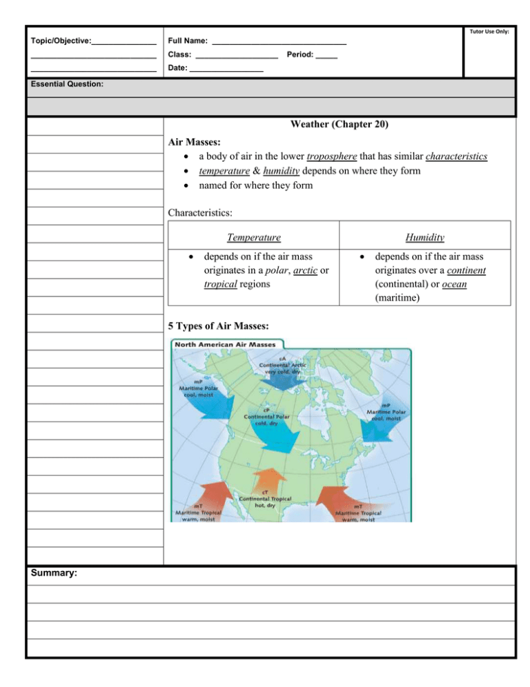
Tutor Use Only: Topic/Objective:_______________ Full Name: _______________________________ _____________________________ Class: ___________________ _____________________________ Date: _________________ Period: _____ Essential Question: Weather (Chapter 20) Air Masses: a body of air in the lower troposphere that has similar characteristics temperature & humidity depends on where they form named for where they form Characteristics: Temperature depends on if the air mass originates in a polar, arctic or tropical regions 5 Types of Air Masses: Summary: Humidity depends on if the air mass originates over a continent (continental) or ocean (maritime) Essential Question: 1. Continental Arctic (cA) extremely extremely cold & dry originates in arctic regions – coldest temperatures NO precipitation 2. Continental Polar (cP) warmer than cA, but only a slight difference in temperature & humidity creates some precipitation creates lake-effect snow around the Great Lakes 3. Maritime Polar (mP) originates over oceans in high latitude cold, damp air mass not as cold as cP because water is water than the land when mP cools to its dew point fog, clouds, and/or precipitation is formed 4. Maritime Tropical (mT) originates over warm, tropical oceans warm, moist air thunderstorms likely to develop 5. Continental Tropical (cT) originates over deserts hot, dry air can exceed 100oF may originate as a maritime tropical but dries out over land Fronts: boundaries between different air masses air masses do not easily mix frontal systems are the cause of weather in the mid-latitudes since this is where air masses mix bring storms and precipitation types & severity of weather depend on the type of air mass and how fast air masses are moving Summary: Essential Question: Four kinds of Fronts: 1. Cold Fronts the boundary between an advancing cold air mass and the warm air mass it is replacing cold air is more dense so it slides under warm air and pushes it up Moves quickly so precipitation doesn’t last long Steep slopes so band of precipitation on ground isn’t wide type of weather depends on type of air it is replacing 2. Warm Fronts the boundary between an advancing warm air mass and the cold air mass it is replacing warm air rises, cold air slowly retreats (slowly pushed on) slope is more gradual than a cold front upper level clouds form first, then lower level clouds weather changes are less dramatic thunderstorms uncommon, prolonged rain and flooding are very common Summary: Essential Question: Warm Front: 3. Stationary Front front that is not moving forward caused because the warm air is not moving fast enough to push the cold air away, the front stalls prolonged precipitation & flooding occur Summary: Essential Question: 4. Occluded Front cold front “catches up” to a warm front warm air is wedged above cold air weather varies, depending on the time of year – usually big storms Severe Weather: Thunderstorms o storms with lightning, thunder, and hail o warm, moist unstable air - cumulonimbus clouds o usually occur in the afternoon or evening because the Earth has been heating up all day o convection within the cumulonimbus clouds gives the storm it’s energy o forms along low pressure systems and cold front boundaries Summary: Essential Question: Summary: Squall Line o line of severe thunderstorms that precede a cold front o bring torrential rains, hail, tornadoes, and lightning Lightning o discharge of electricity from a thundercloud caused by friction o Can occur within a cloud, between clouds, or cloud to ground o positive charge on top and bottom of cloud & negative charge in the middle Tornadoes o violently rotating column of air that usually touches the ground o in order for a tornado to form, there must be a rotating updraft called a mesocyclone o when a tornado has not yet reached the ground it is called a funnel cloud o The Fujita Scale Measures the intensity of a tornadoes using wind speed and damage also called the F-scale Essential Question: o Tornado Alley area of the USA where tornadoes are likely to form; extends from northern Texas to North Dakota warming of the ground and the constant wind in the region are ideal for mesocyclones to form place where warm, moist air from the Gulf of Mexico meets and mixes with cooler, dry air from the west and southwest Storm/Tornado Watches & Warning Summary: WATCHES conditions are favorable for a storm or tornado WARNINGS a severe storm or tornado has been seen and is approaching Hurricanes o large rotating storms of tropical origin that have sustained winds of at least 119 km/h o last for 1+ days o have low pressure centers that draws energy from warm oceans o strongest winds and rain occur around the eye wall o inside the eye, winds are mild with little to no rain o air rises in the eye wall o Formation of Hurricanes need warm, moist air for extended period of time June 1st –November 30th form between 5o – 20o N and S of the equator starts off as a tropical depression and evolve to tropical storms weaken when they make landfall Essential Question: steered by global wind patterns in the Atlantic form off west coast of Africa and move west towards North America o The Saffir-Simpson Scale categorizes hurricanes based on their wind speed and storm surge gives a general idea about impending damage hurricanes change categories throughout their life Summary: Essential Question: o Hurricane Damage a storm surge is when strong eye wall winds blow ocean water into a dome that makes landfall storm surge can raise the sea level several meters higher than normal o Hurricane Watches and Warnings WATCH WARNING a hurricane will arrive in a hurricane will arrive in 24-36 hours less than 24 hours Winter Storms o Snowstorms are storms with steady snowfall o Blizzards are winter storms with heavy snow, winds and low temperatures o 3 criteria must be met for blizzards Winds over 56 kph Temperatures -7oC or lower Reduction of visibility as a result of falling or blowing snow Forecasting Weather Meteorologists collect data to create weather maps & station models Instruments Used o Satellite images o Radiosondes: instruments attached to balloons o Weather stations o Weather radar o Airplanes o Ships Summary: Essential Question: Summary: Information is organized into a station model to be put on a map Station Models o include temperature, dew point, cloud coverage, barometric pressure, wind speed and direction o international symbols so meteorologists around the world can read them Essential Question: Summary: Weather forecasts are based on computer models Computers organize the data from many weather stations Meteorologists draw in the fronts based on temperature, dew point, and wind direction Computers use mathematical equations to make forecasts over the next days to few days Meteorologists edit forecasts based on previous weather patterns for an area and take into consideration urbanization. Urbanization is the tendency for a city to be warmer than the surrounding area based on the fact that buildings hold heat better than vegetation

