Group 14_Vajont Dam.doc
advertisement

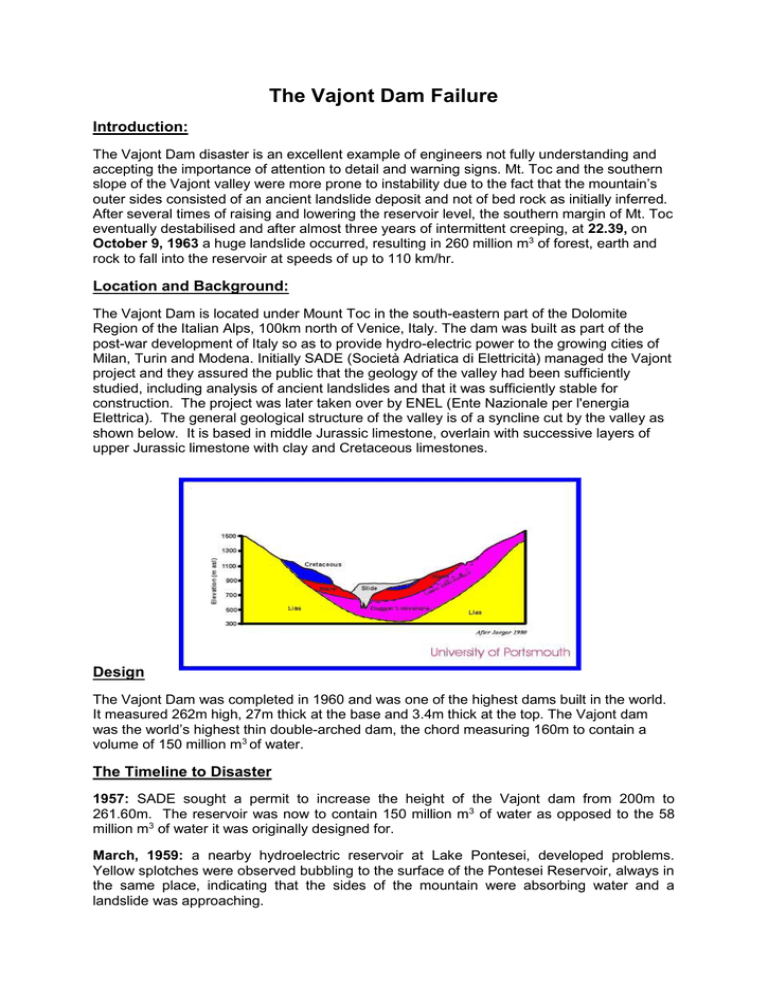
The Vajont Dam Failure Introduction: The Vajont Dam disaster is an excellent example of engineers not fully understanding and accepting the importance of attention to detail and warning signs. Mt. Toc and the southern slope of the Vajont valley were more prone to instability due to the fact that the mountain’s outer sides consisted of an ancient landslide deposit and not of bed rock as initially inferred. After several times of raising and lowering the reservoir level, the southern margin of Mt. Toc eventually destabilised and after almost three years of intermittent creeping, at 22.39, on October 9, 1963 a huge landslide occurred, resulting in 260 million m3 of forest, earth and rock to fall into the reservoir at speeds of up to 110 km/hr. Location and Background: The Vajont Dam is located under Mount Toc in the south-eastern part of the Dolomite Region of the Italian Alps, 100km north of Venice, Italy. The dam was built as part of the post-war development of Italy so as to provide hydro-electric power to the growing cities of Milan, Turin and Modena. Initially SADE (Società Adriatica di Elettricità) managed the Vajont project and they assured the public that the geology of the valley had been sufficiently studied, including analysis of ancient landslides and that it was sufficiently stable for construction. The project was later taken over by ENEL (Ente Nazionale per l'energia Elettrica). The general geological structure of the valley is of a syncline cut by the valley as shown below. It is based in middle Jurassic limestone, overlain with successive layers of upper Jurassic limestone with clay and Cretaceous limestones. Design The Vajont Dam was completed in 1960 and was one of the highest dams built in the world. It measured 262m high, 27m thick at the base and 3.4m thick at the top. The Vajont dam was the world’s highest thin double-arched dam, the chord measuring 160m to contain a volume of 150 million m3 of water. The Timeline to Disaster 1957: SADE sought a permit to increase the height of the Vajont dam from 200m to 261.60m. The reservoir was now to contain 150 million m3 of water as opposed to the 58 million m3 of water it was originally designed for. March, 1959: a nearby hydroelectric reservoir at Lake Pontesei, developed problems. Yellow splotches were observed bubbling to the surface of the Pontesei Reservoir, always in the same place, indicating that the sides of the mountain were absorbing water and a landslide was approaching. Also in 1959: cracks developed on the Mount Toc side of the valley, as a result of the construction of a ring road around the reservoir. The builders were instructed to fill in the cracks and continued on working but the cracks reappeared. The chief engineer, Dr. Semenza then requested a survey of the area. From this survey, it was concluded that the Mount Toc side of the valley was a prehistoric landslide and was in the process of moving down Mount Toc. Further studies indicated that the ancient landslide was stable but would eventually creep down the valley. SADE, however, decided that a deep-seated landslide was highly unlikely and informed the public that the dam was sufficiently stable because: three test borings had failed to identify any areas of weakness it was assumed that any shear plane would have a 'chairlike' form that would exert a 'braking effect' analysis using seismic reflection profiling had suggested that the banks consisted of very firm in-situ rock with a high elastic modulus (thus is very stiff and makes it less likely to fail under a compressive/tensile load) January 2, 1960: SADE completed the Vajont Dam and proceeded to the testing phase. This involved impoundment of various amounts of water to about halfway up the dam. At the same time, Italy decided to nationalise its hydroelectric industry and as a result, SADE decided to raise the water level to 660m (as opposed to the allowed 600m) above sea-level. However, they realised that the more the water level rose, the more the foot of the creep zone moved, resulting in yellow/brown bubbles being sent to the surface of the reservoir (similar to Pontesei). An indication that a landslide was imminent! March 1960: The increasing water level resulted in a small rupture. October 1960: A further increase in the water level to 170m lead to an increase in the rate of movement to approximately 3.5cm/day. November 1960: 700,000 m3 of rock slid down into the reservoir in the space of 10 minutes, resulting in a giant wave. Also a metre-wide crack appeared, high up the mountain. Seismographs were then installed on top of the dam to assess displacements. The level of the reservoir was then gently dropped back to 135m above river level and the movement reduced to close to 1mm/day. In the meantime, a bypass tunnel was constructed under the reservoir, so that it could still produce hydroelectric power, if the landslide was to occur. December 1961: A second test was organised by the government, which involved the impoundment of water to an even higher level. As the water level increased, the seismographs at the top of the dam began to set off two out of every three days. As a result, on October, 1962, all the water was drained out of the reservoir and the mountain settled down again. The engineers now understood that control of the landslide was possible by altering the water level of the reservoir. March 14, 1963: the Vajont project was passed to ENEL (National Energy Agency). Because a required third impoundment had not taken place, SADE received six days temporary custody of the project to bring the water level to 715m above sea level, despite the fact that they were informed in the early phase of the design process to never exceed 700m above sea level else the dam might fail. This water level was maintained through early September, 1963, and the rates of displacement increased to as much as 3.5cm/day. ENEL, took over complete ownership of the project and by the end of August, 1963, the water level reached 710m above sea level. September 2, 1963: An earthquake (Grade 7 on the Mercalli Scale) occurred at Mount Toc. This was followed by another tremor on September 15, 1963. The new chief engineer, Biadene, insisted that the situation was under control. September 17, 1963: the engineers turned off the water entering the dam for a week to help stabilise the rate of creep. Although the water level was stationary, Mount Toc continued to slide. Removal of the water would be catastrophic as would leaving the body of water in the reservoir. By now, the velocity of displacement was up to 20cm/day, but instead of informing the public, the chief engineer said nothing. The people in Erto were told to “remain alert” by the police. At 22.39 on October 9, 1963, the landslide occurred. It slid approximately 500m northwards with speeds up to 30m/second. The mass of material completely blocked the valley to a depth of up to 400m and it travelled up to 140m on the opposite side. The landslide lasted for approximately 45 seconds. At the time, the reservoir contained 115 million m 3 of water. A tsunami wave then moved upstream (up the opposite side of the valley) and destroyed the village of Casso, before overtopping the dam by up to 245m. The foul-smelling mass of water, approximately 30 million m3, preceded by a roaring wind, destroyed the villages of Longarone, Pirago, Villanova, Rivalta and Fae and killed 2,500 people. However the dam was not destroyed in the landslide and is still standing today. Conclusions There are various different suggestions as to why this disaster occurred: reactivation of an old landslide a completely new landslide increasing the level of the reservoir drove up pore pressures in the clay layers, reducing the effective normal strength and hence the shear resistance contribution of rainfall, dam level changes and earthquakes as triggers of the landslide Resistance to movement was created by the chair-like form of the shear surface. Dropping the level of the reservoir induced hydraulic pressures that increased the stresses as water in the jointed limestone tried to drain. The profit motive and capitalism have been blamed for cutting corners in the building of the dam After researching this disaster it was clear to see that all the warning signs were there, years in advance. The engineers chose to ignore these signs and not to warn the nearby villages. The chief engineer needed to swallow his pride and admit defeat. Our group have learned an important lesson from this, that in the engineering world it is far better to be safe than sorry!


![R14 Vajont_Dam_failure[1].doc](http://s2.studylib.net/store/data/015465365_1-3d807b5ec39cbbbef8455e573e06f568-300x300.png)


