RM 127
advertisement
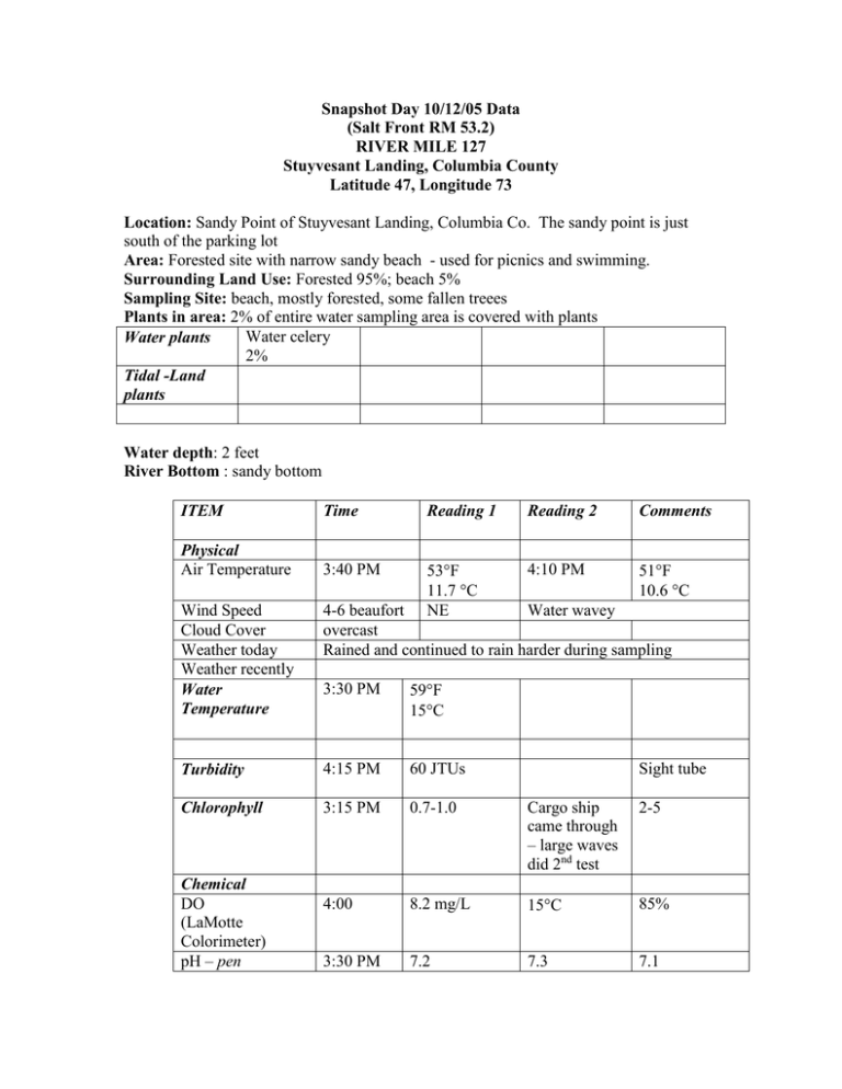
Snapshot Day 10/12/05 Data (Salt Front RM 53.2) RIVER MILE 127 Stuyvesant Landing, Columbia County Latitude 47, Longitude 73 Location: Sandy Point of Stuyvesant Landing, Columbia Co. The sandy point is just south of the parking lot Area: Forested site with narrow sandy beach - used for picnics and swimming. Surrounding Land Use: Forested 95%; beach 5% Sampling Site: beach, mostly forested, some fallen treees Plants in area: 2% of entire water sampling area is covered with plants Water celery Water plants 2% Tidal -Land plants Water depth: 2 feet River Bottom : sandy bottom ITEM Time Reading 1 Reading 2 Comments Physical Air Temperature 3:40 PM 53F 11.7 C NE 4:10 PM 51F 10.6 C Wind Speed Cloud Cover Weather today Weather recently Water Temperature 4-6 beaufort Water wavey overcast Rained and continued to rain harder during sampling 3:30 PM 59F 15C Turbidity 4:15 PM 60 JTUs Chlorophyll 3:15 PM 0.7-1.0 Cargo ship came through – large waves did 2nd test 2-5 4:00 8.2 mg/L 15C 85% 3:30 PM 7.2 7.3 7.1 Chemical DO (LaMotte Colorimeter) pH – pen Sight tube Phosphate Nitrate 4:05 PM 4:10 PM 0.11 ppm 0.00 Alkalinity Salinity Fish Catch 4:07 PM 82 ppm Number Caught Species Tides 3:30 Pm 4:30 PM Falling Falling slowly South Ebbing 3:15 PM Cargo freighter Possible operator error CPUE Seine Industrial Champ Intermarine Flock 3 ~ 20 geese on water Nourthbound Currents Traffic Other Items Core Flock 1 ~ 80 geese flying S Flock 2 ~ 50 geese – flying S Light
