Snapshot Day 10/7/08 Data (Salt Front RM 63.4) RIVER MILE -11
advertisement
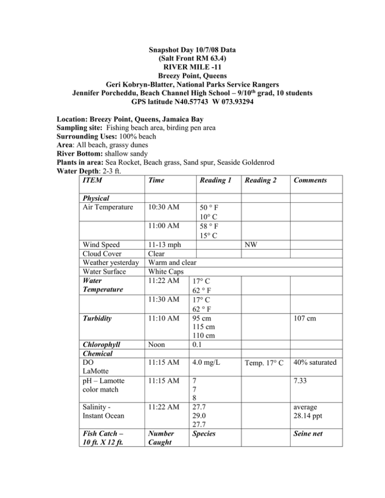
Snapshot Day 10/7/08 Data (Salt Front RM 63.4) RIVER MILE -11 Breezy Point, Queens Geri Kobryn-Blatter, National Parks Service Rangers Jennifer Porcheddu, Beach Channel High School – 9/10th grad, 10 students GPS latitude N40.57743 W 073.93294 Location: Breezy Point, Queens, Jamaica Bay Sampling site: Fishing beach area, birding pen area Surrounding Uses: 100% beach Area: All beach, grassy dunes River Bottom: shallow sandy Plants in area: Sea Rocket, Beach grass, Sand spur, Seaside Goldenrod Water Depth: 2-3 ft. ITEM Time Reading 1 Reading 2 Physical Air Temperature 10:30 AM 11:00 AM Wind Speed Cloud Cover Weather yesterday Water Surface Water Temperature Turbidity Chlorophyll Chemical DO LaMotte pH – Lamotte color match 50 F 10 C 58 F 15 C 11-13 mph Clear Warm and clear White Caps 11:22 AM 17 C 62 F 11:30 AM 17 C 62 F 11:10 AM 95 cm 115 cm 110 cm Noon 0.1 NW 11:15 AM 4.0 mg/L Temp. 17 C 11:15 AM 7 7 8 27.7 29.0 27.7 Species Salinity Instant Ocean 11:22 AM Fish Catch – 10 ft. X 12 ft. Number Caught Comments 107 cm 40% saturated 7.33 average 28.14 ppt Seine net seine/1 pull 6 Tides 1 2 cm 1.5 cm 10:30 AM 10:45 AM 11:00 AM 11:15 AM 11:32 AM Atlantic Silversides Kingfish Comb jellies Mole Crab 10 cm 14 cm 20 cm 31.3 cm 36 cm Rising Rising Rising Rising Rising Currents CoreNoon Water depth 4 ft, Shipping Journal 8m/60secs 16m/120 secs 24m/180 secs 22 cm total length 8 cm top 15 cm bottom 10:30 AM 13.33 cm/sec Abundant – mud on the bottom Sand & Gravel on top North North Flood Flood North Flood Common– Pebbles Fine grain bottom & larger grain top, pea size gravel on top Worm inside Small pleasure Southbound boat 11:00 AM Fishing Boat Northbound 11:30 AM DEP Boat Northbound It was a clear day and quite breezy. Good thing the students were wearing chest waders. After an hour or so it was difficult to write, student hands were frozen. Hardly caught anything in the seine net, better luck next year!
