Ground water modeling coupled with SVTA model
advertisement
II-261
土木学会第57回年次学術講演会(平成14年9月)
Ground water modeling coupled with SVTA model
and its application to Yasu River Basin
DPRI, Kyoto University Student Member
DPRI, Kyoto University Member
DPRI, Kyoto University Member
1.
Kimaro, T.A
Tachikawa, Y
Takara, K
changes on groundwater resources
applied to estimate recharge.
Introduction
Preliminary study of ground water levels in the
lower Yasu River basin indicates that some
parts of the basin have experienced significant
draw down in the ground water levels. Among
the 10 sites where ground water was available
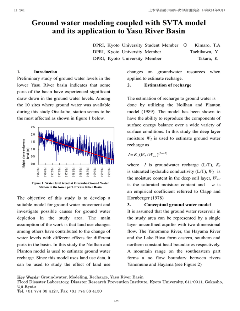
during this study Otsukubo, station seems to be
the most affected as shown in figure 1 below.
2.
when
Estimation of recharge
The estimation of recharge to ground water is
done by utilizing the Noilhan and Planton
model (1989). The model has been shown to
have the ability to reproduce the components of
surface energy balance over a wide variety of
surface conditions. In this study the deep layer
moisture W2 is used to estimate ground water
2.5
2.0
1.5
recharge as
1.0
I = K s (W2 / Wsat ) ( 2 a +3)
0.5
where I is groundwater recharge (L/T), Ks
is saturated hydraulic conductivity (L/T), W2 is
the moisture content in the deep soil layer, Wsat
is the saturated moisture content and
a is
an empirical coefficient referred to Clapp and
Hornberger (1978)
1996/1/1
1993/1/1
1990/1/1
1987/1/1
1984/1/1
1981/1/1
1978/1/1
1975/1/1
1972/1/1
1969/1/1
0.0
1966/1/1
Height above reference
level (m)
{
Figure 1: Water level trend at Otsukubo Ground Water
Station in the lower part of Yasu Riber Basin
The objective of this study is to develop a
suitable model for ground water movement and
investigate possible causes for ground water
depletion in the study area. The main
assumption of the work is that land use changes
among others have contributed to the change of
water levels with different effects for different
parts in the basin. In this study the Noilhan and
Planton model is used to estimate ground water
recharge. Since this model uses land use data, it
can be used to study the effect of land use
3.
Conceptual ground water model
It is assumed that the ground water reservoir in
the study area can be represented by a single
layer unconfined aquifer with two-dimensional
flow. The Yanomune River, the Hayama River
and the Lake Biwa form eastern, southern and
northern constant head boundaries respectively.
A mountain range on the southeastern part
forms a no flow boundary between rivers
Yanomune and Hayama (see Figure 2)
Key Words: Groundwater, Modeling, Recharge, Yasu River Basin
Flood Disaster Laboratory, Disaster Research Prevention Institute, Kyoto University, 611-0011, Gokasho,
Uji Kyoto
Tel. +81-774-38-4127, Fax +81-774-38-4130
-521-
II-261
土木学会第57回年次学術講演会(平成14年9月)
to define the aquifer system in order to quantify
water level changes.
4.
Mathematical model
The governing equation applied to model
groundwater flow in this case is the Boussinesq
equation. When pumping and leakage term are
introduced this equation can be stated as
∂/∂x(Kxb∂h/∂x) +∂/∂y(Kyb∂h/∂y) =
S∂h/∂t + q(x,y) - Kz/2M(x,y)(2Ho – ht – ht+1)
where Kx, Ky and Kz are permeabilities in
X ,Y and Z directions [L/T], b is the saturated
aquifer thickness [L] and q(x,y) is pumping or
recharge rate (L3/T). M(x,y) and Ho(x,y) are
the thickness and hydraulic head of the
confining layer respectively.
Figure 2 boundaries of study area
5.
Model application
The study area is located in the lower part of
the Yasu River basin near Lake Biwa. The area
has about 67 production wells with a total
pumping load of 111778 ton/day and 10
observation wells. Initial conditions for
groundwater model were estimated by Kriging
technique utilizing observed water levels from
the 10 observation wells. The ground water
recharge is estimated prior to groundwater
simulation.
Figure 3 Initial ground water level contours
6.
Results and discussions
A test run for the ground water model was
conducted. At the preliminary stage only the
response to pumping is investigated. The result
indicates that the model can simulate well the
response to pumping. It is also seen that
groundwater abstractions can play a major role
in changing the direction of groundwater flow
as seen in comparison of initial and final
groundwater contours. This will in future with
more realistic data give clue to how pumping in
wells can affect the ground water levels over
the study area. However more data is required
Figure 4 Ground water level contours after
one-day simulation
References:
1) J. Noilhan and S. Planton 1988: simple
parameterization of land surface processes
for Meteorological models. Mon. Wea. Rev.
117, 537-549.
2) Clapp, R. B., and G. M. Hornberger, 1978:
Empirical equations for some soil hydraulic
properties. Water Resor. Res., 14, 601-604
-522-


