RAINFALL-RUNOFF CHARACTERISTICS OF SMALL CATCHMENTS IN SEMIARID

Ⅱ−26 第36回土木学会関東支部技術研究発表会
RAINFALL-RUNOFF CHARACTERISTICS OF SMALL CATCHMENTS IN SEMIARID
REGION OF TUNISIA: HYDROMED DATA QUALITY
I. INTRODUCTION
Water shortage is a major concern in Tunisia as well as the most of the Mediterranean countries, which are situated in the arid and semiarid climatic zone where the mean annual rainfall does not exceed 550 mm. Moreover, the semiarid climate is characterized by a very erratic rainfall pattern, drought, poor vegetation cover, severe soil loss and violent erosion during the flood season. An amount equal to the annual mean can be recorded in a single rainfall event and large floods are often observed. Due to this, analyzing rainfall-runoff characteristics in this area is one of the most challenging subjects of hydrologists.
In the beginnings of the 1990s, the Tunisian government launched an ambitious program for constructing small hillside reservoirs in the northern and central region of the country. The idea is to stimulate the local agriculture. However, with both the intensive irregular rainfall and severe soil erosion, the lifetime of these hydraulic structures is in jeopardy.
Flash floods with high sediment load are threatening many of these reservoirs and some of them have already been filled up with sediment in less than 10 years (after construction).
In 1993, a network for studying and observing over thirty small hillside catchments in the semiarid region of Tunisia was set up to form a hydrological database. In 1996, HYDROMED research project, led by IRD (Institut de Recherche pour le développement, ex-ORSTOM) and financed by the European Union, selected several sites for pilot schemes in countries of the Mediterranean periphery: Lebanon, Morocco, Syria and Tunisia. The main objective of this project was to build a hydrological model suitable for semiarid
Mediterranean catchments with hill reservoirs (Ragab
2001a).
The aim of this study is rainfall-runoff characterization of hillside reservoir catchments in the semiarid region of Tunisia. For that purpose, twenty two small hillside catchments were chosen because other data was not available. A systematic review of
HYDROMED data has been undertaken to assess the quality of the existing data-set and to understand the hydrological behavior in the semiarid region of
Tunisia.
II. STUDY AREA AND HYDROMED DATABASE
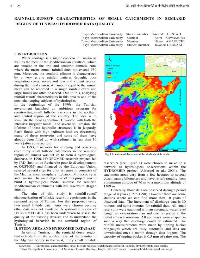
In central Tunisia, in the semiarid dorsal region that extends from the northern east of the country to the Algerian border in the west, thirty small hillslide
Tokyo Metropolitan University Student member ○ Achraf HENTATI
Tokyo Metropolitan University Member Akira KAWAMURA
Tokyo Metropolitan University Member Hideo AMAGUCHI
Tokyo Metropolitan University Student member Takanori OKASAKI
Fig.1
Location of Tunisia and the studied catchments. reservoirs (see Figure 1) were chosen to make up a network of hydrological observations within the
HYDROMED project (Albergel et al., 2004). The catchment areas vary from a few hectares to several dozen square kilometers and have reliefs ranging from a minimum altitude of 70 m to a maximum altitude of
1309 m.
Generally, those data are observed during a period range of 4 years (1995-1998). However there are some stations where we can find more than 10 years of observed data. The increment of discharge data is 30 minutes and some minutes for rainfall data. All small reservoirs were equipped with an automatic water level gauge, an evaporation pan and one raingauge at the outlet of each reservoir. All spillways were shaped in such a way that discharge could be estimated. The rainfall measurements were made by tipping bucket raingauges which are fully automatic and data are downloaded once a month through data loggers. The capacity of tipping bucket is 0.5 mm of rainwater. The
Keyword: Hydrological characteristics, small hillside reservoir catchments, semiarid, Tunisia, HYDROMED data quality
Tokyo Metropolitan University , 1-1 Minami-Ohsawa, Hachioji, Tokyo 192-0397, Japan . E-mail:achraf-hentati@ed.tmu.ac.jp
Ⅱ−26 第36回土木学会関東支部技術研究発表会 rainfall observation system was designed to give reliable rainfall estimates down to at least 1-min values.
Time is recorded every second. Therefore, rainfall amounts and intensities can be computed with great accuracy.
When there is no gauge at the inlet of a reservoir, the inflow by the surface runoff can be estimated from change in the reservoir level, and therefore the volume, using the stage-volume curve. When the spillway flow takes place, the catchment is assumed to be, at or close, saturation. In such cases the inflow to the reservoir by surface runoff becomes equal to the outflow of the reservoir as spillway flow.
III. METHEDOLOGY
First we prepared the rainfall and runoff input files to be processed by a self-developed tool for the selection of rainfall and runoff events. Since the rainfall storms are infrequent in semiarid climate, we assumed one day for the separation of those events.
Rainfall were cumulated every 10-min interval.
After analyzing 139574 rainfall records and
109165 runoff records of the twenty two studied watersheds, 6151 hyetograms and 3520 hydrographs were identified. Hydrographs and hyetograms were synchronized and graphically created and some values such as the total rainfall and total discharge, duration, hydrograph peak and rainfall peak and rainfall-runoff ratio were calculated for each event and stored in output files.
IV. RESULTS AND DISCUSSION
Figure 2 shows all of the rainfall and corresponding runoff data for each of the twenty two basins. The rainfall-runoff coefficients were calculated for separate rainfall-runoff events. Lines of constant rainfall-runoff ratio after an initial loss have been added to the plot for reference. The initial loss appears
260
240
220
200
180
160
140
120
100
80
60
40
20
6
8
2
4
10
12
14
16
18
20
26
Linear (19)
Linear (21)
Y
21
= 0.326X
21
- 3.2613
R2 = 0.4818
7
9
3
5
11
13
15
17
19
21
30
Linear (17)
Y
17
= 0.1162X
17
- 0.5228
R2 = 0.5357
Y
19
= 0.0574X
19
- 0.5594
R2 = 0.8085
0
0 20 40 60 80 100 120 140 160 180 200 220 240 260
Rainfall (mm)
Fig.1
event-based rainfall-runoff ratio for the 22 studied watersheds. to be in the 0.5 - 3.5 mm range, and is to be expected due to the factors such as, depression storage and high infiltration rates. The rainfall-runoff ratio ranges from close to 0 to about 0.4.
This plot shows a significant variability in response across each basin. Additional scatter due to data error and variance in initial moisture conditions would also be expected. As it was aforementioned in this study, the runoff data was estimated from the reservoir level change. Because of the wind, lag and resolution of the depth recorder, problems of siltation in the reservoirs and unrecorded releases for irrigation, the runoff cannot be accurately quantified (Ragab,
2001b). In addition to the runoff estimation error, another possible reason for the scatter that is seen on the Figure 2 for each of these basins is the variation in antecedent moisture across the basin. If the basin had recently seen large runoff response, some of the initial loss may be reduced and infiltration capacity reduced.
Accounting for antecedent moisture over large natural basins is difficult, especially with the available data.
We also noticed in the case of those semiarid watersheds that even storms greater than 100 mm may produce only a few millimeters of runoff. This complex variability is also a function of the antecedent moisture of the catchments.
V. CONCLUSION
Generally, the analysis of the available rainfall and runoff records for twenty two small watersheds in semiarid region of Tunisia shows a significant amount of scatter, both across the watersheds and for multiple events at a single watershed. Some of this scatter is differences in antecedent moisture. Other reason is inaccuracy in the estimation of the runoff data.
Moreover these results highlighted the need for more recording instrumentation and more raingauges and long term records with large numbers of significant events that are able to generate spillway flow to obtain more consistent and reliable runoff values.
REFERENCES
Albergel, J., Nasri, S., Boufaroua, M., Droubi, A.,
Merzouk, A. A. 2004: Rain water harvesting and management of small dams in Mediterranean areas
(North Africa and Middle East), Conference in Ohrid ,
FY Republic of Macedonia, 25-29, 1-12, May 2004.
Ragab, R., Austin B. and Moidinis D. 2001: a) The
HYDROMED model and its application to semi-arid
Mediterranean catchments with hill reservoirs: The rainfall-runoff model using a genetic algorithm for optomisation, Hydrology and Earth System Sciences.
Vol.5, 543-553.
Ragab, R., Moidinis, D., Albergel, J., Khouri, J., Drubi.
A. and Nasri., S. 2001: b) The HYDROMED model and its application to semi-arid Mediterranean catchments with hill reservoirs: Rainfall-runoff model applications to three Mediterranean hill reservoirs,
Hydrology and Earth System Sciences.
Vol.5, 554-562.


