Here Or There Is Where? Haptic Egocentric Interaction With Topographic Torch
advertisement

Here Or There Is Where? Haptic Egocentric Interaction
With Topographic Torch
Mike Bennett 1
Sile O’Modhrain 2
Systems Research Group 1
School of Computer Science and Informatics,
UCD Dublin, Belfield,
Dublin 4, Ireland
{mike.bennett, aaron.quigley}@ucd.ie
Aaron Quigley 1
Sonic Arts Research Centre 2
Queen’s University of Belfast,
Belfast BT7 1NN,
Northern Ireland
sile@qub.ac.uk
ABSTRACT
In this paper we present and describe Topographic Torch; a
handheld digital mapping tool featuring a novel egocentric
interaction model. Topographic Torch was designed to
encourage and enable people to explore spatial relationships
of the world around them in a “natural” manner. Users of
Topographic Torch can physically point at objects of
interest in the world to automatically see those objects on a
map. Enabling people to physically point at objects of
interest forces them to use their location in the world as an
egocentric frame of reference. An egocentric frame of
reference may enhance people’s ability to understand the
relationships between where they are in the world and
where other objects of interest are in relation to them. We
describe Topographic Torch’s interaction model and
elaborate on how it functions, along with an outline of a
preliminary user study.
Author Keywords
Egocentric Interaction, Embodied Interaction, Haptics,
Spatial Cognition, Wayfinding, Maps, Zoomable Displays,
Handheld Devices
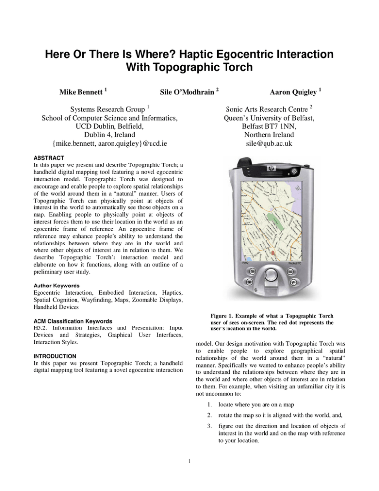
Figure 1. Example of what a Topographic Torch
user of sees on-screen. The red dot represents the
user’s location in the world.
ACM Classification Keywords
H5.2. Information Interfaces and Presentation: Input
Devices and Strategies, Graphical User Interfaces,
Interaction Styles.
model. Our design motivation with Topographic Torch was
to enable people to explore geographical spatial
relationships of the world around them in a “natural”
manner. Specifically we wanted to enhance people’s ability
to understand the relationships between where they are in
the world and where other objects of interest are in relation
to them. For example, when visiting an unfamiliar city it is
not uncommon to:
INTRODUCTION
In this paper we present Topographic Torch; a handheld
digital mapping tool featuring a novel egocentric interaction
1
1.
locate where you are on a map
2.
rotate the map so it is aligned with the world, and,
3.
figure out the direction and location of objects of
interest in the world and on the map with reference
to your location.
Previous work, particular in psychology, has shown that
there are a number of ways of navigating and understanding
spaces, i.e. survey, procedural and landmark knowledge [9,
10, 11]. Most of these variations can be viewed as
differences in the frames of reference used for navigating
spaces, i.e. relative, egocentric, and intrinsic frames of
reference [4, 8].
Levine [6, 7] explored the implications of these differences
for map reading and design. The results of this were a
number of experiments that lead to the following principles
about map design [2]:
Figure 2. Representation of how the viewport
rotates around the user in Topographic Torch.
Point A is the location of the user in the world,
Point B is the region of the map shown on-screen,
Point C is a region of the map that is shown after
user rotation. r is the radius of the circle around
which B moves when the user rotates on the spot.
1.
Alignment Principle, maps should be aligned with
the world they represent.
2.
Forward-Up Principle, the upward direction of the
map should correspond to what is in front of the
person using the map.
3.
Two-Point Theorem, a person should be able to
relate two points in the world to two points on the
map.
In Topographic Torch each of Levine’s principles are
employed in the context of an egocentric frame of
reference.
TOPOGRAPHIC TORCH
Interaction Model
When using Topographic Torch people can physically point
at objects of interest in the world, such as distant buildings,
and see where those objects are on a map in relation to
where they are.
Topographic Torch is a handheld tool, consisting of an iPaq
PDA (Personal Digital Assistant) running custom
developed software.
Using Topographic Torch can be thought of as similar to
using a handheld torch in a dark room. With a handheld
torch you can point in various directions to shed light on
areas of interest, with limitations on how far the beam of
light will travel. A second way of thinking about
Topographic Torch is as a tool for carrying out “Point-andQuery” interactions with the world and data overlaid on the
world. An important aspect of Topographic Torch is that
actions, e.g. pointing, are carried out with reference to the
location of the person in the world (embodied interaction).
Users are presented with a map on the PDA screen (Figure
1). The map is centered on the location where the user is
standing in the world (Figure 2, Point A). The map is
initially displayed at a level of zoom such that streets and
street names can be readily identified. A user does not press
buttons or adjust sliders to interact with the map. Movement
around and explorations of the map are controlled in two
separate though related ways. The two ways of moving
around the map are by pointing and tilting. By moving
around the map the user is able to see different parts of the
map in the viewport, i.e. on the PDA screen.
BACKGROUND & RELATED WORK
Maps displayed on handheld devices are increasingly used
in variety of contexts for wayfinding tasks, e.g. where is the
nearest supermarket, what is the shortest route from
location A to location B, etc. Yet there are a number of
serious challenges with using these maps [1, 2, 4]. Limited
screen sizes of handheld devices restrict how much of a
map can be displayed to the user at any one time. Small
display sizes make it harder to understand the spatial
relationship between two points on a map, i.e. if the two
points are far enough apart they cannot be simultaneously
displayed on screen [6]. An inability to see different parts
of the map at once, especially multiple points of interest,
restricts a person'
s ability to understand spatial
relationships.
Pointing
To use Topographic Torch the user holds the PDA so that
the screen is reasonably parallel with the surface of the
Earth. Then the user points the PDA in any direction, e.g.
North, South, East or West. This causes the map to
automatically rotate around the point where the user is
located in the world (Figure 2, Point A). Rotation stops
when the map is properly aligned with the world. For
example when a user physically points North the on-screen
map will update to show what is North of the user (Figure
2, anywhere along line r).
Topographic Torch’s automatic alignment means users do
not have to physically or mentally rotate maps. All
Distant-Dependent Automatic Zooming (DDAZ)
alignment is done with regards to the user’s physical
location, i.e. an egocentric frame of reference. Therefore
Levine’s Alignment Principle automatically occurs as part
of the fundamental design of Topographic Torch.
As the user looks at regions of the map that are further and
further away from them the map is automatically zoomed
out. They can see less detail but more overview. As they
look at regions closer and closer to their location the map
zooms in more and more. They can see more detail but less
overview. This is done for a number of reasons. DistantDependent Automatic Zooming can be viewed as a
variation of Speed-dependent Automatic Zooming [5]
Tilting
Tilting the PDA scrolls the on-screen map backwards and
forwards along the direction the user is pointing in (Figure
2, line r). To scroll forward the user tilts the device forward,
and to scroll backwards the user tilts the device backwards.
When tilted forward the PDA should be angled such that
the front of the device becomes closer to the ground, and
the back of the device becomes further away from the
ground. It is not possible for a user to scroll so far back they
begin to see what is behind them. A user can only scroll
back to where they are located on the map. If they wish to
see what is behind them they must turn around and point in
that direction. Unlike other digital maps pressing left or
right buttons, or tilting left or right in the case of
Topographic Torch, has no effect – it does not cause the
map to scroll left or right. Tilting enables users to explore
parts of the map that can be physically distant and offscreen.
Firstly it is done to try and build on how we see objects in
the world. We are unable to see distant objects as clearly as
we can see close objects, e.g. buildings, and distant objects
can appear smaller than close objects. By dynamically
altering the scale and level of detail as a function of
distance (length of r) we are attempting to influence a user’s
sense of the distance between where they are and where
what they are looking at is.
Secondly, as a user looks at parts of the map that are further
and further away the sensitivity of pointing increases. As r
increases in length then the distance traveled per degree
around the circle circumference increases. A one degree
change in the direction a user is pointing, when looking at
regions of the map that are close by, does not traverse a
large amount of the map. A one degree change when r is
large causes large amounts of the map to be traversed.
Therefore when r is large there are two potential negative
effects:
Tilting, as implemented in Topographic Torch,
automatically fulfills Levine’s Forward-Up principle. What
the user sees on-screen is always in front of the direction
the user is pointing in.
Egocentric Scrolling
With the interaction model described so far an important
question is: What would happen if a user rotates/points in
different directions when the region of the map at Point B
in Figure 2 is displayed on-screen? In existing mapping
tools a user would expect to see what is directly to the left
or right of Point B, i.e. the on-screen map would scroll left
or right. This is not the case with Topographic Torch
because scrolling and movement around the map are tightly
integrated with where the user is located in the world.
Instead user rotation causes the viewport, which is initially
at Point B, to traverse the circumference of a circle. The
centre of the circle is Point A, where the user is located in
the world, and the radius of the circle is the distance
between Point A and Point B. As a user tilts forward and
back the radius r increases or decreases. For example in
Figure 2 if the user is facing North (Point B), and then
rotates approximately 50 degrees right they would see the
region of the map at Point C.
1.
Slight changes in the direction the user is pointing
cause very large changes in what is shown onscreen, thus any kind of small physical jitter or
movement by the user leads to a constantly
updating unreadable screen display.
2.
If the user is trying to explore the area around a
point, then a small change in pointing angle leads
to a large amount of the map getting traversed.
This makes it hard to understand the relationship
between regions of the map, because there is no
visual scrolling continuation between the regions.
By using DDAZ in Topographic Torch we prevent these
two potential issues. By zooming out as r increases the rate
of traversal around the circumference of the circle can be
maintained as a fixed rate of movement.
IMPLEMENTATION DETAILS
Topographic Torch runs on an iPaq plugged into a MESH
[3]. MESH is a hardware platform for the iPaq that captures
a wide range of haptic information. MESH has X, Y, and Z
axis magnetic compasses, gyroscopes and accelerometers,
and a number of other very useful features, e.g. vibro-tactile
feedback, GPS, etc. The magnetic compass and the
accelerometer are used for carrying out tilt compensation to
establish what direction Topographic Torch is being
pointed in. Tilt compensation adjusts the magnetic compass
data so that the direction of magnetic North is not lost when
Topographic Torch is tilted. For example if you tilt a
It should be noted that the viewport rotates as well. The
viewport maintains a tangent to the circle while traversing
the circumference of the circle. By maintaining the
viewport at a tangent to the circle scrolling will always
occur from the top to the bottom or from the bottom to the
top of the screen. This top to bottom scrolling is important
to do because it maintains Levine’s Forward-Up Principle
for user interactions with maps.
3
traditional magnetic compass too much the compass needle
gets stuck and provides incorrect directional information.
Low pass filtering is carried out on the data captured from
MESH. This reduces the jitter introduced by the users’
kinesthetic system and contributes to making display
updates smoother. Maps are stored as bitmaps, though
vector based maps would be better for the map transforms,
i.e. zooms and rotations.
PRELIMINARY STUDY
We have carried out a preliminary study of Topographic
Torch. The purpose of the study was to provisional examine
whether Topographic Torch helped users understand the
relationship between where they are in the world and where
various target locations were. Is angular error greater or less
with Topographic Torch when a user had to understand the
relationship between two points in the world and on a map?
Angular error is defined as the difference in degrees
between the direction a user thinks a location is in and what
direction it actually is in. A secondary purpose of the study
was to establish how to experimental examine Topographic
Torch.
There were two groups in the experiment, with four
subjects taking part. Group 1 carried out the tasks using a
paper based map, and Group 2 carried out the tasks using
Topographic Torch. Both maps were the same. In both
Groups the subjects stood in the same fixed location. There
were two main tasks. Task 1 was a timed task which
consisted of pointing in a specific direction and asking
users to find a specific location in that direction. In Task 2
users were given a target on a map, and then asked to
indicate the direction of the target in the real world relative
to their location. Though the number of subjects is not large
enough to draw meaningful conclusions it would seem that
Topographic Torch subjects faired better at Task 2, while
paper based map subjects were faster at Task 1.
After the experiment we informally exposed all subjects,
along with number of others, to Topographic Torch. In
general users appeared to quickly understand how pointing
Topographic Torch would automatically align the map, and
how tilting backward and forwards scrolled the viewport
along the direction they were facing. A number of these
users initially kept on tilting Topographic Torch left and
right to scroll left and right. Even though they did
understand how Topographic Torch worked they took time
to adjust to the idea of rotating their whole body to point in
directions of interest. This may indicate the egocentric
frame of reference in Topographic Torch is not something
everyone immediately adapts to.
CONCLUSION
In this paper we have presented a novel egocentric mapping
reading tool. Motivations for the interactive design
decisions behind Topographic Torch have been covered
while touching on how these decisions meet Levine’s map
design principles. The impact of maintaining an egocentric
frame of reference in each of the interactions is covered.
The impact of the egocentric frame of reference for
interactive design can be especially seen in the DistantDependent Automatic Zooming and the Egocentric
Scrolling.
ACKNOWLEDGMENTS
Thanks to Ken Haase and Stephen Hughes for their
suggestions and help. A portion of this research was carried
out while the first two authors worked at Media Lab
Europe.
REFERENCES
1. Baudisch, P., and Rosenholtz, R. Halo: A Technique for
Visualizing Off-Screen Locations. In Proc. CHI 2003,
481-488, 2003.
2. Darken, R. P., and Sibert, J. L. Navigating Large Virtual
Spaces. In International Journal of Human-Computer
Interaction, 8(1), 49-72, 1996.
3. Hughes, S., Oakley, I., and O’Modhrain, S. MESH:
Supporting Mobile Multi-modal Interfaces. Presented at
ACM UIST 2004, Sante Fe.
4. Hunt, E., and Waller, D. Orientation and wayfinding: A
review. ONR technical report N00014-96-0380,
Arlington, VA: Office of Naval Research, 1999.
5. Igarashi, T., and Hinckley, K. Speed-dependent
automatic zooming for browsing large documents. In
Proc. UIST 2000, 139-148.
6. Levine, M., Jankovic, I. N., and Palij, M. Principles of
Spatial Problem Solving. Journal of Experimental
Psychology: General, 111(2), 157-175, 1982.
7. Levine, M., Marchon, I., and Hanley, G. The Placement
and Misplacement of You-Are-Here Maps. Environment
and Behavior, 16(2), 139-157, 1984.
8. Mou, W., and McNamara, T. P. Intrinsic Frames of
Reference in Spatial Memory. Journal of Experimental
Psychology: Learning, Memory, and Cognition, 28(1),
162-170, 2002.
9. Thorndyke, P. W., and Goldin, S. E. Spatial Learning
and Reasoning Skill. In Spatial Orientation: Theory,
Research and Application. 195-217, 1983, New York:
Plenum Press.
10. Thorndyke, P. W., and Hayes-Roth, B. Differences in
Spatial Knowledge Acquired from Maps and
Navigation. Cognitive Psychology, 14, 560-589, 1982.
11. Thorndyke, P. W., and Stasz, C. Individual Differences
in Procedures for Knowledge Acquisition from Maps.
Cognitive Psychology, 12, 137-175, 1980.


