Document 13983029
advertisement

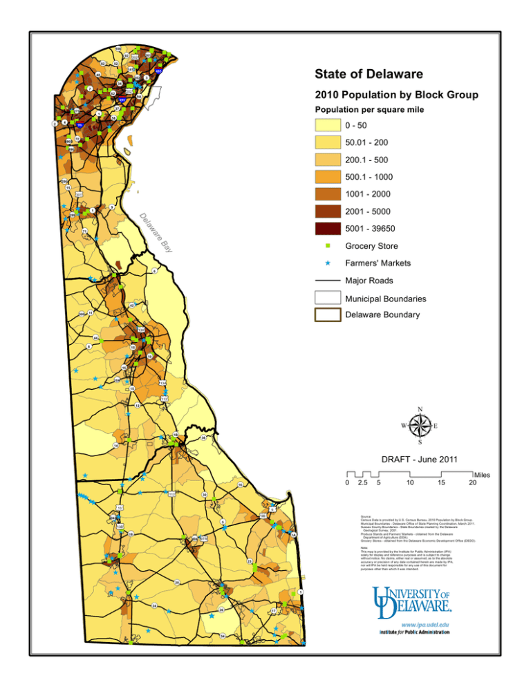
Q R "" "" " " " Q R " Q R£ ¤ Q R Q R Ê" Ê "Ê" R " Q § ¦ ¨ R Ê" Q RQ R" "Q " Ê Ê Q R ""ÊÊÊÊ "Q R " " "Q ¤" Q R £ " " § ¦ R ¨ Ê " Q R""" " Ê"Q R Q R"" Q " " " " R Ê R " "§ Q RQ ¦ " Ê" ¨ " Q R" " Q R "Q R 100 92 82 52 141 48 273 4 2 202 62 State of Delaware 495 202 34 7 261 202 3 2010 Population by Block Group 9A 495 Population per square mile 37 1 58 0 - 50 95 50.01 - 200 72 896B 896 200.1 - 500 Ê Q R Q R 500.1 - 1000 286 15 1001 - 2000 £ ¤ 301 Ê Ê R Ê ""Q "" R ÊQ Ê Q R Ê 2001 - 5000 Q R 9 1 law De 299 5001 - 39650 e ar 71 y Ba Q R 6 " ÊÊ 42 300 Ê Ê Farmers' Markets Municipal Boundaries Q RÊ R Q RQ Grocery Store Major Roads " 11 " Delaware Boundary " " Ê£ ¤ 13A Q R" 44 Q R 8 "" Ê""" Q R" 15 Ê Q R 15 Ê Ê Ê Q R" 10 " Q RÊ Ê Q R 10A £ ¤ 113A 15 Ê Ê £ ¤ 113 Q R 12 Ê Ê " Q R 14 1B µ Q R 36 DRAFT - June 2011 Ê Ê Ê Ê Ê 0 Q R 16 Ê£ ¤ Ê " ÊÊÊÊ ÊÊ Q R " " "" " Q R 113 30 " £ ¤ " £ ¤ " 9B Q RÊ 5 Q R 18 " ÊÊ""Ê Ê Q RÊ£ ¤ 404 9TR ÊÊ "" " Ê 15 Miles 20 Source: Census Data is provided by U.S. Census Bureau, 2010 Population by Block Group. Municipal Boundaries - Delaware Office of State Planning Coordination, March 2011. Sussex County Boundaries - State Boundaries created by the Delaware Geological Survey, 2001. Produce Stands and Farmers' Markets - obtained from the Delaware Department of Agriculture (DDA). Grocery Stores - obtained from the Delaware Economic Development Office (DEDO). ÊQ R 1A Note: This map is provided by the Institute for Public Administration (IPA) solely for display and reference purposes and is subject to change without notice. No claims, either real or assumed, as to the absolute accuracy or precision of any data contained herein are made by IPA, nor will IPA be held responsible for any use of this document for purposes other than which it was intended. Q R"" 23 " Ê Ê 10 9 404B 13B 5 Ê £ ¤ 13 Q RÊÊ £ ¤ Ê" 2.5 Q R 20 " Ê Q R Ê Ê " " Ê 24 Ê " Ê " Q R 26 Q R Ê 54 " Q R 17 " Ê Ê "" Ê Q R 1 Ê Ê

