Proceedings of the Twenty-Seventh Conference on Innovative Applications of Artificial Intelligence
Using Qualitative Spatial Logic for Validating Crowd-Sourced Geospatial Data
Heshan Du
Hai Nguyen
Natasha Alechina
University of Nottingham
Nottingham, UK
hxd@cs.nott.ac.uk
University of Aberdeen
Aberdeen, UK
hai.nguyen@abdn.ac.uk
University of Nottingham
Nottingham, UK
nza@cs.nott.ac.uk
Brian Logan
Michael Jackson
John Goodwin
University of Nottingham
Nottingham, UK
bsl@cs.nott.ac.uk
Nottingham Geospatial Institute
Nottingham, UK
Mike.Jackson@nottingham.ac.uk
Ordnance Survey
Southampton, UK
John.Goodwin@ordnancesurvey.co.uk
Abstract
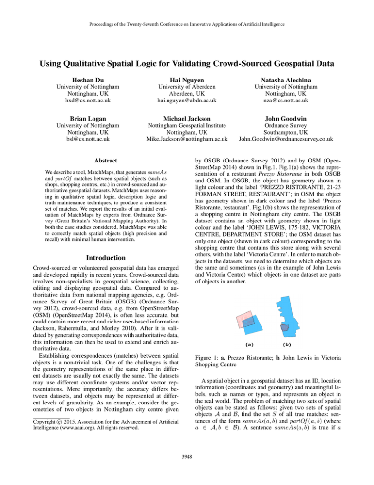
by OSGB (Ordnance Survey 2012) and by OSM (OpenStreetMap 2014) shown in Fig.1. Fig.1(a) shows the representation of a restaurant Prezzo Ristorante in both OSGB
and OSM. In OSGB, the object has geometry shown in
light colour and the label ‘PREZZO RISTORANTE, 21-23
FORMAN STREET, RESTAURANT’; in OSM the object
has geometry shown in dark colour and the label ‘Prezzo
Ristorante, restaurant’. Fig.1(b) shows the representation of
a shopping centre in Nottingham city centre. The OSGB
dataset contains an object with geometry shown in light
colour and the label ‘JOHN LEWIS, 175-182, VICTORIA
CENTRE, DEPARTMENT STORE’; the OSM dataset has
only one object (shown in dark colour) corresponding to the
shopping centre that contains this store along with several
others, with the label ‘Victoria Centre’. In order to match objects in the datasets, we need to determine which objects are
the same and sometimes (as in the example of John Lewis
and Victoria Centre) which objects in one dataset are parts
of objects in another.
We describe a tool, MatchMaps, that generates sameAs
and partOf matches between spatial objects (such as
shops, shopping centres, etc.) in crowd-sourced and authoritative geospatial datasets. MatchMaps uses reasoning in qualitative spatial logic, description logic and
truth maintenance techniques, to produce a consistent
set of matches. We report the results of an initial evaluation of MatchMaps by experts from Ordnance Survey (Great Britain’s National Mapping Authority). In
both the case studies considered, MatchMaps was able
to correctly match spatial objects (high precision and
recall) with minimal human intervention.
Introduction
Crowd-sourced or volunteered geospatial data has emerged
and developed rapidly in recent years. Crowd-sourced data
involves non-specialists in geospatial science, collecting,
editing and displaying geospatial data. Compared to authoritative data from national mapping agencies, e.g. Ordnance Survey of Great Britain (OSGB) (Ordnance Survey 2012), crowd-sourced data, e.g. from OpenStreetMap
(OSM) (OpenStreetMap 2014), is often less accurate, but
could contain more recent and richer user-based information
(Jackson, Rahemtulla, and Morley 2010). After it is validated by generating correspondences with authoritative data,
this information can then be used to extend and enrich authoritative data.
Establishing correspondences (matches) between spatial
objects is a non-trivial task. One of the challenges is that
the geometry representations of the same place in different datasets are usually not exactly the same. The datasets
may use different coordinate systems and/or vector representations. More importantly, the accuracy differs between datasets, and objects may be represented at different levels of granularity. As an example, consider the geometries of two objects in Nottingham city centre given
Figure 1: a. Prezzo Ristorante; b. John Lewis in Victoria
Shopping Centre
A spatial object in a geospatial dataset has an ID, location
information (coordinates and geometry) and meaningful labels, such as names or types, and represents an object in
the real world. The problem of matching two sets of spatial
objects can be stated as follows: given two sets of spatial
objects A and B, find the set S of all true matches: sentences of the form sameAs(a, b) and partOf (a, b) (where
a ∈ A, b ∈ B). A sentence sameAs(a, b) is true if a
c 2015, Association for the Advancement of Artificial
Copyright Intelligence (www.aaai.org). All rights reserved.
3948
and b refer to the same object in the real world. Similarly,
partOf (a, b) is true if the object represented by a is part of
the object represented by b in the real world.
We present a tool, MatchMaps, which generates sameAs
and partOf matches between spatial objects. A preliminary
version of MatchMaps (previously called GeoMap) was described in (Du et al. 2013b); this paper presents a version
with significantly modified match generation algorithms and
the addition of qualitative spatial reasoning. MatchMaps
works by generating candidate matches and checking their
consistency with respect to several sets of sentences: ontology axioms, correspondences between type descriptions
across ontologies, disjointness of types, and qualitative spatial relations between objects. If an inconsistency is found, a
minimal set of statements required to derive it is produced.
One of the statements in this set must be retracted to restore
consistency. The decision about which statement in the minimal inconsistent set is incorrect and should be retracted is
made by a human expert, as no heuristic for making this decision automatically gives sufficiently reliable results.
In this paper, we present an evaluation of MatchMaps on
two case studies. We report the precision (correctness of
matches) and recall (how close the set of generated matches
is to the set of all true matches) of the set of matches between OSGB and OSM representations of Nottingham and
of Southampton city centres relative to ground truth. In
both case studies, MatchMaps was able to correctly match
spatial objects (precision 90% for Nottingham and 98%
for Southampton, recall 84% for Nottingham and 97% for
Southampton) with minimal human intervention.
Figure 2: a. a buffer; b. three hatched circles are buffered
part of (BPT) the solid circle; c. buffered equal (BEQ)
of datasets. For example, in the case of Nottingham city centre, the value of σ for the OSGB and OSM datasets is 20 m.
Interestingly, OSM positional accuracy (maximal error) has
been estimated to be about 20 m in UK (Haklay 2010).
MatchMaps
The main idea underlying MatchMaps is to generate a set
of candidate matches between spatial objects in different
datasets (‘assumptions’) and check for their logical consistency with respect to other available information. The aim
is to produce a maximally consistent subset of candidate
matches which is as close as possible to the set of all true
matches.
The input to MatchMaps is two sets of spatial objects A
and B and two ontologies TA and TB defining concepts for
describing them. (Note that crowd-sourced datasets do not
have formal ontologies, but it is easy to generate simple inclusion hierarchies from their tags.) The output is a set S of
sameAs and partOf matches between objects.
MatchMaps comprises seven main steps summarised below.
Buffered Equal and PartOf
Before we describe MatchMaps and the logical reasoning
involved in it, we need to briefly introduce some relevant
notions. As mentioned above, the geometries of the same
objects in different datasets are not necessarily exactly the
same. This is due to differences in representations, coordinate systems, and errors or imprecision in crowd-sourced
data. Hence we use buffers (ISO Technical Committe 211
2003) to relax equality and the inclusion relation between
geometries.
As shown in Fig. 2(a), by buffering the solid circle x by
σ, we obtain a larger circle, denoted as buffer (x , σ), where
every point is within σ distance from x. A geometry a is a
buffered part of (BPT) of x if all points of a are within the
buffer of x (Fig. 2(b)). Two geometries are buffered equal
(BEQ) with respect to σ, if they fall into the σ-buffer of each
other (Fig. 2(c)). If two geometries are BEQ with respect to
an appropriate level of tolerance σ, then they probably represent the same real world location, otherwise, they represent
different locations.
The level of tolerance σ intuitively corresponds to how
different geometry representations of the same spatial features can be. The value of σ can be established empirically by looking at the two datasets side by side and aligning geometries of several features which are known to be
the same in both datasets. The maximal value required to
make any two geometric representations of the same object
buffered equal (BEQ) gives the value of σ for the given pair
1. Generate disjointness axioms between concepts in TA
and TB . A disjointness axiom is a statement of the form
C1 u C2 = ∅ (the sets of C1 objects and C2 objects are
disjoint; for example, Library u P ub = ∅). The disjointness axioms are generated automatically by assuming the
disjointness of sibling concepts in each ontology. We also
manually generate a small set of axioms that prohibit objects of one type being partOf objects of another type:
School v ∀partOf .¬P ub (if something is a School, then
for all objects it is a part of, they are not Pubs). We use
the description logic reasoner Pellet (Sirin et al. 2007)
to check that adding a set of disjointness and ‘partOf disjointness’ axioms DA to TA does not result in incoherence (existence of provably unsatisfiable concepts), similarly for DB ∪ TB . Axioms that cause incoherence are
removed from DA and DB , resulting in D = DA ∪ DB .
This does not require human interaction. This is an auxiliary step that is needed to facilitate discovering problematic matches (such as a sameAs match between a and b
where a is a Library and b is a Pub).
2. Generate terminology matches between concepts in TA
and TB of the form C1 ≡ C2 where C1 is a concept in TA
and C2 is a concept in TB . Currently we generate terminology matches automatically using a very simple heuristic based on similarity of concept names. For example,
3949
partOf (ai , bj ), partOf (bj , ai ). The output of this step is
the set S of candidate matches. This step does not require
human interaction.
5. Validate matches using LBPT. Check S for consistency
using a qualitative spatial logic, Logic of ParT and whole
for Buffered geometries (LBPT), which is explained in
the next section. If an inconsistency is found, we retract
sameAs or partOf matches from S to restore consistency. This step is implemented using a dedicated LBPT
reasoner and an Assumption-Based Truth Maintenance
System (ATMS). This step may require human interaction
to decide which matches to remove.
Figure 3: a. matching ‘aggregated’ geometries; b. matching
single geometries
OSGB : Shop ≡ OSM : Shop. The set of terminology
matches is M. We check coherence of TA ∪ TB ∪ D ∪ M
using Pellet. For every set of statements responsible for
incoherence, we remove one of the statements in D ∪ M.
This step requires human interaction, because sometimes
we need to decide whether to remove a terminology match
or a disjointness axiom to restore coherence.
6. Validate matches using UNA/NPH. Check S for consistency with respect to UNA or NPH. UNA refers to Unique
Name Assumption: for each dataset, sameAs(a1 , a2 )
does not hold for a1 and a2 with different IDs (each object
is represented exactly once). NPH (No PartOf Hierarchy)
is a stronger assumption that states that there are no objects b1 , b2 in the same set such that partOf (b1 , b2 ) holds.
UNA and NPH hold for the OSGB data. However UNA
or NPH can be violated in the OSM data. Therefore this
check is ‘soft’: if in a crowd-sourced dataset some object
is represented twice, or there is a genuine partOf relationship determined by human checking, we skip this ‘error’
and do not retract any assumptions. This step is required
since even after consistency checks in the previous steps,
there may be ‘too many’ matches in S. It is implemented
using Pellet, and requires human interaction. This is an
optional step, which could be skipped if UNA or NPT is
violated frequently in at least one input dataset.
3. Generate geometry matches using aggregation and
buffering. This is done using standard 2D spatial tools
(Vivid Solutions, Inc. 2014) to aggregate, buffer and
check for inclusions of their geometries. Rather than
matching every single geometry in input datasets, we
generate BEQ correspondences between ‘aggregated’ geometries, each of which is obtained by aggregating a
non-empty collection of adjacent single geometries. The
reason for doing the aggregation step is that sometimes
matching every single geometry is impossible while there
is a clear match between two aggregates. As shown in
Fig.3(a), there is a clear correspondence between aggregated geometries from OSM (dark) and OSGB (light, dotted). However, for a single OSM geometry (dark), there
can be more than one candidate from OSGB (dotted), as
shown in Fig.3(b). We cannot decide which one is correct
based only on the similarity of geometries. This type of
problem often occurs when matching, for example, terraced houses or small shops in a shopping centre. This
step does not require human interaction.
7. Validate matches using classification. Check for consistency of S together with TA ∪ TB ∪ D ∪ M. Restore consistency and return the resulting set S. This step requires
human interaction since either a match in S or a disjointness axiom may be wrong.
In addition to Pellet, the LBPT reasoner and the ATMS,
the implementation of MatchMaps builds on a number of existing tools. The JTS Topology Suite (Vivid Solutions, Inc.
2014) is used to process two dimensional geometries, and
the graphical user interface is implemented using the OpenJUMP libraries (JPP 2014).
4. Generate object matches (sameAs and partOf matches
between objects). For each pair of matched geometries
from the previous step, we consider associated objects and
check them for similarity of labels using a string similarity measure. In straightforward cases, when there are
two objects a and b with similar geometries and similar labels in different datasets, we add sameAs(a, b) to
a set of candidate matches S; or if there is a set of objects {a1 , . . . , an } where the union of their geometries
is similar to a geometry of a single object b in another
dataset, we add partOf (ai , b) to S for every ai . A difficult case is when there is a match between two aggregated geometries which contain objects {a1 , . . . , an } in
one dataset and objects {b1 , . . . , bk } in another dataset
(many-to-many matching case). When we cannot decide
the exact matches automatically using labels and types
of objects, we generate all matches which are possibly
correct between the objects in the two sets: for each pair
ai , bj with similar labels, we generate sameAs(ai , bj ),
Qualitative Spatial Logic
In this section we outline the qualitative spatial logic LBPT
used to detect errors in matches, and briefly give the intuitions behind the logic. The logic itself is presented in (Du
and Alechina 2014).
The language of LBP T contains a set of individual names (for individual geometries), binary predicates
N EAR, F AR and BP T , and logical connectives, ¬
(not), ∧ (and) and → (implies). As introduced before,
BP T and BEQ stand for ‘buffered partOf’ and ‘buffered
equal’ respectively. BEQ(a, b) is defined as BP T (a, b) ∧
BP T (b, a). The relations N EAR and F AR are also defined using a level of tolerance σ. Two geometries a and b
are N EAR if there exist a point pa in a and a point pb in b
such that the distance between pa and pb is at most 2σ. The
3950
intuition is that if a and b are shifted towards each other by σ
they will definitely be touching. Two geometries a and b are
F AR if for any two points pa in a and pb in b, their distance
is strictly greater than 4σ. N EAR and F AR are disjoint but
not mutually exhaustive relations. For two points which are
at the distance of 3σ, they are neither N EAR nor F AR.
A sound and complete axiomatisation of LBPT consists
of the following axioms:
it). Each node has a label that records the minimal sets of
assumptions from which it can be derived.
Whenever a new justification is received from the
problem-solver, the labels of nodes in the graph are updated
to maintain four key properties:
• soundness if a set of assumptions is in the label of a formula, then the reasoner has found a derivation of this formula which only uses those assumptions;
A0 All tautologies of classical propositional logic
• completeness all ways of deriving the formula discovered
by the reasoner so far are included in the label;
A1 BPT (a, a);
A2 NEAR(a, b) → NEAR(b, a);
• minimality the formula (so far) has not been discovered
to be derivable from a strict subset of any set of assumptions in the label;
A3 FAR(a, b) → FAR(b, a);
A4 BPT (a, b) ∧ BPT (b, c) → NEAR(c, a);
• consistency if a set of assumptions is discovered to be inconsistent, then it is removed from the labels of all nodes
(except n⊥ ).
A5 BPT (b, a) ∧ BPT (b, c) → NEAR(c, a);
A6 BPT (b, a) ∧ NEAR(b, c) ∧ BPT (c, d ) → ¬FAR(d , a);
A7 NEAR(a, b) ∧ BPT (b, c) ∧ BPT (c, d ) → ¬FAR(d , a);
The basic task of the ATMS is to compute sound, complete, minimal and consistent labels for datum nodes which
correctly reflect the sequence of justifications generated by
the reasoner. From the label of a node we can therefore determine the minimal sets of assumptions needed to (consistently) derive the corresponding datum discovered by the
reasoner. From the label of the false node n⊥ we can discover the reasons for any inconsistencies in the ontology
(i.e., the ATMS nogoods).
The LBPT reasoner with an ATMS is implemented
in Pop-11 (http://www.cs.bham.ac.uk/research/projects/
poplog/freepoplog.html). The LBPT inference rules are
implemented using Poprulebase, a Pop-11 forward chaining
rule interpreter.
MP Modus ponens: φ, φ → ψ ` ψ.
Initially, LBPT reasoning was implemented using Pellet.
LBPT reasoning rules were encoded as constraints on object
properties. However, not all LBPT reasoning rules are expressible in this way, and we also encountered some bugs
(for example, non-minimal explanations) in the explanations generated using reasoning with role chain inclusions.
We therefore implemented a dedicated LBPT reasoner integrated with an assumption-based truth maintenance system
(ATMS) (de Kleer 1986). The LBPT reasoner derives consequences by applying inference rules to previously derived
sentences, and the ATMS maintains dependencies between
derived consequences and a set of distinguished data known
as assumptions. In particular, it maintains all minimal sets
of assumptions responsible for the derivation of ⊥ (false),
referred to as nogoods in ATMS terminology.
The reasoner reasons using inference rules which encode
the LBPT axioms. It repeatedly checks whether any of its
inference rules are applicable to the assumptions and/or any
previously derived sentences, and if so, it sends to the ATMS
the consequence of applying the rule together with a justification consisting of the name of the rule and the antecedents
of the rule used to derive the consequence. The newly derived consequence can now be used as an input to the reasoner and the cycle repeats until no new consequences can
be derived.
The ATMS computes dependency (or derivability) of data
from sets of assumptions. In our case statements of matches
between objects are treated as assumptions and NEAR and
FAR statements as premises (non-retractable statements). To
compute derivability, the ATMS builds and maintains a dependency or justification graph. A node in the graph represents a unique datum (i.e., a formula). Inconsistency is represented by a distinguished node n⊥ . Justifications form the
edges of the graph and record the fact that a datum node
(the consequent) can be derived from a set of other datum
nodes (the antecedents). A node may be the consequent of
more than one justification (recording the different ways in
which it can be derived), and be an antecedent in other justifications (recording the inferences that can be made using
Experiments and Evaluation
In this section, we report the use of MatchMaps to match
OSM data (building layer) (OpenStreetMap 2014) to OSGB
MasterMap data (Address Layer and Topology Layer) (Ordnance Survey 2012). The studied areas are in city centres
of Nottingham UK and Southampton UK. The Nottingham
data was obtained in 2012, and the Southampton data in
2013. The numbers of spatial objects in the case studies are
shown in Table 1. The number of OSM objects is smaller in
each case, because OSM data often describes a collection of
OSGB objects as a whole, for example, OSGB shops as a
shopping centre in OSM.
Table 1: Data used for evaluation
Nottingham
Southampton
OSM spatial objects
281
2130
OSGB spatial objects
13204
7678
We chose these two datasets for evaluation because they
have a reasonable representation in OSM (city centres usually attract more attention from OSM contributors, and a variety of buildings and places are represented there) and are
of reasonable size. In both cases, we set the value of σ used
in geometry matching to be 20 m. The experiments were
3951
Table 3: LBPT reasoning
Table 2: Matching OSM spatial objects to OSGB
Nottingham
Southampton
TP
177
1997
FP
19
21
TN
64
71
FN
21
41
Precision
0.90
0.98
Recall
0.84
0.97
Nottingham
Southampton
nogoods
172
268
retracted BEQ/BPT
31
114
interactions
3
7
σ = 20m. If a BEQ or BP T assumption is involved in a
derivation of inconsistency and is retracted, then the corresponding sameAs or partOf matches are also retracted.
Table 3 shows the number of nogoods generated by the
LBPT reasoner with an ATMS. The number of interactions
is the number of times users are asked to take actions or
use strategies to resolve problems (a strategy is a heuristic
which allows users to retract all ‘similar’ statements at a
time, for example, all statements of the form partOf (x, o)
for some small object o). As a result of LBPT reasoning and
removal of BEQ and BPT assumptions, we also withdraw
1325 sameAs/partOf assumptions for Nottingham and 488
sameAs/partOf assumptions for Southampton.
Using LBPT reasoning to remove these assumptions
makes a difference to the running time and to the number of
human interactions required to restore consistency in step 6.
If we skip the LBPT reasoning step, and check the matching
with respect to UNA and NPH assumptions directly, then it
would require much more time to calculate explanations for
inconsistencies (see Table 4).
performed on an Intel(R) Core(TM)2 Duo CPU E8400 @
3.00 GHz, 4.00 GB RAM desktop computer. Times are in
seconds, averaged over 5 runs.
The main objective of evaluation was to establish the
precision and recall of MatchMaps. Given the size of the
case studies, it was infeasible for domain experts to produce a complete set of ground truth matches manually. Instead, we computed the ground truth as follows. For each
OSM object a, we check all matches which involve a (either a single sameAs(a, b) match with some b in the OSGB
dataset, or several partOf matches involving a) produced by
MatchMaps. If the match or matches were determined by a
human expert to be correct, a was classified as ‘Correctly
Matched’ (True Positive or T P ), otherwise it was classified as ‘Incorrectly Matched’ (False Positive or F P ). For
a ∈ F P , a check was made whether a correct match for a
existed; if yes, a was labelled F Psbm . If a was not involved
in any matches, a check was made whether a correct match
for it existed. If there was no correct match, then a was
placed in ‘Correctly Not-matched’ (True Negative or T N ),
otherwise in ‘Incorrectly Not-matched’ (False Negative or
F N ). Straightforward matches were checked by a nonexpert using guidelines developed in conjunction with a subject matter expert from the Nottingham Geospatial Institute.
A subject matter expert at Ordnance Survey (Great Britain’s
National Mapping Authority) classified non-straightforward
cases (approximately 10% of the total output of the system
for the given datasets). Note that the size of each group is
the number of OSM spatial objects in it. For example, for
the Victoria Centre in OSM, though there are hundreds of
‘partOf’ matches involving it, it is only counted as one element in ‘Correctly Matched’. Precision was computed as the
ratio of |T P | to |T P | + |F P |, and recall as the ratio of |T P |
to |T P | + |F N | + |F Psbm |. As shown in Table 2, for both
Nottingham and Southampton cases, precision is ≥ 90% and
recall ≥ 84%.
We also performed experiments to evaluate the performance of the qualitative spatial reasoning step (step 5).
In that step, we are primarily interested in consistency of
matches generated in step 4 for the many-to-many case, that
is, sameAs and partOf matches between two sets of objects {a1 , . . . , an } and {b1 , . . . , bk } which belong to two
buffered equal aggregated geometries. To check consistency
of those matches with respect to LBPT, we translate matches
to LBPT. For every sameAs(ai , bj ), we generate an assumption BEQ(g(ai ), g(bj )) and for every partOf (ai , bj ),
we generate an assumption BP T (g(ai ), g(bj )), where g(ai )
and g(bj ) are geometries of ai and bj , respectively. We
also generate N EAR and F AR facts between all objects in
{a1 , . . . , an } and between all objects in {b1 , . . . , bk }, from
distances between geometries within the same dataset, using
Table 4: Time for calculating explanations in UNA and NPH
step by Pellet
Nottingham
Southampton
with LBPT step
16s
3s
without LBPT step
812s
46s
More importantly, more explanations for inconsistency
would be generated by Pellet, since approximately 1800
wrong matches are removed in the LBPT step. The exact
number of additional human interactions is not known since
an attempt to resolve all inconsistencies was abandoned after 4 hours, but it is significantly greater than the number of
interactions required with the LBPT step (see Table 5).
Table 5: UNA and NPH reasoning by Pellet
Nottingham
Southampton
retracted sameAs/partOf
151
199
interactions
11
12
Related Work
Other tools for ontology matching or data interlinking exist, for example LogMap (Jiménez-Ruiz and Grau 2011)
and KnoFuss (Nikolov, Uren, and Motta 2007). In (Du et
al. 2013a), their performance on geospatial datasets is compared to that of the preliminary version of MatchMaps (Du
et al. 2013b). The precision and recall of MatchMaps (on
3952
smaller datasets with manually computed ground truth) are
much higher than that of LogMap and KnoFuss, mainly
because they do not make explicit use of spatial information. Another feature of MatchMaps which explains its
higher precision, is that when an inconsistent set of matching statements and axioms is found, MatchMaps does not
automatically withdraw one of the statements but instead
asks a human expert to make a decision. This approach was
adopted because it was discovered empirically that none of
the commonly-used heuristics for choosing the statement to
withdraw works well in all cases.
In geospatial information science, several methods have
been developed for matching geometries or integrating
geospatial data. Kundu (2006) proposed a method for conflating two polygonal lines, based on a distance measure.
Fu and Wu (2008) proposed a method for matching entities in vector spatial data, based on interior intersection for
polygons and buffer division for lines. Tong et al (2009)
proposed a spatial feature matching method in map conflation, based on the calculation of weighted average of positional, shape, directional, and topological measures. However, there is no consensus approach to matching geometries, and the computational cost of most methods is high.
Crowd-sourced geospatial information introduces additional
challenges, since the geometries are typically less accurate
and may contain errors.
For the application described in this paper, standard spatial formalisms (see, for example, (Aiello, Pratt-Hartmann,
and Benthem 2007)) are not easily applicable since they presuppose accurate geometries or regions with sharp boundaries. Formalisms which consider indeterminate regions,
such as (Roy and Stell 2001), presuppose the existence of
a core part of a region and a more vague part, while in our
application, the real location of the object can be anywhere
within the buffer with the same degree of (un)certainty.
de Kleer, J. 1986. An assumption-based TMS. Artificial
Intelligence 28(2):127–162.
Du, H., and Alechina, N. 2014. A Logic of Part and Whole
for Buffered Geometries. In the 7th European Starting AI
Researcher Symposium (STAIRS), 91–100.
Du, H.; Alechina, N.; Jackson, M.; and Hart, G. 2013a.
Matching Geospatial Instances. In Proceedings of the 8th International Workshop on Ontology Matching, volume 1111 of
CEUR Workshop Proceedings, 239–240. CEUR-WS.org.
Du, H.; Alechina, N.; Jackson, M.; and Hart, G. 2013b.
Matching Formal and Informal Geospatial Ontologies. In Geographic Information Science at the Heart of Europe, Lecture
Notes in Geoinformation and Cartography. Springer. 155–
171.
Fu, Z., and Wu, J. 2008. Entity matching in vector spatial
data. International Archives of the Photogrammetry, Remote
Sensing and Spatial Information Sciences 37(B4):1467 – 72.
Haklay, M. 2010. How good is volunteered geographical information? A comparative study of OpenStreetMap and Ordnance Survey datasets. Environment and Planning B: Planning and Design 37(4):682–703.
ISO Technical Committe 211. 2003. ISO 19107:2003 Geographic information – Spatial schema. Technical report, International Organization for Standardization (TC 211).
Jackson, M. J.; Rahemtulla, H.; and Morley, J. 2010. The
Synergistic Use of Authenticated and Crowd-Sourced Data
for Emergency Response. In 2nd International Workshop on
Validation of Geo-Information Products for Crisis Management (VALgEO), 91–99.
Jiménez-Ruiz, E., and Grau, B. C. 2011. LogMap: LogicBased and Scalable Ontology Matching. In Proceedings
of the10th International Semantic Web Conference, volume
7031 of LNCS, 273–288. Springer.
JPP. 2014. openjump. http://www.openjump.org.
Kundu, S. 2006. Conflating two polygonal lines. Pattern
Recognition 39(3):363–372.
Nikolov, A.; Uren, V.; and Motta, E. 2007. KnoFuss: a Comprehensive Architecture for Knowledge Fusion. In Proceedings of the 4th International Conference on Knowledge Capture, 185–186.
OpenStreetMap.
2014.
The Free Wiki World Map.
http://www.openstreetmap.org.
Ordnance Survey.
2012.
Ordnance Survey.
http://www.ordnancesurvey.co.uk.
Roy, A., and Stell, J. 2001. Spatial Relations between Indeterminate Regions. International Journal of Approximate
Reasoning 27(3):205 – 234.
Sirin, E.; Parsia, B.; Grau, B. C.; Kalyanpur, A.; and Katz, Y.
2007. Pellet: a Practical OWL-DL Reasoner. Web Semantics:
Science, Services and Agents on the World Wide Web 5:51–53.
Tong, X.; Shi, W.; and Deng, S. 2009. A probability-based
multi-measure feature matching method in map conflation.
International Journal of Remote Sensing 30(20):5453–5472.
Vivid Solutions, Inc.
2014.
JTS Topology Suite.
http://www.vividsolutions.com/jts.
Conclusion
Crowd-sourced geospatial datasets contain a wealth of information. However this information is not entirely reliable and
needs to be validated. One way of validating it is to match
the objects described in a crowd-sourced dataset to an authoritative geospatial data source. We describe an application, MatchMaps, that generates such matches and checks
them for consistency with respect to ontological classification of the objects and a qualitative spatial logic. We do
this by extending existing artificial intelligence techniques
for matching ontologies to the more specialised case of a
geospatial ontology (containing location and geometry information), and using a novel qualitative spatial logic to validate the matches. An evaluation of MatchMaps shows a
high degree of precision and recall for two case studies. One
direction of future research is to conduct a user evaluation
study with OSGB to determine the amount of human effort
required to perform a matching task.
References
Aiello, M.; Pratt-Hartmann, I. E.; and Benthem, J. F. v. 2007.
Handbook of Spatial Logics. Springer.
3953

