Inte eraction b a and the no
advertisement
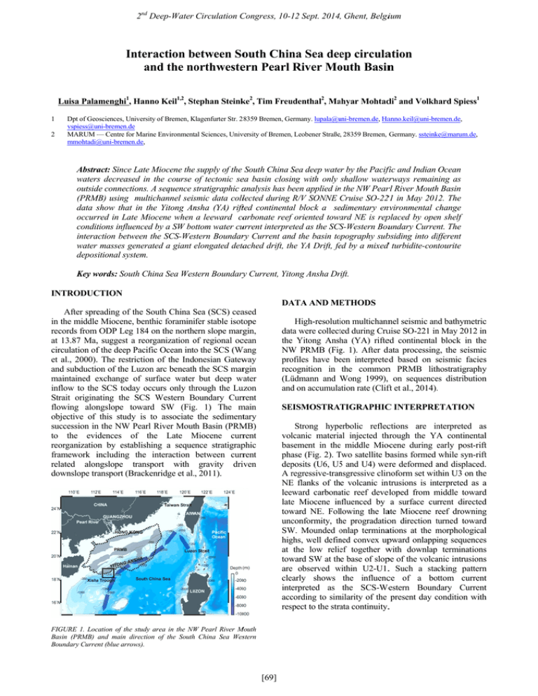
2ndd Deep-Water Circulation C Congress, 10-1 12 Sept. 2014,, Ghent, Belgiium Inteeraction between b Soouth Chin na Sea deeep circulaation a the no and orthwesteern Pearl River Mo outh Basin n Luisa Palaamenghi1, Han nno Keil1,2, Sttephan Steink ke2, Tim Freu udenthal2, Ma ahyar Mohtaddi2 and Volkh hard Spiess1 1 2 Dpt of Geoosciences, Universsity of Bremen, Klagenfurter K Str. 228359 Bremen, Geermany. lupala@u uni-bremen.de, Haanno.keil@uni-brremen.de, vspiess@uuni-bremen.de MARUM — Centre for Marrine Environmenttal Sciences, Univversity of Bremen,, Leobener Straße, 28359 Bremen, Germany. ssteink ke@marum.de, mmohtadi@ @uni-bremen.de, Abstraact: Since Latte Miocene thee supply of the South China Sea S deep wateer by the Paciffic and Indian Ocean waters rs decreased in i the course of tectonic seea basin closing with only shallow water erways remain ning as outsidde connectionss. A sequence stratigraphic s aanalysis has been b applied in n the NW Pearrl River Mouth h Basin (PRM MB) using multichannel seissmic data colllected during R/V SONNE Cruise SO-2221 in May 201 12. The data sshow that in the Yitong An nsha (YA) riftfted continenta al block a seedimentary ennvironmental change c occurr rred in Late Miocene M when a leeward caarbonate reeff oriented towa ard NE is repplaced by open shelf condittions influenceed by a SW bo ottom water cuurrent interpreeted as the SCS S-Western Bouundary Curren nt. The interaaction betweenn the SCS-Wesstern Boundarry Current and the basin to opography subbsiding into dif ifferent waterr masses generrated a giant elongated deta tached drift, th he YA Drift, feed by a mixedd turbidite-con ntourite depossitional system m. Key w words: South China C Sea Wesstern Boundary ry Current, Yito ong Ansha Drrift. INTRODUC CTION DA ATA AND ME ETHODS After spreeading of the South China Sea S (SCS) ceaased in the middlee Miocene, bennthic foraminiifer stable isottope records from ODP Leg 1844 on the northern slope marg rgin, at 13.87 Ma,, suggest a reoorganization of o regional occean circulation off the deep Pacific Ocean into o the SCS (W Wang et al., 2000).. The restrictioon of the Indonesian Gatew way and subductioon of the Luzoon arc beneath h the SCS marrgin maintained eexchange of surface s waterr but deep w water inflow to thee SCS today occurs o only th hrough the Luuzon Strait originaating the SCS Western Boundary B Currrent flowing alonngslope towaard SW (Fig g. 1) The m main objective of this study iss to associate the sedimenttary succession inn the NW Pearrl River Moutth Basin (PRM MB) to the eviidences of the Late Miocene M currrent reorganizatioon by establisshing a sequeence stratigrapphic framework iincluding thee interaction between currrent related alonngslope trannsport with gravity driiven downslope trransport (Brackkenridge et al., 2011). High-resolutiion multichannnel seismic an nd bathymetricc datta were collectted during Cruuise SO-221 in n May 2012 inn thee Yitong Ansh ha (YA) rifteed continental block in thee NW W PRMB (Fig g. 1). After da data processing g, the seismicc pro ofiles have beeen interpreteed based on seismic s faciess reccognition in the commonn PRMB lith hostratigraphyy (Lü üdmann and Wong 1999),, on sequencees distributionn and d on accumulaation rate (Clifft et al., 2014).. EISMOSTRATIGRAPHIC C INTERPRE ETATION SE Strong hypeerbolic reflecctions are in nterpreted ass vollcanic materiaal injected thhrough the YA A continentall bassement in thee middle Mioocene during early post-riftt phaase (Fig. 2). Two T satellite bbasins formed while syn-riftt dep posits (U6, U5 5 and U4) weere deformed and a displaced.. A regressive-tran r nsgressive clinnoform set witthin U3 on thee NE E flanks of th he volcanic int ntrusions is intterpreted as a leeeward carbonaatic reef deveeloped from middle m towardd latee Miocene in nfluenced by a surface current directedd tow ward NE. Following the laate Miocene reef r drowningg uncconformity, th he progradatioon direction turned t towardd SW W. Mounded onlap o terminaations at the morphological m l hig ghs, well defin ned convex uppward onlappiing sequencess at the low relieef together w with downlap terminationss ward SW at th he base of sloppe of the volcaanic intrusionss tow aree observed within w U2-U1.. Such a staacking patternn cleearly shows the influencce of a bo ottom currentt interpreted as the SCS-We Western Bound dary Currentt acccording to sim milarity of the present day condition c withh resspect to the straata continuity.. W Pearl River M Mouth FIGURE 1. Loccation of the studdy area in the NW Basin (PRMB) and main directtion of the South h China Sea Wesstern Boundary Curreent (blue arrows). [69] 2nd Deep-Water Circulation Congress, 10-12 Sept. 2014, Ghent, Belgium FIGURE 2. Interpreted profile GeoB12-094 on the NE flank of the volcanic intrusions showing the margin trajectory of a leeward carbonate reef formed from Middle to Late Miocene (right). The left image shows part of profile GeoB12-096 along Yitong Ansha Drift prograding SW toward the base of slope of the volcanic intrusion from late Miocene to present.. 2) The effect of subaqueous paleo-topographies which no longer exists must be taken into adequate account before drawing general conclusions on global current regimes. EVOLUTIONARY STAGES OF THE YA DRIFT Several sub-units within U1-U2 can be defined, each of them constrained by a distal downlap termination and internally showing a persistent transgressive trend. In the course of the late Miocene (U2.5), a slope fan prograding seaward merged with a wavy sheet unit prograding landward, and formed a giant elongated detached drift, the YA Drift, as a niche-like trap. A debris flow channel with symmetrical levees is incised into unit U2.5. The terrigenous supply from the debris flow channel added to the hemipelagic drift components, resulting in a mixed turbidite-contourite depositional system. The incision became filled at the onset of deposition forming Unit U1.2 of early Pleistocene age when widespread erosion and scouring units occurred (Fig. 2). A dynamic equilibrium sensu Preu et al. (2013) between current and particle settling is restored in late Pleistocene within seafloor undulations that in cross section appear as prograding packages infilling the moat and scours in the uppermost Unit U1.1 ACKNOWLEDGEMENTS This work was carried out in the context of the CARIMA project, BMBF grant 03G0806A. We greatly thank Dr Preu, Prof Hernandez-Molina and Prof Clift for their scientific support. REFERENCES Brackenridge, R., Stow, D.A.V., Hernández-Molina, F.J., 2011. Contourites within a deep-water sequence stratigraphic framework. Geo-Mar. Letters 31, 343360. Clift, P.D., Wan, S., Blusztajn, J., 2014. Reconstructing chemical weathering, physical erosion and monsoon intensity since 25 Ma in the northern South China Sea: A review of competing proxies. Earth-Science Review 130, 86-102. Lüdmann, T., Wong, H.K., 1999. Neotectonic regime on the passive continental margin of the northern South China Sea. Tectonophysics 311, 113-138. Preu, B., Hernandez-Molina, F.J., Violante, R., Piola, A.R., Paterlini, C.M., Schwenk, T., Voigt, I., Krastel, S., Spiess, V., 2013. Morphosedimentary and hydrographic features of the northern Argentine margin: the interplay between erosive depositional and gravitational processes and its conceptual implications. Deep Sea Research I 75, 157-174 Wang P., Prell W.L., Blum P. et al., 2000. Seismic reflection Stratigraphy of Leg 184, South China Sea. Proceedings of the Ocean Drilling Program, Initial Reports 184, 1-37. Xie, X., Müller, R.D., Li, S., Gong, Z., Steinberger, B., 2006. Origin of anomalous subsidence along the Northern South China Sea margin and its relationship to dynamic topography. Marine Petroleum Geology 23, 745-765. DISCUSSION AND CONCLUSIONS The current re-orientation from NE within U3 toward SW within U1-U2 may indicate a change in direction in the late Miocene. An intensification of bottom current activity during the early Pleistocene may be associated to U2.1. However, based on the mean slope subsidence rate (Xie et al., 2006), the igneous intrusions left the surface in late Miocene when the current reorientation is observed. They also move out of the surface circulation (>350 mbsl) during transition from Pliocene to Pleistocene, exactly when erosion, scouring and the moat incision are also observed. When margin subsidence into different water masses modifies the flow regime at the base of slope, it becomes difficult to derive considerations on global scale deep sea oceanic circulation. It can be therefore concluded that: 1) The sedimentary environment succession in the NW PRMB records the chronohistory of the SCS slope margin subsiding from the surface to the lower intermediate water. [70]
