From: AAAI Technical Report WS-96-01. Compilation copyright © 1996, AAAI (www.aaai.org). All rights reserved.
Inference of Local Rainfall Using Qualitative Reasoning
Satoru OISHI and Shuichi IKEBUCHI
Disaster Prevention ResearchInstitute
Kyoto University
Gokasho Uji, Kyoto 611, JAPAN
tetsu @wrcn2.dpri.kyoto-u.ac.jp
Abstract
-A new method, which is based on Qualitative Rea
soning, for severe rainfall forecasting whichoccurs
on a relatively small scale is presented in this paper. First, the overview of existing numerical
weather forecasting methodsare shownwith their
relating scales. Second,qualitative inference of local windis presented. In this scheme,the partial
differential equation is modeledqualitatively and
diagnostically. Finally, a qualitative cumulusmodel
is discussed. This cumulusmodel is designed to
simulate cumulus development process with consideration of cloud microphysicalprocesses and is
expectedto infer the time series variation and distribution of severerainfall.
Introduction
Weatherforecasting is important for preventing disasters
caused by extreme weather such as severe rainfall, severe
drought, severe heat and severe snow. In Japan, severe rainfall is one of the most well-knowncauses of disaster. Here,
a disaster whichoccurs from severe rainfall in northern region of Japanlast year is shownas an exampleto discuss the
characteristics of Japanese flood: A severe rainfall caused
the flood in the northern region of Japan from July 11 to
July 12, 1995. Duringthis flood a life waslost and 68 houses
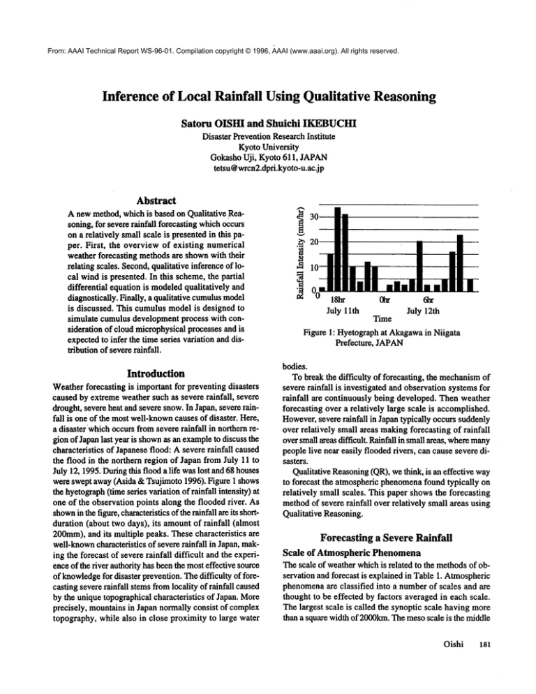
were swept away(Asida &Tsujimoto 1996). Figure 1 shows
the hyetograph(time series variation of rainfall intensity)
one of the observation points along the flooded river. As
shown
in the figure, characteristicsof the rainfall are its shortduration (about two days), its amountof rainfall (almost
200mm),and its multiple peaks. These characteristics are
well-knowncharacteristics of severe rainfall in Japan, making the forecast of severe rainfall difficult and the experience of the river authority has beenthe mosteffective source
of knowledge
for disaster prevention. Thedifficulty of forecasting severe rainfall stemsfromlocality of rainfall caused
by the unique topographical characteristics of Japan. More
precisely, mountains in Japan normally consist of complex
topography, while also in close proximity to large water
18hr
July 11th
~
Time
6IT
July 12th
Figure 1: Hyetographat Akagawain Niigata
Prefecture, JAPAN
bodies.
To break the difficulty of forecasting, the mechanismof
severe rainfall is investigated and observation systems for
rainfall are continuously being developed. Then weather
forecasting over a relatively large scale is accomplished.
However,severe rainfall in Japan typically occurs suddenly
over relatively small areas makingforecasting of rainfall
oversmall areas difficult. Rainfall in small areas, wheremany
people live near easily flooded rivers, can cause severe disasters.
Qualitative Reasoning(QR),we think, is an effective way
to forecast the atmospheric phenomenafound typically on
relatively small scales. This paper showsthe forecasting
methodof severe rainfall over relatively small areas using
Qualitative Reasoning.
Forecasting a Severe Rainfall
Scale of AtmosphericPhenomena
The scale of weather whichis related to the methodsof observation and forecast is explained in Table 1. Atmospheric
phenomenaare classified into a numberof scales and are
thought to be effected by factors averaged in each scale.
The largest scale is called the synoptic scale having more
than a square width of 2000kin. The mesoscale is the middle
Oishi
181
Table 1: Classification of AtmosphericPhenomenaConsidering the Scale
Scale
Synoptic, Meso-a
Scale
(200 km-
Phenomena
Typhoon
Front
Cloud Band
Meso-,B
Scale
Cloud Cluster
(20kin- 200kin)
Rain Band
Severe Rainfall
Tornado
Meso7 Scale
(2 km-20kin)
Thunderstorm
Cumulus, Cumulonimbus
scale and is further classified into three classes; the meso-a
scale having a square width of 2000 - 200km,the meso-/$
scale having a square width of 200 - 20kin and the meso-y
scale having less than a square width of 20 km. Typhoon
and front are classified in the meso-a scale phenomena.
Cloud band and rain band, in which a numberof cumulus
makea line and heavyrainfall continues, are usually classified into the meso-/] scale phenomena.The cumulus, cumulonimbus,thunderstormand tornado are classified in the
meso-ysealephenomena.A severe rainfall whichis usually
caused from cumulus, cumulonimbus
or rain band is classified in the meso-fl to yseale phenomena.
The upper-air observation, whichobservesprofile of temperature, humidityand windspeedand direction at the point
that is located every 250kin, and meteorologicalsatellite
observation is an observation methodof weather in the synoptic scale and the meso-ascale. The data obtained by these
observation are accumulatedinstantaneously and is adjusted
spatially and temporally uniformby using a physical diag182
QR-96
Observation
Forecasting System
Satellite observation
1. Distribution of Cloud
Numerical Model
and Snow
2. Distribution of temperature of see and
Analysis of GPV
land surface
Upper-air observation
1. Profile of temperature, humidity and Weather Forecasting
pressure
2. Wind speed and direction
±
±
Radar
1. Rainfall
area
2. Rainfall intensity
Observation Result of
Rader and AMeDAS
(Autometed meteorological data acquisition
system)
Observation
1. at the groundlevel
including AMeDAS
2. at the surfaceof the
Nowcast(extrapolation)
sea
3. on airplain
±
nostic model. This adjustment is called four dimensional
data assimilation and the adjusted data are used as the initial condition of the weather forecasting model.
NumericalWeatherForecasting
Weatherforecasting is usually based on the result of a numerical atmospheric model. The numerical modelconsists
of the partial differential equationswhichare usually solved
by the spectral method. The Japan Meteorological Agency
had three types of weather forecasting model: the GSM
(Global Spectral Model), which calculates world wide
weather information, the ASM(Asian Spectral Model),
which calculates more detailed weather phenomena
than that
of the GSMthroughout Asia using the result of the GSM,
and the JSM(Japan Spectral Model), whichcalculates more
detailed weather phenomenathan that of ASMin Japanese
regions using the results of the ASM.Recently, these models have changedand the two types of weather forecasting
model, GSMand RSM(Regional Spectral Model) are used.
Table 2: Outline of GPV
Forecasting Time
Scale
Grid Size
GlobalGSMSynoptic
Scale
1.125"
(-110kin)
Synoptic Meso-ct
ASM
Scale
(350kin
-)
75 km
48hr
Meso Scale
JSM (150Kin -)
30 km
24hr
72hr,
192hr,
360hr
However,the modelsof three types are considered in this
paper. At the sametime, the result of a weatherforecasting
modelcalled GPV,which means the Grid Point Value, is
relayed to the river authority. Table 2 showsthe data type
of GPV.The GPVincludes information from synoptic to
the meso-cxscale. As mentionedabove, severe rainfall is
often classified in the meso-fl to 7scale.
Weatherof the meso-fl to 7scale is difficult to forecast
numerically because of limited cOmputationalresources,
stability of calculation, time and cost for computationand
exactness of computation that each phenomenonof this
scale, such as cloud developmentand local front generating, requires. The short term rainfall forecast, whichaims
at forecasting rainfall having a lead time of one to six or
one to twelvehours in the meso-flto 7scale, is usually based
on the linear extrapolation of rainfall area movement
and
its intensity, howeverthe linear extrapolation methodis effective only whenless than three hours of forecasted rainfall is required since non-linear rainfall area movement
is
distinctive in the frameover three hours. Forecast havinga
lead time of more than three hours must consider physical
processes of cumulus.
According to (Sower 1966), important factors which
should be considered in the physically based forecasting
methodof severe rainfall of the meso-7scaleare:
1. initial condition of cumuluswhichis the mainsource
of severe rainfall,
2. effect of topography on cumulusdevelopment,
3. cloud micropbysics.
In the following section, a methodto forecast the amount
and location of severe rainfall with considering these factors are shown.
Forecasting Severe Rainfall Using QR
Inference methods,which is another forecasting methodthan
the existing numericalmethods,can be an effective forecasting methodthrough consideration of the three importantfactors mentionedin the previous section and can break the computational difficulty since weatherforecasters makeforecast
of severe rainfall by inference with taking care of these factors qualitatively. Therefore, forecasting severe rainfall by
using QRis reasonable since QRis the most effective when
inferring physical phenomena.
Anotheradvantage of ORfor forecasting severe rainfall
is the possibility of real time explanationof inference processes to the river authority whenemergencycontrol of dams
and levees are needed. Real time explanation increases the
reliance of a forecasting systemsince the river authority decides control policy only after a forecasting systemoutput is
understood. A numerical forecasting methodneeds an analysis for explanationof the results; howeverit is difficult for
the river authority to analyze these numericalresults during
an emergency.
Therefore, we first showa wayto obtain vertical wind
occurrenceby solving the continuousequation qualitatively.
In essence, this methodcreates a qualitative modelfrom the
existing numerical model. In this method,we propose a diagnosticanswerto the problemof the partial differential equation (the continuous equation) by transforming the coordinate systems. Second, the concept of Qualitative Cumulus
Modelis shownas a methodto obtain the time series variation and distribution of severe rainfall.
Inference of Vertical WindOccurrence
Overviewof the Inference
Thereare three factors whichare importantfor initial condition of cumulus; the stability of atmosphere, the updraft
caused by topography and the water vapor supply, as shown
in figure 2. The stability of atmosphereis determinedfrom
profiles of temperature and humidity. Unstable atmosphere
rise due to its buoyancy, becomingcumulus. Presence of
updraft acts as a trigger of cumulusand also suspendscloud
particles in the air. Watervapor supply, whichprovides the
energy for cumulus, is determinedby amountof water vapor
and horizontal wind strength. Water vapor provides energy
for cumulus,whichis created by these three factors and continues to develop, ultimately causing severe rainfall.
As indicated in figure 2, inferring updraft is one of the
important factors for forecasting severe rainfall in a small
area. Therefore, the inference methodof updraft occurrence
caused by topography averaged in the meso-7scale is designed and implemented.The inference flow is:
1) obtain speedand direction of horizontal windof the
meso-a scale from GPVdata as well as the topographic
informationof the samescale,
Oishi
183
I
NumericalResult larger than I
Mesoa Scale (from GPV)
I
Inference of the Condition of
Atmosphere of Meso 7Scale
using
Q~
~~h.
!
[ Stability
of Atmosphere [ I Updraft Caused by Topography I [ Water Vapor Supply [
Initial CumulusI
Inference
velopment
of Cumulus De-/ TimeSeries Variation and
by Using QR ~=m Distribution of Severe
Rainfall
Figure 2: ImportantFactors for Forecasting Severe Rainfall in the Meso/~to7scale
2) infer the horizontal movement
of windconsidering the
effect of mountainoustopography of the meso-Tscale,
3) infer the effect of slope and the effect of convection,
4) infer the vertical windoccurrenceconsidering both
effect of slope and convection.
Inference Scheme
First, the inference of horizontal movement
of windis explained. Anassumptionis used for representation of horizontal wind movementeffected by the mountainoustopography averaged in the meso-Tscale. The assumptionis that
wind will blow around a mountain, which is represented
by,
[. *]-[.] =-[K][~/o~].
[. *], -[.]
[v *] - [v] = -[K][ah/oay]
, (1)
where,the valiables in brackets meansqualitative variables,
the x axis is set along the direction of windof the meso-~x
scale, given from the numericalinformation, u and v represent the x and y componentof horizontal windspeed of the
meso-o~scale, u* and v* represent the x and y componentof
horizontal windspeed effected by mountainoustopography,
h represents topographyand K represents a coefficient having a positive value. Empirically, this assumptioncan be
considered reasonable.
184
QR-96
Second, inference of vertical wind occurrence is explained. The basic equation of inferring the updraft caused
by topographyis based on the well-knowncontinuous equation of wind,
o
(p.,).o
~(p.,).~(p.w)
(2)
where,u, v andw are windspeedsalongthe x-, y- andzaxis, respectively,andPois the air density.Forrepresenting the topography,a transformationof the z-axis to a saxis is used for the axis of height. The s-coordinate transformation is represented by,
s=
z-h
(3)
H-h"
where,h is the topographical height and H is the height of
the tropopause, whichis the upper boundaryof the troposphere (lowest layer of the atmosphere). Equation (2)
transformed to equation (4) by introducing the s-coordinate,
~(o.~0)=-o.
+H-hL
o. ._~.~
~
(4)
where,(o is the vertical windrepresented
in s-coordinates.
Thefirst termonthe right-handside of equation(4) repre-
¯ sents the effect of convergence,while the secondterm represents the direct effect of slope. Toinfer the occurrenceof
updraft, the effect of convergenceand topographyis inferred
first, then occurrenceof updraft is inferred by addition of
these effects. Usingequation(4), presenceof updraftis qualitatively inferred since o~ at the groundlevel is zero. Consequently, equation (4) is transformedto qualitative equation
(5),
Ou
Ov
Oh
Oh
i.e. updraft occurswhenthe left-hand side of equation(5)
[+1 and downdraftoccurs whenthe left-hand side of equation (5) is [-1.
Exampleof" Inference
Withthe aid of figure 3, an exampleof inferring the occurrence of updraftis presented.First, the notationis explained.
In figure 3, the point whereupdraft is inferred is markedby
a triangle and the curved lines are contours of topography
averaged in the meso-yscale. Windaveraged in the meso-o~
scale is represented by the thick arrow, U, and the wind
averaged in the meso-yseale is represented by the thick
dotted arrow, U*.The x-axis is set in the direction of the
meso-ascale wind, while the x*-axis is set in the direction
of the meso-Tscalewind. The meso-~zscale wind is given
and the horizontal windof meso-Tscaleis inferred by equa-
tion (1) in the x coordinate system. Thenthe occurrence
updraft, w, is inferred using equation(5) in the x*-coordinate
system.
Next, we explain the inference process in figure 3. Since
in this example,Oh/~yis [+] and the y-component
of the mesoscale windis [0], the qualitative value of the y-component
of the meso-yscalewind is inferred to be [-]. Onthe other
hand, since Dh/Dxis [+] and the x-componentof the meso-~
scale wind is [+], the x-componentof the meso-gscalewind
is inferred to be smaller than that of the meso-o~scale wind.
Consequentlythe wind effected by the topography averaged
in the meso-gsealeis represented by the dotted thick arrow,
U*.Now,the x*-axis is set in the samedirection of the mesoyscale wind. The updraft is inferred by using the meso-Tscale
wind, the x*-coordinate system and equation (5). Both Dh/
Dx*and Dh/Dy*are increasing in the x*-coordinatesystem, so
the topographiceffect of updraft is [+]. Thereis no effect of
convergencesince the topographyis strictly increasing along
both the x*-axis and the y*-axis. Consequently, occurrence
of updraft, w= [+], is inferred at the inferencepoint.
The case for non-strictly increasing topographyis explained
using figure 4. This inferenceis the case whenupdraft is blowing along a valley. Themeso-~,scalewindis inferred by followingthe sameprocess as was used in figure 3. Toinfer the
effect of convergence,the meso-yscalewind is inferred at
twopoints other than the inference point; one is along the x*axis and the other is along the y*-axis. Du*/Dx*
is inferred as
[-] by comparingthe windat the inference point and the wind
at the other point along the x*-axis. Dv*/Oy*
is inferred as [-]
[Ov*/c)Y*]=[-],500
\
[ah/ax*]=[+],
j [8h/Oxl=[+.],
700
\
/
Dh/aX]=[+],
[atyax,]=[+],
5O0
Tx
700
X’""
[awaY*l=[+]
y.
[Ou*lOX*
]=[-]
Figure 3: An Exampleof Inference of WindEffected
by Topography
Figure 4: AnExampleof Inference of WindEffected
by Topography(a case along a valley)
Oishi
185
by comparingthe wind at the inference point and the wind
at the other point along the y*-axis. Consequently,the effect of convergenceis inferred as [+]. Thenthe effect of
topography,also inferred similarly to figure 3, is [+]. Using
these two inferences, the occurrenceof updraft is inferred
at the inferencepoint.
Scale of Topography for Inference
Obtaining ~hl~x from numerical topographic data is one
hurdle of this methodin whichthe partial differential equation is solved using qualitative reasoning. Topographyis
obtained by grid data having meshscales from 50mto lkm.
Using Ikm mesh topography data seems appropriate since
the meso-Tscalecumulusis thought to be larger than lkm.
However,variation of high frequency appears in lkm mesh
topographydata since the height of the meshdata is not the
averageover the meshscale. The low pass filter is used for
removingthis variation of high frequency. The equation of
the low pass filter is shownfrom (Doswell1977)in equation (6), (7).
w(x.
-x,.y.-y,),(6)
+ y2 ]
wCx, y)=exp(, x2 4~
)’
(7)
where,(x, y) is the grit point wherethe filtered topographyis obtained, h is unfiltered topographyand ~ is a parameter for the filtering scale. The 100mmeshtopography
is filtered and variations whosewavelength is less than
lkm is almost removed. Then the filtered topography is
adjusted to a lkm meshscale. Consequently,the value for
~h/3x is obtained by comparingthe filtered meshdata of
lkm meshscale.
The inference methodof obtaining Updraft caused by
topography has been shown. The cumulus appearance is
inferred after the other twofactors in figure 2 are inferred
qualitatively. Developmentand movementof the cumulus
mustbe inferred to obtain the severe rainfall distribution.
......................
~
--
r’7
I
Groupel
¢
sndw
.
L........
.. "-,
1~t
~Yes
I..[ ............
No
"--8< o.71"
.e~.~ ,~,,,
betw~n
I hallandlarger
/
[’T .........
"/
,-"" "--,/
Second.roT ~ Initial
~.__...~/)<201~.~
ice particms !
ice cv,stal ~
~’~oilision
h
(
Explanatorynote
D:Diameter
H:Height
p :Density
] Frozen probability
/
i’l Collision between large /
dropletsandsmall particles
:I
Condensed-~¢~’
droplet
Droplet
.~
"]
Initial
Clouddroplet
Cloulnucleus
Figure 5: Microphysical Prcesses of CumulusModel
QR-96
J
I
~cCoOndensati
"~
llection A- .........
lee cr rstal
nucleus
186
h
Qualitative CumulusModel
General Description
Development and movementof the cumulus have been
modeled numerically. The model of cumulus development
is called a microphysical model. The model of cumulus
movementwhich is mainly caused by wind is called the
dynamicmodelor the meteorological primitive model. The
microphysical model consists of the physical processes
shownin figure 5, (Oishi et al. 1994), and the meteorological primitive modelconsists of the equation of continuity,
the momentum
equations, the thermodynamicequation, the
Poissonequation to solve pressure distribution.
Here, the conception of the Qualitative CumulusModel
(QCM)which simulate cumulus development processes
using Qualitative Reasoningis shown. In QCM,existence,
occurrence, developmentand variation of qualitative variables whichrepresent precipitation particles, wind, water
vaporetc. are inferred qualitatively. This inferenceis based
on the qualitative microphysicalprocesses and the qualitative dynamicprocesses. These processes are represented by
the following format; whenconditions A and B are satisfied
then a process C occurs and a result D is created. Inferring
the processes, the QCM
simulates the physical aspect of
cumulusdevelopmentand interaction processes of each cumulusand then the distribution of rainfall is obtainedqualitatively. Consequently, QCM
will provide real-time forecast of the occurrenceand variation of severe rainfall from
cumulus or cumuloninbus.
Structure
of the QCM
The QCM
consists of the initial condition, boundarycondition, the variables and microphysicalprocesses. Theinitial
condition includes the profile of temperature, humidityand
horizontal windspeed. It is obtained from the GPVof the
JSM.Usingthe meso-~scale information as an initial condition of the meso-yscalemodelis the most customaryand
practical wayto start. Theatmosphere,(only the troposphere
is considered),is classified into four elevation types: lower
layer, lower-middle layer, upper-middle layer and upper
layer. This classification is basedon the temperatureshown
in figure 6. Height of cloud base is the boundarybetween
the lower layer and the lower-middlelayer. The height of 0
°C is the boundarybetweenthe lower-middlelayer and upper-middlelayer. Finally, the height of-40 °C, wherewater
does not exist as liquid underany circumstance,is the boundary betweenupper-middlelayer and upper layer. Cloudparticles exist as rain drops(relatively large waterdrops)in the
lower layer, cloud drop (relatively small water drops) and
rain drops in the lower-middle layer, ice drops (sphere
shapedice) in the upper-middlelayer and ice crystals (plate
shapedice) in the upperlayer.
The topographic information is used as boundarycondi-
The Upper Layer
Anvil
The Upper-Middle
Layer
The Lower.Middle
Layer
Cloud Base
The Lower Layer
Ground
Figure 6: Classified Elevation Type in QCM
tion. The topography is obtained as the methodmentioned
above.
The variables consist of dynamicvariables and microphysical variables. The dynamicvariables consist of temperature variation, humidityvariation, horizontal windspeed
variation and vertical wind direction. The microphysical
variables consist of the presence of precipitation particles
whichincludes cloud drop (relatively small water drop), rain
drop (relatively large water drop), ice drop and ice crystals
at each elevation of atmosphere.
The microphysical processes in the QCM
are nucleation,
condensation, freezing, sublimation and melting. Eachprocess is explainedas follows;
Nucleation:nucleation occurs if the stability of atmosphere
is unstable, a trigger exists and enoughwater vapor is
supplied. Whennucleation occurs, cloud drops exist.
Condensation:cloud drops develop into rain drops by
condensation. Condensation occurs when enough water
vapor is supplied and cloud drops exist.
Freezing: cloud drops and rain drops freeze whenthey
are brought into upper-middlelayer.
Sublimation:whenthe upper layer is saturated, sublimation occurs and ice crystals are created.
Melting: melting occurs whenice crystals or ice drops
fall into the lower-middlelayer.
The remaining processes consist of dynamicand thermodynamicprocesses including advection, atmosphereraised
by buoyancy,fairing, dragging,supportingprecipitation particles, divergence, convergence,suspendingof ice crystals
and releasing of latent heat. Eachprocess is explained as
Oishi
187
Ice crystal
Advection
Ice drop
Cumulus]
Melting
Buoyancy
Cloud
Cumulus
I
Divergen/e
~"~
.
Severe Rainfall
Figure 7: CumulusDeveloping Processes Inferred by QCM
follows;
Adveetion:precipitation particles are blownhorizontally
by wind.
Atmosphereraised by buoyancy: when temperature of
an air patch is higher than temperatureof the surrounding air, the air patch is raised by buoyancyand updraft
occurs. This rising process continues until the level of
free convection (LFC).
Falling: precipitationparticles exceptice crystals fall without support from updraft.
Dragging:if the precipitation panicles fall, downdraft
occurs by dragging.
Supporting:precipitation particles are supported by updraft.
Horizontal divergence: whenupdraft and downdraft occur at the sameelevations, horizontal divergenceoccurs.
Horizontal divergence also occurs whendown-draft occurs at the lowerlayer.
Vertical convergence: whenlocal wind collides against
each other, vertical convergenceoccurs updraft.
Suspending:ice panicles are suspendingsince their density is small (0.1g/cm3) and the shape of ice panicles
(often plate like) disturbs their fall.
Releasingof latent heat: latent heat is released and temperature of the air patch increase whennucleation, sublimation and condensation occur.
Forecasting Severe Rainfall Using QCM
Figure 7 illustrates the expected phenomenainferred by
QCMafter implementation. Expected phenomenaare explained as follows: nucleation occurs and cloud drops are
188
QR-96
created in the lower-middlelayer. Temperatureof the air
patch increases and the air patch rises since it is buoyant.
Clouddrop can be supported and then raised; the air patch
rise up to the level of free convection. Cloud drops becomerain drops, ice drops and ice crystals as it rises. Each
precipitation panicle flow horizontally by advectionr As a
result of advection,precipitation particles are not supported
by updraft and tend to fall. The area whereprecipitation
particles fall is wheresevere rainfall and downdraftoccurs. Downdraft
tends to diverge at the groundlevel. Horizontal windthat is a result of this divergencecreates an
updraft where it blowsagainst the topography.
In the QCM,
interaction betweencumulusis represented
by two phenomena;one is a trigger of cumulusand the
other a combination of cumulus. Downdraft caused by
dragging tends to diverge at the groundlevel, then horizontal wind blows. This horizontal wind might cause updraft in mountainous topography and forms another cumulus. Combinationis represented by advection, which
transports precipitation particles to other colliding cumulus.
Finally, the growingpotential of the QCM
for forecasting is discussed. The QCM
must growby obtaining qualitative and/or quantitative information of cumulusand atmosphericphenomena.To obtain such information, investigation of cumulusby using cumulusnumerical models,
data analysis and observations must be continued. The
QCM
will grow by taking the information qualitatively.
Interaction processes betweencumulus,except the two processes mentionedaboveparagraph, are most important processes for further growth of the QCM.Growthof the QCM
by including the qualitative information reflects development of meteorology, (especially cumulusmicrophysics),
for river management.
Conclusions
Numericalmethodsare important to forecast and to investigate the weather for professional atmosphericscientists
and forecasters. However,Qualitative Reasoningis effective to forecasting the severe phenomena
which might cause
disasters. In this paper, we first presented the inference
methodof occurrence of updraft caused by the topography
averagedin the meso-yscale,which is one of the important
factors neededto forecasting severe rainfall in a small area.
In this method,an answerto the problemof the partial differential equations is proposed. Second, the concept of
Qualitative CumulusModel(QCM)is explained. The QCM
forecasts the time series variation of distribution of severe
rainfall by tracing the physical processes. Finally, we must
implement the QCMmust be implemented and run to discuss the possibility of forecasting rainfall in real-time while
addressing the problems of the QCM.
Acknowledgements
This research is foundedby a schalarship of scientific research (representation: Satoru Oishi) from the Ministry
Education.
References
Ashida, K. and Tsujimoto, T. 1996. Characteristics of
Disaster Caused by H-7.7.11-7.12 Severe Rainfall in
Hokuriku Region of Japan. In Proceedings of the
Symposiumon River Disaster 1996. 37-58. Japan Society
of Civil Engineering.
Doswell, C.A. 1977. Obtaining Meteorologically Significant Surface DivergenceFields Throughthe Filtering Property of Objective Analysis. Monthly WeatherReview 15:
885-892
Forbus, Kenneth D. 1981. Qualitative Reasoning about
PhysicalProcesses. P. S. I. J. on A. I. 326-330
Kuipers, Benjamin. 1994. Qualitative Reasoning -Modeling and Simulation with Incomplete Knowledge-. The MIT
Press
Oishi, S., Kitani, Y., Nakakita, E., Ikebuchi, S. and
Takahashi, T. 1994. Numerical Approachto Effect of Updraft on Local Rainfall. Annualsof the Disaster Prevention
ResearchInstitute, KyotoUniversity 37 (B-2): 281-293
Sawyer, J.S. 1952. A Study of the Rainfall of TwoSynoptic Situations. Q. J. R. Met. Soc. 78. 231-241
Oishi
189


