ESIP Education Workshop – Thursday July 16 AGENDA
advertisement
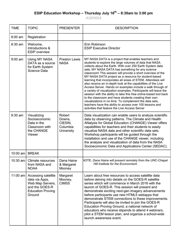
ESIP Education Workshop – Thursday July 16th – 8:30am to 3:00 pm AGENDA TIME TOPIC PRESENTER DESCRIPTION 8:00 am Registration 8:30 am Welcome, Introductions & ESIP overview 9:00 am Using MY NASA DATA as a source for Earth System Science Data Preston Lewis NASA MY NASA DATA is a project that enables teachers and students to explore the large volumes of data that NASA collects about the Earth. With over 250 Earth System data sets, MY NASA DATA has something for any science classroom! This session will provide a short overview of the MY NASA DATA project as a resource for student-based learning that incorporates all areas of STEM. Attendees will also receive an in-depth look at the capabilities of the Live Access Server. Hands on examples include a walk through of a variety of visualization examples. Participants will leave the session with the ability to take this free online-based tool back to the classroom and have students creating their own visualizations in no time. To complement the data sets, teachers have the ability to access over 100 lessons and activities that feature the Live Access Server 9:30 am Visualizing Socioeconomic Data in the Classroom with the CHANGE Viewer Robert Downs, CIESIN, Columbia University Data visualization can enable users to analyze scientific data by observing patterns. The Climate and Health ANalysis for Global Education (CHANGE) Viewer offers capabilities for teachers and their students to easily visualize NASA data and other scientific data sets. Workshop participants will be guided through the installation and use of the CHANGE viewer, including the analysis and visualization of data from the NASA Socioeconomic Data and Applications Center (SEDAC). Erin Robinson ESIP Executive Director 10:00 am BREAK 10:30 am Climate resources from NASA and NOAA Dana Haine & Margaret Mooney 11:00 am Accessing satellite data via Apps, Web Map Servers, and the GOES-R Education Proving Ground Margaret Mooney, CIMSS NOTE: Dana Haine will present remotely from the UNC-Chapel Hill Institute for the Environment. Learn about free resources to access satellite data before delving into details on the GOES-R satellite series which will commence in March 2016 with the launch of GOES-R. This session will present and demonstrate exciting next-gen imagery advancements before participants use new HTML5 webapps that demonstrate STEM connections to these improvements. Participants will also be invited to join the GOES-R Education Proving Ground, a national network of educators who receive stipends to attend 4 webinars, pilot a STEM lesson plan, and organize a school-wide launch awareness event. 11:30 am Using Data to Align Becky Reid with Next Olive Grove Generation Science Charter Standards At the same time that Next Generation Science Standards (NGSS) are calling for science educators to “reflect the interconnected nature of science as it is practiced and experienced in the real world,” vast amounts of scientific data—from satellites, ocean sensors, citizen science weather stations and more— has been made available to the public. How do educators use this data to teach students to construct arguments from evidence, create models of the natural world, and understand the nature of scientific learning? In this session, we will use publicly available data to create an activity where students collect, use and analyze data, then use that data to make evidencebased arguments. 12:00 LUNCH 1:00 pm Using the U.S. Climate Resilience Toolkit to inspire authentic studentled projects LuAnn Dahlman, NOAA CPO Starting with case studies of people who are taking steps to build climate resilience, participants will explore a spectrum of potential pathways for encouraging/inspiring students to initiate resiliencebuilding efforts in their own communities. 1:30 pm Tectonic motions of the western United States. Shelley Olds UNAVCO The land beneath your feet is moving. It's also crumpling, squishing, and stretching. Join us in a workshop to infuse ground motion data from high precision GPS from the EarthScope Plate Boundary Observatory and other networks to explore plate tectonics available from www.unavco.org. The data in the lessons demonstrated in this workshop will allow students to visualize how the world and more specifically California, the Basin and Range, and Cascadia area being deformed at human-scale rates while practicing NGSS concepts, scientific practice, and crosscutting skills. Don't teach plate tectonics like its a moldy historical topic! 2:00 pm Virtual Planet Portal Emily Law NASA JPL NASA’s Lunar Mapping and Modeling Project (LMMP) has developed a set of planet web portals. They allow anyone with access to a computer to explore the Moon, Vesta and Mars virtually. The portal provides easy-touse tools for browsing, data layering and educational information. This session will provide tutorials that can inspire science learning. 2:20 pm Discussion, wrapup & evaluations 3:00 pm adjourn Participants will break into 2 or 3 groups to discuss takeaway strategies and report back to the group.
