Evaluation of sounding capability of the next generation Imager of... using the Advanced Himawari Imager data
advertisement
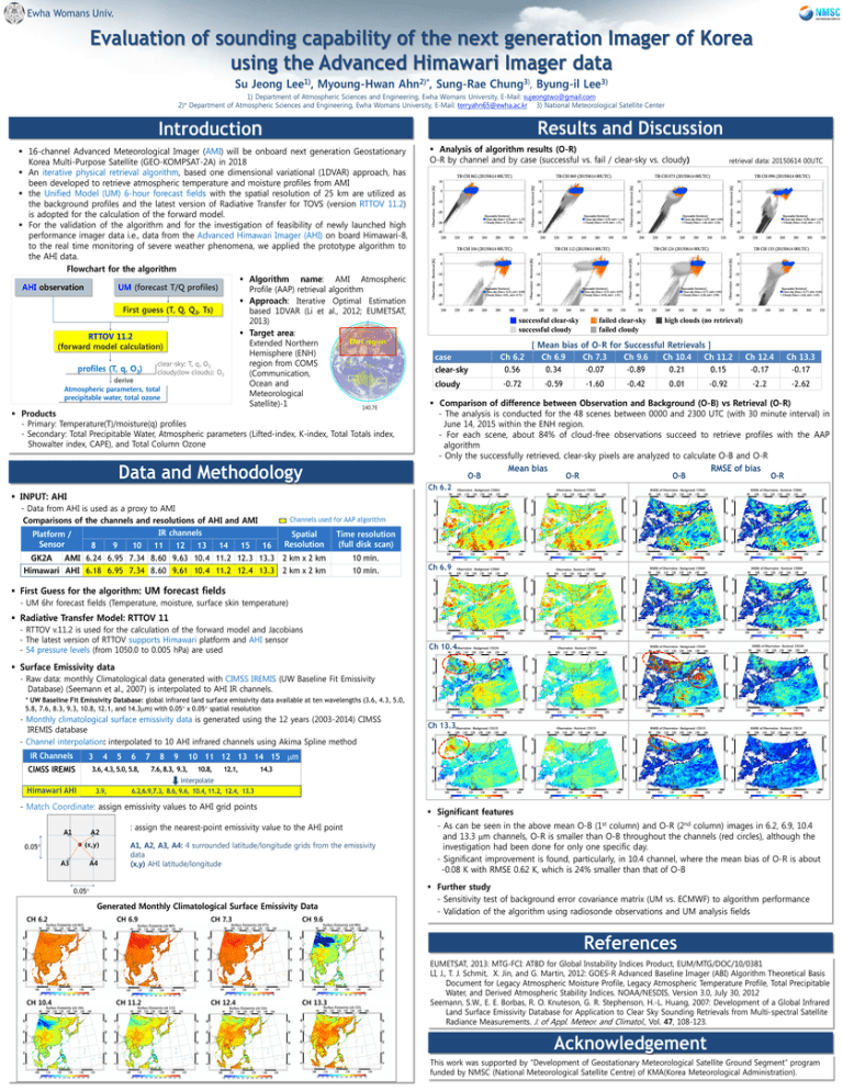
Ewha Womans Univ. Evaluation of sounding capability of the next generation Imager of Korea using the Advanced Himawari Imager data Su Jeong Lee1), Myoung-Hwan Ahn2)*, Sung-Rae Chung3), Byung-il Lee3) 1) Department of Atmospheric Sciences and Engineering, Ewha Womans University, E-Mail: sujeongtwo@gmail.com 2)* Department of Atmospheric Sciences and Engineering, Ewha Womans University, E-Mail: terryahn65@ewha.ac.kr 3) National Meteorological Satellite Center Introduction Results and Discussion 16-channel Advanced Meteorological Imager (AMI) will be onboard next generation Geostationary Korea Multi-Purpose Satellite (GEO-KOMPSAT-2A) in 2018 An iterative physical retrieval algorithm, based one dimensional variational (1DVAR) approach, has been developed to retrieve atmospheric temperature and moisture profiles from AMI the Unified Model (UM) 6-hour forecast fields with the spatial resolution of 25 km are utilized as the background profiles and the latest version of Radiative Transfer for TOVS (version RTTOV 11.2) is adopted for the calculation of the forward model. For the validation of the algorithm and for the investigation of feasibility of newly launched high performance imager data i.e., data from the Advanced Himawari Imager (AHI) on board Himawari-8, to the real time monitoring of severe weather phenomena, we applied the prototype algorithm to the AHI data. Flowchart for the algorithm Algorithm name: AMI Atmospheric AHI observation UM (forecast T/Q profiles) Profile (AAP) retrieval algorithm Approach: Iterative Optimal Estimation First guess (T, Q, Q3, Ts) based 1DVAR (Li et al., 2012; EUMETSAT, 2013) Target area: RTTOV 11.2 ENH region Extended Northern (forward model calculation) Hemisphere (ENH) region from COMS clear-sky: T, q, O3 profiles (T, q, O3) cloudy(low clouds): O3 (Communication, derive Ocean and Atmospheric parameters, total Meteorological precipitable water, total ozone Satellite)-1 140.7E Products - Primary: Temperature(T)/moisture(q) profiles - Secondary: Total Precipitable Water, Atmospheric parameters (Lifted-index, K-index, Total Totals index, Showalter index, CAPE), and Total Column Ozone Data and Methodology ■ successful clear-sky ■ successful cloudy case clear-sky cloudy ■ failed clear-sky ■ failed cloudy retrieval data: 20150614 00UTC ■ high clouds (no retrieval) [ Mean bias of O-R for Successful Retrievals ] Ch 6.2 Ch 6.9 Ch 7.3 Ch 9.6 Ch 10.4 Ch 11.2 0.56 0.34 -0.07 -0.89 0.21 0.15 -0.72 -0.59 -1.60 -0.42 0.01 -0.92 Ch 12.4 -0.17 Ch 13.3 -0.17 -2.2 -2.62 Comparison of difference between Observation and Background (O-B) vs Retrieval (O-R) - The analysis is conducted for the 48 scenes between 0000 and 2300 UTC (with 30 minute interval) in June 14, 2015 within the ENH region. - For each scene, about 84% of cloud-free observations succeed to retrieve profiles with the AAP algorithm - Only the successfully retrieved, clear-sky pixels are analyzed to calculate O-B and O-R Mean bias RMSE of bias O-B O-R O-B O-R Ch 6.2 INPUT: AHI - Data from AHI is used as a proxy to AMI Comparisons of the channels and resolutions of AHI and AMI IR channels Platform / Sensor 8 9 10 11 12 13 14 15 16 GK2A AMI 6.24 6.95 7.34 8.60 9.63 10.4 11.2 12.3 13.3 Himawari AHI 6.18 6.95 7.34 8.60 9.61 10.4 11.2 12.4 13.3 Analysis of algorithm results (O-R) O-R by channel and by case (successful vs. fail / clear-sky vs. cloudy) Channels used for AAP algorithm Spatial Resolution Time resolution (full disk scan) 2 km x 2 km 2 km x 2 km 10 min. 10 min. Ch 6.9 First Guess for the algorithm: UM forecast fields - UM 6hr forecast fields (Temperature, moisture, surface skin temperature) Radiative Transfer Model: RTTOV 11 - RTTOV v.11.2 is used for the calculation of the forward model and Jacobians - The latest version of RTTOV supports Himawari platform and AHI sensor - 54 pressure levels (from 1050.0 to 0.005 hPa) are used Ch 10.4 Surface Emissivity data - Raw data: monthly Climatological data generated with CIMSS IREMIS (UW Baseline Fit Emissivity Database) (Seemann et al., 2007) is interpolated to AHI IR channels. * UW Baseline Fit Emissivity Database: global infrared land surface emissivity data available at ten wavelengths (3.6, 4.3, 5.0, 5.8, 7.6, 8.3, 9.3, 10.8, 12.1, and 14.3m) with 0.05 x 0.05 spatial resolution - Monthly climatological surface emissivity data is generated using the 12 years (2003-2014) CIMSS IREMIS database - Channel interpolation: interpolated to 10 AHI infrared channels using Akima Spline method IR Channels 3 CIMSS IREMIS 4 5 6 3.6, 4.3, 5.0, 5.8, 7 8 Ch 13.3 10 11 12 13 14 15 m 9 7.6, 8.3, 9.3, 10.8, 12.1, 14.3 interpolate Himawari AHI 3.9, 6.2,6.9,7.3, 8.6, 9.6, 10.4, 11.2, 12.4, 13.3 - Match Coordinate: assign emissivity values to AHI grid points A1 A2 (x,y) 0.05 A3 A4 Significant features : assign the nearest-point emissivity value to the AHI point A1, A2, A3, A4: 4 surrounded latitude/longitude grids from the emissivity data (x,y) AHI latitude/longitude 0.05 Generated Monthly Climatological Surface Emissivity Data CH 6.2 CH 6.9 CH 7.3 CH 9.6 - As can be seen in the above mean O-B (1st column) and O-R (2nd column) images in 6.2, 6.9, 10.4 and 13.3 m channels, O-R is smaller than O-B throughout the channels (red circles), although the investigation had been done for only one specific day. - Significant improvement is found, particularly, in 10.4 channel, where the mean bias of O-R is about -0.08 K with RMSE 0.62 K, which is 24% smaller than that of O-B Further study - Sensitivity test of background error covariance matrix (UM vs. ECMWF) to algorithm performance - Validation of the algorithm using radiosonde observations and UM analysis fields References CH 10.4 CH 11.2 CH 12.4 CH 13.3 EUMETSAT, 2013: MTG-FCI: ATBD for Global Instability Indices Product, EUM/MTG/DOC/10/0381 LI, J., T. J. Schmit, X. Jin, and G. Martin, 2012: GOES-R Advanced Baseline Imager (ABI) Algorithm Theoretical Basis Document for Legacy Atmospheric Moisture Profile, Legacy Atmospheric Temperature Profile, Total Precipitable Water, and Derived Atmospheric Stability Indices. NOAA/NESDIS, Version 3.0, July 30, 2012 Seemann, S.W., E. E. Borbas, R. O. Knuteson, G. R. Stephenson, H.-L. Huang, 2007: Development of a Global Infrared Land Surface Emissivity Database for Application to Clear Sky Sounding Retrievals from Multi-spectral Satellite Radiance Measurements. J. of Appl. Meteor. and Climatol., Vol. 47, 108-123. Acknowledgement This work was supported by “Development of Geostationary Meteorological Satellite Ground Segment” program funded by NMSC (National Meteorological Satellite Centre) of KMA(Korea Meteorological Administration).
