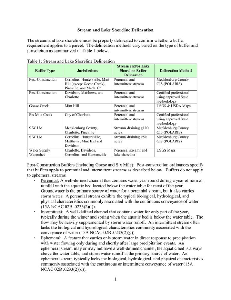
The stream and lake shoreline must be properly delineated to... requirement applies to a parcel. The delineation methods vary... Stream and Lake Shoreline Delineation
advertisement

Stream and Lake Shoreline Delineation The stream and lake shoreline must be properly delineated to confirm whether a buffer requirement applies to a parcel. The delineation methods vary based on the type of buffer and jurisdiction as summarized in Table 1 below. Table 1: Stream and Lake Shoreline Delineation Buffer Type Post-Construction Post-Construction Jurisdictions Cornelius, Huntersville, Mint Hill (except Goose Creek), Pineville, and Meck. Co. Davidson, Matthews, and Charlotte Goose Creek Mint Hill Six Mile Creek City of Charlotte S.W.I.M Mecklenburg County, Charlotte, Pineville Cornelius, Huntersville, Matthews, Mint Hill and Davidson Charlotte, Davidson, Cornelius, and Huntersville S.W.I.M Water Supply Watershed Stream and/or Lake Shoreline Buffer Delineation Perennial and intermittent streams Perennial and intermittent streams Perennial and intermittent streams Perennial and intermittent streams Streams draining >100 acres Streams draining >50 acres Perennial streams and lake shoreline Delineation Method Mecklenburg County GIS (POLARIS) Certified professional using approved State methodology USGS & USDA Maps Certified professional using approved State methodology Mecklenburg County GIS (POLARIS) Mecklenburg County GIS (POLARIS) USGS Maps Post-Construction Buffers (including Goose and Six Mile): Post-construction ordinances specify that buffers apply to perennial and intermittent streams as described below. Buffers do not apply to ephemeral streams. • Perennial: A well-defined channel that contains water year round during a year of normal rainfall with the aquatic bed located below the water table for most of the year. Groundwater is the primary source of water for a perennial stream, but it also carries storm water. A perennial stream exhibits the typical biological, hydrological, and physical characteristics commonly associated with the continuous conveyance of water (15A NCAC 02B .0233(2)(i)). • Intermittent: A well-defined channel that contains water for only part of the year, typically during the winter and spring when the aquatic bed is below the water table. The flow may be heavily supplemented by storm water runoff. An intermittent stream often lacks the biological and hydrological characteristics commonly associated with the conveyance of water (15A NCAC 02B .0233(2)(g)). • Ephemeral: A feature that carries only storm water in direct response to precipitation with water flowing only during and shortly after large precipitation events. An ephemeral stream may or may not have a well-defined channel, the aquatic bed is always above the water table, and storm water runoff is the primary source of water. An ephemeral stream typically lacks the biological, hydrological, and physical characteristics commonly associated with the continuous or intermittent conveyance of water (15A NCAC 02B .0233(2)(d)). 1 The post-construction ordinances for Cornelius, Huntersville, Mint Hill (except Goose Creek), Pineville, and Mecklenburg County specify that Mecklenburg County GIS will delineate the perennial and intermittent streams that require buffers using the most current digital elevation model of no greater than 10-foot cells. The ordinances further specify that this GIS coverage will be periodically updated as new data becomes available. As previously described, POLARIS is the tool used by Mecklenburg County GIS to communicate this information to the public through the layer entitled “Water Quality Buffers.” POLARIS also indicates the postconstruction buffers for Davidson, Matthews, and Charlotte as well as Goose Creek in Mint Hill; however, the ordinances for these jurisdictions specifically state that the perennial and intermittent streams that require buffers must be delineated by a certified professional using U.S. Army Corps of Engineers and N.C. Division of Water Quality methodology. CharlotteMecklenburg Storm Water Services has determined that these delineations will be performed using the most recent version of the N.C. Stream Identification Methodology developed by the N.C. Division of Water Quality. For new developments, a certified professional must document these delineations in Davidson, Matthews, Charlotte and Goose Creek and cannot rely on POLARIS for final delineation as in the other jurisdictions. Staff with Charlotte-Mecklenburg Storm Water Services and the N.C. Division of Water Quality are considered certified professionals if they have satisfactorily completed the latest version of the “Surface Water Identification Training and Certification” or SWITC. However, SWITC is not available to the private sector. Therefore, at the discretion of Charlotte-Mecklenburg Storm Water Services, the private sector may be considered certified if they have satisfactorily completed the “Intermittent and Perennial Stream Identification” class offered by N.C. State University (contact Kelly McCarter at 919-515-9563). Staff may also consider other training and experience toward meeting private sector certification requirements as deemed appropriate. The Program Manager shall make the final determination regarding all certifications and a list of certified professional will be maintained along with their qualifications. An exception to this rule has been made for the buffers in Goose Creek. The N.C. Division of Water Quality has field delineated all the intermittent and perennial streams in the Mecklenburg County portion of Goose Creek using the N.C. Stream Identification Methodology. In December 2012, this data was made available to Charlotte-Mecklenburg Storm Water Services and is accessible through Cityworks as a GIS layer. It is important to note that a delineation made by the N.C. Division of Water Quality will always have precedent over a delineation made by Charlotte-Mecklenburg Storm Water Services. Therefore, whenever s stream delineation is required for a Goose Creek buffer the data provided by the N.C. Division of Water Quality located in Cityworks will be used and CharlotteMecklenburg Storm Water Services will not perform a separate delineation. If staff has questions or concerns regarding this data, they are to consult with the Program Manager. S.W.I.M. Buffers: S.W.I.M. buffer ordinances specify that buffers apply at the point that a stream drains greater than or equal to 50 or 100 acres depending on the jurisdiction regardless of whether the stream is perennial or intermittent. The ordinances further specify that Mecklenburg County GIS will delineate these streams. This data is included in POLARIS under the layer entitled “Water Quality Buffers.” Water Supply Watershed Buffers: Water supply watershed ordinances specify that buffers apply to the perennial streams as defined above that drain to the Catawba River lakes identified by a 2 solid blue line on the USGS quadrangle maps. Mecklenburg County has digitally incorporated these maps into its POLARIS coverage as part of the layer entitled “Water Quality Buffers.” The ordinances also specify that buffers apply to the lake shoreline, which must be delineation by a registered land surveyor based on the full pond elevation of the lake set by Duke Power as follows: 1. Lake Norman = 760 feet 2. Mountain Island lake = 647.5 feet 3. Lake Wylie = 569.4 feet For buffers that apply to intermittent and/or perennial streams, which includes the postconstruction and water supply watershed buffers, a property owner or designee can request a stream evaluation for possible exclusion from the buffer requirements using the process described below. For commercial developments and subdivisions, the same process applies except the owner or designee is required to submit a Stream Reach Evaluation Form prepared by a certified professional for review by the Mecklenburg County Water Quality Program along with the “Application for Stream Exemption” described in step 1 below. 1. The owner or designee must submit an “Application for Stream Exemption” in the form of a letter to the Mecklenburg County Water Quality Program with CharlotteMecklenburg Storm Water Services at 700 North Tryon Street Charlotte, N.C. 28202. A map must also be enclosed with the letter showing the location of the stream reach being requested for evaluation. 2. Upon receipt of this letter with enclosures, the Mecklenburg County Water Quality Program will assign staff to evaluate the stream reach and complete the Stream Reach Evaluation Form. 3. Upon completion of the evaluation, staff will compare their completed Stream Reach Evaluation Form to the requirements of the applicable ordinance and determine if a buffer applies. Staff will describe their findings in an Activity Report and attach the completed Stream Reach Evaluation Form as well as the appropriate notification letter to the applicant contained in Appendices 9 and 10. Staff will also attach an aerial photo of the stream reach from POLARIS. Staff will forward this Activity Report to their Supervisor for review and approval. 4. Upon approval or disapproval, the Supervisor will forward the signed letter and attached documents to the Water Quality Administrative Assistant for mailing. 5. If the stream buffer is not properly delineated in POLARIS, the Supervisor will inform the Watershed Manager and the POLARIS coverage will be updated as necessary to be consistent with staff findings. 6. Appeal of a decision regarding stream reach exclusion from buffer requirements is through the Storm Water Advisory Committee. For S.W.I.M. Buffers that are required based on the size of the upstream drainage area, a property owner or designee can request a stream evaluation for possible exclusion from the buffer requirements using the following process. 1. The owner or designee must submit an “Application for Stream Buffer Change in POLARIS” in the form of a letter to the Mecklenburg County Water Quality Program with Charlotte-Mecklenburg Storm Water Services at 700 North Tryon Street Charlotte, N.C. 28202. A topographic map must be enclosed with this letter identifying the stream 3 2. 3. 4. 5. 6. reach in question and corresponding upstream drainage area. Calculations must be provided with this map showing the methodology for delineating the size of this drainage area. Upon receipt of this letter with enclosures, the Mecklenburg County Water Quality Program will assign staff to evaluate the information provided and confirm the size of the upstream drainage area for the stream section in question. Upon completion of the evaluation, staff will compare their findings to the requirements of the applicable ordinance and determine if a buffer applies. Staff will describe their findings in an Activity Report and forward to their Supervisor for review and approval. Upon approval or disapproval, the Supervisor will inform staff to notify the property owner or designee of the determination. This notification can be in the form of an email or letter. The Supervisor will inform the Watershed Manager of any required changes in POLARIS. Appeal of a decision regarding stream reach exclusion from buffer requirements is through the Storm Water Advisory Committee. In POLARIS, stream delineations are digitally derived from topography generated from aerial surveys and most of the stream sections have not been field verified; therefore, errors sometimes occur in these delineations. The USGS maps used to delineate the water supply watershed buffers can also contain errors. In some situations, a stream may be shown on a parcel with a corresponding buffer where in actuality no stream exists. This can occur when a stream is piped underground or when an error occurs in POLARIS or the USGS mapping process. In such situations, the property owner or designee can contact the Mecklenburg County Water Quality Program with Charlotte-Mecklenburg Storm Water Services for assistance. If field verification is required, the process described above will be followed. In some situations the Program Manager or Supervisor may elect to perform the evaluation without receiving a written request from the owner or designee (#1 above). In some situations, it may be determined through a field evaluation that a stream exists on a parcel that is subject to buffer requirements but is not shown in POLARIS or on USGS maps. In such situations, the buffer requirement will apply and POLARIS will be updated to include the buffered section of stream. In addition to the processes outlined above, a property owner or designee may contact the Mecklenburg County Water Quality Program with Charlotte-Mecklenburg Storm Water Services at 704-336-5456 to request assistance with a stream delineation for a buffer requirement. In some circumstances, Charlotte-Mecklenburg Storm Water Services may elect to delineate a stream or confirm the size of an upstream drainage basin in POLARIS without receiving a request from a property owner or other concerned party. For all buffer types and in all jurisdictions in Mecklenburg County, water quality buffers do not apply to the following: • Ditches and manmade conveyances other than modified natural streams. • Manmade ponds and lakes that are not intersected by a buffered stream segment and that are located outside natural drainage ways. • Ephemeral conveyances, which contain water only when it rains. • Piped stream sections. 4


