Enclosure 3A - Project Summary Form
advertisement
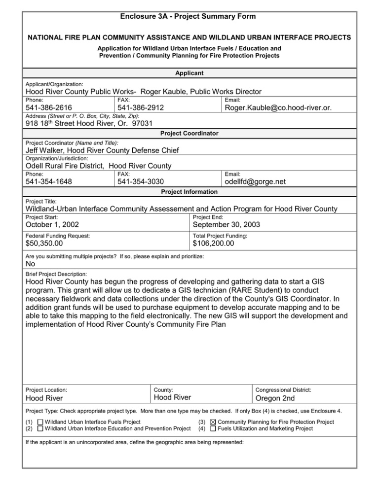
Enclosure 3A - Project Summary Form NATIONAL FIRE PLAN COMMUNITY ASSISTANCE AND WILDLAND URBAN INTERFACE PROJECTS Application for Wildland Urban Interface Fuels / Education and Prevention / Community Planning for Fire Protection Projects Applicant Applicant/Organization: Hood River County Public Works- Roger Kauble, Public Works Director Phone: FAX: Email: 541-386-2616 541-386-2912 Roger.Kauble@co.hood-river.or. Address (Street or P. O. Box, City, State, Zip): 918 18th Street Hood River, Or. 97031 Project Coordinator Project Coordinator (Name and Title): Jeff Walker, Hood River County Defense Chief Organization/Jurisdiction: Odell Rural Fire District, Hood River County Phone: FAX: Email: 541-354-1648 541-354-3030 odellfd@gorge.net Project Information Project Title: Wildland-Urban Interface Community Assessement and Action Program for Hood River County Project Start: Project End: October 1, 2002 September 30, 2003 Federal Funding Request: Total Project Funding: $50,350.00 $106,200.00 Are you submitting multiple projects? If so, please explain and prioritize: No Brief Project Description: Hood River County has begun the progress of developing and gathering data to start a GIS program. This grant will allow us to dedicate a GIS technician (RARE Student) to conduct necessary fieldwork and data collections under the direction of the County's GIS Coordinator. In addition grant funds will be used to purchase equipment to develop accurate mapping and to be able to take this mapping to the field electronically. The new GIS will support the development and implementation of Hood River County’s Community Fire Plan Project Location: County: Congressional District: Hood River Hood River ru Oregon 2nd Project Type: Check appropriate project type. More than one type may be checked. If only Box (4) is checked, use Enclosure 4. (1) (2) Wildland Urban Interface Fuels Project Wildland Urban Interface Education and Prevention Project (3) (4) Community Planning for Fire Protection Project Fuels Utilization and Marketing Project If the applicant is an unincorporated area, define the geographic area being represented: Enclosure 3B (Page 1 of 3) - Project Narrative Description Applications for funding must include a narrative response that describes the proposal. Please do not submit responses longer than one page, single space, 12-pitch font. Describe project including, but not limited to: project location Address these project implementation items as anticipated outcomes applicable: measures and reporting partners project income project time frames specify types of activities and equipment used amount or extent of actions (acres, number of homes, etc) environmental, cultural and historical resource requirements >Project Location: Hood River County. Hood River County’s Public Works GIS division will conduct project implementation. This project may be combined with other National Fire Plan projects to help maximize the results. Response: >The anticipated outcomes: This data will improve emergency response times by local agencies. It will identify hazards to improve fire fighter safety. Location of ingress and egress routes will be plotted. To complete existing road maps in the interface areas to include all roads containing residences. This will include identifying the correct address range for all road segments so emergency response personal can easily locate houses. Complete the topology for all roads to ensure connectivity at all intersections in order to use these maps with routing software, which will be purchased as part of this grant. Identify the location and ownership of all structures in the project areas using Digital Ortho photomaps. Identify water sources in rural areas, including working with local irrigation companies to identify canal and access points. This information will help Hood River County fire agencies to complete its community fire plan and allow it to meet its needs under the National Fire Plan. >The Hood River County GIS division and partners including Fire Districts, Oregon Department of Forestry, Federal Forestry, National Scenic Area, Hood River County Emergency 911 and others will conduct Measuring and Reporting >Project Time Frame: The GIS portion of the project should be completed within 12 months beginning October 1, 2002. This plan proposes the use of a RARE Student for the bulk of the work and the RARE Program time is 12 months (October 1 through September 30) >Specify types of activities and equipment used: >Activities included collecting and disseminating of data and maps. Information will be collected and enter in a computer data base Equipment used computers, GPS units and mapping software. The goal is to provide an IPAC hand held computer for each fire district, loaded with a graphic data base composed of a background photomap, road system, driveways and addresses. These units to be equiped with a GPS card and antenna that will locate the position of the vehicle and display its relative location on the graphic data base. >Amount or extent of actions (acres, number of homes, etc.) An estimated 115,000 acres and homes 6,500 in or near the urban interface area. There are a number of homes outside Rural Fire Protection Districts that have no structural fire protection. They are located on or near forestry lands. . . Enclosure 3B (Page 2 of 3) - Project Evaluation Criteria Applications for funding must include narrative responses that address the following four criteria. Within each criterion, subcriteria are listed in descending order of importance. Limit your responses to the areas provided. 1. Reducing Fire Risk. (40 points)) A. Describe how the proposal promotes reduction of risk in high hazard areas or communities. B. Describe how the proposed project benefits resources on federal land or adjacent non-federal land, or how it protects the safety of communities. C. To what extent does the project implement or create a cooperative fuels treatment plan or community fire strategy (include evidence of the plan if it already exists)? D. Explain to what extent the affected community or proponent has been involved or plans to involve the affected community in a qualified fuels education program (e.g., FIREWISE). E. Explain how the proposal (a) leads to, enhances or restores a local fire-adapted ecosystem, and/or (b) mitigates or leads to the mitigation of hazardous fuel conditions. F. How will the proposed treatments be maintained over time? Response: (A) The GIS mapping will assist all fire agencies in fire management planning, response and protection. The reduction in the overall size and damage from fires, which will result from this project, will result in improved fire protection for individual structures, communities as a whole, watersheds, wildlife and all other values at risk from uncontrolled fire. This information will benefit in locating fuel risk problems areas and develop a plan for future funding. (B) These communities are bordering federal lands that are subject to fire risk. (C) The project will identify areas with fire risk and related to structures, that will be used with a future planning. Mapping of structures, water sources, egress, ingress will aid risk management assessment. 2. Increasing local capacity. (30 points) A. How would the proposal improve or lead to the improvement of the local economy in terms of jobs and sustainable economic activity? How many jobs are expected to be created or retained and for how long (please distinguish between essentially yearround and seasonal jobs)? B. To what extent will this project be offered to serve as a model for other communities? C. Will biomass or forest fuels be utilized; if so, in what manner and how much? Response: The GIS project will aid in the capabilities of Hood River county fire agencies and emergency dispatching. The system will provide information of the location of dwellings, access roads and water supplies. This plan will also integrate with Hood River County’s plan to improve mapping information. Information will aid in land planning decisions, which in turn influences the economy. One temporary employee will be hired by Hood River County through the RARE Program for 12 months to assist in the project. The project will discover other areas of forecasting that will apply to the National Fire Plan and future funding requests. (B) This project will offer as a model exhibiting the multi-agencies involvement. In addition the project will have an influence on fire risk reduction and public awareness. This model will be shared with the Columbia Gorge fire agencies in Oregon and Washington. Enclosure 3B (Page 3 of 3) - Project Evaluation Criteria 3. Increasing interagency and intergovernmental coordination. (15 Points) A. Describe how this project implements a local intergovernmental strategy plan, or creates such a plan. Describe the plan if it already exists. B. Explain the level of cooperation, coordination or strategic planning among federal, state, tribal, local government and community organizations. List the cooperators. Response: The project will produce data that will be available for new and existing strategy plans. The level cooperation is excellent and is available from: Hood River Fire Agencies, Hood River County Departments, Oregon Department of Forestry, Federal Forestry, National Scenic Area, City of Cascade Locks, City of Hood River and county citizens committee. Hood River County Fire Chief's, Oregon Department of Foresty and National Scenic Area meet monthly discussing fire issues affecting the area. Information gather at the meeting is presented to other agencies. 4. Expanding Community Participation. (15 Points) A. To what extent have interested people and communities been provided an opportunity to become informed and involved in this proposal? B. Describe the extent of local support for the project, including any cost-sharing arrangements. C. What are the environmental, social and educational benefits of the project? Response: Hood River County Commissioner assigned a private citizen with background in community government. Hood River Fire Chief’s representing their communities’ will offer needed information. Federal, State and County agencies will also help to support the project. Cost sharing is provided with in-kind. Public information will be provided per the news media of the awarded project and intent. Data collected will be used for risk assessment. A public meeting will be conducted to inform property owners.The information will aid in the next project funding. Mapping will also supply the data for addressing of structures. Community participation would involve property owners installing address identification provided by future funding project. This data will also adapt to 911 emergency dispatching. Maps would be produced on the dispatchers screen providing accuracy location and additional vital information. Enclosure 3C - Project Work Form Tasks Time Frame Responsible Party Complete the mapping of the existing road centerlines using sub-meter GPS and ortho photos.. Include all roads containing residences. Identify X,Y coordinates for each driveway intersection. October 15, 2002 -- December 15, 2002 Hood River County Public Works -GIS Department Complete topology for all roads to insure connectivity at all intersections, including driveways for routing and address assignment purposes December 15, 2002 -- April 1, 2003 Hood River County Public Works -GIS Department Obtain the existing Hood River County Forest Road GIS Files and integrate into fire system. December 15, 2002 -- April 1, 2003 Hood River County Public Works -GIS Department Identify the location and ownership of all structures in the project areas using the digital Ortho photos, assessor's records and parcel maps December 15, 2002 -- April 1, 2003 Hood River County Public Works -GIS Department Load IPAC Hand Held Computers with the created GIS layers and field verify. Match driveway intersections with driveway locations. Verify each of the palm GPS units. April 1, 2003 -- July 1, 2003 Hood River County Public Works -GIS Department Identify water sources in rural areas, including irrigation company systems and locate with X,Y coordinates. April 1, 2003 -- July 1, 2003 Hood River County Public Works -GIS Department Provide training fo rthe eight respective agencies in the use of the ArcPac software and the palm units. Deliver the units! July 1, 2003 -- September 30, 2003 Hood River County Public Works -GIS Department Enclosure 3D Project Budget Cost Category Description Federal Agency Applicant Personnel GIS Coordinator GIS Intern (RARE) Subtotal $5,000.00 $17,000.00 $22,000.00 $5,000.00 0 $5,000.00 Fringe Benefits GIS Coordinator GIS Intern (RARE) Subtotal $1,750.00 $0.00 $1,750.00 $1,750.00 $0.00 $1,750.00 Travel GIS Coordinator GIS Intern (RARE) Subtotal $100.00 $400.00 $500.00 $100.00 $0.00 $100.00 Equipment IPAC Hand Held Computers Printer/Scanner Subtotal $4,800.00 $1,000.00 $5,800.00 $500.00 $2,500.00 $3,000.00 Supplies ArcPac & GPS Software CDs, Plotter Supplies, etc Subtotal $7,500.00 $1,500.00 $9,000.00 $500.00 $0.00 $500.00 Partner 1 Partner 2 Total $0.00 $0.00 $10,000.00 $37,000.00 $47,000.00 $0.00 $0.00 $3,500.00 $0.00 $3,500.00 $0.00 $0.00 $200.00 $400.00 $600.00 $0.00 $0.00 $6,300.00 $3,500.00 $9,800.00 $0.00 $0.00 $8,000.00 $1,500.00 $9,500.00 $0.00 $0.00 $9,000.00 $13,800.00 $22,800.00 $0.00 $20,000.00 $20,000.00 $0.00 $0.00 $1,000.00 $1,000.00 $0.00 Contractual GIS Consultant Ortho Photos/Map Printing Subtotal $4,500.00 $3,800.00 $8,300.00 $4,500.00 $10,000.00 $14,500.00 Other Parcel Mapping GPS Rental-data collection Subtotal $0.00 $3,000.00 $3,000.00 $10,000.00 $0.00 $10,000.00 $0.00 $0.00 $0.00 $10,000.00 $3,000.00 $13,000.00 Total Costs $50,350.00 $34,850.00 $21,000.00 $0.00 $106,200.00 Project (Program) Income1 (using deductive alternative) 1 $0.00 $0.00 Program income is the gross revenue generated by a grant or cooperative agreement supported activity during the life of the grant. Program income can be made by recipients from fees charged for conference or workshop attendance, from rental fees earned from renting out real property or equipment acquired with grant or cooperative agreement funds, or from the sale of commodities or items developed under the grant or cooperative agreement. The use of Program Income during the project period may require prior approval by the granting agency.
