Enclosure 3A - Project Summary Form
advertisement
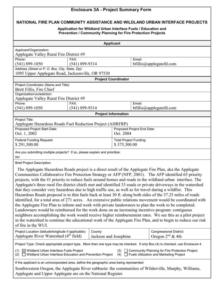
Enclosure 3A - Project Summary Form NATIONAL FIRE PLAN COMMUNITY ASSISTANCE AND WILDLAND URBAN INTERFACE PROJECTS Application for Wildland Urban Interface Fuels / Education and Prevention / Community Planning for Fire Protection Projects Applicant Applicant/Organization: Applegate Valley Rural Fire District #9 Phone: FAX: Email: (541) 899-1050 (541) 899-9314 bfillis@applegatefd.com Address (Street or P. O. Box, City, State, Zip): 1095 Upper Applegate Road, Jacksonville, OR 97530 Project Coordinator Project Coordinator (Name and Title): Brett Fillis, Fire Chief Organization/Jurisdiction: Applegate Valley Rural Fire District #9 Phone: FAX: Email: (541) 899-1050 (541) 899-9314 bfillis@applegatefd.com Project Information Project Title: Applegate Hazardous Roads Fuel Reduction Project (AHRFRP) Proposed Project Start Date: Proposed Project End Date: Oct. 1, 2002 Oct. 2004 Federal Funding Request: Total Project Funding: $ 291,500.00 $ 375,300.00 Are you submitting multiple projects? If so, please explain and prioritize: no Brief Project Description: The Applegate Hazardous Roads project is a direct result of the Applegate Fire Plan, aka the Applegate Communities Collaborative Fire Protection Strategy or AFP (NFP, 2001). The AFP identified 65 priority projects, with the #1 priority to reduce fuels around homes and roads in the wildland urban interface. The Applegate's three rural fire district chiefs met and identified 33 roads or private driveways in the watershed that they consider very hazardous due to high traffic use, as well as for travel during a wildfire. This Hazardous Roads proposal is to thin fuels back at least 30 ft. along both sides of the 37.25 miles of roads identified, for a total area of 271 acres. An extensive public relations movement would be coordinated with the Applegate Fire Plan to inform and work with private landowners to plan the work to be completed. Landowners would be reimbursed for the work done on an increasing incentive program: contiguous neighbors accomplishing the work would receive higher reimbursement rates. We see this as a pilot project in the watershed to continue the educational work of the Applegate Fire Plan, and to begin to reduce our risk of fire in the WUI. Project Location (latitude/longitude if applicable): County: Congressional District: Applegate River Watershed (4th field) Jackson and Josephine Oregon 2nd & 4th The Applegate Communities Project Type: Check appropriate project type. More than one type may be checked. If only Box (4) is checked, use Enclosure 4. Collaborative Fire Protection Strategy (1) Urban Interface Project (3) Community Planning for Fire Protection Project projectWildland (NFP-2001), referredFuels to as the (2) Wildland Urban Interface Education and Prevention Project (4) Fuels Utilization and Marketing Project Applegate Fire Plan, identified that our #1 priority out ofunincorporated the 65 recommended, If the applicant is an area, define the geographic area being represented: was to reduce fuels around homes andRiver subbasin: the communities of Wilderville, Murphy, Williams, Southwestern Oregon, the Applegate roads in the wildland urban Applegate and Upper Applegate are on the National Register. interface.Applegate Watershed Enclosure 3B (Page 1 of 3) - Project Narrative Description Applications for funding must include a narrative response that describes the proposal. Please do not submit responses longer than one page, single space, 12-pitch font. Describe project including, but not limited to: project location Address these project implementation items as anticipated outcomes applicable: measures and reporting interagency partners project relationship to community or natural landscape fire plans project time frames and income specify types of activities and equipment used amount or extent of actions (acres, number of homes, etc) environmental, cultural and historical resource requirements The Applegate River watershed encompasses nearly 500,000 acres in Southwestern Oregon, contains over 7,400 homes and 12,000 residents. Nearly every one of the unincorporated communities in the watershed has been listed as high-hazard under the National Fire Plan. In 2001 the NFP funded the Applegate Partnership's Applegate Fire Plan - a community planning project supported by over 20 local agency partners, and that is within weeks of being completed (final printing in July, 2002). This Hazardous Road project is a direct result of, and the number one recommendation to come out of the Applegate Fire Plan (AFP). More than half of the fires in the Applegate over the past 25 years have been human-caused. In assessing fire starts, it was apparent that roads played a huge part, and the AFP's project team recommended fuel reduction work along both public roads and private driveways as a number one priority, along with the 100' "defensible space" around homes. (Another 50+ specific strategic fuel reduction projects were also recommended.) The valley's three rural fire chiefs met and developed a listing of their "top hazard" roads to tackle first, based upon degree of hazard, length of roads and number of residences. Portions of thirty-three roads or driveways were identified, totaling 37.25 miles. The recommendation was that at least a 30 ft. strip on either side of these roads be thinned, thereby reducing the risk of a fire start spreading further onto private or federallymanaged lands and becoming a wildfire. This covers approximately 271 acres of land to be treated, over 60% being heavy fuels and the balance moderate fuels buildup. The Applegate Fire Plan promotes neighbors working together to reduce fuel hazards, and this project will continue this practice, in an effort to realize larger fuel breaks and buffers. Through an extensive public outreach program with help from many AFP partners, we will contact landowners on the roads identified and discuss reasons and options for treatment. Land stewardship is always our primary goal. We will provide an incentive-based reimbursement scale for private landowners to be reimbursed for the work they complete. One possible scenario is that a single participating landowner would receive 50% reimbursement, two contiguous landowners would receive 75% and three or more, 100% reimbursement for the cost of the work. Because this land is adjacent to roadways, we would anticipate that most work would consist of thinning, slashing and pruning, with disposal either by small handpiles and burning or, more likely, chipping. Landowners would be encouraged to determine their own prescriptions, with assistance from agency personnel or local watershed councils, so that the reasons and methods for treatments as well as re-entry work are learned. Documentation of this work will be promoted with before and after photos, as well as a recording of the location and total acreage of lands treated in the watershed. Participants would be encouraged to participate in effectiveness monitoring, using plot points and photos over a 2-3 treatment-cycle period. This is all part of the monitoring aspects of the Applegate Fire Plan, with photo pages and personal record sheets being included in the plan itself. We anticipate that this project will take two years to complete, with much of the first few months taken up with landowner identification and outreach. Depending upon when funding is realized, on-the-ground work would take two winters, with project closeout possible by October, 2004. Original partners in the Applegate Fire Plan were: two Resource Areas of the BLM, two National Forests, two units of Oregon Dept. of Forestry, three rural fire districts, two local watershed councils, and the Applegate Partnership. Early on in that project we added numerous departments of both Josephine and Jackson counties (e.g. building, planning, GIS, emergency services), DEQ, NMFS, USFWL, and ODFW. All are committed to continued support in the Applegate. Response: Enclosure 3B (Page 2 of 3) - Project Evaluation Criteria Applications for funding must include narrative responses that address the following four criteria. Within each criterion, subcriteria are listed in descending order of importance. Limit your responses to the areas provided. 1. Reducing Fire Risk. (40 points)) A. Describe how the proposal promotes reduction of risk in high hazard areas or communities, or natural landscapes. B. Describe how the proposed project benefits resources on federal land or adjacent non-federal land, or how it protects the safety of communities. C. To what extent does the project implement or create a cooperative (1) fuels treatment plan or (2) community fire strategy (include evidence of the plan if it already exists)? D. Explain to what extent the affected community or proponent has been involved or plans to involve the affected community in a qualified fuels education program (e.g., FIREWISE). E. Explain how the proposal (1) leads to, enhances or restores a local fire-adapted ecosystem, and/or (2) mitigates or leads to the mitigation of hazardous fuel conditions. F. How will the proposed treatments or programs be maintained in future years? Response: A greater number of fires are caused by humans in the Applegate than by lightning, and in studies during the AFP project we found that lands around homes and along roads presented the highest fire risk as well as having very high fire hazard. The Applegate's land ownership is a checkerboard pattern of private and two federal land managers. The majority of properties/locations that have been identified for this project are directly adjacent to federally managed lands. Therefore, reducing fuel hazards along these roads will help buffer and protect both the communities at risk as well as our federal forests and their resources. This Hazardous Roads project is a direct product of the Applegate Fire Plan (AFP), which is a collaboratively developed watershed-wide plan addressing 3 components: fire suppression, fuel reduction and emergency communications. More than 40 community meetings, held over a six month period by the AFP project team gathered input from residents in all of these areas. This input was included in the final fire plan, which is in it's final writing and due to be printed / distributed across the watershed in July, 2002. Residents in the Applegate have already begun fuel reduction work around their own homes this Spring (over 280 at last count) as part of the AFP, and work will continue through another grant received by ODF. This Hazardous Road project complements and strengthens what is already happening on the ground in the Applegate. Through ongoing public outreach, education, seminars and workshops and newsletters, the AFP will promote re-entry and maintenance work. Monitoring projects will track effectiveness as well as numbers and location of acres treated, both on private and federally managed lands. 2. Increasing local capacity. (30 points) A. How would the proposal improve or lead to the improvement of the local economy in terms of jobs and sustainable economic activity? How many jobs are expected to be created or retained and for how long (please distinguish between essentially yearround and seasonal jobs)? How will this proposal link to toher projects (or proposed projects) to create year-round jobs? B. To what extent will this project be offered to serve as a model for other communities or natural landscapes? C. Will biomass or forest fuels be utilized; if so, in what manner and how much? Response: In this Hazardous Roads project, each property owner will be individually contacted and the project's goals discussed in detail. A specific prescription for each property will be determined by the landowner; lists of available local forest workers, loggers, restoration specialists and portable sawmill owners will be available from the AFP so that the landowner can contract with someone they feel will do the job as specified. These lists are presently being used for the "defensible space" work that is already happening in the Applegate (the AFP will update these lists annually). Local workers have been continually busy all spring, and this roads project will add another dimension to fuel reduction work and encourage more local employment. The Applegate Fire Plan project is considered to be a 25-50 year endeavor, so as awareness grows, more and more landowners will be doing fuel reduction work, withhelp from local contractors. Individual sites and personal prescriptions will create a variety of materials being removed. Whenever possible, the project team will encourage utilization of this material for several reasons: to expose more and more people to the value of utilization of forest resources (e.g. firewood, mulch, biomass, building materials, etc.), but also to remove slash from the ground as quickly as possibly. Approximately 84% of the Applegate is rated either high or moderate fire hazard and it will take time to significantly reduce this number. We need to find every way possible to keep our valley fire-safe. Enclosure 3B (Page 3 of 3) - Project Evaluation Criteria 3. Increasing interagency and intergovernmental coordination. (15 Points) A. Describe how this project implements a local intergovernmental strategy or plan, or creates such a plan. Describe the plan if it already exists. B. Explain the level of cooperation, coordination or strategic planning through a “Local Coordination Group” for wildland fire activities, or among federal, state, tribal, local government and community organizations. List the cooperators (a detailed list of cooperators will be required for projects that are funded). Response: The Applegate Fire Plan (AFP), with it's 20+ partners, is a success story for interagency collaboration (partners are listed in the project narrative, pg. 1). These many partners plus the community team (see #4 below) all participated in the planning, writing and outreach of the AFP. Through this Hazardous Roads project and other implementaton projects of the AFP, the partners continue to work together with the community toward decreasing fire hazards in the Applegate; they realize it benefits everyone. The three fire chiefs of our rural fire districts consulted and developed the parameters of this Hazardous Roads project, and they will all assist in it's implementation. ODF will be ready for consultations and further work that private landowners might decide to take on as a result of this project. BLM, USFS, NMFS, ODFW, our local watershed councils - they will all be available to consult on this project if needed. As fuel reduction strategies were developed for the AFP, the landscape was considered as a whole, without land ownership designations. As a result, more than half of the proposed strategic projects involve multiownership, and folks are excited about this. Both BLM and the USFS are already engaging in new forms of fuel reduction projects that include their private landowner neighbors, as a direct result of the AFP's goals. While the "Local Coordination Groups" have not yet been officially designated, in theory the Applegate Partnership and the AFP staff have been filling this role over the past 6 months in the Applegate. Continued coordination after the fire plan is printed will cover funding for future on-the-ground work, public education such as workshops and newsletters, and several monitoring projects, as well as the constant strive toward more and more collaborative projects in the Applegate valley. 4. Expanding Community Participation. (15 Points) A. To what extent have interested individuals, groups, and communities been provided an opportunity to become informed and involved in this proposal? B. Describe the extent of local support or opposition for the project, including any cost-sharing arrangements. C. What are the environmental, social and educational benefits or concerns of the project? Response: The AFP set up a 12-member community group early on in the project, to assist in outreach, but also to help in the project's development. During our many community meetings, we heard tons of ideas on fuel reduction from our neighbors. The AFP team met with other local community groups, who all expressed support for the plan. During our first round of public meetings we heard issues about property rights, privacy and comercial logging. We talked straightforwardly, noting that participation in the AFP was all voluntary, and all methods of fuel reduction are welcome, including grazing or a holistic native american approach. Ground work to date has mainly been on an incentive basis, with landowners donating at least 25% of the implementation costs. The Hazardous Roads project will continue in the same vein. We will also receive inkind time from the three fire districts as well as the federal agencies (for things like wildlife consultations.). Environmentally, this Hazardous Roads project will provide a fuel break or buffer in very strategic high-risk areas, in hopes that we can buy a little more time to complete fuel reduction work on adjacent federal lands. This Hazardous Roads project will also reach out to new landowners and begin to increase their awareness of fire related issues, and hopefully introduce the word "stewardship" to them (making this a household word in the Applegate is our goal). To date the AFP and it's offshoot implementation projects have pulled the community together in both neighborhood fuel reduction work as well as the development of telephone trees and a general disaster preparedness. As the fuel reduction work snowballs throughout the valley, this and other projects will link neighborhoods even more. Enclosure 3C - Project Work Form Tasks Time Frame Responsible Party Project setup: Identify landowners, set up data base, begin public outreach, contacts and education of the project's parameters. 2-3 months initially, with ongoing as more contacts are made. Applegate Valley Rural Fire District #9, Applegate Fire Plan team Work Planning & Contracting: Scope of each landowner's work determined, contractors consulted, costs determined, agreements signed. on-going: 2 years Landowners (partner #2), Applegate Valley Rural Fire District #9, 2 Josephine County Fire Districts (partner #1), BLM, ODF, USFS, contractors On-the-ground work is completed, property by property. 2 winter/spring work seasons Landowners & contractors Work verified as complete Throughout project: 2-4 weeks after work is done. Applegate Valley Rural Fire District #9, Williams Rural Fire District, Rural/Metro Fire District Fuel reduction work tracked Throughout project Applegate Fire Plan team, as part of project monitoring Reimbursements to landowners Throughout project. Applegate Valley Rural Fire District #9 Top of Form Enclosure 4D - Project Budget Cost Category Description Personnel On-site Consultations P/T project manager: 2 years Subtotal Federal Agency $5,000.00 $5,000.00 Applicant $0.00 $40,000.00 $40,000.00 Partner 1 Partner 2 Total $0.00 $0.00 $10,000.00 $40,000.00 $50,000.00 $0.00 $0.00 $0.00 $0.00 $0.00 $0.00 $0.00 $300.00 $0.00 $300.00 $0.00 $0.00 $0.00 $0.00 $0.00 $0.00 $0.00 $0.00 $3,000.00 $1,500.00 $4,500.00 $0.00 $50,100.00 $23,400.00 $73,500.00 $0.00 $200,400.00 $93,600.00 $294,000.00 $5,000.00 $5,000.00 Fringe Benefits Subtotal $0.00 $0.00 $0.00 Travel mileage @ $0.345/mile $150.00 $0.00 $150.00 Subtotal $150.00 $0.00 $150.00 Equipment Subtotal Supplies Mail 2 flyers to 7400 homes Outreach/6 meetings Subtotal Contractual HeavyFuel Red.:167 ac @$1200 Mod. Fuel Red.:104 ac @$900 Subtotal $0.00 $0.00 $3,000.00 $1,500.00 $4,500.00 $0.00 $150,300.00 $70,200.00 $220,500.00 Other Administration (10%) Subtotal Total Costs Project (Program) Income1 1 $0.00 $0.00 $0.00 $26,500.00 $0.00 $0.00 $0.00 $26,500.00 $0.00 $26,500.00 $5,150.00 $291,500.00 $5,150.00 $73,500.00 $375,300.00 $0.00 $0.00 $0.00 $0.00 $0.00 $26,500.00 Program income is the gross revenue generated by a grant or cooperative agreement supported activity during the life of the grant. Program income can be made by recipients from fees charged for conference or workshop attendance, from rental fees earned from renting out real property or equipment acquired with grant or cooperative agreement funds, or from the sale of commodities or items developed under the grant or cooperative agreement. The use of Program Income during the project period may require prior approval by the granting agency.
