Enclosure 3A - Project Summary Form
advertisement
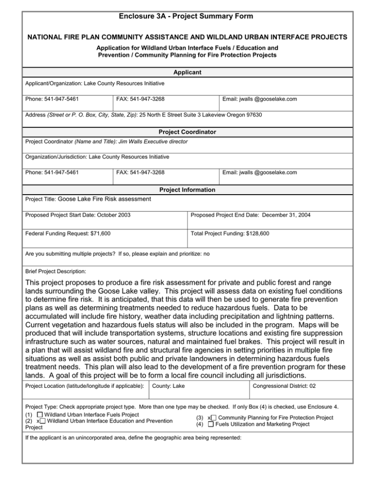
Enclosure 3A - Project Summary Form NATIONAL FIRE PLAN COMMUNITY ASSISTANCE AND WILDLAND URBAN INTERFACE PROJECTS Application for Wildland Urban Interface Fuels / Education and Prevention / Community Planning for Fire Protection Projects Applicant Applicant/Organization: Lake County Resources Initiative Phone: 541-947-5461 FAX: 541-947-3268 Email: jwalls @gooselake.com Address (Street or P. O. Box, City, State, Zip): 25 North E Street Suite 3 Lakeview Oregon 97630 Project Coordinator Project Coordinator (Name and Title): Jim Walls Executive director Organization/Jurisdiction: Lake County Resources Initiative Phone: 541-947-5461 FAX: 541-947-3268 Email: jwalls @gooselake.com Project Information Project Title: Goose Lake Fire Risk assessment Proposed Project Start Date: October 2003 Proposed Project End Date: December 31, 2004 Federal Funding Request: $71,600 Total Project Funding: $128,600 Are you submitting multiple projects? If so, please explain and prioritize: no Brief Project Description: This project proposes to produce a fire risk assessment for private and public forest and range lands surrounding the Goose Lake valley. This project will assess data on existing fuel conditions to determine fire risk. It is anticipated, that this data will then be used to generate fire prevention plans as well as determining treatments needed to reduce hazardous fuels. Data to be accumulated will include fire history, weather data including precipitation and lightning patterns. Current vegetation and hazardous fuels status will also be included in the program. Maps will be produced that will include transportation systems, structure locations and existing fire suppression infrastructure such as water sources, natural and maintained fuel brakes. This project will result in a plan that will assist wildland fire and structural fire agencies in setting priorities in multiple fire situations as well as assist both public and private landowners in determining hazardous fuels treatment needs. This plan will also lead to the development of a fire prevention program for these lands. A goal of this project will be to form a local fire council including all jurisdictions. Project Location (latitude/longitude if applicable): County: Lake Congressional District: 02 Project Type: Check appropriate project type. More than one type may be checked. If only Box (4) is checked, use Enclosure 4. (1) Wildland Urban Interface Fuels Project (3) x Community Planning for Fire Protection Project (2) x Wildland Urban Interface Education and Prevention (4) Fuels Utilization and Marketing Project Project If the applicant is an unincorporated area, define the geographic area being represented: Enclosure 3B (Page 1 of 3) - Project Narrative Description Applications for funding must include a narrative response that describes the proposal. Please do not submit responses longer than one page, single space, 12-pitch font. Describe project including, but not limited to: project location Address these project implementation items as anticipated outcomes applicable: measures and reporting interagency partners project relationship to community or natural landscape fire plans project time frames and income specify types of activities and equipment used amount or extent of actions (acres, number of homes, etc) environmental, cultural and historical resource requirements This project will encompass public and private lands surrounding the Goose Lake Valley in Lake County Oregon. The purpose of this project is to analyze the fire risk to these lands. This will be accomplished by mapping the locations of structures and other improvements, the transportation system, existing hazardous fuels and vegetation conditions in the wildland urban interface in Goose Lake valley. Part of the project will be to gather all existing information into a comprehensive database. This information will then be analyzed to ascertain what information is missing. Those areas with incomplete information will then be surveyed to fill in the gaps. From this data it will be possible to assign a risk rating to various areas. It will also be possible to use the data to develop prevention plans and fuels treatment projects where necessary. A goal will be to create a local fire council made up of state and federal wildland fire agencies, rural fire departments local government agencies as well as representatives of both industrial timberlands and nonindustrial lands. Also the county assessor, and land use planning functions of Lake County play a significant role in fire planning and prevention, as well as providing major data related to land ownerships. This council would bring together all of the stakeholders in fire prevention and suppression in this area. Each of these groups has information and plans for lands in their area of responsibility but a common database of all of this information does not exist. By bringing all of these groups together in the planning stages, a more coordinated response in times of emergency will be possible. Another product of this project and the fire council would be to coordinate and cooperate in a wildland fire training program. The database will include a listing of personnel, their qualification and equipment. The fire council would also allow increased understanding of laws, rules, regulations and policies that each of the agencies operates under. The partners in this program will be the Lakeview Interagency Fire Center, which is made up of the Fremont-Winema National Forest, the Lakeview District of the Bureau of Land Management, U.S. Fish and wildlife Service Sheldon-Hart Mountain Refuges, Klamath-Lake District Oregon State Department of Forestry, Lakeview Fire Department, Lakeview Rural Fire Department, Thomas Creek Westside Fire Department, Pine Creek Fire Department, Oregon State Parks and Oregon Department of Transportation. In addition, private landowners will be encouraged to participate and be a part of the fire council. At this time there is not a coordinated fire plan that covers this area. Some of these lands are not included in any fire protection district at this time. While each of the agencies have some plans for lands within their jurisdiction there is a need for a coordinated plan. There are also areas with no inventory of structures, roads fuels and vegetation. In other areas the inventory is either incomplete or out of date. A great efficiency could be achieved by gather and collating this information in one database available to all of the agencies. This would be a tremendous asset to use in allocating resources in multiple fire situations. The projected time frame for this project is as follows. Data gathering would begin in early 2004. During the summer of 2004, ground verification of existing data and addition data gathering would take place. At this time agencies as well as private landowner would be brought together to form the local fire council. During the fall of 2004 the data would be assemble into maps ect. Analysis would be preformed to determine training needs. Training would be planned and carried out prior to the start of the 2005 fire season. During the winter of 2004-2005 the risk assessment would be completed and prevention planning would be started. This would include fire prevention education in the local schools. While this project will not produce any direct income, the potential for savings in property and human loss by increasing fire safety is tremendous. This work will serve as a template for similar planning effort in the remainder of the county in future years. This initial project will cover approximately 100,000 acres of public and private land. The number of homes and other structures in this area is unknown at this time, because of the lack of a complete inventory. Because this project will not involve any ground disturbing activity, there will be no requirement for an environmental assessment. Part of the mapping may include structures or areas with historical or cultural significance. Response Enclosure 3B (Page 2 of 3) - Project Evaluation Criteria Applications for funding must include narrative responses that address the following four criteria. Within each criterion, subcriteria are listed in descending order of importance. Limit your responses to the areas provided. 1. Reducing Fire Risk. (40 points)) A. Describe how the proposal promotes reduction of risk in high hazard areas or communities, or natural landscapes. B. Describe how the proposed project benefits resources on federal land or adjacent non-federal land, or how it protects the safety of communities. C. To what extent does the project implement or create a cooperative (1) fuels treatment plan or (2) community fire strategy (include evidence of the plan if it already exists)? D. Explain to what extent the affected community or proponent has been involved or plans to involve the affected community in a qualified fuels education program (e.g., FIREWISE). E. Explain how the proposal (1) leads to, enhances or restores a local fire-adapted ecosystem, and/or (2) mitigates or leads to the mitigation of hazardous fuel conditions. F. How will the proposed treatments or programs be maintained in future years? Response: A. The Fremont National Forest and Lakeview District, Bureau of Land Management in Lake County have a history of frequent large fires. There has been an increase in the number of homes constructed adjacent to National Forest and BLM land. This project will begin to address the risk to both homes, forest and range lands. This will be accomplished by identifying those areas that are at greatest risk from wildfire and will look for methods to mitigate that risk. B. One aspect of this proposal will be a prevention and education project designed to reduce the risk of human caused fires in the wildland urban interface in the Goose Lake Valley. This project will also increase cooperation and understanding between the various fire service agencies that will lead to greater efficiencies. This will in turn provide better protection to both federal and private lands. C. This project will create a local fire council made up of representatives of all the fire agencies ,and local government functions , as well as private land owners. This project will provide the beginning of a coordinated community fire strategy. This strategy will include prevention, education and suppression planning and training. D. This proposal is supported by all of the local wildland and structural fire agencies. Lake County Resources Initiative (LCRI) will serve as the coordinating body to bring the agencies together as well as private landowners. All of the agencies recognize the need for this type of planning, but are limited by available funding and personnel to accomplish it. E. This project will gather information on existing hazardous fuels within the study area. A system will be developed to assign a risk rating to each area. This will lead to coordinated fuels reduction projects in the future. These projects could include the use of prescribed fire to reduce the existing fire hazard and also improve and restore habitat. F. Once the fire council is formed and active it will be positioned to seek funding from a variety of sources to carry out the work identified in the initial study in a coordinated manner. 2. Increasing local capacity. (30 points) A. How would the proposal improve or lead to the improvement of the local economy in terms of jobs and sustainable economic activity? How many jobs are expected to be created or retained and for how long (please distinguish between essentially yearround and seasonal jobs)? How will this proposal link to toher projects (or proposed projects) to create year-round jobs? B. To what extent will this project be offered to serve as a model for other communities or natural landscapes? C. Will biomass or forest fuels be utilized; if so, in what manner and how much? Response: A. This project will create some jobs initially to gather the information needed to create a database of existing condition as well a prevent ion and education plan. It is anticipated that future jobs would be created to do needed hazardous fuels reduction work. While some of the planning work can be accomplished in the winter, most of the inventory work will need to done during the summer months. Lake County Resources Initiative (LCRI) has been working for the past two years to provide training and contracting opportunities to local workers. This project will provide the means to continue efforts in this area. This project will also provide fire suppression and contracting training to local contractors to assist them in becoming more competitive for contract opportunities in both fuels projects and fire suppression work. B. This project will focus on the Goose Lake Valley. It is anticipated this project will serve as a model that will be used in other areas of Lake County where applicable. LCRI along with its partner Sustainable Northwest is part of a network of communities in the northwest that routinely share information and lessons learned. Any information gained from this project would be available to the public. LCRI will actively seek to share this information. C. LCRI is involved in a feasibility study for a biomass cogeneration plant in Lakeview. We are also doing a feasibility study for a post and pole plant in southern Lake County. Both of these efforts are aimed at providing local jobs as well as finding uses for by products of hazardous fuels reduction and forest restoration projects. Much of the area covered by this study has been invaded by Juniper. It is hoped that by finding a use for Juniper as well as small diameter trees, fire hazard can be reduced, jobs created and healthy forests restored. Enclosure 3B (Page 3 of 3) - Project Evaluation Criteria 3. Increasing interagency and intergovernmental coordination. (15 Points) A. Describe how this project implements a local intergovernmental strategy or plan, or creates such a plan. Describe the plan if it already exists. B. Explain the level of cooperation, coordination or strategic planning through a “Local Coordination Group” for wildland fire activities, or among federal, state, tribal, local government and community organizations. List the cooperators (a detailed list of cooperators will be required for projects that are funded). Response: A. This project will create a local intergovernmental fire council. All of the local fire agencies agree that there is a need for such a council. This need was made more evident by wildfires during the summer of 2002 that impacted large areas of federal and private land and threatened many homes. Reviews after the fires pointed out many areas where improvements could be made such as setting priorities for use of suppression resources as well as more efficient means of sharing information. It is evident that there is a need for a coordinated planning process that shares information across all of the fire protection jurisdictions. This coordination needs happen prior to the fire and not after. The State and Federal agencies are limited in their ability to accomplish this project by both funding and staffing levels. In addition, this project will provide a vehicle to coordinate hazardous fuels treatment project across ownership boundaries. This will increase the effectiveness of the treatments as well as being more cost efficient. The local and rural fire departments are staffed largely by volunteers and therefore lack time to take on a task of this magnitude. LCRI will take the lead for this project. By using the expertise and knowledge of all of the partners a coordinated plan will be produced. B. This project is supported by the Fremont-Winema National Forest, Lakeview District Bureau of Land Management, Oregon State Department of Forestry, Klamath-Lake District, Lakeview Volunteer Fire Department, Lakeview Rural Fire Department, Thomas Creek Westside Fire Department New Pine Creek Fire Department, town and county government bodies and many individuals and companies who own or manage land adjacent to federal lands. All of the agencies have agreed to participate in this project if it is funded. A major part of this proposal will be to bring together all of the existing information in one location. The second part will be to gather additional information where gaps exist. 4. Expanding Community Participation. (15 Points) A. To what extent have interested individuals, groups, and communities been provided an opportunity to become informed and involved in this proposal? B. Describe the extent of local support or opposition for the project, including any cost-sharing arrangements. C. What are the environmental, social and educational benefits or concerns of the project? Response: A. All local fire agencies have been invited to participate in this project. Discussions have been held with most of the large industrial timberland owners and some of the owners of small parcels. Should this proposal be funded, a concentrated effort will be made to recruit all landowners to become involved in this project. This proposal will only involve the community of Lakeview and surrounding areas. B. There is great support for this project from the local fire protection community as well as landowners in the wildland urban interface. The Town of Lakeview as a timberland owner supports this project as does Lake County. The Forest Service and Bureau of Land Management will provide GIS mapping for this project as well as providing existing vegetation maps for the project. The Oregon State Department of Forestry will provide* information on land ownership and fuels status for private lands, as well as assisting with data gathering. The local structural departments will share existing information on locations of structures. The Forest Service will provide historical fire and weather data as well as fuels data for federal lands. There is no known opposition to this project. C. This project will have multiple benefits. It is expected that in future years this project will lead to hazardous fuels reduction projects which will reduce environmental and economic loses caused by wildfire. These fuels projects will create some opportunity for employment as well as restoring the forest to a more natural condition. The prevention plan that will be created will involve the local educational community in fire prevention training. It is also possible that high school science classes could participate in fuels reduction planning and restoration projects. There may be summer job opportunities created for local students as well as contractors. We feel that the results of this project will have a positive impact on the entire community. *Lake County Assessor maintains database of land ownership information that ODF uses for assessments for Fire Protection on private lands. This information will form the foundation for other applications using GIS, and other analysis tools for Fire Planning, Prevention, and education. Enclosure 3C - Project Work Form Tasks Time Frame Responsible Party Begin Fire Council Organization October –December 2003 Lake County Resources Initiative Gather existing information from participating partners and begin identifying information gaps. Continue Fire Council organizing. January – March 2004 Lake County Resources Initiative Oregon State Department of Forestry Fremont national Forest Lakeview BLM Rural Fire Departments Inventory lands for missing data and verification of existing data. Continue Fire Council organization April – July 2004 Oregon State Department of Forestry Fremont National Forest Lakeview BLM Rural Fire Departments Lake County Resources Initiative Develop risk assessment, begin prevention plan, training plans, and continue Fire Council development. July – September 2004 Lake County Resources Initiative Oregon State Department of Forestry Fremont National Forest Lakeview BLM Rural fire Departments Complete all plans and share information Prepare to implement plan prior to fire season. October – December 2004 Lake County Resources Initiative Fremont National Forest Lakeview BLM Rural Fire Departments Enclosure 3D Project Budget Cost Category Description Personnel Subtotal Federal Agency NFP $22,500 Applicant LCRI $22,500 Partner 1 ODF $10,000 $10,000 Partner 2 Total Local Fire Dept. FS/BLM $20,000 /$20,000 $5,000 $20,000 / $20,000 $5,000 $77,500 Fringe Benefits $4,800 Subtotal $4,800 $4,800 Travel $3,500 Subtotal Equipment GPS Equip Computer Software Subtotal $3,500 $3,500 $600 $400 $1,000 $1,000 Supplies $500 Subtotal Contractual Consultants ODF Subtotal $500 $500 $20,000 $10,000 $30,000 $30,000 Other Admin Cost Rent/Utilities Subtotal $9,300 $2,000 $2,000 Total Costs $71,600 $2,000 $9300 $11,300 $10,000 $20,000 $20,000 $5,000 Project (Program) Income1 (using deductive alternative) 1 Program income is the gross revenue generated by a grant or cooperative agreement supported activity during the life of the grant. Program income can be made by recipients from fees charged for conference or workshop attendance, from rental fees earned from renting out real property or equipment acquired with grant or cooperative agreement funds, or from the sale of commodities or items developed under the grant or cooperative agreement. The use of Program Income during the project period may require prior approval by the granting agency. $128,600
