Project Summary Form Id Number 2006-014
advertisement
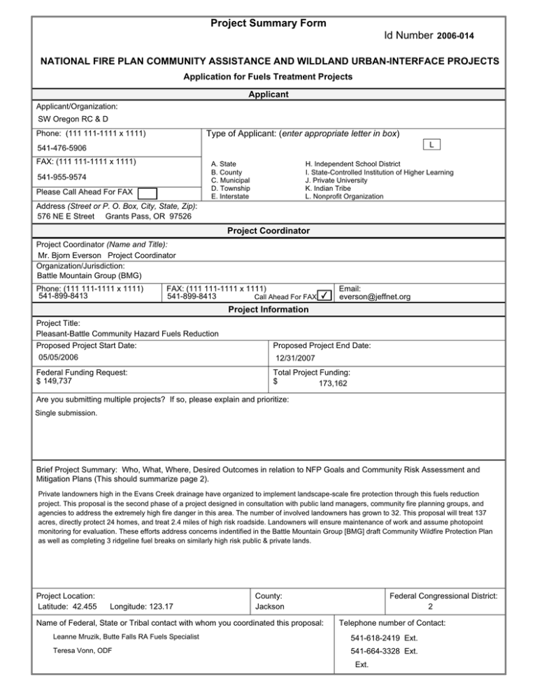
Project Summary Form Id Number 2006-014 NATIONAL FIRE PLAN COMMUNITY ASSISTANCE AND WILDLAND URBAN-INTERFACE PROJECTS Application for Fuels Treatment Projects Applicant Applicant/Organization: SW Oregon RC & D Phone: (111 111-1111 x 1111) Type of Applicant: (enter appropriate letter in box) L 541-476-5906 FAX: (111 111-1111 x 1111) A. State B. County C. Municipal D. Township E. Interstate 541-955-9574 Please Call Ahead For FAX H. Independent School District I. State-Controlled Institution of Higher Learning J. Private University K. Indian Tribe L. Nonprofit Organization Address (Street or P. O. Box, City, State, Zip): 576 NE E Street Grants Pass, OR 97526 Project Coordinator Project Coordinator (Name and Title): Mr. Bjorn Everson Project Coordinator Organization/Jurisdiction: Battle Mountain Group (BMG) Phone: (111 111-1111 x 1111) 541-899-8413 FAX: (111 111-1111 x 1111) 541-899-8413 Call Ahead For FAX ✔ Email: everson@jeffnet.org Project Information Project Title: Pleasant-Battle Community Hazard Fuels Reduction Proposed Project Start Date: 05/05/2006 Federal Funding Request: $ 149,737 Proposed Project End Date: 12/31/2007 Total Project Funding: $ 173,162 Are you submitting multiple projects? If so, please explain and prioritize: Single submission. Brief Project Summary: Who, What, Where, Desired Outcomes in relation to NFP Goals and Community Risk Assessment and Mitigation Plans (This should summarize page 2). Private landowners high in the Evans Creek drainage have organized to implement landscape-scale fire protection through this fuels reduction project. This proposal is the second phase of a project designed in consultation with public land managers, community fire planning groups, and agencies to address the extremely high fire danger in this area. The number of involved landowners has grown to 32. This proposal will treat 137 acres, directly protect 24 homes, and treat 2.4 miles of high risk roadside. Landowners will ensure maintenance of work and assume photopoint monitoring for evaluation. These efforts address concerns indentified in the Battle Mountain Group [BMG] draft Community Wildfire Protection Plan as well as completing 3 ridgeline fuel breaks on similarly high risk public & private lands. Project Location: Latitude: 42.455 Longitude: 123.17 County: Jackson Name of Federal, State or Tribal contact with whom you coordinated this proposal: Federal Congressional District: 2 Telephone number of Contact: Leanne Mruzik, Butte Falls RA Fuels Specialist 541-618-2419 Ext. Teresa Vonn, ODF 541-664-3328 Ext. Ext. Project Narrative Description Applications for funding must include a narrative response that describes the proposal. Please do not submit responses longer than one page, single space, 12-pitch font. Describe project including, but not limited to: x project relationship to the community risk assessment and x project location (e.g., Watershed, Address mitigation plan neighboring community) these items as applicable: x anticipated outcomes x amount or extent of actions (acres, number of homes, etc.) x project timeline and matching or contributed funds x community partners and their role(s) x proponent’s ability to complete project For this project, explain the level of cooperation, coordination or strategic planning, through a “Local Coordination Group.” If you have not worked with a local coordination group, why not? Continual updates to LCG coordinators & meetings with partner BLM providing 2 year representation. Is this project adjacent to a current prescribed burn project on federal lands or to one that is planned within the next three years? (Yes/No) Yes Please indicate planned treatments and associated acres: * Treatment Thinning Acres 114 Treatment Mastication/Mowing Acres 23 Treatment Clipping Acres 0 Treatment Hand Pile Burning Acres 60 If you have a treatment type other than standard types above: Pruning Other 1 Delineate/ 2nd Entry Acres 137 Other 2 Acres 12 The Battle Mountain Group proposes landscape-scale fire protection with fuels reduction between Pleasant Creek-Sykes Creek & other sites. A Second Phase was intended by the Old Battle Mouhtain Fire Road Group, [OBMFRG] to also include large roadside connectivity. This depended upon an active BLM partner and private outreach offered by landowners of the Old Battle Mt. Fire Road Group. We have been fortunate with both. 20+ new landowners show the success of this exciting partnership idea. A. The SW RC & D measures the quality and quantity of outreach performed by partners, and supports this coordinated fuels reduction project as fiscal sponsor. The detail of collaborative planning for both "Phase 1" [OBMFRG 2004], & this Pleasant-Battle Proposal- 2005 is unusual and commendable. Together this Group has developed mutual, clear, on-the-ground plans for treatment types in specific units. These are mapped and ground-truthed in detail, protecting of large blocks of contiguous managed lands. B. Professional and community partners support this proposal and have helped develop it over the past year; benefits to & from these members include: review & consultation/education with 7BFPP to develop a risk assessment map & draft Community Wildfire Protection Plan ; ease of BLM planning for integrated landscape-scale projects across several years; allows for concentration ODF project planning in conjunction with BMG/BLM treatment maps; supports Fire Dist.#6 sub-station effort. All private & public partners have 'put their eggs in this basket', collaborating to help each other design a landscape scale project of mutual benefit and protection. C. Special outreach by the Battle Mountain Group has added 20+ new landowners, with 414+ more acres under agreement, and 16 new properties. This BMG hazard reduction treatment protects 24 homes, & 2.4 miles of direct high-risk road frontage. Interest by new people and design outreach by Battle Mt. neighbors has exceeded all expectations. This proposal links with approximately 860 proposed hazardous fuels reduction acres identified by the BLM with planned implementation starting Spring 2006, with 97 acres identified on private land under Phase One [grant tentatively selected to be funded for 2005], & approximately 70 acres of contiguous defensible space already completed by landowners. All treatment ares proposed for private land were strategically identified and based on existing fuels hazard and wildfire risk. Mapping of all treatment sites is complete and will assist in identification of future fuels reduction projects within the Pleasant Creek drainage. D. Through meetings and on-site tours, the Landowner Lead and Project Coordinator, with support from the BLM, have developed an extensive project map. The BMG continues to meet together with new landowners. Fiscal, filing, and reporting processes are being worked out now, and this "second step" is seamless. Project Coordinator & Lead have discussed prescriptions with new & old landowners, & open discussion with all partners in meetings refines treatment details by consensus. Final GPS & flagging by Landowner Lead & Proj.Cord., with each landowner on-site, will determine the actual acreage planned as mapped. E. The Battle Mt. project personally engages landowner participants [and all others] in design planning. Site-visits with neighbors view existing thinning, to see how it looks & works; education in meetings includes: layout, mapping, working vocabulary, science and monitiring, & silviculture theory. Fire specific ODF video[we now have our own copy] presentations, and species ID are sample meeting topics. BMG has an 'archiveist' maintaining all handouts, Power Points, minutes, & notes. Data, decisions, and cookies are shared by all members at surprisingly regular meetings. F. BMG landowners & Project Cordinator share responsibility for establishing 3 year photopoint monitoring plots. Outreach skills increase in core members; fuels reduction educational materials & prescription design tools are archived for further neighborhood group development. 2nd year maintenance treatment which includes delineation of the total acreage forms a large part of the BMG landowner match in this proposal. Project Evaluation Criteria Applications for funding must include narrative responses that address the following three criteria. Be sure you address every one briefly, yet thoroughly. Limit your responses to the area provided. 1. Reducing Hazardous Fuels (50 points) A. Describe the community infrastructure that will be protected. B. Explain how the proposal reduces fire behavior in high hazard areas by describing the fuels to be disposed or removed, and the techniques and timing of the treatments. C. How will the proposed treatments be maintained in future years? D. How will you use multi-party monitoring to improve this and future projects? Response: A. The Battle Mountain Group has grown up from the OBMFRG, with a new name and new private and professional partners. We retain all original members and the basic formative structures of the Old Battle Mountain Fire Road Group: mainly that a willingness to perform treatments across boundaries is just good sense and good neighbors, that all have a say, and that partner landowners & managers have a personal veto for treatments on lands in their care. Professional partners guide the landowner base in treatment design, risk assessment, CWPP, fire protection concerns. We continue to be pleased and sometimes tickled with our diversity, and the partnerships continue to grow. Local trust in neighbor-designed prescriptions is huge. B. Field team BLM-BMG has identified fuel loads, additional private-public interface, & connective zones on-the-ground. Chainsaw and machine thinning, handpiling and chipping by a crew in a workforce-training program begins in Spring 2006. Private and public treatment specialists have collaboratively designed mutually beneficial treatments that enhance each partners' contiguous fuels reduction projects. The Workplan begins Spring 2006 with roadside & upland fuels treatments, primarily small poles and brush removal in mixed hardwood-conifir stands with immediate burning, chipping, piling. Pruning in 12 roadside acres is an additional layered treatment. One ridgetop shaded fuel break between Sykes Ck. and Pleasant Ck., and 2 other ridgetops will be completed by hand and machine throughout Summer-Winter 2006, with chipping or piling, and be burnt in pring 2007. C. BMG landowners assume responsibility for a 'second entry' maintenance, and will survey & delineate the 137 treated acres to determine 'highest need' during 2007. Acres will be selected to the amount pledged and treated in 2007-8. This unusual match significantly increases long-term project value & fuel hazard reduction, but this is an unsusally responsible group of landowners. Roadside treatments meet ODF 20-year no-entry standards, and BLM & private machine treatments will match or exceed this. Private landowners will burn piles in Spring 2006 & Winter 2006-7. Chipping will occur at all points where mulch is beneficial in reducing annual fuels, and may proceed almost all year. The core landowners continue re-entry thinning on their own, [as before any grants were proposed], that is, almost constantly. 'New' landowners include professional woodcutters & contractors who also are comfortable doing or supporting maintenance work. Members unable to perform their own maintenance work have already found willing neighborly help. Detail [pruning], and intensity [roadside thinning, shaded fuel-break] in initial treatments reduces the volume of maintenance work, helping make this landowner-based offer practical. D. Battle Mountain Group landowners and Project Coordinator commit to establishing photopoint monitoring sites within the treatment project to be maintained a minimum of 3 years. Sociometric and physical quantities will be collected and tabulated for a Final Report. Multi-party is built into the Battle Mountain Group, is the essence of this group; active professionial and private partners will map past & future treatments, to provide visual perspective for final reports quantitified to NFP standards. A very active group, Battle Mountain principals intend further outreach, and enjoy sharing lessons learned; the BMG intentionally works to accept input and partnership to constantly improve outreach methods for their own and others' projects. Local landowners willing to host treatment 'tours' increases interest. Finalization of our Community Wildfire Protection Plan includes risk assessment mapping as part of 2006 general Project Mapping, and will help us to meet FPP Mitigation Plan standards.This is a substantial base for future project development or use. Project Evaluation Criteria 2. Increasing Local Capacity (25 points) A. How would the proposal improve or lead to the improvement of the local economy in terms of jobs and sustainable economic activity? B. How many jobs are expected to be created or retained and for how long? (Please distinguish between essentially year-round and seasonal jobs). C. What tools and skills will be gained or utilized as a result of this project? D. Will biomass be utilized; if so, in what manner and how much? Response: A. Support from both 2B Forests & Lomakatsi workforce-training contractors adds to BMG options. This increased local capacity leads to a stabilized workforce, generating a vested interest in community. Workers trained to see science-based prescriptions provide superior quality work, are in higher demand, and work longer. Augments local small contractors cash flow helping to retain machine & hand capacity locally. Retains important scale-appropriate machines, [large chippers and 5 small masticators], available in the area for additionnal fuels reduction. B. 6+ workers and 2 landowners augment other professional woods work to meet a full time definition. They remain available as local woods professionals with multiple skills providing employment nearly year-round in forest management, their primary management task being fuels reduction. C. Multiple skills accrue to workers, with certification including species-driven restoration and fuels reduction, chipper, & project prescription design. Significant outreach and implimentation skills are gained by BMG, who seek to encourage grass roots projects with multiple neighbors. Intents of the OBMFRG to "replicate treatments in surrounding ... areas" has succeeded with this proposal, & 'next steps' are being considered. D. No biomass fuels are utilized; some small diameter shaded fuel-break salvage may be possible with Summit Wood Products; limited firewood salvage; all slash is chipped or piled & burned. 3. Demonstrating Community and Intergovernmental Collaboration (25 Points) A. How will this project implement a community risk assessment and mitigation plan? Include name of plan, date it was prepared, and local contact to get a copy of the plan if requested. B. How has this treatment been coordinated with adjacent landowners and local/State/Tribal/Federal agencies? C. Identify the cooperators/partners involved in implementation of this project. D. Describe the extent of current local support for the project, including any cost-sharing agreements. Response: A. This proposal meets objectives of the draft BMG CWPP, and project design is correlated with initial risk assessment. Completed CWPP risk assessment in Winter 2005-Spring 2006 is a required part of design, layout, & mapping for this project, & includes previous treatment evaluation. This neighborhood group falls under the 7 Basins Fire Planning Project general guidelines, and supliments those goals. This draft Mitigation Plan is available from Gail Perritti, 541-830-3781. B. Ideas & input for this proposal were initially solicited from professional partners in early 2004. The team of BLM, Landowner Lead, and Project Coordinator regularly exchange information, sharing intents & decisions with all partners. Regular Battle Mountain Group meetings have been held in Fall/Winter/Spring 2004-5. Proposed units have been selected by BLM-BMG teams, with resulting maps & acreages. Landowners have been hosted and informed by neighbors, door-to-door outreach convincing neighbors of the benefits of mutual treatments & creating a working neighborhood network. ODF coordinates its efforts & funds with proposed BMG & BLM projects, & reaches a large private audience with quality educational tools, opportunities, & information. C. SW RC & D Amy Wilson 476-5906 ODF Teresa Vonn 664-3328 BMG Chair Leonard Bricker 582-9775 BLM Leanne Mruzik 618-2419 7 Basin FPP Gail Perrotti 830-3781 ProjCor Bjorn Everson 899-8413 Fire Ds. #6 Bill Fuller 582-0678 7BWC Paul Howell 941-3856 D. Large Landowner Match delineats & performs 'second entry' maintenance, outreach, one half of field administration, fire vehicle turnouts, and burning, & totals $22325. Other Match $950. Possible cost offset with salvage @ $2000. Project Work Form Tasks Project Design with Battle Mountain partners; mapping integration of new members, ODF treatments, & extensive BLM projects. Layout, GPS, and flagging. Monitor acreage. Cordination of Landowners & Crew. Photopoints established. Time Frame Responsible Party Battle Mountain Group: Landowner Lead (LL) & BLM Partner 2004 to present Battle Mountain Group: Landowner Lead (LL) & Proj. Coord. Spring 2006-Spring 2007 Hand treatment, pile, chip Machine treatments; Local private workforce training contractor, local machine contractors Spring 2006 - Spring 2007 Treatment Implememtation & Compliance; onsite coordination of logistics; Training & verification; Risk Assessment; Project Coordinator Spring- Fall 2006 Ridgeline fuels break and connecting sections Erosion control Local private contractors Fall 2006 Private local workforce-training contractors Burn handpiles; delineate Maintenance Entry acres Winter2006-Fall 2007 BMG landowners Neighborhood/Partner Outreach, Site Tours, Media Ops, Phase 3 Roundtable Battle Mountain Group, Project Coordinator Spring 2007 Project Coordinator Final Reports Project Potluck Photopoint Monitoring (3 years), & Maintenance Entry Winter 2007-8 Battle Mountain Group Partners Battle Mt. Group Landowners Project Budget Battle Mt. Group Cost Category Description Federal Agency Applicant BLM Partner 1 Labor Contractor Partner 2 Total Partner 3 Personnel Thin, flag, chip, prune, Layout, GPS, Maps, Sup. Subtotal $76,400 $0 $0 $0 $0 $76,400 $7,562 $0 $0 $0 $0 $7,562 $83,962 $0 $0 $0 $0 $83,962 $0 $0 $35,700 Fringe Benefits OPE $35,700 $0 $0 $0 $0 $0 $0 $0 $0 $0 $35,700 $0 $0 $0 $35,700 $0 $250 $0 $0 $700 $950 $0 $0 $0 $0 $0 $250 $0 $0 $0 $700 $950 $3,000 $0 $0 $0 $0 $3,000 $12,075 $0 $0 $0 $0 $12,075 $15,075 $0 $0 $0 $0 $15,075 $0 $0 $0 $0 $0 $0 $0 $0 $0 $0 $0 $0 $0 $0 $0 $0 $0 $0 $6,000 $0 $0 $0 $0 $6,000 $9,000 $0 $0 $0 $0 $0 $9,000 $15,000 $0 $0 $0 $15,000 BMG MATCH-Burn, OR, M $0 $0 $9,650 $0 $0 $9,650 BMG MATCH-Maint. Entr $0 $12,825 $0 $0 $12,825 $0 $0 $0 $22,475 $0 $0 $22,475 $149,737 $250 $22,475 $0 $700 $173,162 $0 $0 $0 $0 $0 $0 Subtotal Travel Monitoring, Field Admin. $0 Subtotal Equipment Chipper, rental Machine Thinning 23 ac Subtotal Supplies Subtotal Contractual SW RC & D Fiscal Oversi Project Coordination Subtotal Other Subtotal Total Costs Project (Program) Income1 ___________________________________ 1 Program income is the gross revenue generated by a grant or cooperative agreement supported activity during the life of the grant. Program income can be made by recipients from fees charged for conference or workshop attendance, from rental fees earned from renting out real property or equipment acquired with grant or cooperative agreement funds, or from the sale of commodities or items developed under the grant or cooperative agreement. The use of Program Income during the project period may require prior approval by the granting agency.
