JDiBrief - Analysis Vulnerable Localities Index: SUMMARY (1 of 5)
advertisement
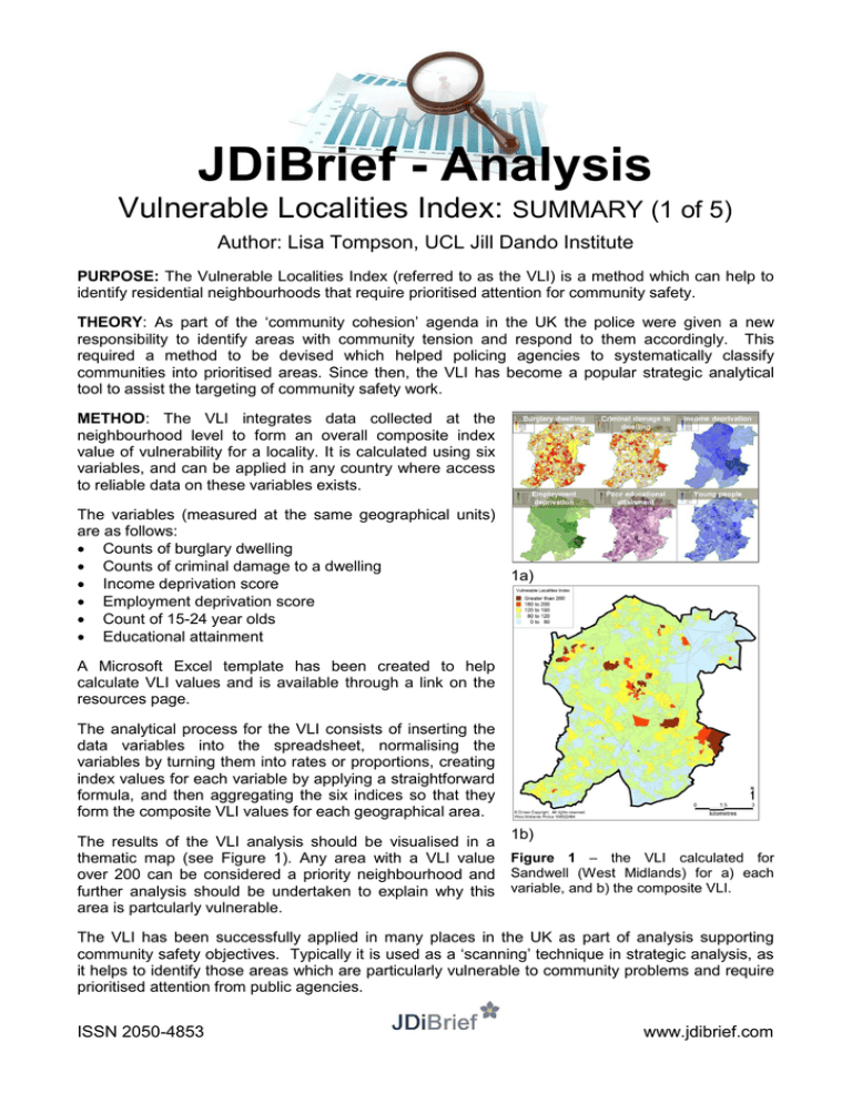
JDiBrief - Analysis Vulnerable Localities Index: SUMMARY (1 of 5) Author: Lisa Tompson, UCL Jill Dando Institute PURPOSE: The Vulnerable Localities Index (referred to as the VLI) is a method which can help to identify residential neighbourhoods that require prioritised attention for community safety. THEORY: As part of the ‘community cohesion’ agenda in the UK the police were given a new responsibility to identify areas with community tension and respond to them accordingly. This required a method to be devised which helped policing agencies to systematically classify communities into prioritised areas. Since then, the VLI has become a popular strategic analytical tool to assist the targeting of community safety work. METHOD: The VLI integrates data collected at the neighbourhood level to form an overall composite index value of vulnerability for a locality. It is calculated using six variables, and can be applied in any country where access to reliable data on these variables exists. The variables (measured at the same geographical units) are as follows: Counts of burglary dwelling Counts of criminal damage to a dwelling 1a) Income deprivation score Employment deprivation score Count of 15-24 year olds Educational attainment A Microsoft Excel template has been created to help calculate VLI values and is available through a link on the resources page. The analytical process for the VLI consists of inserting the data variables into the spreadsheet, normalising the variables by turning them into rates or proportions, creating index values for each variable by applying a straightforward formula, and then aggregating the six indices so that they form the composite VLI values for each geographical area. 1b) The results of the VLI analysis should be visualised in a thematic map (see Figure 1). Any area with a VLI value Figure 1 – the VLI calculated for over 200 can be considered a priority neighbourhood and Sandwell (West Midlands) for a) each further analysis should be undertaken to explain why this variable, and b) the composite VLI. area is partcularly vulnerable. The VLI has been successfully applied in many places in the UK as part of analysis supporting community safety objectives. Typically it is used as a ‘scanning’ technique in strategic analysis, as it helps to identify those areas which are particularly vulnerable to community problems and require prioritised attention from public agencies. ISSN 2050-4853 www.jdibrief.com JDiBrief - Analysis Vulnerable Localities Index: PURPOSE & THEORY (2 of 5) Author: Lisa Tompson, UCL Jill Dando Institute PURPOSE: The Vulnerable Localities Index (referred to as the VLI) is a method which can help to identify residential neighbourhoods that require prioritised attention for community safety. It is a composite measure that is calculated using six variables, and can be applied in any country where access to accurate data on these variables exists. In problem-solving language, the VLI acts as a ‘scanning’ technique that points a suggestive finger towards particular localities that require further analytical attention (see Figure 2). This includes drawing out reasons why the area may be considered to be especially vulnerable and testing these hypotheses to generate new knowledge. For this reason, the VLI can aid the development of neighbourhood-level intelligence. Figure 2 – the VLI within a problem-solving process THEORY: The VLI originates from research that developed new national UK policing guidance on community cohesion. This stemmed from the 2001 riots in Bradford, Burnley, Wrexham and Oldham which resulted in a number of government reviews that explored how the civil disorders emerged, and whether there were common themes that could be drawn out to ensure more riots were prevented. Collectively, the reviews found that the communities that were affected by the riots were characterised by poor socio-economic conditions, along with: High levels of deprivation Disenfranchisement of young people High unemployment Active far rights groups High levels of crime A lack of a strong cultural identity The reviews suggested that ‘community cohesion’ needed to be a central aim of government, and integrated into all policy making. This agenda resulted in some national guidance in 2003. This emphasised that the police service were seen to have a specific role in protecting communities from disproportionate victimisation and tensions. The police thus had a new responsibility to identify areas with community tension and respond to them accordingly. The challenge at the time though was that there was no straightforward way to systematically classify communities into prioritised areas. The crime data routinely recorded by the police did not cover issues such as community tension or disenfranchisement. The VLI was created to address this gap. The method combines crime data with other variables about neighbourhoods to identify localities that are likely to require prioritised attention from public agencies. These variables have been chosen after referring to research findings on community cohesion, and the related fields of social exclusion, social efficacy, and social capital. ISSN 2050-4853 www.jdibrief.com JDiBrief - Analysis Vulnerable Localities Index: METHOD (3 of 5) Author: Lisa Tompson, UCL Jill Dando Institute The VLI integrates data collected at the neighbourhood level to form an overall composite index value of vulnerability for a locality. As residential neighbourhoods are the focus of the analysis, census output areas (OAs) are used. These are the smallest geographical unit in England and Wales that reliable data are collected at. Other countries’ census geography could also be used as the unit of analysis when the data and geographic boundaries are reliable. Household and population data for each OA need to be sourced for the analysis. A further six variables (datasets) – collected at the OA (or LSOA) level - are required to calculate the VLI: counts of burglary dwelling, counts of criminal damage to a dwelling, income deprivation score, employment deprivation score, count of 15-24 year olds and educational attainment. ANALYTICAL PROCESS: The following steps outline the analytical process that needs to be undertaken to calculate the VLI. A Microsoft Excel template has been created to help calculate VLI values – this is available through a link on the resources page. 1. Insert OA codes (or other reference code for each geographical unit), household and population data into the VLI template spreadsheet for the whole study area. 2. Insert the six variables into the VLI template spreadsheet for each OA in the study area. 3. Next, the variables need to be normalised. This means standardising each variable: for the two crime datasets this involves creating rates per 1,000 population; for the educational attainment and young people this requires counts to be converted into percentage representations. 4. The index value is now created. This is achieved by taking the mean of each (normalised) nonzero variable value and using it as a benchmark value against which each OA value is compared. The formula for this calculation is: (normalised value in OA / mean value for study area)*100. 5. Now that the variables are in a common form they can be aggregated in a meaningful way. The VLI is calculated as the sum of each of the six variables’ indices divided by six. OAs with a value of 100 are considered to be average for the study area. The higher the overall VLI score the more vulnerable the locality. 6. The results are visualised by mapping them thematically by OA in a Geographical Information System. Practice suggests that five thematic classes should be used and set with the following thresholds: 0-80, 81-120, 121-160, 161-200, greater than 200. Any OA - or collection of adjoining OAs - with a VLI over 200 should be prioritised for further analytical attention. DEVELOPMENT: Since the widespread application of the VLI for policing and community safety purposes it has been noticed that rural areas were oversensitive to the indexing process. This was attributed to crime in these areas being concentrated in just a handful of areas (i.e., many OAs have no crime at all). To mitigate for this, a development in the VLI method was made. The calculation for the benchmark value – used to create the indices – was changed so that it took the mean value of all OAs where the value was non-zero. ISSN 2050-4853 www.jdibrief.com JDiBrief - Analysis Vulnerable Localities Index: CASE STUDY (4 of 5) Author: Lisa Tompson, UCL Jill Dando Institute APPLICATION: The VLI has been applied in many places in the UK as part of analysis supporting community safety objectives. Here we provide one example of where the Safer Middlesbrough Partnership used the method to identify priority neighbourhoods for its partnership Strategic Assessment report. The VLI was calculated for each output area (OA) in the district and thematically mapped in a Geographical Information System. The results can be seen in Figure 3. The VLI method performed the job of ‘scanning’ in a problem-solving process. From the map shown in Figure 3 eight areas (consisting of collections of OAs with high VLI values) were identified as priority neighbourhoods. The partnership then explored additional qualities about each neighbourhood. This included geographical analysis on resident’s key concerns (using anti-social behaviour variables derived from the British Crime Survey), recorded nuisance incidents and where offenders considered to be at a high risk of re-offending lived. An assessment of these additional datasets allowed the Safer Middlesbrough Partnership to succinctly capture certain characteristics about Figure 3 – the VLI calculated for Middlesbrough each of the eight priority neighbourhoods in its annual strategic assessment. Figure 4 – additional geographical analysis completed The assessment of these priority neighbourhoods has subsequently helped Middlesbrough focus strategic community safety plans to the eight priority neighbourhoods. ISSN 2050-4853 www.jdibrief.com Vulnerable Localities Index: RESOURCES (5 of 5) Author: Lisa Tompson, UCL Jill Dando Institute GENERAL RESOURCES VLI template spreadsheet – downloadable from http://www.ucl.ac.uk/scs/researchconsultancy/geographical-analysis/VLI/downloads/VLI_template Training course delivered by the Jill Dando Institute – details at http://www.ucl.ac.uk/jdi/shortcourses/neighbourhood-analysis A presentation by Spencer Chainey from the 2010 National Crime Mapping Conference http://www.ucl.ac.uk/scs/events/mapping-conf/conf-2010/downloads-2010/class3c-chainey.pdf UK GOVERNMENT REPORTS NCPE (2006). Practice advice on professionalising the business of neighbourhood policing. Available online at: http://www.neighbourhoodpolicing.co.uk/files/np_neighbourhoodpolicin.pdf Home Office. (2003). Building a Picture of Community Cohesion. London: Home Office Community Cohesion Unit. Local Government Association (2002). Guidance on Community Cohesion London: LGA Publications A SELECTION OF ACADEMIC PAPERS AND BOOK CHAPTERS Bullen, I. (2008). ‘Priority Neighbourhoods and the Vulnerable Localities Index in Wigan - A Strategic Partnership Approach to Crime Reduction’. In: S. P. Chainey & L. Tompson (Eds). Crime Mapping Case Studies: Practice and Research. London: Wiley. Chainey, S. P. (2008). Identifying priority neighbourhoods using the Vulnerable Localities Index. Policing: A Journal of Policy and Practice. Vol, 2(2), pp. 196-209. Portes, A. (1998). Social Capital: Its Origins and Applications in Modern Sociology. Annual Review of Sociology. Vol 24, pp. 1-24. Teachman, J. D., Paasch, K. & Carver, K. (1996). Social Capital and Dropping out of School Early. Journal of Marriage and the Family. Vol 58, pp. 773-783. Young J. (2002). ‘Crime and Social Exclusion’. In: M. Maguire, R. Morgan & R. Reiner (Eds). The Oxford Handbook of Criminology. 3rd edn. Oxford: Oxford University Press. ISSN 2050-4853 www.jdibrief.com
