WATER QUALITY ASSESSMENT: THE EFFECTS OF LAND USE Results
advertisement
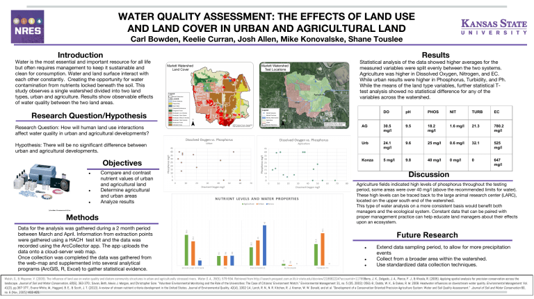
WATER QUALITY ASSESSMENT: THE EFFECTS OF LAND USE AND LAND COVER IN URBAN AND AGRICULTURAL LAND Carl Bowden, Keelie Curran, Josh Allen, Mike Konovalske, Shane Touslee Results Introduction Water is the most essential and important resource for all life but often requires management to keep it sustainable and clean for consumption. Water and land surface interact with each other constantly. Creating the opportunity for water contamination from nutrients locked beneath the soil. This study observes a single watershed divided into two land types, urban and agriculture. Results show observable effects of water quality between the two land areas. Statistical analysis of the data showed higher averages for the measured variables were split evenly between the two systems. Agriculture was higher in Dissolved Oxygen, Nitrogen, and EC. While urban results were higher in Phosphorus, Turbidity, and Ph. While the means of the land type variables, further statistical Ttest analysis showed no statistical difference for any of the variables across the watershed. Research Question/Hypothesis DO pH PHOS NIT TURB EC Research Question: How will human land use interactions affect water quality in urban and agricultural developments? AG 30.5 mg/l 9.5 18.2 mg/l 1.6 mg/l 21.3 780.2 mg/l Hypothesis: There will be no significant difference between urban and agricultural developments. Urb 24.1 mg/l 9.6 25 mg/l 0.6 mg/l 32.1 525 mg/l Konza 5 mg/l 9.8 40 mg/l 0 mg/l 0 647 mg/l Objectives ● ● ● Compare and contrast nutrient values of urban and agricultural land Determine agricultural and urban areas Analyze results Methods Data for the analysis was gathered during a 2 month period between March and April. Information from extraction points were gathered using a HACH test kit and the data was recorded using the ArcCollector app. The app uploads the data onto a cloud-server web map. Once collection was completed the data was gathered from the web-map and supplemented into several analytical programs (ArcGIS, R, Excel) to gather statistical evidence. Discussion Agriculture fields indicated high levels of phosphorus throughout the testing period, some areas were over 40 mg/l (above the recommended limits for water). These high levels can be traced back to the large animal research center (LARC), located on the upper south end of the watershed. This type of water analysis on a more consistent basis would benefit both managers and the ecological system. Constant data that can be paired with proper management practice can help educate land managers about their effects upon an ecosystem. Future Research ● ● ● Extend data sampling period, to allow for more precipitation events Collect from a broader area within the watershed. Use standardized data collection techniques. Walsh, G., & Wepener, V. (2009). The influence of land use on water quality and diatom community structures in urban and agriculturally stressed rivers. Water S. A., 35(5), 579-594. Retrieved from http://search.proquest.com.er.lib.k-state.edu/docview/218682224?accountid=11789Berry, J. K., Delgado, J. A., Pierce, F. J., & Khosla, R. (2005). Applying spatial analysis for precision conservation across the landscape. Journal of Soil and Water Conservation, 60(6), 363-370.; Savan, Beth, Alexis J. Morgan, and Christopher Gore. "Volunteer Environmental Monitoring and the Role of the Universities: The Case of Citizens' Environment Watch." Environmental Management 31, no. 5 (05, 2003): 0561-8.; Dodds, W. K., & Oakes, R. M. 2008. Headwater influences on downstream water quality. Environmental Management. Vol. 41(3), pp.367-377.; Evans-White, M., Haggard, B. E., & Scott, J. T. (2013). A review of stream nutrient criteria development in the United States. Journal of Environmental Quality, 42(4), 1002-14.; Lerch, R. N., N. R. Kitchen, R. J. Kremer, W. W. Donald, and et al. "Development of a Conservation-Oriented Precision Agriculture System: Water and Soil Quality Assessment." Journal of Soil and Water Conservation 60, no. 6 (Nov, 2005): 411-421.
