How Integrating MODIS Data Enhances Numerical Predictions of Sea Breezes
advertisement

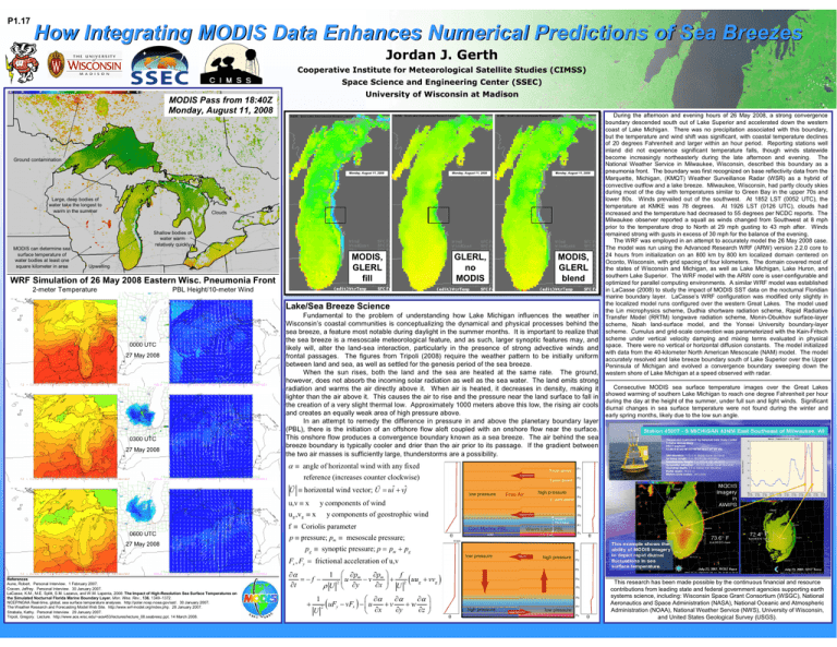
P1.17 How Integrating MODIS Data Enhances Numerical Predictions of Sea Breezes Jordan J. Gerth Cooperative Institute for Meteorological Satellite Studies (CIMSS) Space Science and Engineering Center (SSEC) University of Wisconsin at Madison MODIS Pass from 18:40Z Monday, August 11, 2008 GLERL: Great Lakes Environmental Research Laboratory GLERL: Great Lakes Environmental Research Laboratory GLERL: Great Lakes Environmental Research Laboratory Ground contamination Large, deep bodies of water take the longest to warm in the summer MODIS can determine sea surface temperature of water bodies at least one square kilometer in area Monday, August 11, 2008 Monday, August 11, 2008 Monday, August 11, 2008 MODIS, GLERL fill GLERL, no MODIS MODIS, GLERL blend Clouds Shallow bodies of water warm relatively quickly Upwelling WRF Simulation of 26 May 2008 Eastern Wisc. Wisc. Pneumonia Front 2-meter Temperature PBL Height/10-meter Wind Lake/Sea Breeze Science 0000 UTC 27 May 2008 0300 UTC 27 May 2008 Fundamental to the problem of understanding how Lake Michigan influences the weather in Wisconsin’s coastal communities is conceptualizing the dynamical and physical processes behind the sea breeze, a feature most notable during daylight in the summer months. It is important to realize that the sea breeze is a mesoscale meteorological feature, and as such, larger synoptic features may, and likely will, alter the land-sea interaction, particularly in the presence of strong advective winds and frontal passages. The figures from Tripoli (2008) require the weather pattern to be initially uniform between land and sea, as well as settled for the genesis period of the sea breeze. When the sun rises, both the land and the sea are heated at the same rate. The ground, however, does not absorb the incoming solar radiation as well as the sea water. The land emits strong radiation and warms the air directly above it. When air is heated, it decreases in density, making it lighter than the air above it. This causes the air to rise and the pressure near the land surface to fall in the creation of a very slight thermal low. Approximately 1000 meters above this low, the rising air cools and creates an equally weak area of high pressure above. In an attempt to remedy the difference in pressure in and above the planetary boundary layer (PBL), there is the initiation of an offshore flow aloft coupled with an onshore flow near the surface. This onshore flow produces a convergence boundary known as a sea breeze. The air behind the sea breeze boundary is typically cooler and drier than the air prior to its passage. If the gradient between the two air masses is sufficiently large, thunderstorms are a possibility. During the afternoon and evening hours of 26 May 2008, a strong convergence boundary descended south out of Lake Superior and accelerated down the western coast of Lake Michigan. There was no precipitation associated with this boundary, but the temperature and wind shift was significant, with coastal temperature declines of 20 degrees Fahrenheit and larger within an hour period. Reporting stations well inland did not experience significant temperature falls, though winds statewide become increasingly northeasterly during the late afternoon and evening. The National Weather Service in Milwaukee, Wisconsin, described this boundary as a pneumonia front. The boundary was first recognized on base reflectivity data from the Marquette, Michigan, (KMQT) Weather Surveillance Radar (WSR) as a hybrid of convective outflow and a lake breeze. Milwaukee, Wisconsin, had partly cloudy skies during most of the day with temperatures similar to Green Bay in the upper 70s and lower 80s. Winds prevailed out of the southwest. At 1852 LST (0052 UTC), the temperature at KMKE was 78 degrees. At 1926 LST (0126 UTC), clouds had increased and the temperature had decreased to 55 degrees per NCDC reports. The Milwaukee observer reported a squall as winds changed from Southwest at 8 mph prior to the temperature drop to North at 29 mph gusting to 43 mph after. Winds remained strong with gusts in excess of 30 mph for the balance of the evening. The WRF was employed in an attempt to accurately model the 26 May 2008 case. The model was run using the Advanced Research WRF (ARW) version 2.2.0 core to 24 hours from initialization on an 800 km by 800 km localized domain centered on Oconto, Wisconsin, with grid spacing of four kilometers. The domain covered most of the states of Wisconsin and Michigan, as well as Lake Michigan, Lake Huron, and southern Lake Superior. The WRF model with the ARW core is user-configurable and optimized for parallel computing environments. A similar WRF model was established in LaCasse (2008) to study the impact of MODIS SST data on the nocturnal Floridian marine boundary layer. LaCasse’s WRF configuration was modified only slightly in the localized model runs configured over the western Great Lakes. The model used the Lin microphysics scheme, Dudhia shortware radiation scheme, Rapid Radiative Transfer Model (RRTM) longwave radiation scheme, Monin-Obukhov surface-layer scheme, Noah land-surface model, and the Yonsei University boundary-layer scheme. Cumulus and grid-scale convection was parameterized with the Kain-Fritsch scheme under vertical velocity damping and mixing terms evaluated in physical space. There were no vertical or horizontal diffusion constants. The model initialized with data from the 40-kilometer North American Mesoscale (NAM) model. The model accurately resolved and lake breeze boundary south of Lake Superior over the Upper Peninsula of Michigan and evolved a convergence boundary sweeping down the western shore of Lake Michigan at a speed observed with radar. Consecutive MODIS sea surface temperature images over the Great Lakes showed warming of southern Lake Michigan to reach one degree Fahrenheit per hour during the day at the height of the summer, under full sun and light winds. Significant diurnal changes in sea surface temperature were not found during the winter and early spring months, likely due to the low sun angle. α ≡ angle of horizontal wind with any fixed reference (increases counter clockwise) r r U ≡ horizontal wind vector; U = uiˆ + vjˆ u,v ≡ x an y components of wind u g ,v g ≡ x an y components of geostrophic wind f ≡ Coriolis parameter 0600 UTC 27 May 2008 p ≡ pressure; pm ≡ mesoscale pressure; p g ≡ synoptic pressure; p = pm + pg Fx , Fy = frictional acceleration of u,v References Aune, Robert. Personal Interview. 1 February 2007. Craven, Jeffrey. Personal Interview. 30 January 2007. LaCasse, K.M., M.E. Splitt, S.M. Lazarus, and W.M. Lapenta, 2008: The Impact of High-Resolution Sea Surface Temperatures on the Simulated Nocturnal Florida Marine Boundary Layer. Mon. Wea. Rev., 136, 1349–1372. NCEP/NOAA Real-time, global, sea surface temperature analyses. http://polar.ncep.noaa.gov/sst/. 30 January 2007. The Weather Research and Forecasting Model Web Site. http://www.wrf-model.org/index.php. 28 January 2007. Strabala, Kathy. Personal Interview. 29 January 2007. Tripoli, Gregory. Lecture. http://www.aos.wisc.edu/~aos453/lectures/lecture_08.seabreez.ppt. 14 March 2008. ∂α 1 ∂pm ∂p u =−f − −v m 2 ∂t ∂x ρ U ∂y + 1 U 2 ( uF y f + 2 ( uu g + vvg ) U ∂α ∂α ∂α − vFx ) − u +v +w ∂y ∂z ∂x This research has been made possible by the continuous financial and resource contributions from leading state and federal government agencies supporting earth systems science, including: Wisconsin Space Grant Consortium (WSGC), National Aeronautics and Space Administration (NASA), National Oceanic and Atmospheric Administration (NOAA), National Weather Service (NWS), University of Wisconsin, and United States Geological Survey (USGS).


