NSW Vic. Qld SA
advertisement
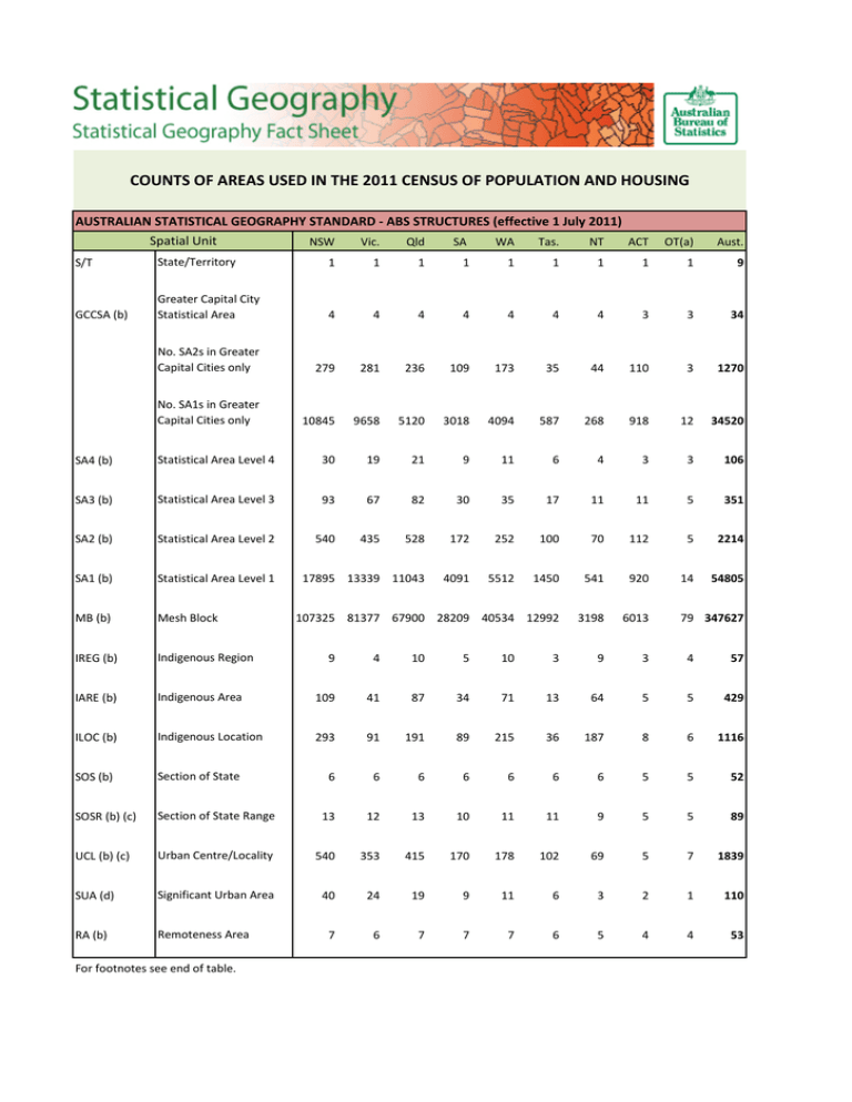
COUNTS OF AREAS USED IN THE 2011 CENSUS OF POPULATION AND HOUSING AUSTRALIAN STATISTICAL GEOGRAPHY STANDARD - ABS STRUCTURES (effective 1 July 2011) Spatial Unit NSW Vic. Qld SA WA Tas. NT ACT OT(a) Aust. S/T State/Territory 1 1 1 1 1 1 1 1 1 9 GCCSA (b) Greater Capital City Statistical Area 4 4 4 4 4 4 4 3 3 34 No. SA2s in Greater Capital Cities only 279 281 236 109 173 35 44 110 3 1270 No. SA1s in Greater Capital Cities only 10845 9658 5120 3018 4094 587 268 918 12 34520 SA4 (b) Statistical Area Level 4 30 19 21 9 11 6 4 3 3 106 SA3 (b) Statistical Area Level 3 93 67 82 30 35 17 11 11 5 351 SA2 (b) Statistical Area Level 2 540 435 528 172 252 100 70 112 5 2214 SA1 (b) Statistical Area Level 1 17895 13339 11043 4091 5512 1450 541 920 14 54805 MB (b) Mesh Block 107325 81377 67900 28209 40534 12992 3198 6013 IREG (b) Indigenous Region IARE (b) 79 347627 9 4 10 5 10 3 9 3 4 57 Indigenous Area 109 41 87 34 71 13 64 5 5 429 ILOC (b) Indigenous Location 293 91 191 89 215 36 187 8 6 1116 SOS (b) Section of State 6 6 6 6 6 6 6 5 5 52 SOSR (b) (c) Section of State Range 13 12 13 10 11 11 9 5 5 89 UCL (b) (c) Urban Centre/Locality 540 353 415 170 178 102 69 5 7 1839 SUA (d) Significant Urban Area 40 24 19 9 11 6 3 2 1 110 RA (b) Remoteness Area 7 6 7 7 7 6 5 4 4 53 For footnotes see end of table. AUSTRALIAN STATISTICAL GEOGRAPHY STANDARD - NON-ABS STRUCTURES (effective 1 July 2011) Spatial Unit LGA (e) Local Government Area POA (d) (f) (g) Postal Area NSW Vic. Qld SA WA Tas. NT ACT OT(a) Aust. 154 81 76 72 141 31 18 2 2 577 612 669 426 321 337 111 32 28 5 2516 2629 1547 1861 849 889 423 218 106 7 8529 SSC (b) (h) State Suburb CED (b) (i) Commonwealth Electoral Division 50 39 32 13 17 7 4 4 4 168 SED (b) (j) State Electoral Division 95 90 91 49 61 25 27 5 3 446 6 4 7 8 7 3 5 3 4 15 16 12 17 10 8 5 3 3 5 79 Australian Drainage ADD (d) (g) (k) Division NRMR (b) Natural Resource Management Region AUSTRALIAN STANDARD GEOGRAPHICAL CLASSIFICATION (effective 1 July 2011) Spatial Unit SLA (b) Statistical Local Area NSW Vic. Qld SA WA Tas. NT ACT OT(a) Aust. 201 211 477 129 156 45 68 116 5 1408 (a) Other Territories (OT) includes the Territories of Cocos (Keeling) Islands, Christmas Island and Jervis Bay. (b) Includes records for Migratory–Offshore–Shipping and No usual address for each State and Territory. (c) Includes records for Remainder of State/Territory. (d) May cross State and Territory borders and can be counted more than once in individual State and Territory figures but only once in the Australia total. (e) Includes records for LGA 9399 Unincorporated and LGA 9499 No usual address for each State and Territory. (f) Migratory–Offshore–Shipping (Aust.), No usual address (Aust.) included in the counts for each State and Territory. Unclassified (Aust.) included in the count for Tas. only. (g) The Australia total count includes one record each for Migratory–Offshore–Shipping (Aust.), No usual address (Aust.) and Unclassified (Aust.). (h) Includes records for Unclassified in NSW, Vic., SA, Tas. and ACT. (i) The ACT Electoral Division of Fraser includes Jervis Bay and is counted in ACT and OT. The NT Electoral Division of Lingiari includes Christmas Island and Cocos (Keeling) Islands and is counted in NT and OT. Each is counted only once in the Australia total. (j) Includes record for Unclassified in OT. (k) Migratory–Offshore–Shipping (Aust.), No usual address (Aust.) included in the counts for each State and Territory. Unclassified (Aust.) included in the count for OT only. Note: Records for Migratory–Offshore–Shipping, No usual address, Unclassified and Unincorporated do not have spatial objects in the digital boundary files, therefore these records are not mappable in Geographic Information Systems (GIS).
