" £ ¬ )
advertisement

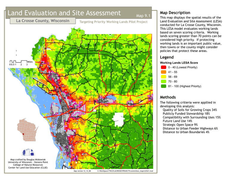
Land Evaluation and Site Assessment La Crosse County, Wisconsin Map 9.1 Targeting Priority Working Lands Pilot Project " ) " ) A Q " ) T : 0 0.5 1 2 M £ ¤ " ) 93 Miles 3 " ) TT ¬ « DD " ) 35 " ) " ) " ) " ) TA T " ) T W D " ) " ) AE " ) " ) V " ) VV EE ¬ « 108 " ) WW ¬ « 162 41 - 55 E DE " ) " ) " ) " ) " ) SN 70 - 80 81 - 100 (Highest Priority) " ) S " ) M OT ZB 56 - 69 " ) " ) ZN 0 - 40 (Lowest Priority) C " ) " ) Legend " ) XX ZZ Methods ¬ « 16 Z " ) " ) ¬ « U 16 " ¬ «) " ) 157 B § ¦ ¨ OS 90 PH " ) B ¬ « " ) 16 O " ) " ) ¬ « J 162 " ) II " ) JJ " ) OA FA " ) " ) " ) " ) ¬ « " ) YY F JB I FO 33 ¬ « " ) 33 M " ) G Map crafted by Douglas Miskowiak University of Wisconsin - Stevens Point College of Natural Resources Center for Land Use Education (CLUE) " ) GI ¬ « 35 This map displays the spatial results of the Land Evaluation and Site Assessment (LESA) conducted for La Crosse County, Wisconsin. This LESA model evaluates working lands based on seven scoring criteria. Working lands scoring greater than 70 points can be considered high priority. If protecting working lands is an important public value, then towns or the county might consider policies that protect these areas. Working Lands LESA Score " ) HD MH Map Description " ) MM " ) " ) NN N Map version 12_14_08 " ) PI " ) H " ) X C:\WorkSpace\TWLO\LACROSSE\PROJECTS\committee_maps\LESA1.mxd The following critieria were appllied in developing this analysis: Quality of Soils for Growing Crops 34% Publicly Funded Stewardship 18% Compatibility with Surrounding Uses 15% Future Land Use 14% Strategic Open Space 9% Distance to Urban Feeder Highways 6% Distance to Urban Boundaries 4%


