The Development of a Direct Georeferencing Ready UAV based photogrammetry...
advertisement

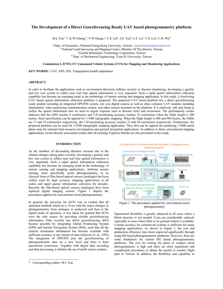
The Development of a Direct Georeferencing Ready UAV based photogrammetry platform M.L.Tsai a *, K.W.Chiang a, Y.W.Huang a, Y.S. Linb, J.S. Tsaib, C.F. Loc, Y.S. Linc, C.H. Wud a Dept. of Geomatics, National Cheng Kung University, Taiwan - taurus.bryant@msa.hinet.net b National Land Surveying and Mapping Center, Ministry Of The Interior, Taiwan c GeoSat Informatics Technology Corporation, Taiwan d Dept. of Mechanical Engineering, Yuan Ze University, Taiwan Commission I, ICWG I/V Unmanned Vehicle Systems (UVS) for Mapping and Monitoring Applications KEY WORDS: UAV, GPS, INS, Triangulation bundle adjustment ABSTRACT: In order to facilitate the applications such as environment detection, military security or disaster monitoring, developing a quickly and low cost system to collect near real time spatial information is very important. Such a rapid spatial information collection capability has become an emerging trend in the technology of remote sensing and mapping application. In this study, a fixed-wing UAV based spatial information collection platform is proposed. The proposed UAV based platform has a direct georeferencing ready module including an integrated GPS/INS system, low cost digital camera as well as other common UAV modules including immediately video monitoring communication system, and other sensors mounted on the platform. It is relatively safe and cheap to collect the spatial information that we need to urgent response such as disaster relief and assessment. The preliminarily results indicates that the GSD reaches 6 centimeters and 3-D positioning accuracy reaches 10 centimeters when the flight height is 300 meters. Such specification can be applied for 1/1000 topographic mapping. When the flight height is 600 and 900 meters, the GSDs are 17 and 19 centimeters respectively, the 3-D positioning accuracy reaches 23 and 50 centimeters respectively. Furthermore, the proposed platform can be used for 1/2500 topographic mapping application. They also can be applied for producing 1/5000 aerial photo map for national land resources investigation and general navigation applications. In addition to those conventional mapping applications, recent disaster assessment results after devastating Typhoon Morakt are also presented in this study. As the numbers of devastating disasters increase due to the climate changes taking place recently, developing a quickly and low cost system to collect near real time spatial information is very important. Such a rapid spatial information collection capability has become an emerging trend in the technology of remote sensing and mapping applications. Airborne remote sensing, more specifically aerial photogrammetry, in its classical form of film-based optical sensors (analogue) has been widely used for high accuracy mapping applications at all scales and rapid spatial information collection for decades. Recently the film-based optical sensors (analogue) have been replaced digital imaging sensors. Figure 1 depicts the procedures applied for conventional aerial photogrammetry. In general, the necessity for GCPs was so evident that all operation methods relied on it. Even with the major changes in photogrammetry from analogue to analytical and then to the digital mode of operation, it was taken for granted that GCPs were the only source for providing reliable georeferencing information. Only recently has direct georeferencing (DG) become possible by integrating Global Positioning System (GPS) and Inertial Navigation System (INS), such that all the exterior orientation information has become available with sufficient accuracy at any instant of time (Schwarz et. al., 1993). The integration of GPS/INS puts the georeferencing of photogrammetric data on a new level and frees it from operational restrictions. Together with digital data recording and data processing, it initiates the era of multi-sensor systems. * Corresponding author: M.L.Tsai. The Flow Charts of Conventional and DG based photogrammetric mapping scenarios Conventional photogrammetry Flight path Planning GCP Surveying Spatial data collection Film/image processing ¦ a ¦ i e ¦ S c le e c cost INTRODUCTION Stereo plotting AT Editing and finishing DG based photogrammetry Flight path Planning Spatial data collection Mapping, editing , finishing Production Production ¦ D a te ¦ T im e ¦ S c a le e tc . Figure 1. The procedures applied for conventional aerial photogrammetry Operational flexibility is greatly enhanced in all cases where a block structure is not needed. Costs are considerably reduced, especially in areas where little or no ground control is available. Current accuracy for commercial systems is sufficient for many mapping applications. As shown in Figure 1, the cost and production efficiency have been improved significantly through using DG based photogrammetric platforms. However, there are some limitations for current DG based photogrammetric platforms. The cost for renting the plane to conduct aerial photogrammetry is high and there are strict regulations and complicated procedures to obtain the permit to conduct flight plan in Taiwan. In addition, the flexibility and capability to conduct small area survey or rapid spatial information collection is rather limited. Therefore, a DG ready airborne platform that is relatively free of government regulations as well as costs less flight expanse but maintains high mobility for small area survey or rapid spatial information collection is desired for urgent response such as disaster relief and assessment. THE TECHNUCAL CONFIGURATIONS OF PROPOSED PLATFORM 12V Battery UAV 3V +-12V Camera DG Module Flight control PC Flight data 5Hz GPS Reviver Navigation data GPS/IMU Phase data AEK-4T AntiLog Time mark AEK‐4T Power switch Battery Wireless Communication △Vs, △θs MMQ 5V MMQ‐G Pla tform Flight control Power switch circuit The configuration of proposed DG ready UAV photogrammetric platform is illustrated in Figure 2. The specifications of proposed UAV platform including its interior design are illustrated in Figure 3. As indicated in the figure, the proposed UAV is designed for medium range applications. The maximum operational range is 20 km and its real time video transmission range is km with extended range communication links. The flexible flight altitude and two hours endurance time make it a suitable to small area and large scale photogrammetric mission. Figure 4 depicts the DG module designed in this study to facilitate GCP free photogrammetry as well as INS/GPS POS aided bundle adjustment. The data storage module used to record the measurements collected by IMU(MMQ-G), GPS(AEK-4T) as well as synchronized time mark used to trigger Camera(Canon 450D) is Antilog from Martelec. Due to the limitations of payload and power supply, a PC or notebook based data storage module is ruled out. Therefore, a simple mechanization that can store measurements communicated though serial ports is desired. Therefore, Antilog is chosen because of its unrivalled flexibility, low power consumption, and reliability. Similarly, since EOS 450D has its own storage mechanization, it is not included in this module. Digital camera POS data Event trigger Data storage module Figure 2. The configuration of proposed DG ready UAV photogrammetric platform Data logger Figure 4. The configuration of DG module Figure 5 illustrates the set up of the DG module within the UAV platform. As shown in this figure, the MMQ-G is set right on top of the camera. The nominal location of GPS antenna is in the B compartment. MMQ‐G Canon EOS 450D Power switch Antilog AEK‐4T Figure 5. The set up of DG module in UAV THE DATA PROCESSING STRETEGY Figure 3. The specifications of proposed UAV platform Figures 6 and 7 illustrates the INS/GPS POS assisted AT based photogrammetric process and DG based photogrammetric process implemented in this study, respectively. GCP Digital images IOP Tie points measurements Calibration GCP measurements INS/GPS POS Bundle adjustment Boresight lever arm DSM/DEM Mosaic/final Orthophoto product Figure 6. The proposed INS/GPS POS assisted AT based photogrammetric process Digital images IOP Tie points measurements Digital images Calibration INS/GPS POS DG Mosaic/final product Boresight lever arm DSM/DEM Rapid spatial information Orthophoto Disaster relief & assessment Figure 8. The loosely coupled INS/GPS integrated scheme RESULTS AND DISCUSSIONS To validate the performance of proposed platform, a field test was conducted in the winter, 2009. The area of the test zone is 3km*3km, which is covered by the red square shown in Figure 9. The blue region illustrated the fly zone approved for this test. This region is chosen because it is composed complicated landscapes including a township, farms, traffic networks and rivers. Most important of all, this area is covered with intensively distributed GCPS that can be applied for bundle adjustment process as well as the checking points used for performance validation. Figure 7. The proposed DG-ready photogrammetric procedure Post-mission processing, when compared to real-time filtering, has the advantage of having the data of the whole mission to estimate the trajectory (Shin and El-Sheimy, 2005). This is not possible when using filtering because only part of the data is available at each trajectory point, except the last. When filtering is used in the first step, an optimal smoothing method, such as Rauch-Tung-Striebel (RTS) backward smoother, can be applied (Chiang et. al., 2004). It uses the filtered results and their covariances as a first approximation. This approximation is improved by using additional data that was not used in the filtering process. Depending on the type of data used, the improvement obtained by optimal smoothing can be considerable (Gelb, 1974). Figure 9. The proposed DG-ready photogrammetric procedure For georeferencing process which puts POS stamps on images and measurement process that obtains 3-D coordinates of all important features and stores them in GIS database, only postmission processing can be implemented based on the complexity of those processes (El-Sheimy, 2002). Therefore, most of the commercially available DG systems operate in real time only for data acquisition and conduct most of the data processing and analysis in post-mission mode. Figure 8 illustrates the loosely coupled INS/GPS integrated scheme implemented in this study. Flight planning The flight altitudes set for aerial photography is 1200 meters, 900 meters, 600 meters and 300 meters above ground, respectively. Because the limit of the payload and the impact of side wind affecting the attitude of UAV, the Endlap and Sidelap were increased to 80% and 40% respectively to insure that the coverage of the stereo pair can overlap completely during the test flight. Although more images have to be processed, it can be guarantee that the completed coverage of the stereo pair. INS/GPS POS results Figure 10 illustrates the trajectory of INS/GPS integrated POS solutions. Due to the lack of anti-vibration design, high frequency vibration of the UAV platform fail the Antilog to log high sampling rate IMU raw measurements, on the contrary, the GPS raw measurements with 1 Hz sampling rate were recorded normally and were processed with carrier phase measurements in differential mode. The DGPS trajectory is shown in red while that of INS/GPS integrated POS processed with EKF and RTS smoother are shown in yellow and blue, respectively. Although interpolation was implemented to fill the gaps, the gaps were too long and too many to be bridged. Therefore, frequent IMU data losses cause the irregular peaks shown in the figure. Figures 11 and 12 illustrate the time spans of when Antilog dallied to log IMU raw measurements. This issue has been taken care of through proper anti-vibration deign and another field test will be arranged around spring 2010. Consequently, due to this unexpected twist, INS/GPS integrated POS solutions were applied to assist bundle adjustment only when the IMU raw measurements exist, otherwise, GPS solutions were applied instead. Figure 12. The loss accelerometers data Photogrammetric results analysis The area of the test zone set for the scenarios with 1200 meters, 900 meters and 600 meters altitude is 3km*3km and that for the scenario with 300 meters altitude is 800m*600m. The preliminarily results indicate that the GSD reaches 6 centimeters and 3-D positioning accuracy reaches 10 centimeters when the flight height is 300 meters. Such specification can be applied for 1/1000 topographic mapping. When the flight heights increase to 600 and 900 meters, the GSDs are 17 and 19 centimeters respectively, the 3-D positioning accuracies reaches 23 and 50 centimeters respectively. Furthermore, the proposed platform can be used for 1/2500 topographic mapping application. In addition, they can be applied for producing 1/5000 aerial photo map for national land resources investigation and general navigation applications. In addition, Table 1 depicts the numerical performance of those orthophotos with respect to check points from different scenarios. Table 1. The accuracy of orthophotos from different scenarios Item Figure 10. the trajectory of INS/GPS integrated POS X(m) Y(m) XY(m) 1200m 0.39 0.32 0.51 900m 0.39 0.35 0.52 600m 0.35 0.32 0.47 The performance verification process indicates the proposed platform can capture the aerial images successfully fulfilling the requirements of different tasks. With the proposed low cost but high mobility direct georeferencing ready UAV based platform, the efficiency and expanse of certain photogrammetry can be significant improved without sacrificing too much positioning accuracy. In addition, the direct georeferencing ready function of proposed platform guarantee the mapping and positioning capability even in GCP-free environments, which is very important for rapid urgent response for disaster relief. CONCLUSIONS Figure 11. The loss gyroscopes and accelerometers data The performance verification process indicates the proposed platform can capture the aerial images successfully fulfilling the requirements of different tasks. With the proposed low cost but high mobility direct georeferencing ready UAV based platform, the efficiency and expanse of certain photogrammetry can be significant improved without sacrificing too much positioning accuracy. In addition, the direct georeferencing ready function of proposed platform guarantee the mapping and positioning capability even in GCP-free environments, which is very important for rapid urgent response for disaster relief. Therefore, the future works of this study is to implement a direct georeferencing based UAV disaster relief platform that can perform a large scale and small area rapid map production in disaster area with the support of direct georeferencing based rescue missions. REFERENCES Chiang, K.W., Noureldin, A. and El-Sheimy, N., 2004. A New Weight Updating Method for INS/GPS Integration Architectures Based on Neural Networks. Measurement Science and Technology, 15 (10), pp. 2053-2061. Gelb, A., 1974. Applied Optimal Estimation. The Analytic Science Corporation. El-Sheimy, N., 2002. Introduction to Inertial Navigation. Geomatics Department, University of Calgary, ENGO 699.71 lecture notes. Schwarz, K.P., Chapman, M.E., Cannon, E., and Gong, P., 1993. An Integrated INS/GPS approach to the georeferencing of remotely sensed data. Photogrammetric Engineering & Remote Sensing, 59 (11), pp. 1667-1674. Shin, E.H. and El-Sheimy, N., 2005. Navigation Filter Design for Pipeline Pigging. Journal of Navigation, Cambridge University Press, 58, pp. 283-295. ACKNOWLEDGMENTS The author would acknowledge the financial support by the National Land Surveying and Mapping Center, Ministry Of The Interior, ROC (Taiwan) (NLSC-97-28). From his supervisor, Dr. Kai-Wei Chiang, who initially encouraged him to apply and by given him the time and resources needed for helping him accomplishing this work. Dr. Cheng-Feng Lo and his colleagues from GeoSat Informatics Technology Co and Dr. Chung-Hui Wu from Skyline Dynamics Co. are acknowledged for the development of UAV platform as well as their assistance conducting the test flight.


