Sagebrush Restoration in the Shrub-Steppe of South-Central Washington J. J. J.
advertisement
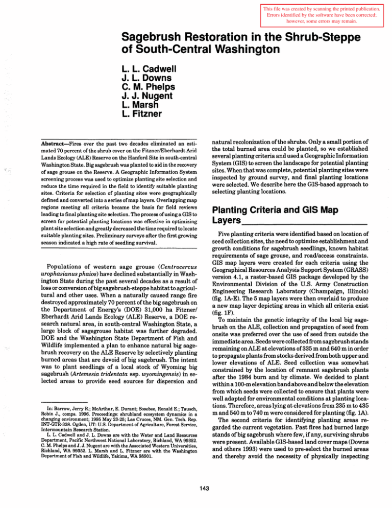
This file was created by scanning the printed publication. Errors identified by the software have been corrected; however, some errors may remain. Sagebrush Restoration in the Shrub-Steppe of South-Central Washington L. L. Cadwell J. L. Downs C. M. Phelps J. J. Nugent L. Marsh L. Fitzner natural recolonization of the shrubs. Only a small portion of the total burned area could be planted, so we established several planting criteria and used a Geographic Information System (GIS) to screen the landscape for potential planting sites. When that was complete, potential planting sites were inspected by ground survey, and final planting locations were selected. We describe here the GIS-based approach to selecting planting locations. Abstract-Fires over the past two decades eliminated an estimated 70 percent of the shrub cover on the FitznerlEberhardt Arid Lands Ecology (ALE) Reserve on the Hanford Site in south-central Washington State. Big sagebrush was planted to aid in the recovery of sage grouse on the Reserve. A Geographic Information System screening process was used to optimize planting site selection and reduce the time required in the field to identify suitable planting sites. Criteria for selection of planting sites were geographically defined and converted into a series of map layers. Overlapping map regions meeting all criteria became the basis for field reviews leading to final planting site selection. The process of using a GIS to screen for potential planting locations was effective in optimizing plant site selection and greatly decreased the time required to locate suitable planting sites. Preliminary surveys after the first growing season indicated a high rate of seedling survival. Planting Criteria and GIS Map Layers ______________________ Five planting criteria were identified based on location of seed collection sites, the need to optimize establishment and growth conditions for sagebrush seedlings, known habitat requirements of sage grouse, and road/access constraints. GIS map layers were created for each criteria using the Geographical Resources Analysis Support System (GRASS) version 4.1, a raster-based GIS package developed by the Environmental Division of the u.s. Army Construction Engineering Research Laboratory (Champaign, Illinois) (fig. lA-E). The 5 map layers were then overlaid to produce a new map layer depicting areas in which all criteria exist (fig. 1F). To maintain the genetic integrity of the local big sagebrush on the ALE, collection and propagation of seed from onsite was preferred over the use of seed from outside the immediate area. Seeds were collected from sagebrush stands remaining on ALE at elevations of 335 m and 640 m in order to propagate plants from stocks derived from both upper and lower elevations of ALE. Seed collection was somewhat constrained by the location of remnant sagebrush plants after the 1984 burn and by climate. We decided to plant within a 100-m elevation band above and below the elevation from which seeds were collected to ensure that plants were well adapted for environmental conditions at planting locations. Therefore, areas lying at elevations from 235 m to 435 m and 540 m to 740 m were considered for planting (fig. 1A). The second criteria for identifying planting areas regarded the current vegetation. Past fires had burned large stands of big sagebrush where few, if any, surviving shrubs were present. Available GIS-based land cover maps (Downs and others 1993) were used to pre-select the burned areas and thereby avoid the necessity of physically inspecting Populations of western sage grouse (Centrocercus urophasianus phaios) have declined substantially in Washington State during the past several decades as a result of loss or conversion ofbig sagebrush-steppe habitat to agricultural and other uses. When a naturally caused range fire destroyed approximately 70 percent of the big sagebrush on the Department of Energy's (DOE) 31,000 ha Fitzner/ Eberhardt Arid Lands Ecology (ALE) Reserve, a DOE research natural area, in south-central Washington State, a large block of sagegrouse habitat was further degraded. DOE and the Washington State Department of Fish and Wildlife implemented a plan to enhance natural big sagebrush recovery on the ALE Reserve by selectively planting burned areas that are devoid of big sagebrush. The intent was to plant seedlings of a local stock of Wyoming big sagebrush (Artemesia tridentata ssp. wyomingensis) in selected areas to provide seed sources for dispersion and I?: Barrow, Jerry R; McArthur, E. Durant; Sosebee, Ronald E.; Tausch, Robm.J., co~ps. 1996. Proceedings: shrubland ecosystem dynamics in a changtng enVIronment; 1995 May 23-25; Las Cruces, NM. Gen. Tech. Rep. INT-GTR-338. Ogden, UT: U.S. Department of Agriculture Forest Service Intermountain Research Station. " L. L. Cadwell and J. L. Downs are with the Water and Land Resources Department, Pacific Northwest National Laboratory, Richland, WA 99352. C: M. Phelps and J. J. Nugent are with the Associated Western Universities, RIchland, WA 99352. L. Marsh and L. Fitzner are with the Washington Department ofFish and Wildlife, Yakima, WA 98901. 143 1iI- 235 to 435 m 1iI- 540 to 740 m A 0- Burned areas devoid of sagebrush B :,.: 111- Slopes less than 10° c 1iJ- 100 m buffer around draws D • - Existing sagebrush fiiI- Potential upper elevation sites 11- Potential lower elevation sites 1iJ- 500 m buffer around roads • - Restoration sites E F Figure 1-Map layers used in GIS analysis: (A) planting elevations; (8) burned areas; (C) slopes less than 10°; (0) 100 m buffer around draws; (E) 500 m buffer around roads; and (F) potential planting sites and actual selected planting locations. 144 o 5 Kilometers 10 large land areas to detennine whether or not specific areas were devoid of big sagebrush. The total area considered for restoration of sagebrush habitat was 24,600 ha comprising the land areas burned by wildfires in 1981 and 1984 (fig. IB). Research on sage grouse inhabiting sagebrush habitat adjacent to ALE indicate that grouse prefer gently sloping hillsides (Cadwell and others 1994). Therefore, planting locations were constrained to areas having slopes <10° to maximize the potential benefit of increased habitat for sage grouse. Areas of the reserve where slopes were less than 10 ° are shown in figure 1C. We further reasoned that seedling survival would likely be greatest in locations having the most available soil moisture. Thus, we decided to plant in or near draws where soil moisture may be most abundant, and established an additional planting criteria to limit planting sites to within 100 m of draws. Figure ID indicates a 100-m buffer around the numerous draws and drainages across the northeast facing slopes on ALE where soil moisture conditions might be more conducive to sagebrush seedling establishment and survival. The final planting criterion, one based not on biological constraints, but rather on cost and efficiency, was to restrict the planting operation to areas relatively near roads. Offroad driving is not allowed in the research natural area, and it was necessary to identify potential planting sites that could be conveniently accessed without hand-carrying planting tools and seedlings long distances. A 500-m buffer was developed for roadways on the reserve to indicate those areas where walking and carrying equipment and plants was most feasible (fig. IE). The common overlay area of the five map layers defined potential planting areas that met planting site selection criteria and consisted of approximately 2,990 ha (fig. IF). • Plant community dominated by native forbs and grasses rather than invasive alien species • Planting site large enough to plant 500 to 1,500 shrubs spaced several meters apart At each planting site, a global positioning system was used to detennine site coordinates for mapping, and the site was marked for location by planting crews. Planting was completed in March and April 1995. Conclusions _ _ _ _ _ _ _ _ __ The GIS-based approach to site selection proved to be both an effective and an efficient means to identify potential planting sites. Field surveys of the pre-selected sites confinned that the screening criteria for site selection were adequately identified by the map-based screening process. Time spent in the field marking plots for the planting crews was minimized because preselected locations were usually judged suitable for planting, and there was no need to spend field time searching for locations that met the basic screening criteria. In a few locations, existing vegetation cover that consisted of alien weedy species or soils that were excessively stony caused the preselected sites to be disqualified during the ground survey process. We have not yet completed surveys to detennine survival of the planted seedling, but preliminary late winter counts suggest that survival through the first growing season was greater than 85 percent. Although we did not set out to "study" the relative efficiency of GIS-based screening for big sagebrush planting site selection, it is clear that the application of GIS-based analyses simplified the process, facilitated selection of planting sites that met several basic "geographic" criteria, and saved a considerable amount oftime and money that would otherwise have been required to conduct field reconnaissance of potential planting locations. Final Sites and Planting References ------------------------------- The GIS analysis allows identification of potential planting zones, but visual reconnaissance of individual areas is required to confirm and "ground truth" the map infonnation in the GIS. Field surveys of the potential planting zones were conducted to verify the suitability of the area. A planting site was detennined suitable according to whether the site exhibited the following characteristics: Cadwell, Larry L.; Simmons, Mary Ann; Downs, Janelle L.; Sveum, Colin M. 1994. Sage grouse on the Yakima Trainig Center: a summary of studies conducted during 1991 and 1992. PNL-9464. Richland, WA Pacific Northwest Laboratory. 36 p. Downs, Janelle L.; Rickard, William H.; Brandt, Charles A; Cadwell, Larry L.; Cushing, Colbert E.; Geist, David R.; Mazaika, Rosmary M.; Neitzel, Duane A; Rogers, Lee E.; Sackschewsky, Michael R.; Nugent, John J. 1993. Habitat types on the Hanford Site: wildlife and plant species of concern. PNL-8942. Richland, WA Pacific Northwest Laboratory. 57 p. • Soils deeper than 1 m with relatively few rocks on the surface • Slope criteria «10°) were met 145
