DIGITAL AERIAL TRIANGULATION for DTM and ORTHOPHOTO GENERATION
advertisement
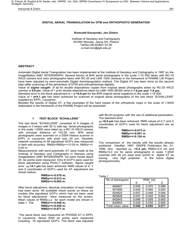
D. Fritsch, M. Englich & M. Sester, eds, 'IAPRS', Vol. 32/4, ISPRS Commission IV Symposium on GIS - Between Visions and Applications, Stuttgart, Germany. Kaczynski & Ziobro 281 DIGITAL AERIAL TRIANGULATION for DTM and ORTHOPHOTO GENERATION Romuald Kaczynski, Jan Ziobro Institute of Geodesy and Cartography 00-950 Warsaw, Jasna 2/4, Poland Tel/fax:(48-22)827 03 28 e-mail:rom@igik.edu.pl ABSTRACT Automatic Digital Aerial Triangulation has been implemented at the Institute of Geodesy and Cartography in 1997 on the ImageStation 6487 INTERGRAPH. Several blocks of B/W aerial photographs in the scale 1:15 000 taken with RC-10 WILD camera and color photographs taken with RC-20 and LMK 1000 cameras in the framework of PHARE LIS Project have been adjusted by semi-automatic Digital Aerotriangulation method. The Digital AT has been done as the second step (after scanning) of the generation of DTM and orthophotomap digitally. Value of sigma naught (• o) for double diapositives copied from original aerial photographs taken by RC-20 WILD camera is 8.9 µm. Value of • o for double diapositives taken by LMK-1000 ZEISS Jena is 7.6 µm and 7.9 µm. Standard error in the block adjustment is • o =6.8 µm for the B/W original aerial negatives in the scale 1:15 000. Value of • o=4.1 µm has been achieved for scanned of original aerial photographs of the test block “ECHALLENS” supplied by EPFL, Lausanne. Besides the results of Digital AT, a few examples of the hard copies of the orthophoto maps in the scale of 1:5000 elaborated in the framework of the PHARE Project will be presented 1 TEST BLOCK “ECHALLENS” The test block “ECHALLENS” consisted of 9 images (3 images in 3 strips) with 35 % side lap. Aerial photographs in the scale 1:5500 were taken by a RC-10 WILD camera with principal distance of 153.20 mm. B/W aerial photographs were scanned on a DSW Helava scanner in EPFL in Lauzanne with pixel size 20 µm. Geodetic network consisting of 48 signalized GCP’s was measured in field with accuracy RMSx=RMSy=+/-0.03 m, RMSz=+/0.05 m. Measurements with semi-automatic AT were made at the Institute of Geodesy and Cartography in Warsaw using ImageStation 6487 INTERGRAPH. On each model about 20 tie points were measured. Only 8 GCP’s were used for block adjustment using Photo-T software. Sigma naught error 80 =4.1 µm has been achieved. RMS values of X, Y and Z coordinates of GCP’s used for AT adjustment are shown bellow: RMSx=+/-0.019 m; RMSy=+/-0.013 m; RMSz=+/-0.005 m. After block adjustment, absolute orientation of each model had been done. All available check points on these six models (the signalized GCP’s which had not been used for block adjustment) were measured on the screen. Mean values of RMSx,y,z for each model are shown in table 1. The RMSx=+/-0.046 m, RMSy=+/-0.050 m, RMSz=+/-0.071 m. The same block was measured on PHODIS AT in EPFL in Lausanne. About 2000 tie points were measured including 18 signalized GCP’s. The block was adjusted with BLUH program with the use of additional parameters. The standard error 80 =6.8 µm has been achieved. RMS values of X,Y and Z coordinates of GCP’s used for block adjustment are as follows: RMSx=+/-0.073 m RMSy=+/-0.051 m RMSz=+/-0.124 m. The comparison of the results with the results already published (Hartfiel, 1997; OEEPE Publication No. 31, 1996, who reported 80 =5.4 µm, RMSx=2.0 cm and RMSy=4.0 cm for aerial photographs in scale 1:3500 scanned with 28 µm pixel size) points to digital AT as having very high potential in the future digital photogrammetry. Table 1 No of stereogram 806807 807808 824825 825826 842843 843844 Total mean value X 0.059 0.045 0.057 0.037 0.049 0.029 0.046 RMS [m] Y 0.070 0.060 0.048 0.032 0.055 0.035 0.050 Z 0.089 0.053 0.094 0.062 0.063 0.062 0.071 D. Fritsch, M. Englich & M. Sester, eds, 'IAPRS', Vol. 32/4, ISPRS Commission IV Symposium on GIS - Between Visions and Applications, Stuttgart, Germany. 282 2 IAPRS, Vol. 32, Part 4 "GIS-Between Visions and Applications", Stuttgart, 1998 PRODUCTION OF AERIAL TRIANGULATION BLOCKS IN IGIK Several blocks of aerial photographs taken with different cameras have been elaborated in IGiK mostly for DEM and orthophoto generation on ImageStation 6487 and PRI²SM/VI²STA of DATRON. Some of the results are shown in table 2. Color aerial photographs in the scale 1:26000 with end lap 60% and side lap 30% were taken in the framework of the PHARE LIS Project. Natural GCP’s were measured in field by GPS method with accuracy depending mostly on identification of the photopoins. Double color diapositives have been scanned in IGiK on a PhotoScan PS 1 Zeiss/INTERGRAPH scanner with 30 µm pixel size. Scanning was done with photoalignment and compression by JPEG Q=25. Semi automatic AT was done on Red band with Photo –T INTERGRAPH software. Automatic selection of tie points No. of strips No. of photos Camera ck [mm] Photo scale Pixel size [2m] Compression JPEG Orthophoto scale Output pixel size [m] No. of GCP’s A’priori RMS X [m] RMS Y [m] RMS Z [m] No. of tie points per model Matching accuracy in pixel 8o [2m] After AT adjustment RMS X [m] RMS Y [m] RMS Z [m] 3 and final measurements were done using hierarchical multi – image least square matching with accuracy 0.12 pixel (which is equal 3.6 µm in photo scale). Black- and- White aerial photography of a part of Warsaw was taken with RC-10 camera with end lap 60% and side lap 40 % in 1:15000 scale. GCP’s were taken from old topomaps in scale 1:1000. Scanning was made on a PhotoScan PS 1 with 30 µm pixel size, photoalignment and compression by JPEG Q=25. Automatic selection of 18 tie points on each model and final measurement were done using also multi-image least square matching method with accuracy 0.12 pixel. The achieved accuracy of the three blocks 80 < 8 µm (using double diapositives) was sufficient for DEM and ortophoto production in 1:10000 and 1:5000. It has been empirically proven that 18 tie points are recommended as optimum number to be used for each model. This guarantees the elimination of blunder errors with least effort. Block 1 4 32 RC 20 152 1: 26 000 30 Yes 1: 10 000 1.0 17 Block 2 4 26 LMK 1000 152 1 :26 000 30 Yes 1: 10 000 1.0 17 Block 3 3 22 RC 10 213 1:15 000 30 yes 1: 5 000 0.5 8 Table 2 Block 4 8 60 LMK 1000 152 1: 26 000 22.5 yes 1 : 5000 0.5 26 0.30 0.30 0.20 0.75 0.75 1.10 0.60 0.60 0.40 0.40 0.40 0.40 14 10 18 18 0.12 8.9 0.12 7.9 0.12 6.8 0.12 7.6 0.26 0.31 0.14 0.69 0.74 1.80 0.60 0.52 0.37 0.34 0.41 0.53 DEM AND ORHOPHOTO GENERATION USING RESULTS OF DIGITAL AERIAL TRIANGULATION The results of digital AT of color aerial photographs taken in the scale 1:26000 in the framework of PHARE LIS Project are mostly used in IGiK for DEM generation and orthophoto map generation in scale 1:5000 and 1:10000. Unfortunately, not original but double diapositives are scanned in 30 µm pixel size for orthophoto generation in the scale 1:10000. DEM with grid 25 m is generated automatically using MATCH-T INPHO software with optimum parameters. Generated DEM is edited stereoscopically. Color digital orthophoto maps in the scale: 1:5000 are generated from color aerial photograph taken in the scale 1:26 000 and scanned with 22.5 µm pixel size. Orthophoto in scale 1:10000 is generated with 1 meter output pixel size and orthophoto in scale 1:5000 with 0.5 m pixel size. Planimetric accuracy of these orthophotos are less then 1.5 pixel. Hardcopies of orthopohotmaps are printed in IGiK on high resolution ink-jet plotter IRIS 3047. Softcopy products are usually recorded as one map sheet on CD-ROM in TIFF format. These digital data are used by different users. D. Fritsch, M. Englich & M. Sester, eds, 'IAPRS', Vol. 32/4, ISPRS Commission IV Symposium on GIS - Between Visions and Applications, Stuttgart, Germany. Kaczynski & Ziobro 283 Acknowledgements The authors wish to express their thanks to Prof. Otto Kölbl for his support and providing the data and results of calculations for block “ECHALLENS”. Hartfiel P., 1997. Higher Performance with Automated Aerial Triangulation. Photogrammetric Week’97, Wichmann Verlag, pp.109-113. Experimental Test on Digital Triangulation. OEEPE Official Publication No.31, March 1996. Report by J.Jaakola and T.Sarjakoski. References Ackermann F., Schneider W., 1986. High Precision Aerial Triangulation with Point Transfer by Digital Image Correlation. Int. Archive of ISPRS, Vol. 26, Part 3/1, pp. 18-27. Ackermann F., Tsingas V., 1994. Automated Digital Aerial Triangulation. Proceedings of ASPRS, Vol.I, Reno, USA, pp.1-12. Braun J., 1997. Automated Photogrammetry with PHODIS. Photogrammetric Week’97, Wichmann Verlag, pp.33-40. Förstner W., 1986. A Feature based Correspondence Algorithm for Image Matching. Int. Archive of ISPRS, Vol. 26, Part 3/3, Rovaniemi, pp.150-166. Kölbl O.,1996. An Overview on Commercial Software Products for Digital Aerial Triangulation. OEEPE No. 33, pp. 125-137. Kölbl O., Crosetto M., de Laporte K. 1996. Evaluation des systemes d’aerotriangulation du commerce completement numeriques. Bulletin de la SFPT, No. 124, pp.38-48. Schenk T.1996. Digital Aerial Triangulation. Archives of Photogrammetry and Remote Sensing, Vol.31, Part B3, pp. 735-745. Tang L., Heipke C., 1996. Automatic Relative Orientation of Aerial Images. Photogrammtric&Remote Sensing, Vol. 62, No.1, pp.47-55.

