INFLUENCE ON HEIGHT MEASURE FROM EARTH CURVATURE BASED ON SPACEBORNE INSAR
advertisement
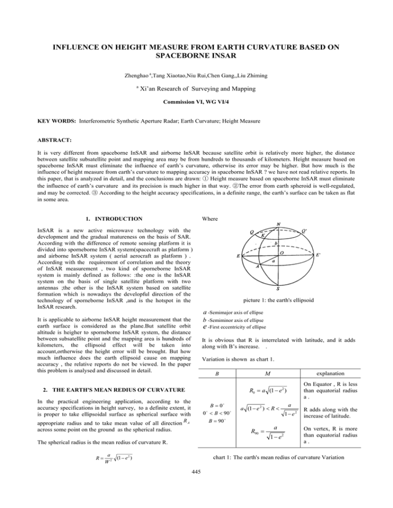
INFLUENCE ON HEIGHT MEASURE FROM EARTH CURVATURE BASED ON SPACEBORNE INSAR Zhenghao a,Tang Xiaotao,Niu Rui,Chen Gang,,Liu Zhiming a Xi’an Research of Surveying and Mapping Commission VI, WG VI/4 KEY WORDS: Interferometric Synthetic Aperture Radar; Earth Curvature; Height Measure ABSTRACT: It is very different from spaceborne InSAR and airborne InSAR because satellite orbit is relatively more higher, the distance between satellite subsatellite point and mapping area may be from hundreds to thousands of kilometers. Height measure based on spaceborne InSAR must eliminate the influence of earth’s curvature, otherwise its error may be higher. But how much is the influence of height measure from earth’s curvature to mapping accuracy in spaceborne InSAR ? we have not read relative reports. In this paper, that is analyzed in detail, and the conclusions are drawn: ① Height measure based on spaceborne InSAR must eliminate the influence of earth’s curvature and its precision is much higher in that way. ②The error from earth spheroid is well-regulated, and may be corrected. ③ According to the height accuracy specifications, in a definite range, the earth’s surface can be taken as flat in some area. Where 1. INTRODUCTION InSAR is a new active microwave technology with the development and the gradual matureness on the basis of SAR. According with the difference of remote sensing platform it is divided into sporneborne InSAR system(spacecraft as platform ) and airborne InSAR system ( aerial aerocraft as platform ) . According with the requirement of correlation and the theory of InSAR measurement , two kind of sporneborne InSAR system is mainly defined as follows: :the one is the InSAR system on the basis of single satellite platform with two antennas ;the other is the InSAR system based on satellite formation which is nowadays the developful direction of the technology of sporneborne InSAR ,and is the hotspot in the InSAR research. It is applicable to airborne InSAR height measurement that the earth surface is considered as the plane.But satellite orbit altitude is heigher to sporneborne InSAR system, the distance between subsatellite point and the mapping area is hundreds of kilometers, the ellipsoid effect will be taken into account,ortherwise the height error will be brought. But how much influence does the earth ellipsoid cause on mapping accuracy , the relative reports do not be viewed. In the paper this problem is analysed and discussed in detail. picture 1: the earth's ellipsoid a -Semimajor axis of ellipse b -Semiminor axis of ellipse e -First eccentricity of ellipse It is obvious that R is interrelated with latitude, and it adds along with B’s increase. . Variation is shown as chart 1. 2. THE EARTH'S MEAN REDIUS OF CURVATURE In the practical engineering application, according to the accuracy specifications in height survey, to a definite extent, it is proper to take ellipsoidal surface as spherical surface with B = 0o 0 < B < 90 B = 90 o o appropriate radius and to take mean value of all direction R A across some point on the ground as the spherical radius. explanation R0 = a (1 − e2 ) On Equator , R is less than equatorial radius a. o a (1 − e 2 ) < R < R90 = The spherical radius is the mean redius of curvature R. R= M B a (1 − e 2 ) W2 a 1 − e2 a 1− e 2 R adds along with the increase of latitude. On vertex, R is more than equatorial radius a. chart 1: The earth's mean redius of curvature Variation 445 The International Archives of the Photogrammetry, Remote Sensing and Spatial Information Sciences. Vol. XXXVII. Part B1. Beijing 2008 Base on InSAR height survey principle, the formula is as follows: 3. THE VARIATION OF MEAN REDIUS OF CURVATURE AND THE INFLUENCE ON HEIGHT SURVEY R12 + ( Re + H ) 2 − 2 cosθR1 ( Re + H ) = ( Re + h) 2 We choose a scene of ERS-1/2 satellite image data of HerBei ShangYi areaed about 50Km* 50 Km . We measure the coordinates of longitude and latitude on the maps, and caculate the mean redius of curvature of earth with Krassovsky ellipsoid parameters by 1954 BeiJing coordinate system ,and then gain the variety of the earth’s mean redius of curvature. (1-1) Caculate the differential coefficient of h to Re , The coordinates of longitude and latitude of the area is as follows: H − 2 cos θR1 − h ∂h = ∂Re h + Re We think Re has errors, and the rest parameters are true. 41. From the law of propagation of mean square errors ,we can get the expression: 41. 41. latitude 2 2 m h2 = k Re m Re 41. 41. While θ = 20.8° , B = 354.56m( the baseline parameter of ERS-1/2 ) , h = 1400m (the area’s mean ground height) , Re = 6374732.39m(the local earth’s mean redius of curvature ), when mRe = 1 m, you can get mh = ±0.87 m. So 1 meter’s error 4 40. 114. 114. 114. 114.4 114. 114.6 114. 114.8 longitude of mean redius of curvature can bring the mean square error of 0.87m . Thus it can be seen, ignoring the variation of earth’s mean redius of curvature will cause quite much the height survey errors. It is required that on InSAR height survey, it need to require that the corresponding ellipsoid radius to the different image coordinates is different too. Picture 2 : the selected area’s coordinates of longitude and latitude It can be seen from picture 3 that the variety of earth’s mean redius of curvature with change of latitude : Then it proves whether we can take the earth’s surface as spherical surface on InSAR Height surcey in selected area . From picture 4, it can be seen that in that way it will cause much more errors, and the errors distribut long the direction of latitude. So it is not feasible to take the earth’s surface as spherical surface in that area coverage . While the latitude adds, the changes of the earth’s mean redius of curvature is linear. When the latitude adds 0.1 degree, the earth’s mean redius of curvature adds nearly 100 meters . So the earth’s mean redius of curvature changes very much along with latitude. How much influence is brought on sporneborne InSAR height survey by so much change? Then it is analyzed quantificationally in detail. 1750 2000 70 1700 1650 variation of earth’s mean redius of curvature 地面点高程 地面点高程 1800 Spot height Spot height 60 1600 1600 1400 50 1550 1500 1200 40 15000 15000 4000 10000 2000 5000 30 方位向坐标 Coordinate in azimuth 0 0 距离向坐标 Coordinate in range 4000 10000 2000 5000 方位向坐标 Coordinate in azimuth 0 0 距离向坐标 Coordinate in range 20 10 40.8 40. 41 41. 41. 41. 41. 41. Picture 4 DEM comparisons true DEM with DEM taken ellipsoidal radius as constant. 41. latitude Picture 3 : Variation of earth’s mean redius of curvature with change of latitude 446 The International Archives of the Photogrammetry, Remote Sensing and Spatial Information Sciences. Vol. XXXVII. Part B1. Beijing 2008 Re is the local radius of the ellipsoid, r0 = Ds 0 + Xs * Ji , Ds 0 range, Xs - the resolution in range Ji -the coordinate in range., can be caculated θ 0 ,So 250 200 300 150 200 InSAR测高误差 InSAR测高误差 Errors of InSAR height survey Errors of InSAR height survey 100 0 -100 -200 -300 15000 100 50 H '0 = (r 0 + 0 -50 -100 the height information of corresponding target Pi can be gotten , if it is taken in the expression of supposing the ground as the -150 4000 10000 ' flat. Where h i is the height relative to the plane of coordinate axes X , it neglects the ellipsoidal influence between the two objects. If ellipsoidal influence between P0 and Pi is taken into -200 2000 5000 方位向坐标 Coordinate -250 Coordinate 距离向坐标 0 0 in azimuth h0 )cos(θ 0 + θ 0' ) cos(θ 0 + θ 0' ) in range 0 5000 10000 方位向坐标 Coordinate in azimuth 15000 hi : account, the true height of Pi is Picture 5 the three-dimension and plane diagram of DEM errors hi = 4. QUANTITATIVE ANALYSIS AND CORRECT OF EARTH’S CURVATURE INFLUENCE IN SPORNEBORNE INSAR HEIGHT SUEVEY In the expression , β = tan -1 ( Δxcosθ 0 ) , Re difference of two object in range . ' To Sporneborne InSAR,because the satellite orbital altitude is comparatively more higher , the distance between subsatellite point and the mapping area is to hundreds of kilometers, mapping area coverage is uauarlly a few of ten kilometers, so the earth’s spheroid effect should be taken into account, otherwise it will bring the height error. When considering the earth’s spheroid influence, the parameters such as satellite platform altitude must be corrected. S αi M rs0 r0 is the coordinate rsi θ0 θ 0' Δx Then we will quantitatively analyze and compare the height measurement errors caused by without regard to the influence of the earth’s curvature in sporneborne InSAR height survey with simulative data . Choose the baseline parameter of ERS1/2, when ***,B = 354.56m,h = 1570m (the mean ground elevation of simulative data ) , Re = 6374732.39m ( the local earth’s mean redius of curvature ) , on the assumption that the ground range resolution is 15meter, the azimuth resolution is 4 meter, so when the area of height measurement is 60KM*60KM , the pixels in range and in azimuth are 4000 and 15000. Simulant DEM is as follows picture 7-a . y B R h i' + ( e − Re) cosβ cosβ ri Pi P0 H0 h 'i h0 x β R eH R ei R e0 1750 1700 1700 1650 1650 Spot height Spot height 地面点高程 N 1750 地面点高程 H 0' 1600 1550 1500 15000 1550 1500 15000 4000 10000 5000 Coordinate 方位向坐标 2000 Coordinate 距离向坐标 0 0 in azimuth in range a 模拟生成的 DEM a DEM obtained by simulation O 1600 4000 10000 5000 2000 Coordinate Coordinate 方位向坐标 距离向坐标 0 0 in azimuth in range b obtained 假设地面为平面生成的 b DEM by supposing theDEM ground as plane Picture 6 geometry sketch diagram of height errors caused from spheroid effect. Picture 7 The comparison DEM obtained by taked the earth’s surface as plane with simlaive DEM In picture 6, Suppose the center of the reference ellipsoid is point O,the distance between M and P0 is r0. In ΔMOP0 , on the basis of the law of cosines , cosθ 0' = The DEM obtained on the condition that the ground is plane is using the above-mentioned transformable expressions showed as picture 7-b. It is nearly no change to compare picture 7-a with picture 7-b . But in fact the two diagrams are different from each other. In order to compare the error ,the two (R e + h0 ) 2 + (R e + H 0 ) 2 − r02 2(R e + h0 )(R e + H 0 ) 447 The International Archives of the Photogrammetry, Remote Sensing and Spatial Information Sciences. Vol. XXXVII. Part B1. Beijing 2008 increase of mapping area. So to sporneborne InSAR system, the influence of the earth’s curvature should taken in account , the height accuracy is more precise. The error came from earth curvature is well-regulated, and may be corrected. At the same time, with the height accuracy specifications, in a definite range, the ground can be treated as the plane . diagrams are subtracted from each other, three- dimensioned picture 8-a are gained to show the difference. From the diagrams we can see: the height error changes in range,it is independent of the azimuth direction and the undulation of terrain . In order to compare them more better, the twodimension diagram of picture 8-a is showed as picture 8-b. From picture 8-b,we can see: with the increase of the ground distance,the height measurement error adds evidently. When the ground distance is about 60 kilometers , InSAR height error due to neglecting the influence of the earth’s curvature is 1.2 meter. Therefore, we can draw the conclusions : no matter what the height of terrain is variational , errors caused by the influence of the earth’s curvature always add with the increase of ground distance. The bigger the area coverage is, the more the errors caused . So to sporneborne InSAR system, the influence of the earth’s curvature should be taken in account , so the precision of height measurement is more precise. In addition, with the height accuracy specifications , in a definite range, the ground may be treated as the plane . REFERENCES Alberto Moreira, Gerhard Krieger, Irena Hajnsek,David Hounam and Marian Werner Sebastian Riegger, Eckard Settelmeyer, “ TanDEM-X: A TerraSAR-X Add-On Satellite for Single-Pass SAR Interferometry ” , 0-7803-8743-0/04 (C)2004 IEEE E.Rodriguez, J.M.Martin, “ Theory and Design of Interferometric Synthetic Aperture Radars”, IEE ProceedingsF, Vol.139, No.2, April 1992.: 147-159. Kong Xiangyuan,Guo Jiming,Liu Zongquan. Foundation of Geodesy[M],WUHAN UNIVERSITY PRESS,2006. 1.4 Martin, M. and Stallard, M. J., “Distributed Satellite Missions and Technologies - The TechSat 21 Program, AIAA Space Technology Conference and Exposition ” , AIAA 99-4479, September 1999. 1.2 1.5 InSAR 测高误差 InSAR 测高误差 Height measurement error Height measurement error 1 1 0.5 0 15000 4000 10000 in azimuth TanDEM-X - Radar Interferometry with unprecedented Accuracy in close Formation Flight with TerraSAR-X Satellites,URL:www.terrasar.de/en/prod/tandem/index.php. 0.6 0.4 Wang Chao,Zhang Hong,Liu Zhi. Satellites Synthetic Aperture Radar Interferometric Measurement . Beijing : Science Press,2002. 0.2 2000 5000 Coordinate 方位向坐标 0.8 0 0 Coordinate 距离向坐标 in range a The three-dimensioned diagram of the a 测高误差的三维显示 height measurement error 0 0 20 40 60 地面距离 ground distance b The height measurement error caused 地面距离的增加引起的测高误差 by the increase of ground distance Zhang Xiaoling,Wang Jianguo,Huang Shunji. Terrain Heght Estimation and Baseline Estimation Technique Research of Interferometric Synthetic Aperture Radar Imaging. Signal Processing,1999,Vol.15,No.4:316-320. Picture 8 DEM errors caused by taken the earth’s surface as palne Zink, M., “ Definition of the TerraSAR-L Cartwheel Constellation ” , ESA TS-SW-ESA-SY-0002, ESTEC, Noordwijk, 2003 5. CONCLUSION From the above analysis ,we can draw the conclusion: no matter what the height of terrain is variational , errors caused by the influence of the earth’s curvature always adds with the 448
