MODELLING LOCAL GPS/LEVELLING GEOID WITH THE ASSESSTMENT OF
MODELLING LOCAL GPS/LEVELLING GEOID WITH THE ASSESSTMENT OF
INVERSE DISTANCE WEIGHTING AND GEOSTATISTICAL KRIGING METHODS
B. Erol a, *, R. N. Çelik a a
ITU, Civil Engineering Faculty, Geodesy Division, 34469 Maslak Istanbul, Turkey - (bihter, celikn)@itu.edu.tr
Commission IV, WG IV/1
KEY WORDS: Geodesy, Modelling, DEM/DTM, Method, Observations, Accuracy, Spatial Infrastructures, GPS
ABSTRACT:
According to wide spread use of satellite based positioning techniques, especially GPS (Global Positioning System), a greater attention has started to be paid to precise determination of geoid models with an aim to replace the geometric levelling measurements with GPS measurements during geodetic and surveying works. In this paper, geoid modelling is evaluated as a surface fitting problem according to GPS and Levelling data and the main focus is modelling the geoid of a local area as an analytical surface to serve practical geodetic applications such as large scale map production, GIS (Geographical Information
Systems) based studies, engineering applications etc. During implementation of the subject, two different interpolation methods,
Inverse Distance Weighting (IDW) and Kriging methods are evaluated according to created program routines. In this paper, in addition to compare these two popular interpolation techniques, mainly it is going to emphasize the applicability of interpolation techniques as a tool for modelling the geoid in a local area precisely using GPS/ Levelling data to serve practical applications of geodesy. Also, the importance of precise local geoid models as a part of geodetic infrastructure is underlined with Turkey example.
1.
INTRODUCTION
To accomplish the transformation between ellipsoidal heights and orthometric heights has become more important since the satellite based positioning techniques, especially GPS (Global
Positioning System), were being used in a wide range of geodetic and surveying applications. Using GPS technique, the positions are determined as related to geocentric WGS84
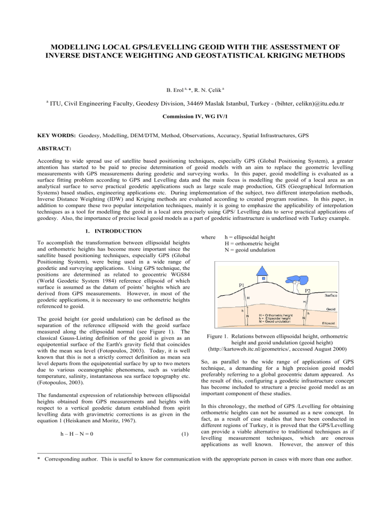
(World Geodetic System 1984) reference ellipsoid of which where h = ellipsoidal height
H = orthometric height
N = geoid undulation surface is assumed as the datum of points’ heights which are derived from GPS measurements. However, in most of the geodetic applications, it is necessary to use orthometric heights referenced to geoid.
The geoid height (or geoid undulation) can be defined as the separation of the reference ellipsoid with the geoid surface measured along the ellipsoidal normal (see Figure 1). The classical Gauss-Listing definition of the geoid is given as an equipotential surface of the Earth's gravity field that coincides with the mean sea level (Fotopoulos, 2003). Today, it is well known that this is not a strictly correct definition as mean sea level departs from the equipotential surface by up to two meters due to various oceanographic phenomena, such as variable temperature, salinity, instantaneous sea surface topography etc.
(Fotopoulos, 2003).
The fundamental expression of relationship between ellipsoidal heights obtained from GPS measurements and heights with respect to a vertical geodetic datum established from spirit levelling data with gravimetric corrections is as given in the equation 1 (Heiskanen and Moritz, 1967). h – H – N = 0 (1) height and geoid undulation (geoid height) important component of these studies.
Figure 1. Relations between ellipsoidal height, orthometric
(http://kartoweb.itc.nl/geometrics/, accessed August 2000)
So, as parallel to the wide range of applications of GPS technique, a demanding for a high precision geoid model preferably referring to a global geocentric datum appeared. As the result of this, configuring a geodetic infrastructure concept has become included to structure a precise geoid model as an
In this chronology, the method of GPS /Levelling for obtaining orthometric heights can not be assumed as a new concept. In fact, as a result of case studies that have been conducted in different regions of Turkey, it is proved that the GPS/Levelling can provide a viable alternative to traditional techniques as if levelling measurement techniques, which are onerous applications as well known. However, the answer of this
* Corresponding author. This is useful to know for communication with the appropriate person in cases with more than one author.
question “What accuracy level can be reached using this approach?” is still an improvable issue as related to many conditions and one of them is used method of geoid modelling.
In this paper, geoid modelling is evaluated as a surface fitting problem according to GPS and Levelling data and the focus is modelling the geoid of a local area as an analytical surface to serve practical geodetic applications. During implementation of the subject, two different interpolation methods are considered.
There are several interpolation methods to transform point data, however, it is important to determine, which one is more appropriate and give better and clear parameter solution for the implemented data and the problem. Modern spatial interpolation methods are based on geometric and geostatistical aspects.
Here in, two interpolation methods, Inverse Distance Weighting and Geostatistical Kriging were applied for generating a digital geoid heights model in a local area. The study area is 45 x 50 km 2 and covered by heterogeneous and appropriately distributed 301 reference points of which positions are known in ITRF datum and orthometric heights are in Turkish National
Vertical Datum.
Density of the reference points is appropriate for the geoid modelling in the region (1 point\ 3 km). There is not a specific reason for appreciating especially these two interpolation methods in the study. The main purpose of the study is to emphasize the necessity of a precise geoid model to serve practical purposes of geodesy. The presented interpolation methods were programmed as to be computation modules of a geoid modelling software and the results of the computation algorithms are going to be mentioned more than the mathematical bases of the methods because of that they can be reached in the literature easily (see Isaaks and Srivastava, 1989;
Watson, 1992; Yanalak 1997).
2.
LOCAL PRECISE GEOID MODELS TO SERVE
PRACTICAL GEODETIC APPLICATIONS
A precise geoid model is an important part of the geodetic infrastructure. Geodetic infrastructure includes whole of the geodetic networks, which realize the coordinate systems and datum definitions as the bases of geodetic works (Aksoy et al.,
1999).
Restructuring and revising efforts of geodetic infrastructure continues in Turkey and also structuring the national geoid model of Turkey is a part of these efforts. So far, regional geoid model of Turkey revised several times. The latest geoid model is “Turkey Geoid 1999A” (TG99A). TG99A geoid model satisfies necessary accuracy for producing large scale maps and routine surveying applications. However, in some parts, this gravimetric based refined geoid model stays weak in accuracy for practical geodetic applications.
In this case, determining local precise geoid models using more intensive data in areas where national geoid model does not have sufficient absolute accuracy is purposed as a solution. By this way, weaker parts of the national geoid model will be supported by local these local solutions and the component of geodetic infrastructure as well.
From this view point, to serve the practical geodetic and surveying applications, determining the geoid model of a limited area as an analytical surface using homogeneously distributed and GPS/Levelling reference points with appropriate density constitutes the subject of this study.
3.
SURFACE FITTING METHODS IN MODELLING
GPS/ LEVELLING GEOID IN A LOCAL AREA
Among the geoid modelling techniques as based on geometrical approach, fitting a surface, which depends on the reference points that are chosen in the critical and characteristic locations of the field to represent trend of geoid surface, is a common method in small areas for local studies. Representing geoid heights as mathematically formulated surface and calculating the geoid heights in new measured points according to GPS technique constitutes the idea in these kinds of studies (Erol and
Çelik, 2004).
However, in a local area, determined geoid model with surface fitting technique works with in the area that surrounded and covered by reference points properly and these kinds of models does not provide reliable results for the extrapolation points.
One another important handicap in local geoid determination is datum inconsistency problem but in this study, this problem is not going to be considered because of the focus is on testing surface fitting algorithms as a geometrical approach for modelling a local geoid according to GPS and Levelling data.
There are several important factors that affect the accuracy of
GPS/ Levelling geoid model (Erol and Çelik, 2004). These are;
− Distribution and number of reference stations (GPS/
Levelling stations) (these points must be distributed homogeneously to the coverage area of the model and have to be chosen to figure out the changes of geoid surface).
− The accuracy of GPS derived ellipsoidal heights (h) and the heights derived from levelling measurements (H).
− Characteristic of the geoid surface in the area.
− Used method while modelling the geoid (researches showed that there is not a unique model works properly for realizing the geoid surface of different areas) (Erol and Çelik, 2004).
Interpolation methods are most common approaches that are used while modelling the geoid heights (N) in a local area.
There are different interpolation algorithms and each of them can have different results when interpreting your data. Inverse distance weighting and geostatistical Kriging are two of them and very popular also in modelling spatial data as well as in evaluation of some other data sets of different disciplines
(Anonym, 1999).
In this study these two methods have been chosen to model the geoid undulations in a local area and to prove that they give satisfying results to serve practical applications in geodesy. By applying them, the provided results and the performances of both are compared each other. These two interpolation methods constitutes solution algorithms of a geoid modelling software that is still in developing process as the product of a thesis study, and because of that in this study, these two methods were evaluated to investigate and compare the performance of interpolation algorithms in local geoid modelling.
Inverse Distance Weighting (IDW) is a weighted average interpolator. The power parameter controls how the weighting factors drop off as distance from the reference point increases
(Anonym, 1999). This is fast and has relatively simple mathematical algorithm.
In equation 2 and 3, the relations are given to calculate the geoid undulation point k as related to the surrounding reference points i=1,2,3 . . n. The point k and neighbor reference points contributed to the computation of geoid undulation value of point k according to certain weight values are illustrated in model. The variogram model mathematically specifies the spatial variability of the data set. The weights of reference points, which are applied to data points during calculations, are direct functions of the variogram model (Anonym, 1999).
Computing an experimental variogram from your data is the only certain way to determine which variogram model you should use. A detailed variogram analysis can offer insights
Figure 2 (in the figure i=7). n
∑
i = 1 i n
∑
= 1 into the data that would not otherwise be available, and it allows for an objective assessment of the variogram scale and anisotropy (Anonym, 1999). In an other word structural effects
N' =
N i
P i
N i
P i
P i (2) basis of variations as a function of distance. A mathematical where N ’ = geoid undulation value of point k
= geoid undulation value of i th
= weight of i th reference point
reference point model is fit to this data in order to interpolate unknown values at other locations. Spatial variation may also be more predominate in certain directions. Anisotropy implies the preferred direction of higher or lower continuity between data points. Anisotropy is applied by specifying an anisotropy ratio which states: “Give more weighting to points located along one axis versus points located along another axis”. The relative
P
i
=
d
1
i n
(3) where d i
= distance between interpolation point k and i reference point in kilometer th
The method based on the recognition that the spatial variation of any property, known as a ‘regionalized variable’, is too irregular to be modeled by a smooth mathematical function but n = power of the distance, it can be 1, 2, 3 or 4. In the can be described better by a stochastic surface. The case study, n has chosen 3 empirically. interpolation proceeds by first exploring and then modelling the stochastic aspects of the regionalized variable. The resulting information is then used to estimate weights for interpolation
1 points and in the Kriging method, the logic is similar.
2
7
6 k
3
5
4
Figure 2. Interpolation point k of which geoid undulation value is going to be computed and neighbor reference points that contributes the computation of geoid undulation at point k.
In general, it is not usual to contribute all the reference points to the computation of geoid undulation value according to IDW interpolation method. Because of that a boundary is described to surround an area to include the reference points which are going to be contribute to the computation. There are several ways to describe the boundary. One of them is to determine a circle as being the interpolation point in the center of it. The radius of the circle is determined according to conditions of the cover area of the study and in this example a 3 km radius was described by considering the topographical properties of the local area.
Kriging is a geostatistical approach to interpolate data based upon spatial variance and has proven useful and popular in many fields in geodesy as well. This is a considerably flexible method and similar to IDW whereby proximity and influence are assumed to be related, Kriging recognizes that spatial variance is a function of distance (Wilson, 1996). It can be custom fit to a data set by specifying the appropriate variogram
Geostatistics, similar to any form of statistics, has two main criteria which must be met. All statistical models have assumptions which need to be recognized and expectantly meet before the model is used. The second criterion, a statistical analysis, to perform on the data set, should be explored for normality and spatial variance with data transformations applied as necessarily. Geostatistical assumptions are reviewed by Issaaks and Srivastava, 1989. Regionalized variable theory assumes that spatial variation is the sum of three components
(Wilson, 1996);
− A first order effect, in another word, known as a ‘structural component’, which is defined by a constant trend. This part gives trend and is depicted graphically in a variogram as the
“sill”. It implies that at these values of the ‘lag’ (distance) there is no spatial dependence between the data points based on variance.
− A second order effect is defined as a random spatially correlated component. Referred to as “variance of differences” and this is a function of distance between sites
(the distance is called as “lag”). Variance increases from random noise (the nugget) to the sill as distance increases.
The distance is important as it specifies the distance site differences are spatially dependent.
− Random noise or residual error, known as the “nugget”.
For a detailed explanation about Kriging Method Isaaks and
Srivastava, 1989; Watson, 1992 and Deutsch and Journel, 1992 can be seen.
In the case study, universal Kriging method was applied with linear variogram model. The results of the case study will be given under following title.
4.
NUMERICAL EXAMPLE
The study has been carried out with in 45 x 50 km 2 local region using GPS /Levelling data. The area is in the west of Turkey near Agean Sea, Izmir Metropolitan Region. For modeling the geoid in the area as an analytical surface, two interpolation methods were applied. Mathematical algorithms of these two interpolation methods have been programmed as to comprise the computation modules of a Local Geoid Modeling software, however, the mentioned software has not been completed yet, on the other hand it is planed to give the final version to the software by the year of 2005.
In the area, 181 of totally 301 GPS/ Levelling points were decided to use as reference points (modelling benchmarks), which contributes the computation of new points according to appropriate interpolation method, and rest 120 GPS/ Levelling points (testing benchmarks) were used for testing the developed interpolation algorithms according to IDW and Kriging
Methods. During the selection of test points set topography of the region and also keeping the homogeneous distribution of reference points set were considered. The distribution of both point sets can be seen in Figure 3.
REFERENCE POINTS OF IZMIR LOCAL GEOID
38.5
38.45
38.4
38.35
38.3
38.25
26.8
26.85
26.9
26.95
27 27.05
LONGITUDE
27.1
27.15
27.2
27.25
27.3
Modeling Benchmarks
Testing Benchmarks
Figure 3. The distributions of modelling benchmarks and test benchmarks in the area of study
(Erol and Çelik, 2004).
IDW and Kriging interpolation algorithms were applied according to developed program codes. IDW interpolation method has a simple computation algorithm than Kriging method. However, the most complicated part is modelling the variogram, after that the rest of the process is similar to IDW in that prescribed weights control the interpolation. Variogram is an important tool to explore spatial data sets. According to handled results:
According to IDW model and using the previously mentioned modeling parameters, the model was tested for 121 test points.
The test was carried out by analyzing the difference between computed geoid heights from the model and geoid heights from measurements. As the result of these analysis, it was seen that the model fitted the data with ±3.42 cm root means square error.
This is also an indicator for usability of the model for computing the new points.
While Universal Kriging method was applied with the same data set, it was seen that the model fitted the data with ±3.07 cm root means square error. If these results are compared each other, it can be said that Kriging method can handle the data better than IDW.
About the computation time, the performance of both techniques are similar each other. However, as it is mentioned before, the algorithm of Kriging method is much more complex than IDW for programming.
At the end of the analysis, it was decided that both interpolation method gave reasonable results for this local area and they are applicable for modelling the geoid of this area as an analytical surface and to serve practical geodetic applications. On the other hand, according to researches it mustn’t be neglected that the eligibility of a mathematical model to an area while modeling the GPS/ Levelling geoid is strictly depends on the properties of study area. So, it is necessary to test a developed model that if it is appropriate for modelling the geoid of an area, before applying the new data.
5.
CONCULISON AND FUTURE WORKS
It is obvious that after GPS techniques have become wide spread in geodetic purposes, geoid model determination for especially use in practical applications of geodesy has an increased importance. So, this study’s main was to produce some solutions to practical applications, such as large scale map production, GIS applications, engineering surveying applications etc. especially at a national level.
Therefore, to test the performances and applicability of surface fitting methods in geoid modelling using GPS/ Levelling measurements in a local area, this study was carried out.
In the study, two interpolation techniques, Inverse Distance
Weighting and Kriging were applied separately. In both applications, 181 GPS/ Levelling points were used as a reference points set for generating the model and another 121
GPS/ Levelling points as test points set were used to test the structured models.
In the results, it has been seen that both interpolation methods are applicable for modelling the geoid of study area as an analytical surface; however, Kriging method fits the data better than IDW method according to test criteria.
The computation time is similar for both methods, while the program codes run. On the other hand, Kriging method has much more complex computation algorithm than IDW method has.
Local geoid models have a special importance especially for geodetic infrastructure of Turkey. Because, regional geoid model of Turkey hasn’t got homogeneous accuracy in every part of the Turkey. Because of that in some part of the country, it is necessary to be supported with precise local geoid models.
Surface fitting methods are very practical with this respect; however, it is important to assess the appropriate surface fitting approach. So it is necessary to test the model before applying the new points.
As the future works it is planning to program some other data modeling techniques to add the developing geoid modelling software. Also to combine regional geoid model and local geoid model to create a whole and improved geoid model for the study areas is planning.
References
Aksoy, A., Ayan, T., Çelik, R., N., Demirel, H., Deniz, R.,
Gürkan, O., 1999. in Turkish )
Geodetic Infrastructure for Geographic
Information Systems Under the Enlightening of Recent
Developments and Exposed Problems, Chamber of Surveying and Cadastre Engineers of Turkey, Education Serial, Istanbul,
Turkey (
Anonym, 1999.
Erol, B., Çelik, R. N., 2003. Investigation on Local Precise
Geoid Determination Using GPS and Levelling Data,
International Symposium of Modern Technologies, Education and Professional Practice in Globalizing World , 6-8 November,
Sofia, Bulgaria
Golden Software, Surfer 8, User’s Guide
Deutsch, C. V., Journal, A. G., 1992.
Software Library and User’s Guide
ISBN 0-19-507392-4, New York, USA
GSLIB Geostatistical
Oxford University Press,
Erol B., Erol S., Çelik R. N., 2003. Using GPS and Leveling
Data in Local Precise Geoid Determination and Case Study,
Abstract, Geophysical Research Abstracts, Vol. 5, 6-11
:
Contouring and 3D surface mapping for scientist and engineers,
Colorado, USA
Ayan, T., Deniz, R., Çelik, R., N., Denli, H., H., Özlüdemir,
M., T., Erol, S., Özöner, B., Aky ı maz, O., Güney, C., 2001.
Izmir Geodetic Reference System-2001 (IzGRS-2001),
Technical Report, Istanbul Technical University-Civil
Engineering Faculty, 2000/2294, Istanbul, Turkey ( in Turkish )
Erol, B., Çelik, R. N., 2004. Precise Local Geoid
Determination to Make GPS Technique more Effective in
Practical Applications of Geodesy, FIG Working Week 2004 ,
22-27 May, Athens, Greece
Fotopoulos, G., 2003. An Analysis on the Optimal Combination of Geoid, Orthometric and Ellipsoidal Height Data , PhD
Thesis, University of Calgary, Department of Geomatics
Engineering, Canada
Heiskanen, W. A., Moritz, H. 1967. Physical Geodesy W.H.
Freeman and Company San Francisco
Isaaks, E. H., Srivastava, R. M., 1989. An Introduction to
Applied Geostatistics , Oxford University Press, Oxford
Yanalak, M., 1997. Say ı sal Arazi Modellerinde Hacim
Hesaplar ı , Istanbul Technical University, Institute of Science and Technology, PhD Thesis, Istanbul ( in Turkish )
Watson D. F., 1992. Contouring: A Guide To The Analysis And
Display Of Spatial Data , Pergamon Press, ISBN 0 08 040286 0,
New York, USA
Wilson, C., 1996. Assessment of Two Interpolation Methods,
Inverse Distance Weighting and Geostatistical Kriging,
University of Ottawa, course # geg-5306, Canada
