GIS/LIS AS A MULTIPURPOSE SYSTEM
advertisement

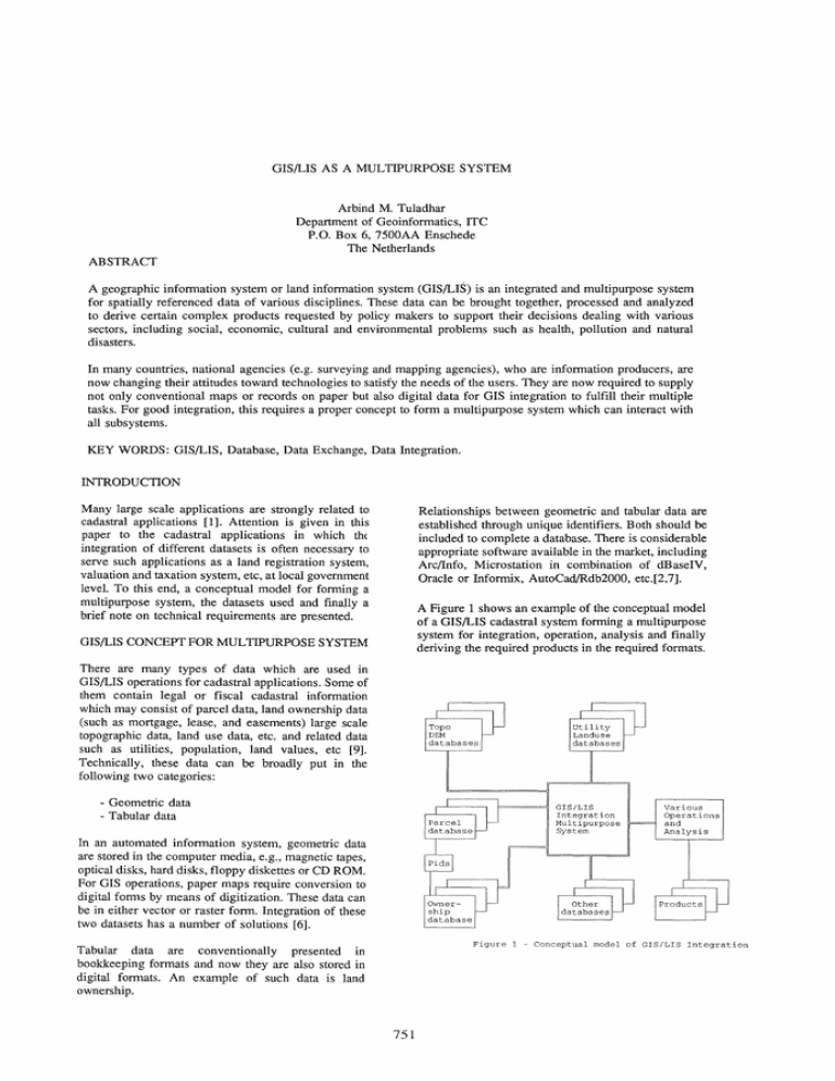
GIS/LIS AS A MULTIPURPOSE SYSTEM Arbind M. Tuladhar Department of Geoinformatics, ITC P.o. Box 6, 7500AA Enschede The Netherlands ABSTRACT A geographic information system or land information system (GIS/LIS) is an integrated and multipurpose system for spatially referenced data of various disciplines. These data can be brought together, processed and analyzed to derive certain complex products requested by policy makers to support their decisions dealing with various sectors, including social, economic, cultural and environmental problems such as health, pollution and natural disasters. In many countries, national agencies (e.g. surveying and mapping agencies), who are information producers, are now changing their attitudes toward technologies to satisfy the needs of the users. They are now required to supply not only conventional maps or records on paper but also digital data for GIS integration to fulfill their multiple tasks. For good integration, this requires a proper concept to form a multipurpose system which can interact with all subsystems. KEY WORDS: GIS/LIS, Database, Data Exchange, Data Integration. INTRODUCTION Many large scale applications are strongly related to cadastral applications [1]. Attention is given in this paper to the cadastral applications in which the integration of different datasets is often necessary to serve such applications as a land registration system, valuation and taxation system, etc, at local government level. To this end, a conceptual model for forming a multipurpose system, the datasets used and finaHy a brief note on technical requirements are presented. Relationships between geometric and tabular data are established through unique identifiers. Both should be included to complete a database. There is considerable appropriate software available in the market, including Arc/Info, Microstation in combination of dBaseIV, Oracle or Informix, AutoCad/Rdb2000, etc.[2,7]. A Figure 1 shows an example of the conceptual model of a GIS/LIS cadastral system forming a multipurpose system for integration, operation, analysis and finally deriving the required products in the required formats. GIS/LIS CONCEPT FOR MULTIPURPOSE SYSTEM There are many types of data which are used in GIS/LIS operations for cadastral applications. Some of them contain legal or fiscal cadastral information which may consist of parcel data, land ownership data (such as mortgage, lease, and easements) large scale topographic data, land use data, etc. and related data such as utilities, population, land values, etc [9]. Technically, these data can be broadly put in the following two categories: - Geometric data - Tabular data GIS/LIS Integration Multipurpose System Various Operations and Analysis In an automated information system, geometric data are stored in the computer media, e.g., magnetic tapes, optical disks, hard disks, floppy diskettes or CD ROM. For GIS operations, paper maps require conversion to digital forms by means of digitization. These data can be in either vector or raster form. Integration of these two datasets has a number of solutions [6]. Figure 1 - Conceptual model of GIS/LIS Integration Tabular data are conventionally presented in bookkeeping formats and now they are also stored in digital formats. An example of such data is land ownership. 751 This model uses a concept of a distributed database system. A core part for data interchange to and from all subsystems is realized through the GISILIS system in which data are accessed through unique keys which relate object items of the various databases. (f) There are many other databases which are generated for specialized applications which may be integrated in GISILIS environments [8]. In all above cases we can imagine the data complexity in term of functional relationships for one or many application purposes. DATABASES AND ATIRIBUTES In this above conceptual model, each database is managed and maintained by a specialized group or department within a GISILIS environment to fulfill its assigned tasks. There can be more databases than shown in the above figure, depending upon the applications. Some of them are described below. TECHNICAL REQUIREMENTS MULTIPURPOSE SYSTEM OF GISILIS Generally speaking the integration of different geographic data requires a so called "standard data exchange system", because the different users need to access the different geographic data produced by the different disciplines to derive complex products used for various purposes. However, this can be only one of the requirements if we think in a broader context of information system development. a) The parcel database contains the measurements of each individual parcel, its geographic location, parcel address, area, neighbourhood parcel information, etc. These data are in both graphic environment and tabular form. Depending on the software used they can be either a spaghetti or topologic structure. In both cases information such as address, areas and neighbourhood parcels must be stored in the tabular form. Depending on the application the logical structure can be very complex. Each parcel has its unique identifier which relates the land ownership database, as shown in the figure 1 above. The following can be given as important requirements to be considered in GIS integration: - b) The legal ownership database consists of legal owner records and lease or mortgage information in tabular formats. The logical relationships are maintained to provide the correct information for each parcel and owner. Ownership registry can be for deeds, titles, etc. These records are related to parcel identifiers in the parcel database. Conceptual framework of databases Information models Data dictionary Data quality Standard data exchange system The conceptual framework of databases is necessary to realize the conceptual relationship of all subsystems in a GIS system. This is very important for defining the various concepts and work contents involved in individual databases. A network of all subsystems should be established to fulfill multi-tasks. The purpose of information modelling is to define what object items are included in each databases. This should include classification and coding standards for objects and lead toward a preparation of data dictionary. At this stage it is necessary to define logical models showing logical relationships for each database. c) The large-scale topographic database consists of information on roads, rivers, buildings, parks, landmarks, etc. These data are usually collected using a high precision photogrammetric plotter and largescale aerial photographs or by cartographic digitizing of existing maps. These data are in vector format which can be structured either in spaghetti or topologic structures. A data dictionary is the standard definition of each object and contains varieties of information such as object class, object items, object name, object code, object access method, object storage, etc. This dictionary is meant to be a standard used for all subsystems during database creation and maintenance. d) The utility database contains information on electrical lines, water pipelines, sewerage lines, etc. together with detailed information about these lines in tabular format. e) The land use database is an important component to be used in LIS applications, especially if we have to value a piece of lands for taxation purposes. In this example, it indicates type of land use for certain homogeneous units. The land use database can best be made by interpretation of aerial photographs. It is also possible to use satellite images and ground truthing. The data can be in either vector or raster format. Data quality is another item to be considered, because the data come from various sources of different quality. It is necessary to give quality information for each data class. This can assist in estimating the qualities of products as a resulting from GISILIS operations. 752 A standard data exchange system makes it possible to transfer data to and from all subsystems without loss of information. It is also possible to attain security of information. All data and information must be exchanged through this standard system and only authorized persons can access information. CONCLUSION In conclusion, we can emphasis that implementation of such an automated multipurpose information system is both economical and beneficial. REFERENCES 1. Aalders, H. and Koen, T. (1992), LIS/GIS in the Netherlands: state of the art. Mapping awareness & GIS in Europe Vol. 6 No.1 January/February 1992. 2. Arc/info Users Manual (1985), ESRI, California, USA. 3. AURISA (1985), Report of the working group on statewide parcel-based Land information system in Australasia, Sydney NSW. 4. Cederholm, T.(1991), The Swedish Approach to GIS Standardization. Mapping the Nations Proceedings, Vol 2, ICA 15th conference and 9th general assembly, Bournemouth, UK, 1991. 5. Coelman, B., Drummond, J. and Vugt, R. V . (1992) RISE - the heart of Integrated Municipal Spatial Information System. Mapping awareness & GIS in Europe Vol. 6 No 1 January/February 1992. 6. Ehlers, M. and Greenlee, D. (1991), Integration of remote sensing and GIS: data and data access. Photogrammetric engineering & remote sensing, Vol 57, No.6, June 1991, pp. 669-675. 7. Microstation PC Manuals (1991), Intergraph Corporation, Huntsville, USA. 8. Levainen, K. (1986), On the databases and registers of the technical sector of the middel-sized Finnish city. Surveying Science in Finland, 1986, no. 1, pp. 26-42. 9. Muller, A. (1988), Land Information Systems and Taxation of Properties in developing countries: A pragmatic approach. Presented at world congress III, Computer assisted valuation and land information systems, Aug 7-12, 1988, Cambridge, Massachusetts. 753


