Schedule of Proposed Action (SOPA) 10/01/2014 to 12/31/2014
Project Name
Schedule of Proposed Action (SOPA)
10/01/2014 to 12/31/2014
Grand Mesa, Uncompahgre and Gunnison National Forests
This report contains the best available information at the time of publication. Questions may be directed to the Project Contact.
Project Purpose Planning Status Decision
Expected
Implementation
Project Contact
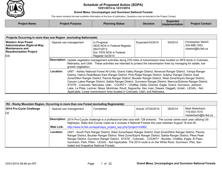
Projects Occurring in more than one Region (excluding Nationwide)
Western Area Power
Administration Right-of-Way
Maintenance and
Reauthorization Project
EIS
- Special use management In Progress:
DEIS NOA in Federal Register
09/27/2013
Est. FEIS NOA in Federal
Register 02/2014
Expected:03/2014 04/2014 Christopher Wehrli
435-896-1053 clwehrli@fs.fed.us
Description: Update vegetation management activities along 278 miles of transmission lines located on NFS lands in Colorado,
Nebraska, and Utah. These activities are intended to protect the transmission lines by managing for stable, low growth vegetation.
Location: UNIT - Ashley National Forest All Units, Grand Valley Ranger District, Norwood Ranger District, Yampa Ranger
District, Hahns Peak/Bears Ears Ranger District, Pine Ridge Ranger District, Sulphur Ranger District, East
Zone/Dillon Ranger District, Paonia Ranger District, Boulder Ranger District, West Zone/Sopris Ranger District,
Canyon Lakes Ranger District, Salida Ranger District, Gunnison Ranger District, Mancos/Dolores Ranger District.
STATE - Colorado, Nebraska, Utah. COUNTY - Chaffee, Delta, Dolores, Eagle, Grand, Gunnison, Jackson,
Lake, La Plata, Larimer, Mesa, Montrose, Routt, Saguache, San Juan, Dawes, Daggett, Uintah. LEGAL - Not
Applicable. Linear transmission lines located in Colorado, Utah, and Nebraska.
R2 - Rocky Mountain Region, Occurring in more than one Forest (excluding Regionwide)
2014 Pro-Cycle Challenge
CE
- Special use management Completed Actual: 07/24/2014 08/2014 Neal Weierbach
719-553-1510 nweierbach@fs.fed.us
Description: 2014 Pro-Cycyle challenge is a professional bike race with 128 entrants. The course varies each year utilizing US
Highways, State and County roads as it crosses 4 National Forests this year between August 18 and 26.
Web Link: http://www.fs.fed.us/nepa/nepa_project_exp.php?project=43962
Location: UNIT - South Park Ranger District, West Zone/Aspen Ranger District, East Zone/Dillon Ranger District, Paonia
Ranger District, Boulder Ranger District, West Zone/Sopris Ranger District, Salida Ranger District, Pikes Peak
Ranger District, Gunnison Ranger District. STATE - Colorado. COUNTY - Boulder, Chaffee, Eagle, El Paso,
Gunnison, Park, Pitkin. LEGAL - Not Applicable. The 2014 route is on the White River, Gunnison, Pike, San
Isabel and Arapahoe National Forests.
10/01/2014 08:46 am MT Page 1 of 22 Grand Mesa, Uncompahgre and Gunnison National Forests
Project Name Project Purpose Planning Status Decision
Expected
Implementation
Project Contact
R2 - Rocky Mountain Region, Occurring in more than one Forest (excluding Regionwide)
Continental Divide National
Scenic Trail Addition
EA
- Recreation management
- Facility management
On Hold N/A N/A Niccole Mortenson
970-874-6616 nmortenson@fs.fed.us
Description: Relocate approximately 32 miles of the Continental Divide National Scenic Trail off of Forest Service roads.
Proposed trail location is at or near the actual divide. Up to 3 trail heads will be constructed along the new section of trail.
Web Link: http://www.fs.fed.us/nepa/nepa_project_exp.php?project=31283
Tri-State Montrose-Nucla-
Cahone Transmission
Improvement Project
EA
Location: UNIT - Saguache Ranger District, Gunnison Ranger District. STATE - Colorado. COUNTY - Saguache.
LEGAL - Not Applicable. From Lujan Pass on the east to the LaGarita Wilderness on the west, Rio Grande and
GMUG National Forests.
- Special use management In Progress:
Comment Period Public Notice
05/05/2014
Est. Objection Period Legal
Notice 09/2015
Expected:10/2015 04/2016 Liz Mauch
970-242-8211 lmauch@fs.fed.us
Description: Tri-State Generation and Transmission Association has proposed upgrades to existing Montrose-Nucla-Cahone transmission line and 3 substations crossing private, state and federal lands.
Web Link: http://blm.gov/dvld
Location: UNIT - Norwood Ranger District, Ouray Ranger District, Mancos/Dolores Ranger District. STATE - Colorado.
COUNTY - Dolores, Montrose, Ouray, San Miguel. LEGAL - Not Applicable. Existing Tri-State transmission corridor on Grand Mesa, Uncompahgre and Gunnsion and San Juan National Forests, Southwestern Distrct
Bureau of Land Management and private lands.
10/01/2014 08:46 am MT Page 2 of 22 Grand Mesa, Uncompahgre and Gunnison National Forests
Project Name Project Purpose Planning Status Decision
Expected
Implementation
Project Contact
R2 - Rocky Mountain Region, Occurring in more than one Forest (excluding Regionwide)
Wilson Peak Land Exchange
EA
- Land acquisition Expected:12/2014 http://www.fs.fed.us/nepa/nepa_project_exp.php?project=43154
02/2015 Dee Closson
970-327-4261 X4341 daclosson@fs.fed.us
Description:
Non-federal Parties propose to convey five separate parcels of non-federal land containing a total of approximately 681 acres to the United States in exchange for four federal properties containing a total of approximately 303 acres of equal value.
Web Link:
In Progress:
Comment Period Public Notice
11/22/2013
Est. Objection Period Legal
Notice 10/2014
Location: UNIT - Norwood Ranger District, Gunnison Ranger District, Mancos/Dolores Ranger District. STATE - Colorado.
COUNTY - Dolores, Gunnison, Saguache, San Miguel. LEGAL - Non-federal: T41N, R10W, sec 4-5; T42N,
R10W, sec 31-33; T43N, R1E, sec 1-2 ; T41N, R9W, sec 3&10 ; T42N, R9W, sec 15, 21, 22 & 28
Federal: T42N, R9W, sec. 17, 20-22, 28; T42 N, R10, sec 18. Non-federal parcels: Upper Silver Pick Basin,Elk
Creek Basin, Cochetopa Creek, Yellow Mountain, and Alta Lakes. Federal parcels: near State Highway 145, Alta
Lakes and Wilson Mesa.
Grand Mesa, Uncompahgre and Gunnison National Forests, Forestwide (excluding Projects occurring in more than one
Forest)
Oil and Gas Leasing Revision
EIS
R2 - Rocky Mountain Region
- Land management planning
- Minerals and Geology
On Hold N/A N/A Ryan Taylor
970-527-4131 rztaylor@fs.fed.us
Description: Revise 1993 Grand Mesa Uncompahgre and Gunnison National Forest Oil and Gas Leasing EIS decision to address changed conditions, revised leasing stipulations, and land availability.
Web Link: http://www.fs.fed.us/nepa/nepa_project_exp.php?project=33481
Location: UNIT - Grand Mesa Uncompahgre and Gunnison National Forest All Units. STATE - Colorado. COUNTY -
Delta, Garfield, Gunnison, Mesa, Montrose, Ouray, San Miguel. Grand Mesa, Uncompahgre and Gunnison
National Forests.
10/01/2014 08:46 am MT Page 3 of 22 Grand Mesa, Uncompahgre and Gunnison National Forests
Project Name Project Purpose Planning Status Decision
Expected
Implementation
Project Contact
Grand Mesa, Uncompahgre and Gunnison National Forests, Forestwide (excluding Projects occurring in more than one
Forest)
Qwest Phone Lines
CE
- Special use management In Progress:
Scoping Start 11/15/2012
Expected:09/2014
R2 - Rocky Mountain Region
10/2014 Liz Mauch
970-240-5405 lmauch@fs.fed.us
Description: Consolidate Qwest Permits with other districts on GMUG.
Web Link: http://www.fs.fed.us/nepa/nepa_project_exp.php?project=32095
Spruce Beetle Epidemic and
Aspen Decline Management
Response
EIS
Location: UNIT - Grand Mesa Uncompahgre and Gunnison National Forest All Units. STATE - Colorado. COUNTY -
Delta, Gunnison, Hinsdale, Mesa, Montrose, Ouray, Saguache, San Miguel. Grand Mesa NF, Gunnison NF,
Uncompaghre NF.
- Forest products
- Vegetation management
(other than forest products)
- Fuels management
In Progress:
NOI in Federal Register
07/31/2013
Est. DEIS NOA in Federal
Register 11/2014
Expected:09/2015 10/2015 Scott Williams
760-382-7371 scottwilliams@fs.fed.us
Description:
Approximately 300,000 acres of forest have experienced mortality from insects and disease agents over the past decade. This planning effort will allow us to act adaptively, proactively and efficiently to changing forest health conditions.
Web Link: http://www.fs.fed.us/nepa/nepa_project_exp.php?project=42387
Location: UNIT - Grand Mesa Uncompahgre and Gunnison National Forest All Units. STATE - Colorado. COUNTY -
Delta, Garfield, Gunnison, Hinsdale, Mesa, Montrose, Ouray, Saguache, San Miguel. LEGAL - Not Applicable.
Forest currently estimates that between 250,000-350,000 acres will be analyzed for both commercial harvest and non-commercial treatments (mechanical and prescribed fire).
Grand Mesa, Uncompahgre and Gunnison National Forests Grand Valley Ranger District (excluding Projects occurring in more than one District)
Blanche Park Reservoir Dam
Rehabilitation
CE
R2 - Rocky Mountain Region
- Special use management In Progress:
Scoping Start 04/20/2012
Expected:11/2014 06/2015 Linda Bledsoe
970-263-5802 lbledsoe@fs.fed.us
Description:
Issuance of short-term special use permit for rehabilitation of existing dam and construction of access route.
Web Link: http://www.fs.fed.us/nepa/nepa_project_exp.php?project=13530
Location: UNIT - Grand Valley Ranger District. STATE - Colorado. COUNTY - Delta. LEGAL - Section 35, T. 11 S., R.
94 W., 6th P.M. Approximately 12 miles northeast of Cedaredge, CO. near Park Reservoir.
10/01/2014 08:46 am MT Page 4 of 22 Grand Mesa, Uncompahgre and Gunnison National Forests
Project Name Project Purpose Planning Status Decision
Expected
Implementation
Project Contact
Grand Mesa, Uncompahgre and Gunnison National Forests Grand Valley Ranger District (excluding Projects occurring in more than one District)
Collbran Development, Inc.,
Sewer Line Special Use Permit
CE
R2 - Rocky Mountain Region
- Land ownership management
- Special use management
On Hold N/A N/A Linda Bledsoe
970-263-5802 lbledsoe@fs.fed.us
Description: Issuance of a special use permit for an existing sewer line crossing the Collbran Job Corps Center lands.
Web Link: http://www.fs.fed.us/nepa/nepa_project_exp.php?project=43510
Location: UNIT - Grand Valley Ranger District. STATE - Colorado. COUNTY - Mesa. LEGAL - Section 34, T. 9 S., R. 95
W., 6th P.M. Collbran Job Corps Center, Collbran, Colorado.
Decommissioning of Hell's Hole
CE
- Recreation management On Hold N/A N/A Chris Foreman
970-263-5835 cforeman@fs.fed.us
Description:
Decommissioning of Hell's Hole a user created ATV route. We would propose to use a small trail dozer to create effective cross drainage, restore eroded gullies, and obscure the route.
Web Link: http://www.fs.fed.us/nepa/nepa_project_exp.php?project=44199
Grand Mesa Metropolitan
District #2 Special Use Permit
Reissuance
CE
Location: UNIT - Grand Valley Ranger District. STATE - Colorado. COUNTY - Delta. LEGAL - T.13S. R.93W. Sec 34
& 35. On the Grand Mesa NF adjacent to the privately owned Patterson Reservoirs to the east. A gate from the private to the forest is south of the beginning of the trail.
- Land ownership management
- Special use management
In Progress:
Scoping Start 01/25/2013
Expected:11/2014 12/2014 Linda Bledsoe
970-263-5802 lbledsoe@fs.fed.us
Description: Reissuance of a special use permit for approximately 1500 feet of 6-inch pipeline to transport backwash water from the water treatment facility at Powderhorn Ski Area to private property because of change in name of operating entity.
Web Link: http://www.fs.fed.us/nepa/nepa_project_exp.php?project=43511
Hunter Reservoir Enlargement
EIS
Location: UNIT - Grand Valley Ranger District. STATE - Colorado. COUNTY - Mesa. LEGAL - Section 30, T. 11 S., R.
96 W., 6th P.M. Near Powderhorn Ski Area.
- Special use management
Description:
Proposal to enlarge existing reservoir.
Web Link:
In Progress:
FEIS NOA in Federal Register
10/26/2005
Expected:10/2015 http://www.fs.fed.us/nepa/nepa_project_exp.php?project=9127
07/2016 Linda Bledsoe
970-263-5802 lbledsoe@fs.fed.us
Location: UNIT - Grand Valley Ranger District. STATE - Colorado. COUNTY - Mesa. LEGAL - Section 27, T.11S.,
R.93W, 6th P.M. Approximately 11 miles south of Vega Reservoir.
10/01/2014 08:46 am MT Page 5 of 22 Grand Mesa, Uncompahgre and Gunnison National Forests
Project Name Project Purpose Planning Status Decision
Expected
Implementation
Project Contact
Grand Mesa, Uncompahgre and Gunnison National Forests Grand Valley Ranger District (excluding Projects occurring in more than one District)
Mesa Point Fuels Reduction
CE
R2 - Rocky Mountain Region
- Vegetation management
(other than forest products)
Developing Proposal
Est. Scoping Start 10/2014
Expected:11/2014 06/2015 Craig Warren
970-242-8211 cdwarren@fs.fed.us
Description: Remove hazardous fuels (live & dead) adjacent to the Mesa Point Communications facilities.
Web Link: http://www.fs.fed.us/nepa/nepa_project_exp.php?project=43912
Mika Ag FLPMA Private Road
Special Use Permit
CE
North Uncompahgre Trail
Development
EA
Location: UNIT - Grand Valley Ranger District. STATE - Colorado. COUNTY - Delta. LEGAL - Grand Mesa National
Forest T13S-R97W-NESW34. Grand Mesa National Forest. 38º 52' 38"N x 108º 13' 36"W.
- Special use management In Progress:
Scoping Start 04/20/2012
Expected:10/2014 11/2014 Linda Bledsoe
970-263-5802 lbledsoe@fs.fed.us
Description:
Authorize landowner use of existing driveways accessing private land on Uncompahgre Plateau.
Web Link: http://www.fs.fed.us/nepa/nepa_project_exp.php?project=13526
Location: UNIT - Grand Valley Ranger District. STATE - Colorado. COUNTY - Mesa. LEGAL - Secs. 22, 23, 25, 27
& 36, T.50N, R. 16 W., and Sec. 1, T. 52 N., R 16 W., NMPM. Grand Mesa National Forest.
- Recreation management On Hold N/A N/A
Description:
The Grand Valley Ranger District has received a proposal, including a map of proposed routes, from the Bookcliff
Rattlers Motorcycle club to add trail routes on the North End of the Uncompahgre National Forest.
Web Link: http://www.fs.fed.us/nepa/nepa_project_exp.php?project=40778
Chris Foreman
970-263-5835 cforeman@fs.fed.us
Pine Mountain Fence
CE
Location: UNIT - Grand Valley Ranger District. STATE - Colorado. COUNTY - Mesa. Project location will be on the
Northern part of the Uncompahgre National Forest, Grand Valley Ranger District.
- Grazing management In Progress:
Scoping Start 04/20/2012
Expected:09/2014 09/2014 Mike Surber
970-242-8211 msurber@fs.fed.us
Description: Pine Mountain Fence: Proposes to authorize construction of 1.0 miles of range fence for livestock management purposes on the Uncompahgre National Forest.
Web Link: http://www.fs.fed.us/nepa/nepa_project_exp.php?project=31256
Location: UNIT - Grand Valley Ranger District. STATE - Colorado. COUNTY - Mesa. LEGAL - T51N, R102W, Sections
19 and 24, New Mexico PM. Uncompahgre National Forest.
10/01/2014 08:46 am MT Page 6 of 22 Grand Mesa, Uncompahgre and Gunnison National Forests
Project Name Project Purpose Planning Status Decision
Expected
Implementation
Project Contact
Grand Mesa, Uncompahgre and Gunnison National Forests Grand Valley Ranger District (excluding Projects occurring in more than one District)
Pole Hill Re-route on Long
Canyon Trail #621
CE
R2 - Rocky Mountain Region
- Recreation management In Progress:
Scoping Start 03/31/2014
Expected:01/2015 05/2015 Chris Foreman
970-263-5835 cforeman@fs.fed.us
Description: Re-route of 0.3 miles of trail due to steep unsustainable section. A new route will be constructed approximately 0.5
miles with sustainable grades and with adequate drainage the old route will be decommissioned.
Powderhorn Resort Ski Trail
Connection
CE
Re-Route of Young's Ditch
Trail #508
CE
Location: UNIT - Grand Valley Ranger District. STATE - Colorado. COUNTY - Mesa. LEGAL - T49NR107W. On the
Uncompahgre NF, the southern trailhead of Long Canyon #621 is on FSR 411 Campbell Point Road. The section of trail to be re-routed is approximately 0.2 miles north of the trailhead.
- Recreation management Completed Actual: 05/19/2014 05/2015 Loren Paulson
970-242-8211- X4112 lpaulson@fs.fed.us
Description:
Clearing of trees within a 0.7 acre corridor to provide a connection between the Upper Red Eye and Upper Sweet
Misery ski runs.
Web Link: http://www.fs.fed.us/nepa/nepa_project_exp.php?project=44248
Location: UNIT - Grand Valley Ranger District. STATE - Colorado. COUNTY - Mesa. LEGAL - T.11S., R.96W., Sec 30.
Grand Mesa National Forest within the permit boundary of Powderhorn Mountain Resort.
- Recreation management In Progress:
Scoping Start 03/20/2014
Expected:10/2014 10/2014 Chris Foreman
970-263-5835 cforeman@fs.fed.us
Description: Re-route of Young's Ditch Trail #508- from the ditch bank to a new location.
Web Link: http://www.fs.fed.us/nepa/nepa_project_exp.php?project=43209
Location: UNIT - Grand Valley Ranger District. STATE - Colorado. COUNTY - Mesa. LEGAL - T11SR93W. The southern trailhead will be N of Kenney Creek resevoir off FSR 260. The new route will run NW of Young's Lake on
FSR 279. The old route will be gated for the ditch owners to administer their ditch.
Trickel Park Road Improvement
Project
EA
- Road management On Hold N/A N/A Cindi Range
970-242-8211 crange@fs.fed.us
Description: Re-condition the surface of Trickel Park Road # 121 from Alexander Lake Lodge to the North Forest Boundary.
Includes one mile of new pavement from the intersection with FDR #123 to East Crag Crest Trailhead
Web Link: http://www.fs.fed.us/nepa/nepa_project_exp.php?project=8628
Location: UNIT - Grand Valley Ranger District. STATE - Colorado. COUNTY - Delta, Mesa. Grand Mesa National
Forest. Trickel Park Road # 121 from GM Visitor Center to North Forest Boundary near the town of Collbran.
10/01/2014 08:46 am MT Page 7 of 22 Grand Mesa, Uncompahgre and Gunnison National Forests
Project Name Project Purpose Planning Status Decision
Expected
Implementation
Project Contact
Grand Mesa, Uncompahgre and Gunnison National Forests Grand Valley Ranger District (excluding Projects occurring in more than one District)
West Salt Creek Landslide
Mitigation
CE
*NEW LISTING*
R2 - Rocky Mountain Region
- Grazing management Completed Actual: 09/19/2014 10/2014 Monica Klingler
970-487-3535 maklingler@fs.fed.us
Description: Reroute segment of trail around landslide and construct two short sections of fence (3-400 feet each) to keep cattle from following old trail to the edge of the slide or to keep from getting into adjacent allotment.
Web Link: http://www.fs.fed.us/nepa/nepa_project_exp.php?project=44890
Location: UNIT - Grand Valley Ranger District. STATE - Colorado. COUNTY - Mesa. LEGAL - Not Applicable. Sections
23, 24, and 26; Township 10 South; Range 94 West.
Grand Mesa, Uncompahgre and Gunnison National Forests Gunnison Ranger District (excluding Projects occurring in more than one District)
Alvarez Easement
CE
Barr Water Development SUP
Reissuance
CE
- Special use management On Hold N/A N/A
R2 - Rocky Mountain Region
Catherine Mask
970-641-0471 cmask@fs.fed.us
Description: Access to private land near Sargents, CO
Web Link: http://www.fs.fed.us/nepa/nepa_project_exp.php?project=38594
Location: UNIT - Gunnison Ranger District. STATE - Colorado. COUNTY - Gunnison. LEGAL - Sec.10, T48N, R5E,
NMPM. Near Sargents, CO.
- Special use management In Progress:
Scoping Start 05/12/2014
Expected:12/2014 12/2014 Catherine Mask
970-641-0471 cmask@fs.fed.us
Description: Reissue a SUP for an existing water line approx 76' long
Location: UNIT - Gunnison Ranger District. STATE - Colorado. COUNTY - Gunnison. LEGAL - SE 1/4, SW 1/4, Sec 33,
T12S, R86W, 6th PM. Adjacent to the Gothic Townsite on the north side.
10/01/2014 08:46 am MT Page 8 of 22 Grand Mesa, Uncompahgre and Gunnison National Forests
Project Name Project Purpose Planning Status Decision
Expected
Implementation
Project Contact
Grand Mesa, Uncompahgre and Gunnison National Forests Gunnison Ranger District (excluding Projects occurring in more than one District)
Barret
CE
R2 - Rocky Mountain Region
- Fuels management Developing Proposal
Est. Scoping Start 10/2014
Expected:11/2014 11/2014 Pat Medina
970-641-0471 pmedina@fs.fed.us
Description: Proposal is to perform timber stand improvement and prescribed burning to improve range and wildlife habitat and reduce natural fuels.
Web Link: http://www.fs.fed.us/nepa/nepa_project_exp.php?project=34519
CBMR Mountain Bike Trail
Additions
CE
*NEW LISTING*
CBMR Summit Trail
Reconstruction
CE
*NEW LISTING*
Location: UNIT - Gunnison Ranger District. STATE - Colorado. COUNTY - Saguache. LEGAL - T47 and 48N, R3E,
NMPM. Project area is south of Doyleville,CO on National Forest between Big Hill and Lion¿s Head.
- Recreation management In Progress:
Scoping Start 07/24/2014
Expected:02/2015 06/2015 Aaron Drendel
719-657-6019 adrendel@fs.fed.us
Description:
Approximately 1.75 miles of new trail construction on 4 segments of trail within the CBMR permit boundary would be constructed by hand and the use of a tracked machine.
Location: UNIT - Gunnison Ranger District. STATE - Colorado. COUNTY - Gunnison. LEGAL - Not Applicable. Within
CBMR permit boundary. T13S, R86W, section 25.
- Recreation management Completed Actual: 09/03/2014 09/2014 Tambi Gustafson
970-642-4417 tkgustafson@fs.fed.us
Description: Reroute approximately 700 feet of trail on the Summit Trail within CBMR's permit boundary, using hand tools. The reroute would avoid a heavily eroded area that creates safety issues for trail users. The reroute would contour the adjacent hillside.
Web Link: http://www.fs.fed.us/nepa/nepa_project_exp.php?project=45155
Colorado Dream Ranch Forest
Road Special Use Permit
Reissuance
CE
Location: UNIT - Gunnison Ranger District. STATE - Colorado. COUNTY - Gunnison. LEGAL - Crested Butte Mountian
Resort, T13 R86W Sec 25 NM PM. Crested Butte Mountain Resort, T13S, R86W, Sec 25 NM PM.
- Special use management Completed Actual: 09/19/2014 10/2014 Catherine Mask
970-641-0471 cmask@fs.fed.us
Description:
Reissue a SUP to authorize access to private land on an existing road, approx 2,076' long
Location: UNIT - Gunnison Ranger District. STATE - Colorado. COUNTY - Gunnison. LEGAL - SW 1/4 Sec 16, SE 1/4
Sec 17, T14S, R82W, 6th PM. 1/4 mile west of Taylor Park Reservoir.
10/01/2014 08:46 am MT Page 9 of 22 Grand Mesa, Uncompahgre and Gunnison National Forests
Project Name Project Purpose Planning Status Decision
Expected
Implementation
Project Contact
Grand Mesa, Uncompahgre and Gunnison National Forests Gunnison Ranger District (excluding Projects occurring in more than one District)
- Special use management Completed Actual: 09/19/2014 Colorado Dream Ranch Private
Road Special Use Permit
Reissuance
CE Description: Reissue a private road SUP to access private land on an existing road, approx 693' long
R2 - Rocky Mountain Region
10/2014 Catherine Mask
970-641-0471 cmask@fs.fed.us
Cranor, Hillerton Ranch,
Special Use Permit Reissuance
CE
Location: UNIT - Gunnison Ranger District. STATE - Colorado. COUNTY - Gunnison. LEGAL - SW 1/4, Sec 16, T14S,
R82W, 6th PM. 1/2 mile west of Taylor Park Reservoir.
- Special use management In Progress:
Scoping Start 05/12/2014
Expected:12/2014 12/2014 Catherine Mask
970-641-0471 cmask@fs.fed.us
Description: Reissue a SUP authorizing an existing spring development and approx 756' of existing water line
Crested Butte Ranger Station
Administrative Site Sale
CE
Location: UNIT - Gunnison Ranger District. STATE - Colorado. COUNTY - Gunnison. LEGAL - S 1/2 Sec 31, T14S,
R81W, 6th PM. Approx 1/2 mi east of NFSR 765 and approx 3 miles north of Tincup.
- Land ownership management Completed Actual: 08/29/2014 09/2014
Description:
The GMUG NF is proposing to put up the Crested Butte Administrative Site for competitive sale in 2014. The .359 acre property was purchased by warranty deed in 1937. The 125 x 125 foot property consists of five lots within the
Town of Crested Butte.
Web Link: http://www.fs.fed.us/nepa/nepa_project_exp.php?project=43864
John Almy
970-874-6644 jmalmy@fs.fed.us
Location: UNIT - Gunnison Ranger District. STATE - Colorado. COUNTY - Gunnison. LEGAL - T. 14 S., R. 86 W., 6th
P.M. Sec. 3. The 125 foot x 125 foot property consists of five lots within the Town of Crested Butte, Colorado.
Cunningham Ditch Agricultural
Irrigation and Livestock
Watering System Easement
CE
- Special use management Developing Proposal
Est. Scoping Start 10/2014
Expected:11/2014 11/2014 Catherine Mask
970-641-0471 cmask@fs.fed.us
Description: Reissue an existing Agricultural Irrigation and Livestock Water System Easement for an existing ditch to the new landowner. Approx 3,062' are located on NFS lands.
Location: UNIT - Gunnison Ranger District. STATE - Colorado. COUNTY - Gunnison. LEGAL - NW 1/4, Sec 11, T51N,
R2W, NMPM. Approx 12 miles northwest of Gunnison off NFSR 727.
10/01/2014 08:46 am MT Page 10 of 22 Grand Mesa, Uncompahgre and Gunnison National Forests
Project Name Project Purpose Planning Status Decision
Expected
Implementation
Project Contact
Grand Mesa, Uncompahgre and Gunnison National Forests Gunnison Ranger District (excluding Projects occurring in more than one District)
Floresta Snowplowing
CE
R2 - Rocky Mountain Region
- Special use management On Hold N/A N/A Catherine Mask
970-641-0471 cmask@fs.fed.us
Description: Issue SUP authorizing snowplowing from Kebler Pass Rd, CR12, to Floresta on Ohio Pass Rd, NFSR 730, approx
3,000'. Plowing to be done on shoulder seasons when Kebler Pass Rd is plowed by the County.
Funks Floodwater Ditch
CE
Location: UNIT - Gunnison Ranger District. STATE - Colorado. COUNTY - Gunnison. LEGAL - SE 1/4 Sec 10, T14S,
R87W, 6th PM. Approx 7 miles east of Crested Butte, CO off of County Road 12.
- Special use management In Progress:
Scoping Start 05/12/2014
Expected:12/2014 12/2014 Catherine Mask
970-641-0471 cmask@fs.fed.us
Description: Issue an authorization for an existing irrigation ditch approx 1,100' long
Lacy Spring Development and
Waterline Special Use Permit
Reissuance
CE
Location: UNIT - Gunnison Ranger District. STATE - Colorado. COUNTY - Gunnison. LEGAL - NE 1/4 Sec 18, T46N,
R3E, NMPM. Approx 3 miles northeast of Cochetopa Dome along SH114.
- Special use management Completed Actual: 09/19/2014 10/2014 Catherine Mask
970-641-0471 cmask@fs.fed.us
Description:
Reissue a SUP authorizing an existing spring development and approx 100' of existing water line
Lake Irwin Campground
Improvement Project
CE
Location: UNIT - Gunnison Ranger District. STATE - Colorado. COUNTY - Gunnison. LEGAL - SE 1/4 SW 1/4, T14S,
R85W, 6th PM. Approx 2 1/2 miles southeast of Crested Butte on NFSR 738.
- Recreation management On Hold N/A N/A
Description:
The Gunnison Ranger District seeks to rehabilitate and reconstruct the Lake Irwin recreation area through funding from the Forest Service Capital Improvement Program (CIP). Currently this is not a top priority on the CIP schedule.
Web Link: http://www.fs.fed.us/nepa/nepa_project_exp.php?project=34637
Ray Rossman
970-642-4435 rrossman@fs.fed.us
Location: UNIT - Gunnison Ranger District. STATE - Colorado. COUNTY - Gunnison. LEGAL - Not Applicable. The
Lake Irwin Recreation Area is located approximately 7.5 miles from Crested Butte at Lake Irwin.
10/01/2014 08:46 am MT Page 11 of 22 Grand Mesa, Uncompahgre and Gunnison National Forests
Project Name Project Purpose Planning Status Decision
Expected
Implementation
Project Contact
Grand Mesa, Uncompahgre and Gunnison National Forests Gunnison Ranger District (excluding Projects occurring in more than one District)
Meridian and Snodgrass
Rangeland Analysis
EA
R2 - Rocky Mountain Region
- Grazing management Developing Proposal
Est. Notice of Initiation 10/2014
Expected:03/2015 07/2015 Mark Hatcher
970-642-4410 mchatcher@fs.fed.us
Description: This project will analyze whether to graze or not graze the Snodgrass and Meridian Allotments. If grazing is selected how that grazing will be carried out. The proposed alternative includes placing the Snodgrass Allotment into the Gothic Allotment.
Web Link: http://www.fs.fed.us/nepa/nepa_project_exp.php?project=30751
Milk Creek Trail Project
CE
Location: UNIT - Gunnison Ranger District. STATE - Colorado. COUNTY - Gunnison. LEGAL - T. 13S., R. 86W., Secs.
14,15,23. The allotments are located immediately adjacent and west of the town of Mt. Crested Butte, Colorado.
- Recreation management In Progress:
Scoping Start 02/25/2013
Expected:03/2015 03/2015
Description:
Construction of approx. ½ mile of new trail to relocate trail off of private land and to ford Marshall Creek in order to avoid an unsafe bridge.
Web Link: http://www.fs.fed.us/nepa/nepa_project_exp.php?project=38998
Greg Austin
970-642-4402 gpaustin@fs.fed.us
Mt. Emmons Groundwater and
Associated Data Investigation
EA
Murdie Homeowners
Association Spring
Development and Waterline
CE
*NEW LISTING*
Location: UNIT - Gunnison Ranger District. STATE - Colorado. COUNTY - Gunnison. LEGAL - T47, 48N, R 5E,
Sections 1, 36. Near Marshall Creek and Milk Creek approx.. 4 miles southeast, east of Sargents, CO. on the
Gunnison National Forest.
- Minerals and Geology Developing Proposal
Est. Notice of Initiation 11/2014
Expected:05/2015 06/2015 John Murphy
719-852-6221 jrmurphy@fs.fed.us
Description: Gather baseline hydro-geologic information sufficient to develop and run groundwater modelling.
Web Link: http://www.fs.fed.us/nepa/nepa_project_exp.php?project=45550
Location: UNIT - Gunnison Ranger District. STATE - Colorado. COUNTY - Gunnison. LEGAL - Various locations in
Gunnison County, CO. Mt Emmons Vicinity.
- Special use management In Progress:
Scoping Start 05/12/2014
Expected:12/2014 12/2014 Catherine Mask
970-641-0471 cmask@fs.fed.us
Description:
Reissue a SUP authorizing an existing spring development and approx 4,900' of existing waterline
Location: UNIT - Gunnison Ranger District. STATE - Colorado. COUNTY - Gunnison. LEGAL - Sec 22, 23, 26, T14S,
R82W, 6th PM. Approx 2 1/2 mil east of Taylor Park Reservoir.
10/01/2014 08:46 am MT Page 12 of 22 Grand Mesa, Uncompahgre and Gunnison National Forests
Project Name Project Purpose Planning Status Decision
Expected
Implementation
Project Contact
Grand Mesa, Uncompahgre and Gunnison National Forests Gunnison Ranger District (excluding Projects occurring in more than one District)
Partch Water Development
Special Use Permit Reissuance
CE
- Special use management In Progress:
Scoping Start 05/12/2014
Expected:12/2014
Description: Reissue a SUP authorizing approx 4,946' of existing waterline and spring developments
R2 - Rocky Mountain Region
12/2014 Catherine Mask
970-641-0471 cmask@fs.fed.us
Reissuance of expiring Special
Use Permits
CE
Location: UNIT - Gunnison Ranger District. STATE - Colorado. COUNTY - Gunnison. LEGAL - Sec 1, 6, 7, T15S,
R85W, 6th PM. Red Mountain, between SH135 and CR730, approx 7 mi south of Crested Butte.
- Special use management Completed Actual: 09/19/2014 09/2014 Catherine Mask
970-641-0471 cmask@fs.fed.us
Description: Road access to private lands District wide
Web Link: http://www.fs.fed.us/nepa/nepa_project_exp.php?project=30535
Reissue Brush Creek SUP for a livestock area
CE
Location: UNIT - Gunnison Ranger District. STATE - Colorado. COUNTY - Gunnison. LEGAL - District Wide. District
Wide.
- Special use management In Progress:
Scoping Start 05/12/2014
Expected:12/2014
Description:
Reissue a SUP for a livestock area in the Brush Creek drainage, approx 26 acres
12/2014 Catherine Mask
970-641-0471 cmask@fs.fed.us
Spring Creek Reservoir Flume
And/Or Gauging Station
CE
Location: UNIT - Gunnison Ranger District. STATE - Colorado. COUNTY - Gunnison. LEGAL - SE 1/4 Sec 32, T13S,
R85W, 6th PM; E 1/2 Sec 5, T14S, R85W, 6th PM. Approx 5 mi northeast of Crested Butte, CO in the Brush Creek drainage.
- Special use management On Hold N/A N/A Catherine Mask
970-641-0471 cmask@fs.fed.us
Description:
Installation of flume and/or gauging station downstream from the dam.
Web Link: http://www.fs.fed.us/nepa/nepa_project_exp.php?project=38628
Location: UNIT - Gunnison Ranger District. STATE - Colorado. COUNTY - Gunnison. LEGAL - Section 6, T14S, R83W,
6th PM. Spring Creek Reservoir.
10/01/2014 08:46 am MT Page 13 of 22 Grand Mesa, Uncompahgre and Gunnison National Forests
Project Name Project Purpose Planning Status Decision
Expected
Implementation
Project Contact
Grand Mesa, Uncompahgre and Gunnison National Forests Gunnison Ranger District (excluding Projects occurring in more than one District)
Thomas Roach No 2 Ditch
Repair
CE
- Special use management In Progress:
Scoping Start 05/12/2014
Expected:12/2014
Description: Repair approx 900' of existing authorized irrigation ditch on the Alpine Plateau
R2 - Rocky Mountain Region
12/2014 Catherine Mask
970-641-0471 cmask@fs.fed.us
Tri State Skito - Crested Butte
Permit
CE
Ute Trail Ranch Waterline
CE
Location: UNIT - Gunnison Ranger District. STATE - Colorado. COUNTY - Gunnison. LEGAL - NE 1/4 Sec 3, T45N,
R4W, NMPM. East side of Alpine Plateau and approx 1 mi west of SH149.
- Special use management In Progress:
Scoping Start 04/05/2013
Expected:10/2014 11/2014 Liz Mauch
970-242-8211 lmauch@fs.fed.us
Description: Re-issue permit for existing HS KV transmission line
Web Link: http://www.fs.fed.us/nepa/nepa_project_exp.php?project=42492
Location: UNIT - Gunnison Ranger District. STATE - Colorado. COUNTY - Gunnison. LEGAL - T51N R1E Sec 20, 21,
29, 30 and 31. Crested Butte.
- Special use management In Progress:
Scoping Start 05/12/2014
Expected:12/2014 12/2014 Catherine Mask
970-641-0471 cmask@fs.fed.us
Description:
Reissue a SUP authorizing an existing waterline approx 674' long
Washington Gulch Winter
Recreation Management
CE
*NEW LISTING*
Location: UNIT - Gunnison Ranger District. STATE - Colorado. COUNTY - Gunnison. LEGAL - SE 1/4 Sec 3, T45N,
R4W, NMPM. East side of Alpine Plateau and 1/2 mi west of SH149.
- Regulations, Directives,
Orders
In Progress:
Scoping Start 08/25/2014
Expected:11/2014 11/2014 Aaron Drendel
719-657-6019 adrendel@fs.fed.us
Description:
Re-issuance of Forest Order #2006-04 addressing winter recreation in the Washington Gulch area.
Web Link: http://www.fs.fed.us/nepa/nepa_project_exp.php?project=45341
Location: UNIT - Gunnison Ranger District. STATE - Colorado. COUNTY - Gunnison. LEGAL - Not Applicable. Elkton
Hills, Anthracite Mesa, Washington Gulch.
10/01/2014 08:46 am MT Page 14 of 22 Grand Mesa, Uncompahgre and Gunnison National Forests
Project Name Project Purpose Planning Status Decision
Expected
Implementation
Project Contact
Grand Mesa, Uncompahgre and Gunnison National Forests Gunnison Ranger District (excluding Projects occurring in more than one District)
Watson Forest Road SUP
Renewal
CE
- Special use management In Progress:
Scoping Start 05/12/2014
Expected:12/2014
R2 - Rocky Mountain Region
12/2014
Description: Reissue a Forest Road SUP to authorize approx 4,752' of existing road to access private land
Catherine Mask
970-641-0471 cmask@fs.fed.us
Location: UNIT - Gunnison Ranger District. STATE - Colorado. COUNTY - Gunnison. LEGAL - NE 1/4, Sec 24, T51N,
R4E, NMPM; NW 1/4, Sec 18, T51N, R5E, NMPM. Approx 6 miles north of Pitkin adn off of NFSR 765.
Grand Mesa, Uncompahgre and Gunnison National Forests Norwood Ranger District (excluding Projects occurring in more than one District)
Naturita Fuels Management
Project
CE
- Vegetation management
(other than forest products)
- Fuels management
In Progress:
Description: This is a wildland urban Interface Fire Hazard reduction.
Web Link:
Scoping Start 09/30/2013
Expected:10/2014 http://www.fs.fed.us/nepa/nepa_project_exp.php?project=34879
R2 - Rocky Mountain Region
05/2015 Corey Robinson
970-327-4261 cdrobinson@fs.fed.us
Pickens Forest Road Easement
CE
Location: UNIT - Norwood Ranger District. STATE - Colorado. COUNTY - Montrose, San Miguel. LEGAL - T43 and
44N and R13 and 14W. Southwest of Norwood, CO.
- Special use management In Progress:
Scoping Start 02/01/2013
Expected:11/2014 01/2015 Dee Closson
970-327-4261 X4341 daclosson@fs.fed.us
Description: Forest Road Easement to access private land.
Web Link: http://www.fs.fed.us/nepa/nepa_project_exp.php?project=41310
Location: UNIT - Norwood Ranger District. STATE - Colorado. COUNTY - Montrose. LEGAL - N.M.P.M., T.46N.,
R.11W., Sections 22, 23, & 27, Montrose County, Colorado. Forest Road Easement issued off of the Hanks Valley
Road.
10/01/2014 08:46 am MT Page 15 of 22 Grand Mesa, Uncompahgre and Gunnison National Forests
Project Name Project Purpose Planning Status Decision
Expected
Implementation
Project Contact
Grand Mesa, Uncompahgre and Gunnison National Forests Norwood Ranger District (excluding Projects occurring in more than one District)
- Recreation management On Hold N/A Priest Lake Improvement
Project
EA
Description: Priest Lake Dam Reconstruction
Web Link: http://www.fs.fed.us/nepa/nepa_project_exp.php?project=31809
Swamp Canyon Road Permit
CE
N/A
R2 - Rocky Mountain Region
Matthew Dare
970-874-6651 mdare@fs.fed.us
Location: UNIT - Norwood Ranger District. STATE - Colorado. COUNTY - San Miguel. LEGAL - T41N R9W Sec. 8
NE1/4. Located approximately 15 miles south of Telluride, CO along Forest Service Road # 628.
- Special use management In Progress:
Scoping Start 05/31/2012
Expected:11/2014 03/2015 Dee Closson
970-327-4261 X4341 daclosson@fs.fed.us
Description:
Issue Special Use road permit for motorized access on an exiting road and trail in Swamp Canyon
Web Link: http://www.fs.fed.us/nepa/nepa_project_exp.php?project=38510
TSG Ski & Golf Fen Monitoring
Sites
CE
Location: UNIT - Norwood Ranger District. STATE - Colorado. COUNTY - San Miguel. LEGAL - NMPM, T.42N., R.9W.,
Sec. 36/T.41N., R.9W., Sec.1. Swamp Canyon road south of the Town of Ophir.
- Special use management In Progress:
Scoping Start 05/30/2014
Expected:11/2014 01/2015 Dee Closson
970-327-4261 X4341 daclosson@fs.fed.us
Description:
Reissue a special use permit for the continued monitoring of fen sites within the Telluride Ski Area.
Web Link: http://www.fs.fed.us/nepa/nepa_project_exp.php?project=44538
Town of Mountain Village
Waterline Extension Project
EA
*NEW LISTING*
Location: UNIT - Norwood Ranger District. STATE - Colorado. COUNTY - San Miguel. LEGAL - N.M.P.M., T. 42 N., R.
9 W., Sec. 15 and 15. Prospect Basin within the Telluride Ski Area.
- Special use management In Progress:
Comment Period Public Notice
08/28/2014
Est. Objection Period Legal
Notice 01/2015
Expected:01/2015 06/2015 Dee Closson
970-327-4261 X4341 daclosson@fs.fed.us
Description: The Town of Mountain Village has requested the Forest Service amend their existing special use permit for the expansion of the proposed waterline to provide better water flow to the community for domestic and fire protection purposes.
Web Link: http://www.fs.fed.us/nepa/nepa_project_exp.php?project=45161
Location: UNIT - Norwood Ranger District. STATE - Colorado. COUNTY - San Miguel. LEGAL - T. 42N, R. 9W, Section
3. See project area map.
10/01/2014 08:46 am MT Page 16 of 22 Grand Mesa, Uncompahgre and Gunnison National Forests
Project Name Project Purpose Planning Status Decision
Expected
Implementation
Project Contact
Grand Mesa, Uncompahgre and Gunnison National Forests Norwood Ranger District (excluding Projects occurring in more than one District)
Town of Telluride Water
Storage and Treatment
Facilities
CE
*NEW LISTING*
R2 - Rocky Mountain Region
- Special use management Developing Proposal
Est. Scoping Start 09/2014
Expected:10/2014 10/2014 Dee Closson
970-327-4261 X4341 daclosson@fs.fed.us
Description: The Town of Telluride is requesting the NFS to reissue a Special Use Permit for the operation and maintenance of a water storage and treatment facilities, water and sewer lines, and an access road.
Web Link: http://www.fs.fed.us/nepa/nepa_project_exp.php?project=45319
Williams Private Road
Easement
CE
Location: UNIT - Norwood Ranger District. STATE - Colorado. COUNTY - San Miguel. LEGAL - Sections 30 and 31, T.
43N., R . 8W. and Sections 26, 27, 34, 35 and 36, T. 43N., R. 9W., N.M.P.M. See map.
- Special use management In Progress:
Scoping Start 12/24/2013
Expected:10/2014 12/2014 Dee Closson
970-327-4261 X4341 daclosson@fs.fed.us
Description:
Issue a private road easement on an existing road to access private lands.
Web Link: http://www.fs.fed.us/nepa/nepa_project_exp.php?project=43520
Location: UNIT - Norwood Ranger District. STATE - Colorado. COUNTY - San Miguel. LEGAL - N.M.P.M., T. 44 N., R.
13 W., Sections 20 and 21. Existing road off of Thunder Road, in the Naturita Division.
Grand Mesa, Uncompahgre and Gunnison National Forests Ouray Ranger District (excluding Projects occurring in more than one District)
Bureau of Reclamation Weather
Station permit re-issuance
CE
- Special use management In Progress:
Scoping Start 11/15/2012
Expected:09/2014
R2 - Rocky Mountain Region
09/2014 Liz Mauch
970-240-5405 lmauch@fs.fed.us
Description: Re-issue permit for 4 existing weather stations.
Web Link: http://www.fs.fed.us/nepa/nepa_project_exp.php?project=37824
Location: UNIT - Ouray Ranger District. STATE - Colorado. COUNTY - Ouray. LEGAL - Not Applicable. Cutler Ck,
Ironton Park, Governor Basin, WFK and EFK Dallas Ck.
10/01/2014 08:46 am MT Page 17 of 22 Grand Mesa, Uncompahgre and Gunnison National Forests
Project Name Project Purpose Planning Status Decision
Expected
Implementation
Project Contact
Grand Mesa, Uncompahgre and Gunnison National Forests Ouray Ranger District (excluding Projects occurring in more than one District)
Canyon Creek Avalanche
Control
CE
R2 - Rocky Mountain Region
- Special use management On Hold N/A N/A Liz Mauch
970-240-5405 lmauch@fs.fed.us
Description: Issue Special Use Permit for one year to Silver Star Mining Operations LLC for avalanche control along Canyon
Creek Road, NFSR 853 up to the Revenue Mine.
Web Link: http://www.fs.fed.us/nepa/nepa_project_exp.php?project=40665
City of Ouray Domestic Water
Supply Permit
CE
Location: UNIT - Ouray Ranger District. STATE - Colorado. COUNTY - Montrose. Canyon Creek Road southwest of
Ouray.
- Special use management In Progress:
Scoping Start 11/15/2012
Expected:12/2014 02/2015 Liz Mauch
970-240-5405 lmauch@fs.fed.us
Description:
Re-issue special use permit for spring development, pipelines, two water tanks, treatment building.
Web Link: http://www.fs.fed.us/nepa/nepa_project_exp.php?project=40669
Location: UNIT - Ouray Ranger District. STATE - Colorado. COUNTY - Ouray. Canyon Creek area, southwest of Ouray.
FLPMA Road
Easements/Permits
CE
Hettinger Road Easement
Transfer
CE
- Special use management On Hold N/A N/A Liz Mauch
970-240-5405 lmauch@fs.fed.us
Description:
Authorize access to private inholdings on the Uncompahgre National Forest. Strole-existing Trail # 149 provides historic access to private land on the Uncompahgre Plateau.
Web Link: http://www.fs.fed.us/nepa/nepa_project_exp.php?project=34540
Location: UNIT - Ouray Ranger District. STATE - Colorado. COUNTY - Montrose. LEGAL - Sec13, T47N, R12W.
Montrose County.
- Special use management In Progress:
Scoping Start 09/26/2013
Expected:09/2014 09/2014 Liz Mauch
970-240-5405 lmauch@fs.fed.us
Description: Transfer existing Road Easement along Dave Wood Road.
Web Link: http://www.fs.fed.us/nepa/nepa_project_exp.php?project=42904
Location: UNIT - Ouray Ranger District. STATE - Colorado. COUNTY - Ouray. LEGAL - T47N, R10W, NE1/4, NE1/4,
Section 33, NMPM. T47N, R10W, NE1/4 NE1/4, Sec 33, NMPM.
10/01/2014 08:46 am MT Page 18 of 22 Grand Mesa, Uncompahgre and Gunnison National Forests
Project Name Project Purpose Planning Status Decision
Expected
Implementation
Project Contact
Grand Mesa, Uncompahgre and Gunnison National Forests Ouray Ranger District (excluding Projects occurring in more than one District)
High Mesa Trail
CE
R2 - Rocky Mountain Region
- Recreation management Developing Proposal
Est. Scoping Start 08/2015
Expected:09/2015 08/2016 Kris Wist
970-240-5414 kwist@fs.fed.us
Description: Conversion of FS Administrative Rd. 869 to ATV Trail. Proposed trail would end at intersection of FS Trail 225.
Seasonal closure restrictions.
Web Link: http://www.fs.fed.us/nepa/nepa_project_exp.php?project=38587
Keystone Portfolio Mgmt.
Forest Road Permit
CE
Location: UNIT - Ouray Ranger District. STATE - Colorado. COUNTY - Gunnison. LEGAL - T46N, R6W, sec. 14, 23,
24. High Mesa.
- Special use management In Progress:
Scoping Start 11/15/2012
Expected:08/2014 09/2014 Liz Mauch
970-240-5405 lmauch@fs.fed.us
Description:
Issue Forest Road Permit for us and maintenance of Blowout Road NFSR 871.2b over NFS land.
Web Link: http://www.fs.fed.us/nepa/nepa_project_exp.php?project=40668
Location: UNIT - Ouray Ranger District. STATE - Colorado. COUNTY - Ouray. Blowout Road north of Ouray.
Manzo Private Road Easement
CE
- Special use management In Progress:
Scoping Start 04/01/2014
Expected:09/2014 10/2014 Liz Mauch
970-240-5405 lmauch@fs.fed.us
Description:
Issue private road easement for existing two track road to private inholding off Spring Creek Rim Road.
Web Link: http://www.fs.fed.us/nepa/nepa_project_exp.php?project=44044
Owl Creek Gravel Pit Expansion
EA
Location: UNIT - Ouray Ranger District. STATE - Colorado. COUNTY - Ouray. LEGAL - T47N, R10W, Sec 32. Ouray
County.
- Minerals and Geology On Hold N/A N/A Liz Mauch
970-240-5405 lmauch@fs.fed.us
Description:
Develop a pit development plan to expand existing gravel pit.
Web Link: http://www.fs.fed.us/nepa/nepa_project_exp.php?project=40664
Location: UNIT - Ouray Ranger District. STATE - Colorado. COUNTY - Ouray. Owl Creek Pass Road #858 approximately 1.5 miles east of forest boundary.
10/01/2014 08:46 am MT Page 19 of 22 Grand Mesa, Uncompahgre and Gunnison National Forests
Project Name Project Purpose Planning Status Decision
Expected
Implementation
Project Contact
Grand Mesa, Uncompahgre and Gunnison National Forests Ouray Ranger District (excluding Projects occurring in more than one District)
Poughkeepsie inactive mine safety closure project.
CE
R2 - Rocky Mountain Region
- Minerals and Geology In Progress:
Scoping Start 01/30/2014
Expected:10/2014 06/2015 Liz Mauch
970-242-8211 lmauch@fs.fed.us
Description: Physical safety closures of 13 adits and shafts on NFS Land on Poughkeepsie Gulch area, south of Ouray, east of
Hwy 550.
Web Link: http://www.fs.fed.us/nepa/nepa_project_exp.php?project=43621
Sky Rocket Creek Small Tracts
Act (STA)
CE
Location: UNIT - Ouray Ranger District. STATE - Colorado. COUNTY - San Juan. LEGAL - T43N, R7W, Sec 27 and
34, NMPM. NFS Land on Poughkeepsie Gulch area, south of Ouray, east of Hwy 550.
- Special use management On Hold N/A N/A
Description:
Convey to City of Ouray mineral fractions at Sky Rocket Creek and adjacent to city property near the City
Hotsprings Pool.
Web Link: http://www.fs.fed.us/nepa/nepa_project_exp.php?project=40674
Liz Mauch
970-240-5405 lmauch@fs.fed.us
Skyrocket Creek Diversion SUP
CE
Location: UNIT - Ouray Ranger District. STATE - Colorado. COUNTY - Ouray. Adjacent to east boundary of City of
Ouray near Hotsprings Pool.
- Special use management In Progress:
Scoping Start 06/01/2014
Expected:11/2014 12/2014 Liz Mauch
970-240-5405 lmauch@fs.fed.us
Description: Issue Special Use Permit to City of Ouray for Skyrocket Creek diversion structure.
Web Link: http://www.fs.fed.us/nepa/nepa_project_exp.php?project=44043
Location: UNIT - Ouray Ranger District. STATE - Colorado. COUNTY - Ouray. LEGAL - T44N, R7W, Sec 30, NMPM.
Ouray County.
Source Gas Special Use Permit
Re-issuance.
CE
- Special use management In Progress:
Scoping Start 01/30/2014
Expected:12/2014 12/2014 Liz Mauch
970-242-8211 lmauch@fs.fed.us
Description:
Re-issue existing permit to new owner for 528 ft. long, 4 inch natural gas distribution pipeline located within Oak
Creek Rd.
Location: UNIT - Ouray Ranger District. STATE - Colorado. COUNTY - Ouray. LEGAL - Lot 11, Sec 24, T44N, R8W,
NMPM. Oak Creek Road.
10/01/2014 08:46 am MT Page 20 of 22 Grand Mesa, Uncompahgre and Gunnison National Forests
Project Name Project Purpose Planning Status Decision
Expected
Implementation
Project Contact
Grand Mesa, Uncompahgre and Gunnison National Forests Ouray Ranger District (excluding Projects occurring in more than one District)
Thistledown Property Private
Road Easement transfer and bridge alignment change
CE
R2 - Rocky Mountain Region
- Special use management In Progress:
Scoping Start 11/15/2012
Expected:08/2014 09/2014 Liz Mauch
970-240-5405 lmauch@fs.fed.us
Description: Transfer a private road easement to Rockbiter Corp and amend the easement for a change in bridge alignment over Canyon Creek.
Web Link: http://www.fs.fed.us/nepa/nepa_project_exp.php?project=40672
Tri-State Montrose to Cahone
230KV Upgrade
EA
Location: UNIT - Ouray Ranger District. STATE - Colorado. COUNTY - Ouray. Canyon Creek Road, southwest of
Ouray.
- Special use management In Progress:
Comment Period Public Notice
05/05/2014
Est. Objection Period Legal
Notice 04/2015
Expected:10/2015 11/2015 Liz Mauch
970-240-5405 lmauch@fs.fed.us
Description: Upgrade existing 115KV transmission line from Montrose-Nucla-Cahone to 230KV line. More information on BLM website: http://www.blm.gov/co/st/en/district_offices/southwest/TriState230kVRebuild.html
Web Link: http://www.fs.fed.us/nepa/nepa_project_exp.php?project=44041
Location: UNIT - Ouray Ranger District. STATE - Colorado. COUNTY - Dolores, Montrose, Ouray, San Miguel. LEGAL
- Not Applicable. Line crosses BLM & FS Land on Uncompahgre Plateau, GMUG NF & Dolores Ranger
District, San Juan NF.
Grand Mesa, Uncompahgre and Gunnison National Forests Paonia Ranger District (excluding Projects occurring in more than one District)
Special Use
Permits/Reissuance
CE
R2 - Rocky Mountain Region
- Land management planning On Hold N/A N/A Albert Borkowski
970-527-4131 aborkowski@fs.fed.us
Description: No physical changes: Zimmerman,Crawford Mesa Water Assoc,Charles Masner, Beach/Chapman, Sims, Slyzuik,
West Elk Ranch,
Web Link: http://www.fs.fed.us/nepa/nepa_project_exp.php?project=9296
Location: UNIT - Paonia Ranger District. STATE - Colorado. COUNTY - Delta, Gunnison, Montrose. LEGAL - Within
Paonia Ranger District. Separate decisions. Ongoing. Analysis in progress. CE or EA. Delta, Gunnison and
Montrose Counties.
10/01/2014 08:46 am MT Page 21 of 22 Grand Mesa, Uncompahgre and Gunnison National Forests
Project Name Project Purpose Planning Status Decision
Expected
Implementation
Project Contact
The U.S. Department of Agriculture (USDA) prohibits discrimination in all its programs and activities on the basis of race, color, national origin, age, disability, and where applicable, sex, marital status, familial status, parental status, religion, sexual orientation, genetic information, political beliefs, reprisal, or because all or part of an individual's income is derived from any public assistance program. (Not all prohibited bases apply to all programs.) Persons with disabilities who require alternative means for communication of program information (Braille, large print, audiotape, etc.) should contact USDA's TARGET Center at
(202) 720-2600 (voice and TDD).
To file a complaint of discrimination, write USDA, Director, Office of Civil Rights, 1400 Independence Avenue, SW, Washington, DC 20250-9410 or call (800) 795-3272 (voice) or (202) 720-6382 (TDD). USDA is an equal opportunity provider and employer.
This report contains the best available information at the time of publication. Questions may be directed to the Project Contact.
10/01/2014 08:46 am MT Page 22 of 22 Grand Mesa, Uncompahgre and Gunnison National Forests

