San Juan Public Lands Climate Change Vulnerability
advertisement
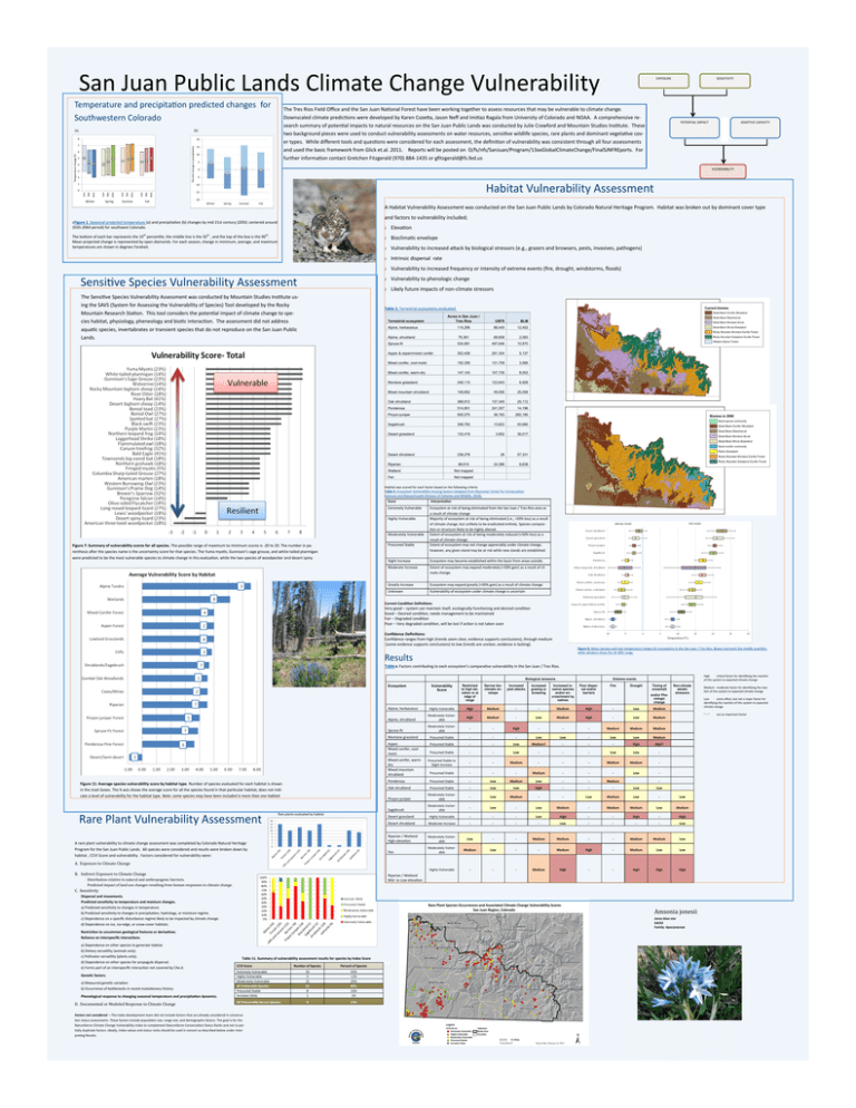
San Juan Public Lands Climate Change Vulnerability Temperature and precipitation predicted changes for Southwestern Colorado (a) 20 Percent change in precipitation 7 6 Temperature change (F) The Tres Rios Field Office and the San Juan National Forest have been working together to assess resources that may be vulnerable to climate change. Downscaled climate predictions were developed by Karen Cozetta, Jason Neff and Imitiaz Ragala from University of Colorado and NOAA. A comprehensive research summary of potential impacts to natural resources on the San Juan Public Lands was conducted by Julie Crawford and Mountain Studies Institute. These two background pieces were used to conduct vulnerability assessments on water resources, sensitive wildlife species, rare plants and dominant vegetative cover types. While different tools and questions were considered for each assessment, the definition of vulnerability was consistent through all four assessments and used the basic framework from Glick et.al. 2011. Reports will be posted on O/fs/nfs/SanJuan/Program/13xxGlobalClimateChange/FinalSJNFREports. For further information contact Gretchen Fitzgerald (970) 884-1435 or gfitzgerald@fs.fed.us (b) 8 5 4 3 2 1 15 10 5 max avg Summer min max avg Spring min max avg min max avg min Winter Fall SENSITIVITY POTENTIAL IMPACT ADAPTIVE CAPACITY VULNERABILITY 0 -5 Habitat Vulnerability Assessment -10 0 EXPOSURE -15 -20 Winter Spring Summer Fall A Habitat Vulnerability Assessment was conducted on the San Juan Public Lands by Colorado Natural Heritage Program. Habitat was broken out by dominant cover type and factors to vulnerability included; cFigure 1. Seasonal projected temperature (a) and precipitation (b) changes by mid 21st century (2050; centered around 2035-2064 period) for southwest Colorado. The bottom of each bar represents the 10th percentile, the middle line is the 50th , and the top of the box is the 90th. Mean projected change is represented by open diamonds. For each season, change in minimum, average, and maximum temperatures are shown in degrees Faraheit. Sensitive Species Vulnerability Assessment The Sensitive Species Vulnerability Assessment was conducted by Mountain Studies Institute using the SAVS (System for Assessing the Vulnerability of Species) Tool developed by the Rocky Mountain Research Station. This tool considers the potential impact of climate change to species habitat, physiology, pheneology and biotic interaction. The assessment did not address aquatic species, invertabrates or transient species that do not reproduce on the San Juan Public Lands. Elevation Bioclimatic envelope Vulnerability to increased attack by biological stressors (e.g., grazers and browsers, pests, invasives, pathogens) Intrinsic dispersal rate Vulnerability to increased frequency or intensity of extreme events (fire, drought, windstorms, floods) Vulnerability to phenologic change Likely future impacts of non-climate stressors Table 3. Terrestrial ecosystems evaluated. Acres in San Juan / Tres Rios USFS BLM Alpine, herbaceous 114,296 88,445 12,402 Alpine, shrubland 76,361 68,808 2,063 Spruce-fir 534,681 497,646 10,970 Aspen & aspen/mixed conifer 352,408 291,304 5,137 Mixed conifer, cool-moist 152,359 131,759 3,566 Mixed conifer, warm-dry 147,143 107,735 8,053 Montane grassland 246,110 123,643 6,928 Mixed mountain shrubland 108,852 49,556 25,058 Oak shrubland 368,912 137,345 25,112 Ponderosa 514,851 241,307 14,196 Pinyon-juniper 930,075 36,193 282,190 Sagebrush 308,793 13,823 93,690 Desert grassland 133,419 3,852 36,017 Desert shrubland 238,278 26 57,331 Riparian 88,610 24,388 8,638 Wetland Not mapped Fen Not mapped Terrestrial ecosystem Habitat was scored for each factor based on the following criteria Table 4. Ecosystem Vulnerability Scoring System (adapted from Manomet Center for Conservation Sciences and Massachusetts Division of Fisheries and Wildlife, 2010). Score Interpretation Extremely Vulnerable Ecosystem at risk of being eliminated from the San Juan / Tres Rios area as a result of climate change Majority of ecosystem at risk of being eliminated (i.e., >50% loss) as a result of climate change, but unlikely to be eradicated entirely. Species composition or structure likely to be highly altered. Extent of ecosystem at risk of being moderately reduced (<50% loss) as a result of climate change. Extent of ecosystem may not change appreciably under climate change, however, any given stand may be at risk while new stands are established. Highly Vulnerable Moderately Vulnerable Presumed Stable Figure 7: Summary of vulnerability scores for all species. The possible range of maximum to minimum scores is -20 to 20. The number in parenthesis after the species name is the uncertainty score for that species. The Yuma myotis, Gunnison’s sage grouse, and white-tailed ptarmigan were predicted to be the most vulnerable species to climate change in this evaluation, while the two species of woodpecker and desert spiny Slight Increase Ecosystem may become established within the basin from areas outside. Moderate Increase Extent of ecosystem may expand moderately (<50% gain) as a result of climate change. Greatly Increase Ecosystem may expand greatly (>50% gain) as a result of climate change. Unknown Vulnerability of ecosystem under climate change is uncertain Current Condition Definitions: Very good – system can maintain itself, ecologically functioning and desired condition Good – Desired condition, needs management to be maintained Fair – Degraded condition Poor – Very degraded condition, will be lost if action is not taken soon Confidence Definitions: Confidence ranges from high (trends seem clear, evidence supports conclusions), through medium (some evidence supports conclusions) to low (trends are unclear, evidence is lacking). Figure 8. Mean January and July temperature ranges for ecosystems in the San Juan / Tres Rios. Boxes represent the middle quartiles, while whiskers show the 10-90% range. Results Table 6. Factors contributing to each ecosystem’s comparative vulnerability in the San Juan / Tres Rios. Biological stressors Restricted to high elevation or at edge of range Narrow bioclimatic envelope Increased invasive species and/or encroachment by natives Poor dispersal and/or barriers Highly Vulnerable High Medium - - Medium High - Low Medium Alpine, shrubland Moderately Vulnerable High Medium - Low Medium High - Low Medium Spruce-fir Moderately Vulnerable - - High - - - Medium Medium Medium Montane grassland Presumed Stable - - - Low Low - Low Low Medium Aspen Mixed conifer, coolmoist Presumed Stable - - Low Medium? - - - High High? Presumed Stable - - Low - - - Low Low - Presumed Stable to Slight Increase - - Medium - - - Medium Medium - Presumed Stable - - - Medium - - - Low - Ponderosa Presumed Stable - Low Medium Low - - Medium Oak shrubland Presumed Stable - Low Low High - - - Low Low Pinyon-juniper Moderately Vulnerable - Low Medium - - Low Medium Low - Low Sagebrush Moderately Vulnerable - Low - Low Medium - Medium Medium Low Medium Desert grassland Highly Vulnerable - - - Low High - - High - High Desert shrubland Moderate Increase - - - - Low - - - - Low Riparian / Wetland High-elevation Moderately Vulnerable Low - - Medium Medium - - Medium Medium Low Fen Moderately Vulnerable Medium Low - - Medium High - Medium Low Low Highly Vulnerable - - - Medium High - - High High High Ecosystem Alpine, herbaceous Mixed conifer, warmdry Mixed mountain shrubland Figure 11: Average species vulnerability score by habitat type. Number of species evaluated for each habitat is shown in the inset boxes. The X-axis shows the average score for all the species found in that particular habitat; does not indicate a level of vulnerability for the habitat type. Note: some species may have been included in more than one habitat Rare Plant Vulnerability Assessment Rare plants evaluated by habitat A rare plant vulnerability to climate change assessment was completed by Colorado Natural Heritage Program for the San Juan Public Lands. 60 species were considered and results were broken down by habitat , CCVI Score and vulnerability. Factors considered for vulnerability were: Vulnerability Score Increased pest attacks Increased grazing or browsing High critical factor for identifying the reaction of this system to expected climate change Extreme events Fire Drought Timing of snowmelt and/or Phenologic change Non-climate abiotic stressors Low some effect, but not a major factor for identifying the reaction of this system to expected climate change “–“ - A. Exposure to Climate Change B. Indirect Exposure to Climate Change Riparian / Wetland Mid- to Low-elevation Distribution relative to natural and anthropogenic barriers. Predicted impact of land use changes resulting from human responses to climate change. C. Sensitivity Dispersal and movements. Predicted sensitivity to temperature and moisture changes. a) Predicted sensitivity to changes in temperature. b) Predicted sensitivity to changes in precipitation, hydrology, or moisture regime. c) Dependence on a specific disturbance regime likely to be impacted by climate change. d) Dependence on ice, ice-edge, or snow-cover habitats. Amsonia jonesii Jones blue star G4/S2 Family: Apocynaceae Restriction to uncommon geological features or derivatives. Reliance on interspecific interactions. a) Dependence on other species to generate habitat. b) Dietary versatility (animals only). c) Pollinator versatility (plants only). d) Dependence on other species for propagule dispersal. e) Forms part of an interspecific interaction not covered by C4a-d. Genetic factors. a) Measured genetic variation. b) Occurrence of bottlenecks in recent evolutionary history. Phenological response to changing seasonal temperature and precipitation dynamics. D. Documented or Modeled Response to Climate Change Table 11. Summary of vulnerability assessment results for species by Index Score CCVI Score Number of Species Percent of Species Extremely Vulnerable Highly Vulnerable Moderately Vulnerable All Vulnerable Species Presumed Stable Increase Likely 33 3 15 51 8 1 55% <1% 25% 85% 13% 1% All Presumably Secure Species 9 15% Factors not considered —The Index development team did not include factors that are already considered in conservation status assessments. These factors include population size, range size, and demographic factors. The goal is for the NatureServe Climate Change Vulnerability Index to complement NatureServe Conservation Status Ranks and not to partially duplicate factors. Ideally, Index values and status ranks should be used in concert as described below under Interpreting Results. 85% Medium moderate factor for identifying the reaction of this system to expected climate change not an important factor

