52. Long Canyon (Keeler-Wolf 1990b) Location
advertisement

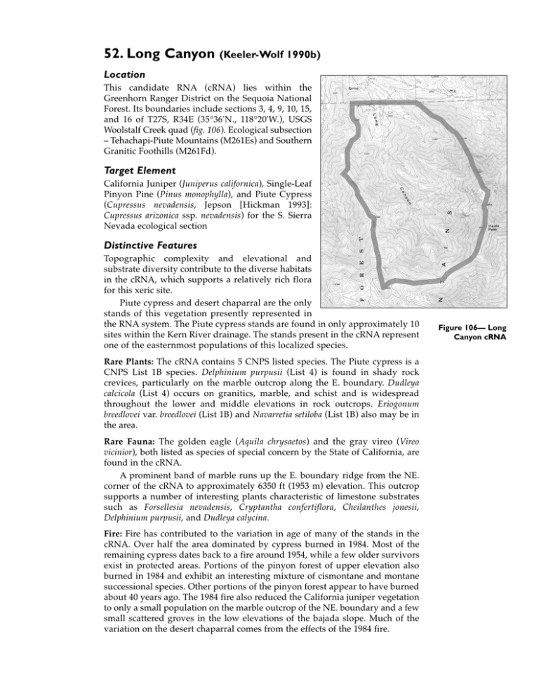
52. Long Canyon (Keeler-Wolf 1990b) Location This candidate RNA (cRNA) lies within the Greenhorn Ranger District on the Sequoia National Forest. Its boundaries include sections 3, 4, 9, 10, 15, and 16 of T27S, R34E (35°36'N., 118°20'W.), USGS Woolstalf Creek quad (fig. 106). Ecological subsection – Tehachapi-Piute Mountains (M261Es) and Southern Granitic Foothills (M261Fd). Target Element California Juniper (Juniperus californica), Single-Leaf Pinyon Pine (Pinus monophylla), and Piute Cypress (Cupressus nevadensis, Jepson [Hickman 1993]: Cupressus arizonica ssp. nevadensis) for the S. Sierra Nevada ecological section Distinctive Features Topographic complexity and elevational and substrate diversity contribute to the diverse habitats in the cRNA, which supports a relatively rich flora for this xeric site. Piute cypress and desert chaparral are the only stands of this vegetation presently represented in the RNA system. The Piute cypress stands are found in only approximately 10 sites within the Kern River drainage. The stands present in the cRNA represent one of the easternmost populations of this localized species. Rare Plants: The cRNA contains 5 CNPS listed species. The Piute cypress is a CNPS List 1B species. Delphinium purpusii (List 4) is found in shady rock crevices, particularly on the marble outcrop along the E. boundary. Dudleya calcicola (List 4) occurs on granitics, marble, and schist and is widespread throughout the lower and middle elevations in rock outcrops. Eriogonum breedlovei var. breedlovei (List 1B) and Navarretia setiloba (List 1B) also may be in the area. Rare Fauna: The golden eagle (Aquila chrysaetos) and the gray vireo (Vireo vicinior), both listed as species of special concern by the State of California, are found in the cRNA. A prominent band of marble runs up the E. boundary ridge from the NE. corner of the cRNA to approximately 6350 ft (1953 m) elevation. This outcrop supports a number of interesting plants characteristic of limestone substrates such as Forsellesia nevadensis, Cryptantha confertiflora, Cheilanthes jonesii, Delphinium purpusii, and Dudleya calycina. Fire: Fire has contributed to the variation in age of many of the stands in the cRNA. Over half the area dominated by cypress burned in 1984. Most of the remaining cypress dates back to a fire around 1954, while a few older survivors exist in protected areas. Portions of the pinyon forest of upper elevation also burned in 1984 and exhibit an interesting mixture of cismontane and montane successional species. Other portions of the pinyon forest appear to have burned about 40 years ago. The 1984 fire also reduced the California juniper vegetation to only a small population on the marble outcrop of the NE. boundary and a few small scattered groves in the low elevations of the bajada slope. Much of the variation on the desert chaparral comes from the effects of the 1984 fire. Figure 106— Long Canyon cRNA Physical Characteristics The area covers 2389 acres (967 ha) with an elevation range of 3550-6901 ft (10822103 m). The cRNA lies at the NE. end of the Piute Mountains and is highly varied topographically and geologically. It is a dry area with substantial desert influence, exhibiting a rapid W.-to-E. gradation from cismontane to desert vegetation. The cRNA is geologically diverse, dominated by pre-Cenzoic metasedimentary rocks including schists, phyllite, and marbles in the N. and W. parts. Mesozoic granitic (part of the Sierra Nevada Batholith) rock dominates on the SW. and E. parts. The soils of the cRNA are broken down into three main complexes. The Livermore family – Rock outcrop complex is the most extensive; it is a dark brown, cobbly, and stony sandy loam about 18 inches (46 cm) thick. The next most extensive soil is the Rock outcrop – Tollhouse complex, which is a shallow (17 inches [43cm]), brown, coarse, sandy loam over highly weathered granitic rock. The final soil type is the Xerofluvents – Xerothents association. Soils of this group are deep, gravelly, cobbly, and stony sandy loam and sandy loam occurring on the bajada slope at the N. end of the RNA. Rock outcrops also exist on the NE. boundary (marble outcrop). No weather stations exist within the cRNA. The Piutes rise abruptly from the Kern River valley, and, consequently, temperature and precipitation change rapidly with elevation in the cRNA. The area falls between a Mediterranean climate and a steppe climate. The closest climate data are from Wofford Heights, approximately 9 miles (14.5 km) NW. of the SW. edge of the cRNA, and at an elevation of 2625 ft (800 m), which is about 2575 ft (785 m) lower than the cRNA. It is likely that precipitation for the upper elevations in the cRNA averages about 16 inches (406 mm) per year, while the lowest elevations average about 8 inches (203 mm) per year. No temperature data are available. It is estimated that the frost-free period ranges from 240 days at lower elevations to 180 days at upper elevations. There are probably 30-90 days when the maximum temperature exceeds 90 °F (32 °C). Association Types Desert Chaparral (37400): 1042 acres (422 ha). Desert chaparral vegetation contains a mixture of cismontane chaparral shrubs and cool or hot desert species; it is the most widespread vegetation type in the cRNA. It exhibits great variation, not only in successional state, but also as a result of slope exposure, elevation, and geological substrate. Its distribution ranges from 3550 ft (1082 m) along the arroyo banks on the N. boundary to 6800 ft (2073 m) near the summit of Heald Peak. The densest and most extensive stands occur on N.-facing slopes and are dominated by species such as Ceanothus greggi ssp. vestitus, Fremontodendron californicum, and Arctostaphylos glauca. High-elevation ridge-crest stands on granitic soil may be dominated by Artemisia tridentata, Ephedra viridis, and others. S.-slope dominants include California juniper, Yucca whipplei, Happlopappus linearifolius, Eriogonum fasciculatum, and Encelia virginiensis. Low-elevation, gently sloping sites have mixtures of species such as foothill pine (Pinus sabiniana) and scrub interior live oak (Quercus wislizenii var. fructescens) with xerophytic species such as Senecio douglasii and Chrysothmanus nausiosus. Cover is usually less than 50 percent. Common understory species include: Lomatium dissectum, Melica stricta, Delphinium purpusii, Balsamorhiza deltoidea, Arenaria macradenia var. arcuifolia, Castilleja jepsonii, Galium hallii, Erysimum moniliforme, Claytonia spathulata, and Gilia interior. Many of the recently burned stands also contain numerous post-fire herbaceous species such as Turricula parryi, Malacothamnus orbiculatus, Eriophyllum confertiflorum, and Haplopappus arborescens. Pinyon Forest (72210): 525 acres (213 ha). This association occupies the higher elevation, N.-facing slopes (fig. 107). It also occurs sporadically in sheltered canyons. It is dominated by single-leaf pinyon pine (occurring almost exclusively at the higher elevations) and codominates with canyon live oak (Quercus chrysolepis) and foothill pine at lower elevations. At the highest elevations, pinyon has an average density of 235 trees/acre (580 trees/ha); most of the trees here appear to be less than 200 years old. Sapling and seedling density is low (12/acre [30/ha]). Understory cover is low with Ribes velutinum var. glanduliferum, Ephedra viridis, Galium munzii, and Phlox diffusasubcarinata being most common. At lower elevations, trees are smaller, and seedlings and saplings of pinyon are more common. The understory is more developed and includes Balsamorhiza deltoidea, Symphoricarpos parishii, Galium munzii, Poa scabrella, Lomatium dissectum, Ribes roezlii, Erigeron foliosus, and Galium aparine. At the S. end of the cRNA, a pinyon forest with canyon live oak, shin oak (Quercus garryana var. breweri), and California black oak (Quercus kelloggii) occurs. The burned portion of the pinyon forest on the NW.-facing slope of Heald Peak contains no pinyon seedlings or saplings and an uncharacteristic assemblage of herbs such as Phacelia fremontii, Eroiphylum abiguum, Phacelia egena, and Layia glandulosa. Annual Grassland (42200): 492 acres (199 ha). This association type occupies xeric, S.-facing slopes up to 5600 ft (1701 m). The substrate is generally rocky and not very deep. The most widespread dominant species are Avena fatua, Bromus rubens, and B. tectorum. Several native Figure 107—Long Canyon, view of west-facing pinyon pine forest on upper slopes of Heald Peak in Long Canyon cRNA. (1989) perennial grasses also occur scattered. They are Sitanion hystrix, Poa scabrella, Stipa coronata, and Melica imperfecta. Woody perennial species occurring include Yucca whipplei ssp. caespitosa, Ephedra viridis, Eriogonum fasiculatum, Fremontodendron californicum, Ceanothus greggi ssp. vestitus, Keckliella breviflorus, Mimulus longliflorus ssp. calycinnus, Encelia virginianus, Lotus scoparius, and Eriophyllum confertiflorum. The annual grassland at the lowest elevations, on the bajada in the N. portion of the cRNA, receives heavier grazing. Here, soil is deep and porous and precipitation is low. Annuals, including Bromus rubens and Erodium cicutarium, predominate. The annual grassland has a varied fire history that has created patchy abundance of certain species, such as Yucca whipplei, Lotus grandiflorus, and Calystegia longipes. Foothill Pine Woodland (71300): 115 acres (47 ha). This association is found on the alluvial deposits of the bajada slope at the mouth of Long Canyon and is a mixture of cismontane and transmontane species. The dominate foothill pines are relatively small – average height is about 20 ft (6 m) – and young, appearing to have burned within the past 35-40 years. The canopy is open, with 10-30 percent cover. The shrub cover is dominated by California juniper, Ceanothus leucodermis, C. greggii ssp. vestitus, and Fremontodendron californicum. The understory averages about 60 percent cover and includes Haplopappus linearifolius, Lepidospartum squamatum, Artemisia tridentata, Eriogonum fasciculatum ssp. poliofolium, Chrysothamnus nausiosus, and Sencio douglasii. Most of the tree overstory in this association type appears to have been destroyed by the 1984 fire. Shin Oak Brush (37541): 89 acres (56 ha). Shin oak dominates a small area of high elevation, NW.-facing granitic slopes. It is a clonal resprouter and tends to occur in large, dense patches. In addition to the dominant shin oak, Garrya flavescens ssp. pallida, Ceanothus greggii ssp. vestitus, and Fremontodendron californicum also are found in the canopy layer. The understory includes Symphoricarpos parishii, Solanum xantii, and Ribes roezlii. Annual and perennial herbs include Phacelia mohavensis, P. davidsonii, Mimulus fremontii, Senecio breweri, and Zigadenus exalticus. The majority of the shin oak was burned in the 1984 fire. Jeffrey Pine Forest (85100): 55 acres (22 ha). This association type is restricted to two stands, one recently burned and one unburned. Both stands occupy N.facing exposures on granitic soils. The larger stand suffered a crown fire in 1984 that killed all the trees. This stand currently supports low resprouts (3 ft [1 m]) of Jeffrey pine (Pinus jeffreyi), California black oak, and canyon oak. The understory is dominated by resprouts of shin oak and Symphoricarpos parishii along with Solanum xantii seedlings. The herbaceous vegetation is well developed and includes Lupinus albicaulis var. shastensis, Silene verecunda ssp. platyota, Lithophragma parviflora, Cystopteris fragilis, and Arabis repanda. The unburned stand is bordered by pinyon forest and shin oak brush and occupies a rockier substrate. Dominants average 50-60 ft (15-18 m) tall, 2-2.5 ft (60-75 cm) dbh, and 200 years old. The understory is relatively open and includes saplings and pole size Jeffrey pines, along with Artemisia tridentata, Chrysothamnus viscidiflorus, Ceanothus greggii ssp. vestitus, shin oak, and Symphoricarpos parishii. Limestone Outcrop (No Holland equivalent): 22 acres (9 ha). This marble outcrop forms the NE. boundary and supports a unique assemblage of plants. Average vegetation cover is about 5-15 percent. Dominant species include California juniper, Ephedra viridis, Yucca whipplei ssp. caespitosa, Salvia dorrii, Stipa speciosa, Selaginella asprella, Salvia colubarae, and Eriogonum saxatile. At higher elevations the unusual desert shrub Forsellesia nevadensis becomes common. Piute Cypress Forest (83330): 20 acres (8 ha). This association type is made up of two stands occupying slopes ranging from due N. to due E. The stands are underlain by schistose metamorphics and separated by a SE.-facing band of annual grassland. The majority of the N. stand burned in 1984, while the smaller S. stand was last burned in the late 1940s. Cypress seedlings were present on all plots and ranged from densities of 7-73 seedlings/100-m2 plot. In addition to the cypress, 30 species of plants were noted on the burned plots. Ceanothus greggii ssp. vestitus seedlings and resprouts of Fremontodendron californicum were the most common. Total ground cover on the burned plots ranged from 30 to 60 percent. The trees in the unburned stand vary in size from broad and tall at lower elevations, to stunted at higher elevations. Cone size varies also and is directly correlated with the size of the tree. Tree density on the unburned plots was 6-61 trees/100 m2, and tree size was 1-2 inches (2.5-5 cm) dbh, 8-10 ft (2.5-3 m) tall. The understory is composed of only half the species (15) as in the burned stand; it is dominated by Ceanothus greggii ssp. vestitus. California Juniper Scrub (72400): 12 acres (5 ha). The 1984 fire destroyed many of the best stands of California juniper in the cRNA. Before the fire, juniper ranged up to the summit of the W. ridge and throughout the desert chaparral and annual grassland. The only area where extensive California juniper remains is along the marble outcrop (cover between 10-30 percent). It is also found scattered at lower elevations on the bajada slope near the N. boundary and along the W. boundary ridge. The most common understory species are Stipa speciosa, Yucca whipplei ssp. caespitosa, and Haplopappus linearifolius. White Alder Riparian Forest (61510): 15 acres (6 ha). This association is restricted to narrow strips of permanently moist areas along the Long Canyon streambed. The white alders (Alnus rhombifolia) are small (not more than 20 ft [6 m] tall) and short lived due to fluctuating water availability. Associated species include Salix lasiolepis var. bracelinae, Populus fremontii, Ribes nevadense, Mimulus guttatus, M. cardinalis, Nasturtum officinale, Juncus xiphioides, and J. macrophllus. This association also was affected by the 1984 fire, which killed several patches of white alder in the lower and middle sections of the stream channel. Plant Diversity Two hundred forty-five species of vascular plants are listed. Conflicting Impacts Despite proximity to human development, the cRNA has experienced little impact. One dirt road enters the cRNA in the N. region. A few campsites and a cluster of old bee boxes (no longer in use) are associated with the road. The westernmost branch of the road ends at a mining excavation in metamorphic rock, but appears not to be in use. Dirt bikes and other off-highway vehicles appear to have used the road and the main trail. Cattle grazing is limited to the annual grassland with little or no impact on the shrubs of the adjacent foothill pine woodland or the vegetation along the streambed. The few cattle seen were near the N. boundary where a fence delineates the RNA. However, the current condition of the fence allows the cattle to easily cross.


