18. Cleghorn Canyon (White 1994) Location
advertisement

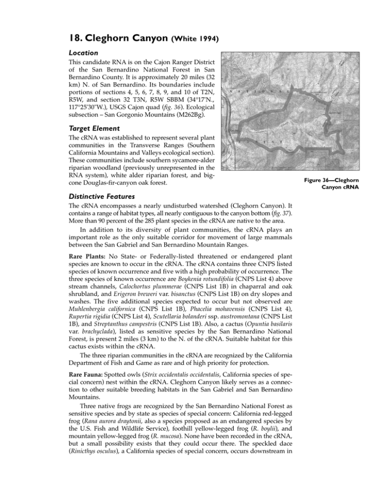
18. Cleghorn Canyon (White 1994) Location This candidate RNA is on the Cajon Ranger District of the San Bernardino National Forest in San Bernardino County. It is approximately 20 miles (32 km) N. of San Bernardino. Its boundaries include portions of sections 4, 5, 6, 7, 8, 9, and 10 of T2N, R5W, and section 32 T3N, R5W SBBM (34°17'N., 117°25'30"W.), USGS Cajon quad (fig. 36). Ecological subsection – San Gorgonio Mountains (M262Bg). Target Element The cRNA was established to represent several plant communities in the Transverse Ranges (Southern California Mountains and Valleys ecological section). These communities include southern sycamore-alder riparian woodland (previously unrepresented in the RNA system), white alder riparian forest, and bigcone Douglas-fir-canyon oak forest. Distinctive Features The cRNA encompasses a nearly undisturbed watershed (Cleghorn Canyon). It contains a range of habitat types, all nearly contiguous to the canyon bottom (fig. 37). More than 90 percent of the 285 plant species in the cRNA are native to the area. In addition to its diversity of plant communities, the cRNA plays an important role as the only suitable corridor for movement of large mammals between the San Gabriel and San Bernardino Mountain Ranges. Rare Plants: No State- or Federally-listed threatened or endangered plant species are known to occur in the cRNA. The cRNA contains three CNPS listed species of known occurrence and five with a high probability of occurrence. The three species of known occurrence are Boykenia rotundifolia (CNPS List 4) above stream channels, Calochortus plummerae (CNPS List 1B) in chaparral and oak shrubland, and Erigeron breweri var. bisanctus (CNPS List 1B) on dry slopes and washes. The five additional species expected to occur but not observed are Muhlenbergia californica (CNPS List 1B), Phacelia mohavensis (CNPS List 4), Rupertia rigidia (CNPS List 4), Scutellaria bolanderi ssp. austromontana (CNPS List 1B), and Streptanthus campestris (CNPS List 1B). Also, a cactus (Opuntia basilaris var. brachyclada), listed as sensitive species by the San Bernardino National Forest, is present 2 miles (3 km) to the N. of the cRNA. Suitable habitat for this cactus exists within the cRNA. The three riparian communities in the cRNA are recognized by the California Department of Fish and Game as rare and of high priority for protection. Rare Fauna: Spotted owls (Strix occidentalis occidentalis, California species of special concern) nest within the cRNA. Cleghorn Canyon likely serves as a connection to other suitable breeding habitats in the San Gabriel and San Bernardino Mountains. Three native frogs are recognized by the San Bernardino National Forest as sensitive species and by state as species of special concern: California red-legged frog (Rana aurora draytonii, also a species proposed as an endangered species by the U.S. Fish and Wildlife Service), foothill yellow-legged frog (R. boylii), and mountain yellow-legged frog (R. mucosa). None have been recorded in the cRNA, but a small possibility exists that they could occur there. The speckled dace (Rinicthys osculus), a California species of special concern, occurs downstream in Figure 36—Cleghorn Canyon cRNA Cajon Wash, but it is predicted to seek refuge in Cleghorn Wash during high sediment loads. The San Diego horned lizard (Phrynosoma coronatum blainvillei) and the coast patch-nosed snake (Salvadora hexalepis virgultea), both listed as California species of special concern, occur in the cRNA. Several California species of special concern and Forest Service-listed sensitive bird species nest in or migrate through the cRNA. These include Wilson’s warbler (Wilsinia pusilla), purple martin (Pogne subis), yellow warbler (Dendroica petechia brewsteri), Cooper’s hawk (Accipiter cooperi), sharp-skinned hawk (Accipiter striatus), and golden eagle (Aquilia chrysaetos). Although not observed within the cRNA, the prairie falcon (Falco peregrinus anatum) and least Bell’s vireo (Vireo bellii pusillus), both State- and Federally-listed as endangered, are known to nest near Cleghorn Canyon. Four mammals listed as San Bernardino National Forest management special emphasis species occur in the cRNA: mountain lion (Felis concolor), mule deer (Odocoileus hemionus), western gray squirrel (Sciurus griseus), and black bear (Ursus americanus). Fire History: Major fires in the watershed occurred in 1921 and 1964. Cultural: A long-abandoned homesite with a cabin and a few pieces of concrete foundations can be found near the canyon floor. Remains of the foundations of several structures are found further upstream; the cabins probably washed away in the 1930s or 1940s. Physical Characteristics The area covers 1880 acres (761 ha) at an elevation of 2900-5300 ft (884-1615 m). The cRNA is on the W. slope of the San Bernardino Mountains and encompasses most of the Cleghorn watershed, the boundaries of which correspond to the cRNA boundaries. The San Gabriel Mountains lie to the W., and the Mojave Desert lies N. of the cRNA. A few miles S. is the urbanized San Bernardino Valley, an E. extension of the Los Angeles basin. Topography of the cRNA is dominated by steep mountain sides facing N. and S., divided by Cleghorn Creek and its tributaries, trending from E. to W. Vegetation varies greatly as one progresses down the slope. Almost all bedrock in the cRNA is metamorphic (quartz diorite gneiss). Other areas are mapped as granodiorite, fanglomerate, "Crowder formation" sandstone and gravel, and surface gravel. Two fault lines cross the cRNA. Soils are predominantly shallow and rocky with little horizon development and are dry throughout the profile for much of the year. Most are entisols in the Xerothent great group. Other soils are from the Xerosamment and Xerofluvent great groups. The cRNA has a Mediterranean type climate characterized by hot, dry summers and mild, rainy winters. Most precipitation falls as rain or snow (upper elevations) during the winter and spring months. Thunderstorms bring some summer precipitation. No permanent weather stations exist in the cRNA. Average annual precipitation is estimated between 34 and 41 inches (865-1043 mm), based on climate data of Lake Arrowhead (11 miles [18 km] E. with an elevation comparable to the cRNA’s highest areas) and Lytle Creek Ranger Station (4 miles [6 km] SW. with an elevation comparable to the lowest point of the cRNA). Temperature at the cRNA is estimated to be 5 °F (summer) to 9 °F (winter) (3-5 °C) warmer than at Lake Arrowhead, where the average annual temperature is 51 °F (11 °C), average July temperature is 69 °F (21 °C), and average January temperature is 37 °F (3 °C). Fog often covers lower Cleghorn Canyon in spring and early summer; it may be responsible for Cleghorn Canyon’s moderate temperatures and distinctly cismontane character even though it is near the Mojave Desert. Cajon Pass, approximately 3 miles (1.9 km) NW. of the cRNA, is one of the major funnel areas for Santa Ana winds, which increases the risk of wildfire spreading into the cRNA. Association Types Canyon Oak Forest-Bigcone Douglas-Fir (84150): This association is the dominant forest type in the cRNA. It occurs on N.- and E.-facing slopes above about 3800 ft (1158 m), and in steep, N.-facing drainages nearly to the canyon floor. The trees occur in both young and mature stands. The younger stands contain small canyon oak (Quercus chrysolepis), incense-cedar (Libocedrus decurrens), and a few bigcone Douglas-fir (Pseudotsuga macrocarpa). The understory is sparse and contains scattered plants of Toxicodendron diversilobum, Ribes roezlii, Bromus tectorum, B. diandrus, Agoseris sp., Elymus sp., and various tree seedlings. There appear to be no bigcone Douglas-fir trees that predate the most recent fire. The more mature stand is composed of canyon oak and bigcone Douglas-fir in many size classes up to 30 inches (80 cm) dbh. Incense-cedar and bigleaf maple (Acer macrophyllum) (along the stream channel) also occur in the canopy. Understory resembles that of the younger stands. Canyon Live Oak-Deerbrush Shrub Land (37530 in part): This association type develops after fire in the bigcone Douglas-fir-canyon oak forest. Dead deerbrush (Ceanothus integerrimus) stems are common. A few fire-scarred bigcone Douglasfir trees live in the area and have begun reproducing. Interior Live Oak-Chaparral Whitethorn Shrub Land (37A00 in part): This association type occurs in scattered patches within larger stands of chaparral or canyon oak forest and shrub land in the cRNA. It is usually found on S.-facing slopes and on E.- or W.-facing slopes of minor ridgelines. This shrub land can potentially develop into interior live oak forest (Quercus wislizenii), but no significant stands of interior live oak forest exist on the cRNA. The composition, structure, and development are similar to those of the montane Ceanothus chaparral and the bigcone Douglas-fircanyon oak forest, except that interior live oak and chaparral whitethorn (Ceanothus leucodermis) replace canyon oak and deerbrush. Additional species include Rhus trilobata, Bromus tectorum, and Prunus ilicifolia. Chamise-Eastwood Manzanita Chaparral (37110 in part): This association type is common on S.-facing sites above about 4000 ft (1219 m), often intermixed with interior live oak chaparral. Vegetation generally has a dense cover less than 6 ft (2 m) high. The dominant species are chamise (Adenostoma fasciculatum) and eastwood manzanita (Arctostaphylos glandulosa). The only other species is chaparral whitethorn. Figure 37— Cleghorn Canyon, view west from Cleghorn Pass, elevation 4545 ft (1385 m). (1993) Chamise-Hoaryleaf Ceanothus Chaparral (37120/37200): This association type is common on S.-facing slopes in the cRNA below about 4500 ft (1372 m). The vegetation is dense (66-96 percent cover) and relatively tall (20 percent over 6 ft [2 m]). Chamise and hoaryleaf Ceanothus (C. crassifolius) are the dominant species, but other species such as scrub oak (Quercus berberidifolia), chaparral whitethorn, mountain mahogany (Cercocarpus betuloides), Mexican elderberry (Sambucus mexicanus), bigberry manzanita (Arctostaphylos glauca), and interior live oak may occur as dominants in different areas. Additional shrubs common in this association type include California coffeeberry (Rhamnus californica), hollyleaf redberry (Rhamnus ilicifolia), toyon (Heteromeles arbutifolia), hollyleaf cherry (Prunus ilicifolia), flannel bush (Fremontodendron californicum), and eastwood manzanita (Arctostaphylos glandulosa). Mountain Mahogany Chaparral (37400/37110): This association type is abundant on the steepest S.-facing slopes in the cRNA. Mountain mahogany is the dominant species. Other regularly occurring species include chamise, bush monkeyflower (Mimulus aurantiacus), and giant stipa (Achnatherum coronatum). Scrub Oak Chaparral (37900): This association occurs in a belt near the canyon bottom, mostly on the N.-facing side of the canyon below about 4000 ft (1219 m). Scrub oak (Quercus berberidifolia) occurs with many other species including chamise, chaparral whitethorn, eastwood manzanita, bigberry manzanita, toyon, and hollyleaf cherry. Non-Native Grassland (42200): A section of non-native grassland is present in the far W. corner of the cRNA. Dominant species are Bromus tectorum, B. diandrus, and Avena barbata. The only native plants with high cover are yerba santa (Eriodictyon trichocalyx), chamise, and deerweed (Lotus scoparius). Other native shrubs and herbs include Galium angustifolium, Ericameria linearifolia, E. pinifolia, Salvia apiana, Yucca whipplei, and Eriogonum fasciculatum. The area was probably covered by chamise chaparral previously but has been converted to non-native grassland by frequent fire. Riparian Mosaic (63320/61510/62400): Riparian vegetation occurs in a strip along Cleghorn Creek and falls into the three Holland classifications listed above. The three types occur in small stands, often intergrading into one another in a mosaic pattern. The mosaic pattern is likely a result of dynamic sediment deposition and scouring as flooding and bed alterations redirect stream flows. Southern Willow Scrub (63320): is located in a small, intermittent drainage on an old bench above the canyon floor. It is atypical in the riparian sites of the cRNA. It is dominated by arroyo willow (Salix lasiolepis) and mugwort (Artemisia douglasiana). Vertical structure is dense, and overall height exceeds 9 ft (3 m) but does not approach heights of riparian trees. Additional species include deerweed, Mexican elderberry, cottonwood (Poplus fremontii), Galium sp., Salvia mellifera, Solanum xanti, Solidago californica, Toxicodendron diversilobum, Claytonia perfoliata, and Lonicera subspicata. White Alder Riparian Forest (61510): is dominated by white alder (Alnus rhombifolia), present in many size classes and usually forming a nearly closed canopy, with a sparse understory of mulefat (Baccharis salicifolia), mugwort, or willows. Forest heights are well over 9 ft (3 m). Other common species are mountain mahogany, California sycamore (Platanus racemosa), Juncus xiphioides, Muhlenbergia rigens, and Bromus diandrus. Sycamore Alluvial Woodland (62400): has a relatively open canopy (28-44 percent cover above 9 ft [3 m]). California sycamore is nearly the only overstory species and occurs in many size classes. Shrub and understory species are diverse. They include mulefat, willow, mugwort, Datisca glomerata, Eriogonum fasciculatum, Brickellia californica, Epilobium canum, Avena barbata, Bromus diandrus, Lepidospartum squamatum, and Melilotus alba. Plant Diversity Two hundred eighty-five species of vascular plants are listed. Conflicting Impacts Air pollution and smog from the S. California basins reach Cleghorn Canyon and likely have an effect on vegetation (e.g., Miller 1984, Westman 1981). The cRNA is within the Summit grazing allotment, although steep topography and dense vegetation probably prevent cattle from using it. No sign of livestock was observed during the field survey. The canyon also is used for deer and bear hunting. A few roads exist along the boundaries of the cRNA. At the bottom of the canyon, a privately owned site is used for sand and gravel mining. The Southern California Gas natural gas pipeline and a buried PacBell telephone cable pass through the W. edge of the canyon.


