Document 11213994
advertisement

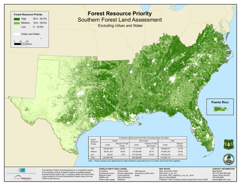
Forest Resource Priority High 39.5 - 94.5% Medium 18.9 - 39.5% Low 0 - 18.9% Forest Resource Priority Southern Forest Land Assessment Excluding Urban and Water Urban and Water 0 50 100 Miles ¯ Puerto Rico 13 Southern States (and Puerto Rico) Excluding Urban and Water Forest Resource Priority High Medium Low Total Forest Acres Non-Forest Percent of Total Forest Acres Total Percent of Total Non-Forest Acres Percent of Total 155,567,904 69.5% 4,117,573 1.4% 159,685,477 31.0% 68,341,243 30.5% 110,526,080 38.1% 178,867,323 34.8% 85,037 0.0% 175,725,335 60.5% 175,810,373 34.2% 223,994,185 290,368,988 514,363,173 Note: Priority classes were determined by Natural Breaks using data from all 13 states and Puerto Rico together. The Southern Forest Land Assessment is a cooperative project of the Southern Group of State Foresters to spatially identify important forest lands in the 13 southern states and Puerto Rico. It was funded by a Forest Stewardship Program grant from the USDA Forest Service. OVERLAY INPUT DATA LAYERS Forestland Forest health Development level Priority watersheds Riparian areas Forest patches Wildfire risk Site productivity Public water supply Wetlands T&E Species Proximity to public land Slope MAP NOTES Date: November 2008 Data layer: p_uw_3c_r File name: SAP_regional_p_uw_3c_r.mxd Map by: Brad Barber Projection: USA Contiguous Albers Equal Area Conic USGS CONTACT INFORMATION Brad Barber SFLA Project Manager Texas Forest Service 979-458-6650 bbarber@tfs.tamu.edu
