Document 11090078
advertisement

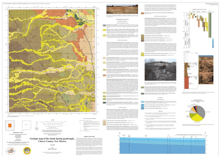
556000 104°22'30"W 557000 558000 3693000 Qoae is comprised of very pale brown (10YR7/4) to reddish brown (5YR4/4), unconsolidated, moderately sorted, coarse- to fine- grained sand, silty sand, silt, and sandy clay. Stage III to III+ pedogenic carbonate. Where gypsiferous, it is white (2.5Y8/1) to light gray (2.5Y7/1) to very pale brown (10YR7/4), unconsolidated, well sorted, fine-grained, gypsiferous sand, silty sand, and sandy clay. 3693000 hmp3 Hmp2 Qlt2 daf daf hmp4 daf daf Qa Qahf3 Qahf3 3691000 Qahf2 Qahf2 Qahf3 Qahc1 Qahf4 Qlt3 Qahf3 Qahc2 Qahf1 daf Qlt3 Qoae Qlt3 Qlt3 daf daf daf 3690000 Qahf4 Qahc2 daf Qahf3 daf Bu ck le Qahf3 Qahf4 daf Qa Qa Qvf daf Qahf4 Qahf3 YO Qahf3 3689000 Qlt1 Qoae daf daf Qa Qlt2 Qahc1 daf Qahf4 Qahf3 Qahf3 3690000 Qlt2 daf daf daf Qahf3 Alluvium and anthropogenic deposits 3691000 Qa Qlt2 Qds Qa hmp3 Hmp2 Qa Qlt3 Qahf2 QUATERNARY/NEOGENE Qabh1 Qabh1 Qoae daf Qabh1 Qabh1 Qoae daf Qahf4 Qa Qahf4 3689000 Qahc2 daf daf daf daf Qlt2 Qahc1 daf Qahf4 daf daf 33°20'N Qahf3 33°20'N daf Qahf1 daf daf daf Qahf4 daf Qahf3 daf daf Qlt3 daf Qahc1 3687000 Qahf3 A Qahc1 Qahf1 Qlt2 Qahf3 daf Qahf2 Qoae Qahf4 daf Qahf3 Qahf2 daf 3687000 daf daf daf Qahf3 daf daf daf Qahc2 Qahf2 daf daf Qahc2 Qahf4 daf daf daf Qlt2 3685000 daf daf Qahf4 Qlt3 Qahf3 daf Qlt2 daf Qlt2 Qahf4 Qahf3 Qahc2 3684000 Qahc1 daf Qahf4 Qahf3 Qabp daf Qahf2 Qahf3 Qahf3 Qahf4 Qahf3 daf daf 33°17'30"N Qd Qa Qahf3 Qahf4 Qahf3 Qahf3 Qa daf daf Qahf3 daf Qahf2 Qahf2 Hmp2 Qlt3 Qahf2 3685000 Qahf4 Qahf4 Qlt3 Qlt2 Qlt2 Qahc2 Qahf3 Qa Qahf4 Qlt2 Qa Qlt2 Qlt3 3684000 Qa Qlt3 Qa Qlt3 Qlt2 Qlt3 Qa Qa daf Qlt3 Qlt3 Qlt3 Qlt3 daf Qlt2 Qa Qlt3 Qa Qlt3 Qahf2 Qahf1 Qvf Qvf Qvf hmp3 Qlt3 Qlt3 daf Qlt3 Qlt3 daf daf 3686000 Qlt3 Qvf Qlt2 Qa Qahf3 Qlt2 Qoae daf Qahf3 daf Qahf1 hmp4 Qlt3 daf daf 1 Bogle Qahc1 daf daf Qahc1 Qlt2 daf daf Qahc1 A' daf daf Qahf2 The modern meanderbelt (hmp4) was mapped from both 2005 digital 1-m resolution, color orthophotography and 1981 color aerial photography, and a 1939-1940 meanderbelt (hmp3) was mapped using vintage U.S.D.A. – Soil Conservation Service black and white aerial photography. All aerial photography was georeferenced and plotted onto the 2005 orthophotography using ArcGIS, to produce a derivative Pecos River channel historical map showing channel migratory change patterns (not included in the open-file report). The historic units are differentiated from the Holocene units by using a lower case “h” on the unit labels. Qahc2 Qahf4 daf Qahc1 daf Qlt2 daf Qahf4 Qahf1 3686000 Qlt1 daf Qahc2 daf daf 3688000 Qoae Qahc1 Qahf2 daf Qahf4 daf Qahc1 Qahf2 3688000 33°17'30"N Qahc2 Qahc2 Qahc2 Qahf3 Qahf3 Qahc2 Qahf2 3683000 daf Qahf3 Qahf4 Qahf1 Qahf2 daf Qahc1 daf daf Qds Qahf1 Qahc1 Qlt3 Qahf3 Qahc1 Qlt3 Qahf3 Qlt3 daf Qds Qlt2 Qlt3 Qd daf Qahf2 Qa 1 Orchard Park daf Qahf2 Qlt3 Qahf1 Qahf2 3680000 Qahf1 Qahf3 Qds Qahf3 Qahf4 Qahf2 Qahc1 Qahf1 Qahf1 daf daf Qahf4 Qahf1 Qahf2 Qahc1 Qahc1 Qahf4 Qahf2 Qahf2 Qahf3 Qahf3 Qahf4 daf daf Qlt1 104°30'W 547000 548000 549000 550000 551000 104°27'30"W 552000 553000 554000 104°25'W 555000 556000 557000 33°15'N 558000 104°22'30"W Base map from U.S. Geological Survey in cooperation with U.S. Corps of Engineers 1950, from photographs taken 1961, revised 1962. 1927 North American datum, UTM projection -- zone 13N 1000-meter Universal Transverse Mercator grid, zone 13 EXPLANATION OF MAP SYMBOLS 1:24,000 1 ROSWELL NORTH BITTER LAKE 0.5 ROSWELL SOUTH PETERS LAKE DEXTER WEST 0 A' 1 MILE COMANCHE SPRING 1000 South SOUTH SPRING Spring A 0 1000 2000 3000 4000 5000 6000 NEW MEXICO 1 BOTTOMLESS LAKES Magnetic Declination April 2007 8º 33' East At Map Center DEXTER EAST QUADRANGLE LOCATION New Mexico Bureau of Geology and Mineral Resources New Mexico Tech 801 Leroy Place Socorro, New Mexico 87801-4796 [505] 835-5490 http://geoinfo.nmt.edu This and other STATEMAP quadrangles are (or soon will be) available for free download in both PDF and ArcGIS formats at: http://geoinfo.nmt.edu/publications/maps/geologic/ofgm/home.html 0.5 0 1 KILOMETER CONTOUR INTERVAL 10 FEET Oldest braided valley-mouth alluvial-fan deposits (upper to middle (?) Pleistocene) — Lowest-lying, yet most extensive braided alluvial-fan deposit. Greatly modified by agriculture on its eastern margin adjacent to and within the Pecos floodplain. Only an occasional channel remnant remains. Overriden by Hmp3. Thickness ~2 to 30 m. Geologic contact. Solid where exposed or known, dashed where approximately known, dotted where concealed or inferred. Qlt2 Young Lakewood terrace alluvial deposits (upper Pleistocene) —Thickness 1.5 to 5 m. Qlt1 Older Lakewood terrace alluvial deposits (upper to middle Pleistocene) —Thickness ~2 to 9 m. Extinct spring due to a lowered water table resulting from groundwater pumping. 1 Bogle Orchard Park terrace alluvial deposits (upper to middle Pleistocene) — According to Fiedler and Nye (1933), the Orchard Park terrace rises 1.5-3 m above the Lakewood terrace and 6-10.5 m above the Pecos floodplain. It consists of interbedded alluvial and eolian deposits and is mapped as an alluvial-eolian complex (Qoae). On the South Spring quad, the Orchard Park terrace is largely buried by the Rio Hondo alluvial fan complex, and is only exposed in the northeast corner. Unlike the majority of Qoae deposits on Younger Quaternary alluvial fan channels (Holocene to upper Pleistocene) — Thickness <1 to 3 m. Qahc1 Older Quaternary alluvial fan channels (upper to middle Pleistocene) — Thickness 1 to 3 m. Qoae Qahf2 Qahc2 Qd Qahf1 W COMMENTS TO MAP USERS A geologic map displays information on the distribution, nature, orientation, and age relationships of rock and deposits and the occurrence of structural features. Geologic and fault contacts are irregular surfaces that form boundaries between different types or ages of units. Data depicted on this geologic quadrangle map may be based on any of the following: reconnaissance field geologic mapping, compilation of published and unpublished work, and photogeologic interpretation. Locations of contacts are not surveyed, but are plotted by interpretation of the position of a given contact onto a topographic base map; therefore, the accuracy of contact locations depends on the scale of mapping and the interpretation of the geologist(s). Any enlargement of this map could cause misunderstanding in the detail of mapping and may result in erroneous interpretations. Site-specific conditions should be verified by detailed surface mapping or subsurface exploration. Topographic and cultural changes associated with recent development may not be shown. by David J. McCraw Cross sections are constructed based upon the interpretations of the author made from geologic mapping, and available geophysical, and subsurface (drillhole) data. Cross-sections should be used as an aid to understanding the general geologic framework of the map area, and not be the sole source of information for use in locating or designing wells, buildings, roads, or other man-made structures. New Mexico Bureau of Geology and Mineral Resources 801 Leroy Place, Socorro, NM 87801 The map has not been reviewed according to New Mexico Bureau of Geology and Mineral Resources standards. The contents of the report and map should not be considered final and complete until reviewed and published by the New Mexico Bureau of Geology and Mineral Resources. The views and conclusions contained in this document are those of the authors and should not be interpreted as necessarily representing the official policies, either expressed or implied, of the State of New Mexico, or the U.S. Government. 4,000 ft ASL Qahc1 261 Psr Pqg Psa Py 286 clay cm 0 general grain size silt sand pebblesvf f m c vc gravel Spoil 20 40 60 80 A/Bt, LS, 7.5YR5/4, subangular blocky, many roots, loose, friable 100 120 Rio Hondo Alluvial Fan Lobe Qahf4 K (Stage II-III), LS, 7.5YR6/4, rounded gravels, few roots IC1, SL, 7.5YR5/4, few coated pebbles, hard, boundary gradational 140 160 IC2, SL, 7.5YR5/4, common coated pebbles, hard, boundary abrupt Depressions and sinkhole deposits IIK (Stage III),S, 5YR6/4, gravels 180 100 120 View of western gravel pit wall developed in an old Rio Hondo fan channel (Qahc1) developed in the oldest fan unit (Qahf1). Paleoflow directions, based upon clast imbrication varys from 118° to 128° (roughly represented by the observer’s face). Qd Qds 140 Quaternary depression fill, primarily caused by subsidence (Historic to middle Pleistocene) — Unconsolidated, well-sorted, fine-grained (fine sands to clay) complexes of alluvial, colluvial, eolian, and occasional lacustrine deposits within closed depressions created by either gradual subsidence or sudden collapse followed by gradual subsidence of underlying gypsiferous carbonate terrane. These complexes are often significantly modified by stream erosion and deposition, playa deposition, deflation, and mass wasting. Depression fills have been active since the middle Pleistocene and are usually 1-3 m thick. Pecos River Alluvial Terrace Qoae IIC,LS, 5YR5/4, few roots at top, many gysum-coated pebbles, base unknown 160 180 Description of trench wall near the distal edge of the Rio Hondo alluvial fan, showing fan sediments (Qahf4) overlying Pecos River Orchard Park alluvial terrace (Qoae) sediments. Quaternary sinkhole deposits, primarily caused by collapse (Historic to middle Pleistocene) — occasional pebbles in a fine-grained sandy clay matrix. Thickness <1 to 3 m. PALEOZOIC Pemian Artesia Group Psr Gravel Clast Count Rio Hondo Alluvial Fan Unit Qafc1 n = 460 Seven Rivers Formation (Guadelupian - upper Permian) – White to pale gray gypsum, brick red, pale red, to orange very fine sandstone, siltstone, and mudstone, and minor limestone. Near surface in eastern part of quadrangle. Top not exposed; at least 75 m based on cross-section. Pqg Queen and Grayburg Formations, undivided (Guadelupian - upper Permian) – cross section only. Psa San Andres Formation (middle to upper Permian) – cross section only. Pya Yeso and Abo Formations (lower to middle Permian) – cross section only. Greenstone 8 (2%) Biotite granite 12 (3%) Igneous mafic rock 19 (4%) Chert 19 (7%) FERENCES Rhyolite 42 (9%) Limestone 166 (36%) Fiedler, A. G., and Nye, S. S., 1933, Geology and ground-water resources of the Roswell artesian basin, New Mexico: U.S. Geological Survey Water-supply Paper 639, 372 p. Igneous porphyritic rock 48 (10%) Kelley, V. C., 1971, Geology of the Pecos country, southeastern New Mexico: New Mexico Bureau of Mines and Mineral Resources Memoir 24, 78 p. Lyford, F. P., 1973, Valley fill in the Roswell-Artesia area, New Mexico: U.S. Geological Survey Openfile Report 73-163, 26 p. McCraw, D. J., Rawling, G., and Land, L. A., 2007, Preliminary geology of the Bitter Lake Quadrangle, Chaves County, New Mexico: N.M. Bureau of Geology and Mineral Resources, Open-file OF-GM 111, 32 p. + map. Sandstone 133 (30%) Gravel clast count derived from western wall of an active gravel pit developed in an old Rio Hondo fan channel (Qahc1) (from locality depicted in upper left photo). Watson, A., 1983, Gypsum crusts: in: Pye, K., and Goudie, A. S., eds., Chemical sediments and geomorphology: precipitates and residua in the near-surface environment, Academic Press, London, p. 133-161. Welder, G. E., 1983, Geohydrologic framework of the Roswell Ground-Water Basin, Chaves and Eddy Counties, New Mexico: New Mexico State Engineer Technical Report 42, 28 p. A’ U.S. Hwy. 285 Psr Y-O Buckle Rio Hondo fan deposits (Qahf) Pecos River terrace (Qoae) Pecos River terraces (Qlt1-3) NM Hwy. 2 Psr Pqg Psa E 4,000 ft ASL Psr Psr Pqg Pqg Pqg 3,000’ 3,000’ Psa Psa 1,142’ Psa 2,000’ 2,000’ 1,684’ Pya 1,000’ 0’ SL Qds 3.6 Rio Hondo alluvial fan channel deposits (Historic to lower Pleistocene) — The Rio Hondo alluvial fan complex contains numerous alluvial channel deposits, ranging from old, abandoned channels to historic ephemeral streams (formerly perennial – artesian spring-fed). The oldest (Qahc1­–which flowed eastward off of the oldest Qahf lobes) were often mapped primarily by soil moisture increases noted on photography, relative to adjacent lobe deposits, as eolian input from these adjacent lobes often mantles the “v-shaped” contours associated with stream channels. Many of both Qahc1 and Qahc2 channels are also mapped in this matter due to the fact that their deposits have been “blurred” by plowing and dairy farm agriculture. Channel sediments are usually comprised of gravels of limestone, sandstone, and igneous rocks in brown (10YR5/3) to dark yellowish brown (10YR3/4), unconsolidated, moderately sorted, coarse- to fine- grained sand, often containing clay drapes Qahc2 Qahf3 A Open-file Geologic Map 171 May 2008 Oldest Quaternary alluvial fan lobe (lower to middle Pleistocene) — Thickness 2 to 4 m. Qahf4 Oil & gas exploration well. New Mexico Bureau of Geology and Mineral Resources Geologic map of the South Spring quadrangle, Chaves County, New Mexico. Qahf1 Older Holocene meanderbelt deposits (middle Holocene to lower (?) Holocene) — Deposition was clearly influenced by the youngest upper Pleistocene channels within Qabh5 on the Bitter Lake quad. Thickness 1-3 m. Youngest Lakewood terrace alluvial deposits (upper Pleistocene) — Thickness <1 to 1 m. Active spring. Older Quaternary alluvial fan lobe (upper to middle Pleistocene) — Thickness 2 to 4 m. Young meanderbelt deposits (middle Holocene) — This meanderbelt primarily built upon the top of the oldest meanderbelt (Hmh1). Thickness 1-3 m. Qlt3 Arrows showing mean direction of paleoflow, based upon pebble imbrication, n=20 each arrow. NATIONAL GEODETIC VERTICAL DATUM OF 1929 Mapping of this quadrangle was funded by a matching-funds grant from the STATEMAP program of the National Cooperative Geologic Mapping Act, administered by the U. S. Geological Survey, and by the New Mexico Bureau of Geology and Mineral Resources, (Dr. Peter A. Scholle, Director and State Geologist , Dr. J. Michael Timmons, Geologic Mapping Program Manager ). Modern (pre-channelization) meanderbelt deposits (Historic to upper Holocene) — Deposition was abandoned in the early to middle 20th Century due to the construction of the Hagerman Canal and the channelized Rio Hondo. Thickness 1-3 m. Location of geologic cross section. Y-O Buckle. Pennsylvanian-age, left-hand lateral strike-slip fault, reactivated with normal movement during the Laramide, according to Kelley (1971). 7000 FEET Qahf2 Pecos River braided alluvial deposits (lower Holocene to upper Pleistocene) — Light reddish-brown (5YR6/4) to reddish brown (2.5YR4/6), unconsolidated, poorly to moderately sorted, pebbly coarse- to fine-grained sand, silty sand, sandy clay, and clay. Braided channels and bars typify the surface of Qabp. Thickness 10 - 20 m. Lakewood terrace alluvial deposits (upper to middle Pleistocene) — Alluvial terraces of the Pecos River and its tributaries were first described in the classic study of Fiedler and Nye (1933). They recognized 3 terraces: (from lowest to highest) the Lakewood, the Orchard Park, and the Blackdom. The Lakewood terrace, with an elevation of 6 to 9 m above the floodplain, flanked the inset Pecos floodplain and extended up many of its western tributaries. Following McCraw, et al. (2007), three distinct, low-lying (upper to uppermost middle(?) Pleistocene) “Lakewood terraces” are recognized. The highest and oldest of which (Qlt1) would be Fiedler and Nye’s original. Surface tread elevations above the floodplain for these three are: <1-1.2 m, 1.2-6 m, and 6-9 m, respectively. They are comprised of occasional gravels and pebbles, brown (10YR5/3) to dark yellowish brown (10YR3/4), unconsolidated, moderately sorted, coarse- to fine- grained sand, silty sand, silt and sandy clay. Pedogenic carbonate increases from stage I to stage II+ (occasionally III) from Qlt3 to Qlt1. Mostly non-gypsiferous. Qahc1 33°15'N Younger Quaternary alluvial fan lobe (upper Pleistocene) — Thickness 2 to 4 m. Qlt2 1.8 Ma Younger Holocene meander belt deposits (Historic to upper Holocene) — Very pale brown (10YR7/4) to reddish brown (2.5YR4/6), unconsolidated, moderately to well sorted, occasionally pebbly, coarse- to fine-grained sand, silty sand, and sandy clay. Meander geometries are similar to hmp3, and while much of this is obscured by more recent meander belt deposition and/or agriculture, amplitudes are estimated to average about 1 km in width. Thickness 3-10 m. Alluvial terrace deposits daf daf Qahf3 Qahf3 Qabh1 780 1939-1940 meanderbelt deposits (Historic) — Very pale brown (10YR7/4) to reddish brown (2.5YR4/6), unconsolidated, moderately to well sorted, coarse- to fine-grained sand in the Historic channel and adjacent bar crests, grading to silty sand and sandy clay with distance from these older channels. Throughout the upper Holocene, extensive point bar development, with some minor channel bar development has taken place. This has resulted in a series of sweeping meanders, with meander amplitudes >1 km in width common, the largest reaching about 1.8 km in width on the Bitter Lake quad. The largest hmp3 meander on South Spring has an amplitude of 0.9 km. Thickness 2-4 m. Qahf4 Qahf3 daf Qahf2 3680000 Qahf4 1 Ross Federal Qahf1 daf daf Qahc1 Qahc1 Qabh1 Qds Qahf4 Qahf1 3679000 Qahc1 Qd Qahf3 Qahf1 Hmh2 Hmh1 daf Qahf2 daf Qahf2 3681000 daf daf Qahc1 Qlt3 Qahf3 Qd daf Qahf2 Qahf3 Qlt3 Qlt2 Qds Qahf3 daf daf Qahc1 Qlt3 Qahf4 Qahf3 Qahc1 Qa Hmh3 Qlt2 daf Qa Qlt3 Qlt2 Qlt3 Qlt3 Qahf4 Qahf2 Qahf2 Qahf2 daf daf Qa Qlt2 Qahf2 Qahf3 Qahf4 Qahf3 Qlt3 Qahf4 daf Qahf1 Qa Qds Qahf1 Qahf4 3682000 Qlt3 daf Qa 3681000 Qahc1 Qds Qa Qd Qahf3 Qahf4 daf daf Qahf4 Qahf3 daf Qahf4 Qahf2 Qahc1 Qahf4 Qahf4 Qds Qa Qlt3 3682000 Qahc1 Qlt3 Qahf4 Qa Qahf4 Qahf3 Qahf2 Qahf2 3683000 daf Qahf4 Qahc1 Qahf1 Qahf4 Qahc1 Qahf3 128 Modern meanderbelt deposits (Historic) — Very pale brown (10YR7/4) to reddish brown (2.5YR4/6), unconsolidated, moderately to well-sorted, occasionally pebbly, coarse- to fine-grained sand in the modern channel and adjacent bar crests, grading to silty sand and sandy clay with distance from the channel. Thickness generally <1 m, but reaches ~1.5 m in a few places. Rio Hondo alluvial deposits within the Pecos River floodplain: meanderbelts (Historic to lower (?) Holocene) and braided alluvium (upper Pleistocene) — Gravels of limestone, sandstone, and igneous rocks in brown (10YR5/3) to dark yellowish brown (10YR3/4), unconsolidated, moderately sorted, coarseto fine- grained sand, silty sand, silt (largely calcareous), and sandy clay. The southernmost (and oldest) deposits of a large, braided, fluviodeltaic fan that the Rio Hondo built out into the Pecos River floodplain during the upper Pleistocene extend into the South Spring quad (Qabh1). At the onset of the Holocene, both the Pecos River and the Rio Hondo began meandering, building meanderbelts. The earliest two Rio Hondo meanderbelts built across the entire Pecos River floodplain (Qabh and Qabp deposits) during the early to middle Holocene, due to the fact that the Pecos River occupied collapsed karstic depressions along the eastern margin at this time (McCraw, et al., 2007). Responding to an avulsion of the Pecos River in the middle Holocene on the Bitter Lake quad, the Rio Hondo abandoned these meanderbelts and was forced to turn south along the western edge of the floodplain, building a third meanderbelt over Qabh1. While meander geometries are essentially identical among the three Hondo meanderbelts, Hmh1 certainly exhibited the widest lateral migration (although not necessarily widest meander amplitude). Qahc1 Qahf4 Youngest Quaternary alluvial fan lobe (upper Pleistocene) — Thickness 1 to 3 m. Pecos River meanderbelt alluvial deposits (Historic to lower (?) Holocene) — During the Holocene, the Pecos River built four distinguishable meanderbelts on top of an upper Pleistocene Pecos River braided alluvial valley-fill deposit (Qabp), which is the basal unit of the floodplain. Meanderbelts consist of channel, channel bar, point bar, and natural levee deposits, undivided. McCraw, et al. (2007) differentiated these meanderbelts on the Bitter Lake quad, immediately north of South Spring, based upon field observation of cross-cutting relationships and aerial photographic work. They mapped two older Holocene units and two Historic units. Only the youngest of the two older Holocene meanderbelts (Hmp2) is found on the South Spring quad. Qlt3 Qahc2 Qahf4 Qlt3 Qlt1 On the South Spring quad, four distinct fan lobes are mapped, prograding east to northeast (Qahf1-4). These are comprised of gravels with a distinct petrographic Rio Hondo signature. While limestone, sandstone, and chert, could’ve originated anywhere within the Sacramento Mountains and along its eastern flanks, the porphyritic igneous, mafic igneous, and rhyolitic gravels common throughout these deposits could only have originated from Sierra Blanca, the headwaters of the Rio Hondo. These gravels are supported by a matrix of brown (10YR5/3) to dark yellowish brown (10YR3/4), unconsolidated, moderately sorted, coarse- to fine- grained sand, silty sand, silt (largely calcareous), and sandy clay. Pedogenic carbonate varies from stage III+ to II, west to east and northeast. Quaternary tributary alluvium and valley-fill alluvium, undifferentiated (Historic to upper Pleistocene) — Brown (7.5YR4/2) to pinkish gray (7.5YR6/2) (tributaries) to light reddish-brown (5YR 6/4) to reddish brown (2.5YR4/6) (Pecos floodplain valley-fill), unconsolidated, moderately sorted, pebbly sand, silt, and clay, often gypsiferous in Orchard Park terrace and Pecos floodplain areas. Varies considerably in thickness from <1 to 3 m in tributaries and up to 10-12 m in the floodplain. Pecos River alluvial valley floor daf Qahf2 Disturbed land and/or artificial fill — Dumped fill and areas affected by human disturbances, mapped where deposits or extractions are areally extensive. Includes the Hagerman Canal, the channelized Rio Hondo, gravel (“caliche”) pits, and numerous settling ponds associated with the widespread dairy industry. Quaternary valley-fill alluvium, undifferentiated (Holocene to upper Pleistocene) — Brown (7.5YR4/2) to reddish brown (2.5YR4/6), unconsolidated, moderately sorted, pebbly sand, silt, and clay. Often contains Qa bottomland within deposits. Primarily alluvium, occasionally reworked by sheetwash and colluvial processes. Varies considerably in thickness from <1 to 5 (?) m. Qabp Rio Hondo alluvial fan lobe deposits (Historic to lower Pleistocene) — During most of the Pleistocene, the Rio Hondo debouched from the western uplands into the Pecos valley south of its current location. It flowed from approximately latitude 33° 17’ 30” N, roughly due east through what is now known as Rocky Arroyo onto the valley floor, two quads west of the South Spring quad. From here, it built a very large alluvial fan complex out over Pleistocene Pecos River terraces. It prograded east until a stream capture occurred within the western uplands, sometime in the upper Pleistocene. This capture, loocated at the current site of the dry Twin Rivers reservoir, on the Hondo Reservoir 7.5-minute quadrangle, turned the Rio Hondo northeast into its present channel and cut off fluvial and sediment input to the distal reaches of its fan complex in the South Spring quad. DESCRIPTION OF MAP UNITS Qa ogle Qlt3 Qa 11 Rio Hondo alluvial fan complex deposits Hmh3 Hmh2 Hmh1 #1 B Qahc2 Qoae Qahc2 daf hmp3 Qlt3 Qlt3 Qlt3 daf Qabh1 Holocene Panorama of the extinct South Spring looking north to northeast. The spring used to issue out of the lowlying, gray, lacustrine sediments in the foreground-right, and flowed to the Pecos River, some 8 km distant to the north and east. 3692000 hmp4 hmp3 Hmp2 Historic #1 M ar & Wi shall nston Qa Qahf3 Hmp2 0 ka upper Qlt3 Qa Qlt3 Qa Orchard Park terrace alluvial and eolian deposits, undivided (upper to middle Pleistocene) — Thickness 15 to 45 m. middle daf daf Qahf4 Qoae Bedrock lower daf Qabp Hmh3 Depressions and sinkholes Rio Hondo alluvial fan complex deposits upper Hmp2 Pecos Valley alluvial terrace deposits Pecos River alluvial valley floor Artesia Group Seven QueenGrayburg Fms Rivers Fm Qahf3 3692000 1 Marshall & Wilson Qlt2 Alluvium Hmh1 San Andres Fm Qoae daf Qabp Qlt3 1 Payton Hmh1 CORRELATION OF MAP UNITS Yeso Fm Qahc2 Qoae Qabh1 Qd Pleistocene Qabh1 daf Hmp2 33°22'30"N Qd Hmh2 Pliocene 33°22'30"N Permian 555000 Quaternary 554000 Neogene 104°25'0"W 553000 Paleozoic 552000 #1 R o Fedess ral 551000 ayton 104°27'30"W 550000 #1 P 549000 rk 548000 d Pa 547000 the Bitter Lake quad, these deposits lie primarily west of gypsiferous soils and saline ground-waters, and thus support extensive agriculture. Only along the bluffs, where Qoae is so choked with gypsum it forms gypsite, an indurated hyper-concentration of gypsum in the soil (Watson, 1983), is agriculture limited. rchar 104°30'W NMBGMR Open-file Geologic Map 171 Last Modified 30 May 2008 A DIVISION OF NEW MEXICO INSTITUTE OF MINING AND TECHNOLOGY #1 O NEW MEXICO BUREAU OF GEOLOGY AND MINERAL RESOURCES Pya Pya 5,828’ 4,479’ Pya 4,150’ 1,000’ 0’ SL


