Ecological Impacts of Invasive Species After Fire
advertisement
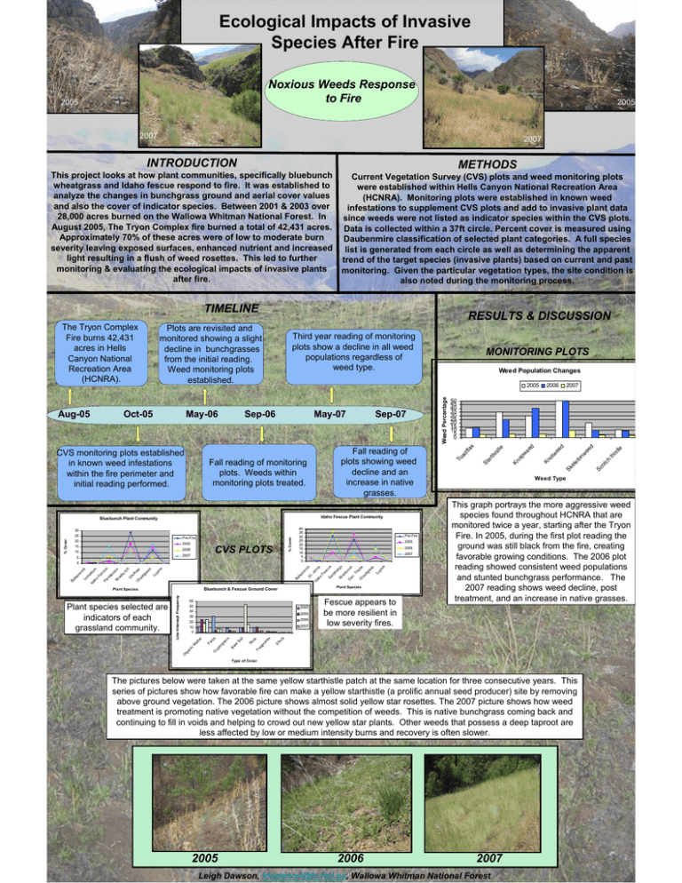
Ecological Impacts of Invasive Species After Fire Noxious Weeds Response to Fire 2005 2005 2007 2007 INTRODUCTION METHODS This project looks at how plant communities, specifically bluebunch wheatgrass and Idaho fescue respond to fire. It was established to analyze the changes in bunchgrass ground and aerial cover values and also the cover of indicator species. Between 2001 & 2003 over 28,000 acres burned on the Wallowa Whitman National Forest. In August 2005, The Tryon Complex fire burned a total of 42,431 acres. Approximately 70% of these acres were of low to moderate burn severity leaving exposed surfaces, enhanced nutrient and increased light resulting in a flush of weed rosettes. This led to further monitoring & evaluating the ecological impacts of invasive plants after fire. Current Vegetation Survey (CVS) plots and weed monitoring plots were established within Hells Canyon National Recreation Area (HCNRA). Monitoring plots were established in known weed infestations to supplement CVS plots and add to invasive plant data since weeds were not listed as indicator species within the CVS plots. Data is collected within a 37ft circle. Percent cover is measured using Daubenmire classification of selected plant categories. A full species list is generated from each circle as well as determining the apparent trend of the target species (invasive plants) based on current and past monitoring. Given the particular vegetation types, the site condition is also noted during the monitoring process. TIMELINE 2005 Idaho Fescue Plant Community Bluebunch Plant Community 2005 % Cover Pre-Fire CVS PLOTS 2006 Pre-Fire 2005 2006 2007 Ba lsa m ro ot Lo m at Id iu ah m o Fe sc ue P en st em on B lu eb un ch Sk ul lc ap Ch ea tg ra ss Lu pi ne Plant Species Bluebunch & Fescue Ground Cover 60 50 40 30 20 10 0 2000 2005 2006 en ts Fescue appears to be more resilient in low severity fires. 2007 tle th is This graph portrays the more aggressive weed species found throughout HCNRA that are monitored twice a year, starting after the Tryon Fire. In 2005, during the first plot reading the ground was still black from the fire, creating favorable growing conditions. The 2006 plot reading showed consistent weed populations and stunted bunchgrass performance. The 2007 reading shows weed decline, post treatment, and an increase in native grasses. The pictures below were taken at the same yellow starthistle patch at the same location for three consecutive years. This series of pictures show how favorable fire can make a yellow starthistle (a prolific annual seed producer) site by removing above ground vegetation. The 2006 picture shows almost solid yellow star rosettes. The 2007 picture shows how weed treatment is promoting native vegetation without the competition of weeds. This is native bunchgrass coming back and continuing to fill in voids and helping to crowd out new yellow star plants. Other weeds that possess a deep taproot are less affected by low or medium intensity burns and recovery is often slower. 2006 h Weed Type Type of Cover 2005 Sc ot c Sk el e to nw ee d 50 45 40 35 30 25 20 15 10 5 0 Sh ru b Ro ck Fr ag m s So il Ba re O rg an ic Cr yp to ga m at te r 2007 M Line Intercept Frequency Plant Species Fo rb s B 40 35 30 25 20 15 10 5 0 m ro ot St .J oh Id ns ah o Fe sc ue Sa nd be rg Bl s ue bu nc Ca h n. Th is tle Ch ea tg ra ss 2007 al sa % Cover 30 25 20 15 10 5 0 Plant species selected are indicators of each grassland community. Fall reading of plots showing weed decline and an increase in native grasses. 2006 Kn ot we ed Fall reading of monitoring plots. Weeds within monitoring plots treated. Sep-07 ee d May-07 le Sep-06 Kn ap w CVS monitoring plots established in known weed infestations within the fire perimeter and initial reading performed. Weed Population Changes St ar th ist May-06 MONITORING PLOTS Weed Percentage Oct-05 Third year reading of monitoring plots show a decline in all weed populations regardless of weed type. To ad fla x Aug-05 RESULTS & DISCUSSION Plots are revisited and monitored showing a slight decline in bunchgrasses from the initial reading. Weed monitoring plots established. Lu pi ne The Tryon Complex Fire burns 42,431 acres in Hells Canyon National Recreation Area (HCNRA). 2007 Leigh Dawson, lddawson@fs.fed.us, Wallowa Whitman National Forest
