weathered coal Use of sulfates
advertisement
weathered
coal
to identify
Useofsulfates
NM87801
Resources,
Socono,
NewMexico
Bureau
of Mines
andMineral
byFrankW.
Canpbeil,
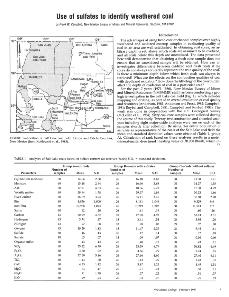
FIGURE 1-Location
of Salt Lake coal field, Catron and Cibola Counties,
New Mexico (from Kottlowski et al., 1985).
Introduction
The advantagesof using fresh core or channel samplesover highly
weathered and oxidized outcrop samples in evaluating quality of
coal in an area are well established. In obtaining coal cores, an arbitrary depth is set, above which coals are assumed to be oxidized,
and all coals below this depth are unoxidized. The data presented
here will demonstrate that obtaining a fresh core sample does not
ensure that an unoxidized sample will be obtained. How can an
investigator differentiate between oxidized and fresh coals if the
coresdo not always accuratelyrepresent the true quality of the coal?
Is there a minimum depth below which fresh coals can always be
retrieved?What are the effectson the combustion qualities oi coal
with depth and oxidation? How does the lithology of the overburden
affect the depth of oxidation of coal in a particular area?
For the past 7 years (1979-L986),New Mexico Bureau of Mines
and Mineral Resources(NMBMMR) staff has been conducting a geologic investigationin the Salt Lake coal field (Fig. 1), which includes
mapping and drilling, as part of an overall evaluationof coal quality
and resources(Anderson,1981;Andersonand Frost,1982;Campbell,
1981;Roybaland Campbell,1981;Campbelland Roybal, 1982).The
work was done in cooperation with the U.S. Geological Survey
(Mclellan et al., 1984).Sixty coal coresampleswere collectedduring
the course of this study. Twenty-two combustion and chemicalanalyses including eight major-oxide analyseswere run on each of the
samples shortly after collection. By using this entire population of
samplesas representative of the coals of the Salt Lake coal field the
mean and standard deviation values were obtained (Table 1, group
A). Calculationof rank basedon these analysesresults in a moist,
mineral-matter-free (mmf ) heating value of 10,988Btu/lb, which in-
TABLE 1-Analyses of Salt Lake coals based on sulfate content (as-receivedbasis); S D : standard deviatron.
Parameters
Equilibrium moisture
Moisture
Ash
Volatile matter
Fixed carbon
Btu
mmf Btu
Sulfur
Carbon
Hydrogen
Nitrogen
Oxygen
Sulfide
Sulfate
Organic sulfur
sio,
Fe,On
Al2o3
Tio,
CaO
Mgo
Na2O
KrO
Group A-aII coals
Number of
samples
Mean
60
60
60
60
60
60
60
60
43
+J
43
+J
60
18
60
60
60
60
60
60
60
60
60
14.66
15 48
77.97
29 94
36.69
8,856
10,988
.62
50.99
3.74
.97
10.29
.16
.03
.aJ
55.22
3.80
27.50
7.43
4.23
.63
.77
.29
s.D.
2.80
2.94
4.63
r.78
3.24
1,000
7,023
.20
4.82
.47
.08
183
l3
.07
.13
679
.92
5.46
.JU
1.42
.17
778
za
Group B-coals with sulfates
Number of
samples
Mean
S.D.
26
26
26
26
26
26
26
26
18
18
18
18
26
18
26
26
20
26
26
26
26
zo
26
1618
76.96
18.56
29.37
35.11
8,791,
70,249
.61.
47.98
3.41,
98
1,1.47
.72
09
40
53.59
3.66
27.66
7.43
3.87
.77
37
33
3.63
3.68
5 21.
1.86
3.76
7,049
7,302
.79
4.93
.54
.08
2.29
.74
.07
.13
6.79
.79
4.60
.29
1.25
.27
.22
.27
Group C-coals without sulfates
Number of
Mean
samples
S.D.
34
.l+
34
34
JA
JA
J+
34
24
z+
1A
24
JA
JA
J+
34
J+
J+
34
34
34
J+
J*
13.58
74.37
77.50
30.33
37.80
9,329
11,513
.60
53 13
3.98
.97
9.M
.77
0.00
.43
56.82
3.74
27.40
7.43
4.49
.58
51
.25
Nm Meico Geology February 1987
1.21,
1.55
4.29
7.66
2.90
646
372
.16
3.51
20
08
.6L
.10
0.00
.11
6.49
.75
6.ll
.31
1.51
.11
.37
.19
dicates a rank of subbituminous C for the coals in this area. In
calculatingresources,the U.S. GeologicalSurvey (Wood et al., 1983)
has specified that coal of this rank have a minimum thickness of 2.5
ft in order to be considereda resource.
Sulfateswere detected in many of the cores. In the Salt Lake coal
field samples, sulfate values near the surface are highest. Figure 2
shows the variation of sulfate-bearingcoals with depth; 1,6of the 26
sulfate-bearing coals sampled occurred within 60 ft of the surface.
Twenty coal samples were taken within 60 ft of the surface; 16 of
these have sulfates. Of the remaining 40 coal samples (deeper than
60 ft), nine demonstrated sulfate development (Fig. 2). Sulfate-bearing coals in this field occur to a maximum depth of 180 ft. One
exceptionalcase,however, showed 0.03%sulfateat 180ft. This core
was taken near the edge of a 150-ftmesa escarpment.Other deep
sulfate-bearingcoals are located below thick alluvium with less than
60 ft of undisturbed sedimentsoverlying the coal, or they are located
a short distance from outcropping coal. Those coals that are shallower than 60 ft and do not have any sulfates have a greater percentageof nonporous materials(claystonesand mudstones)acting
as an impermeable barrier.
Additional differencesare illustrated by dividing this group of data
into two separatepopulations,basedon the presenceor absenceof
sulfates.The samplesin group B (with sulfates)show notably poorer
values in combustion analysesthan those in group C (without sulfates;Table 1).
Proximate analyses
Comparing the profmate analysesof the two groups of data shows
the sulfate-bearing coals to be considerably degraded. The parameters that show no significant changeare the ash and volatile-matter
content. A t-test for the volatile-matter populations shows a significant difference between sulfate- and nonsulfate-bearing coals. The
absolute difference is 0.96Va,which is greater than ASTM (1983)
standardsfor repeatability (0.7Vo),but less than the 1.00% reproducibility limit for bituminous coals. Becausethis difference is detectablewithin a laboratory but not detectablebetween laboratories,
it is not considered significant for purposes of this paper.
The moisture content of the sulfate-bearing population is considerably higher than in the nonsulfate-bearing population. Figure 3
shows the change in moisture with depth, with a marked change in
the moisture content of the coals at 50-60 ft. Above 50 ft the mean
moisture content becomes significantly higher (seeTable 1, groups
B and C). The range of moisture content is much gteater for those
coals containing sulfates (72.06-23.417a)than for coals without sulfates(17.8/,-lL.09Vo).There are two anomalously high moisture values below 60 ft that are in sulfate-bearing coals. One coal is at a
depth of 180 ft, but the hole is located on top of a 150-ft mesa, 300
feet from the escarpment edge. Becausethe sample was downdip
from the escarpment, the effective cover thickness is only 30 ft. The
second sample was taken at a depth of 70 ft, with 40 ft of alluvium
to
X
?o
30
X
X
X
xp"
on
U
70
80
90
X
o
o
o
o
X
o^ox
E
OO
a\
v
x
o
o
X
n
h
60
E
X
XX
XOP
50
X
X
ool
40
X
X
O
EX
ilo
OO
r30
o^
TJ
r40
oR
r50
LJ
r60
o
oo5
0.ro
ol5
020
sulfofe(%)
FIGURE2-Dstribution of sulfate-bearing
coalswith depth.
0.25
O=Wifhout sulfotes
X =Withsulfoles
r80
9
ro il
t2 t3 t4 t5 t6 17 18 t9 202t
Moisture(o/")
222324
FIGURE3-Variation of moisturecontentwith dePthas relatedto sulfate
content.
February 7987 Netu Mexico Geology
"o
t70
O =Wifhout sulfoles
X =Wiihsulfoles
overlying it. In this case, the effective overburden thickness is only
30 ft.
The last parameter of the proximate analysis is fixed carbon. The
sulfate-bearing population has a mean value of 35.11 + -3.16To, while
the nonsulfate-bearing group has a mean of 37.80+-2.90%. This
difference remains significant, even when compared on a dry basis.
The depth at which the fixed carbon values undergo this change is
50-60 ft. The population that contains the sulfates also has a slightly
Iower range in fixed carbon values (40.12-29.8070) than does the
nonsulfate-bearing population (42.50-28.947"). A range of values are
expected because the fixed carbon is achieved by difference.
Heating value
The average as-received Btu values for those coals with sulfates
aresignificantly lower (8,191 Btu/lb) than those samples showing no
sulfates (9,329 Btullb). The difference of 1,138 Btu/lb between tfiese
two populations is considered significant. This may appear to be
due to the increase in the mean moisture content of 2.S9Vofor the
sulfate-bearing coals. The dry heating value for coals without sulfates averages 1,0,799Btu/lb; for coals with sulfates it is 9,772 Btu/lb,
-1.,027
resulting in a difference of
Btu/lb. There is approximately a
1,000-Btu/lb difference regardless of whether the coali are compaied
on an as-received or dry basis. Figure 4 shows the moist, mineralmatter-free heating values plotted against depth. At about 50 ft there
is a marked change in slope. The coals above 50 ft have a much
wider
lange in values and show a lower heating value. Nearly all
these shallow coals have sulfates. Coals deeperlhan 50 ft show a
very reduced range in both as-received and diy heating-mineral-matvalues. The
nonsulfate-bearing population has an average moist,
ter-free Btu of 11,513 Btu/lb, indicating a rank of high volatile C
bituminous for the Salt Lake coals. Thdsuffate-bearirig population
has an average moist, mineral-matter-free heating value of tZ,O+g
Btuilb, indicating an average rank of subbituminous C. The range
in moist, mineral-matter-free heating value is much narrower in t[e
nonsulfate-bearing coals (72,213-77,713 Btu/lb) than in the oxidized
sulfate-bearing coals (12,087-7,7 90 Btu/lb).
Ultimate analyses
The ultimate analyses also show differences depending on whether
or not sulfates are present. Both the carbon and hydrogen contents
of the coals are significantly reduced in those coals containing sulfates (see Table 1.,grgups B and C). These two elements are the irajor
contributors to the heating value of coals. Thus, a reduction in ihe
amount of these two elements, especially carbon, will result in a
reduction of the heating_value. Finally, oxygen affects the heating
value of,coal negatively. The oxygen conteniis greater in coals tha"t
have sulfates (7L477") than in those without sulfates 9.44%\. An
increase in the oxygen content_is accompanied by a lower heating
value of the coal. There is no change in the amount of nitrogen oi
sulfur present for either the sulfate- or nonsulfate-bearing coui-s.The
depth at which most of these parameters change is 50:60 ft. The
range in value increases dramatically for those coals within 50 ft of
the surface.
The total sulfur content remains constant between the two populations (Table 1, groups B and C). A difference occurs when the
sulfur forms are compared. No significant change occurs in the organic sulfur values- w_hen sulfate- and nonsulfate-bearing populations are compared. Sulfide sulfur is significantly reduced in the
sulfate-bearing coals. This indicates that only the sulfide sulfur is
being oxidized to sulfate, with both jarosite and gypsum occurring.
Effects on major elements
g]gnt majorelem,ents (SiO,, Al,O., Fe.Oo TiO,, CaO, MgO,
NarO,
_KrO) were analyzed using the high-temperature ash. The means and
standard deviations of these elements for all samples are given in
Table 1 (group A). Calcium and sodium values are both lowir when
sulfates are.present; neither calcium nor sodium is strongly associated with either the organic or mineral portion of the c6al. When
coals are subject to ofdation the organic bonds between calcium
and sodium aie broken, and they recimbi.re with the released sulfur
to form gypsum and thenardite. No thenardite was detected in the
coals, but this mineral, as well as some of the gypsum, might have
been removed from the coal by ground water. Potassium and magnesium values, however, show an increase with the development
of sulfate.
Resource evaluation
The variability of the oxidized (sulfate-bearing) coals is much greater
than that for nonsulfate-bearing coals. It is therefore easier to predict
coal quality parameters in the nonsulfate-bearing coals. The difference in rank determination based on the presence or absence of
oxidized coals could lead to significant discrepancies in coal-resource
figures. A population weighted in sulfate-bearing, essentially shallow (<60 ft) coals will show a rank of subbituminous B. According
to U.S. Geological Survey guidelines, coals of this rank have a minimum thickness for resource calculation of 2.5 ft. However, if drilling
extended well past the 50-ft depth, the coal rank would be high
volatile C bituminous. This rank coal has a minimum resource thickness of 1.2 ft; the difference could affect the measured resource of
an area by a minimum of .29 million tons per drill site. Using the
presence or absence of sulfates in the cores, one can calculate how
much of the resource in an area is oxidized and of Iower qualitv and
how many tons are present as fresh coal. Campbell ana Roybal (U82)
ro
20
xx
30
v
t
40
X^
50
nv
"ro
-o
60
Sx
70
x
80
n
rfV
-o
Y80
Ggo
a
3 too
X
X
ilo
t20
r30
t40
r50
r60
t70
O
X
=Withoutsulfotes
=Wiihsulfofes
t80+7,OOO
FIGURE 4-Variation
to sulfate content.
8,OOO
9,OOO |OOOO
reeBtu
Minerol-motter-f
of moist, mineral-matter-free
il,OOOt2000
coal with depth as related
Nm Mexico Geology February 7987
estimateda reservebase for the Salt Lake coal field of 347 million
tons within 250 ft of the surface. Using sulfates as a factor, this
reservebase can be recalculatedas approximately 69 million tons of
oxidized,lower rank coal and 278million tons of unoxidizedreserve
base.
Conclusions
The formation of sulfatesis due to an increasein the amount of
oxygen-richsurfacewater reachingthe coal.The oxygen then reacts
with the sulfides, pyrite, and marcasiteto form sulfates.Although
the maximum depth at which sulfate is found is 180ft, most of the
sulfatesare found within 50-60 ft of the surface.Coals containing
sulfatesthat are deeper than this 50-60-ft interval are overlain by
greateramounts of porous sandstonesor alluvium. In either case,
surfacemoisture,carrying oxygen,penetrateddeeperthan coalsnot
overlain by the same thicknessesof these porous lithologies. Converselv,severalcoalsthat have no sulfatedevelopment,vet are within
50-50'ft of the surface,are overlain by impermeablematerialssuch
as mudstone and claystone.In this case,the impermeablenature of
the overburden prevents oxygen-bearing water from reaching the
coal.The shallowestcoal in which no sulfatedevelopmentoccursis
40 ft.
and estimatingthe
When analyzingthe combustioncharacteristics
resourcesof a coal-bearingarea, attention should be paid to the
distribution of sulfatevaluesin the coals.Coalsin the Salt Lake coal
field within 40 ft of the surfacehave sulfates,high moisture, low
Btu, and increasedoxygen values. The range of values for those
parametersis much greater than for deeper coals.In the Salt Lake
coal field all coals within 40 ft of the surface can be considered
oxidized.None of thesefeaturesis desirablefor a steamcoal.These
data, if figured with the rest of the analyses,will tend to bias the
coal negatively. Likewise, excluding these data from an area-wide
appraisil would bias the results positively. Reporting both sets of
data and noting the maimum, minimum, and average depths of
oxidation will allow a better assessmentof area coals.
wish to thank Lynn Brandvold and William
ACKNOWLEDGMENTS-I
Stone for helpful comments and Orin Anderson, Louie Martinez,
and Ralph Wilcox for reviewing a version of this paper.
References
American Societyof Testing Materials, 1983,Gaseousfuels; ln Coal and coke: v 05 05,
D3175, pp. 402-405.
A n d e r s o nO
, . 1 . , 1 9 8 1 ,G e o l o g y a n d c o a l r e s o u r c e s o f C a n t a r a l o S p r i n g T t i z - m i n q u a d of Mines and Mineral Resources,Open-file Report 142,
rangle: New Mexico Bureau
'l:24,000.
pp.,2
maps, scale
73
Andei3on, O. 1., and Frost, S. J , 1982, Geology and coal resources of Twenty-Two
Spring quadrangle: New Mexico Bureau of Mines and Mineral Resources,Open-file
Report 143,6 pp., I map, scale1:24,000.
Camfbell, F. W., i981, Geology and coal resourcesof Ceno Prieto and The Dyke quadranqles:New Mexico Bureau of Mines and Mineral Resources,Open-file Report 1t14,
6S pp.,2 maps, scale1.:24,000.
Camf6ell, F. W., and Roybal, G. H., 1982, Geology and c-oalresources of the Fence
Lake 1:50,000quadrangle, Catron and Cibola Counties, New Mexico: New Mexico
Bureau of Mines and Mineral Resources,Open-file Report 207, 37 pp.' 2 maps.
Kottlowski, F. E., Campbell, F. W, Roybal, G. H., Hatton, K. S., 1985,New Mexico; in
1985Keystone coal industry manual: McGraw-Hill, Inc., pp. 531-540Mclellan,-M. W., Biewick, L. R., and Landis, E. R., 1984,StratigraPhicframework,
structure, and generalgeology o{ the Salt Lake coal field, Cibola and Catron Counties,
New Mexico: UlS. Geological'Suwey,MiscellaneousField StudiesMap MF-1589,scale
1.:24,000
in drilling data from
Roybal, G. H., and Campbell, F. W., 1981,Stratigraphic se-quence
Fence Lake area: New Mexico Bureau of Mines and Mineral Resources,Open-file
R e p o r t1 4 5 , 5 9p p . , l l m a p s ,s c a l e1 : 5 0 , 0 0 0 .
Wooi. G. H.. Kehn, T. M., Carter,M. D., and Culbertson,W C , 1983,Coal resource
classificationsystem of the U S Geological Survey: U S. GeologicalSurvey, Circular
8 9 1 .6 5 p p .
Continuedfrom page5
Ewing, T. E ,7978, Lead isotope data from mineral deposits of southern New Mexicea reinterPretation:
Economic Geology, v.73, pp 678-684
Gordon, C H., 1910, Magdalena district; in Lindgren,
W, Graton, L , and Gordon, C. H , The ore deposits
of New Mexico: U.S Geological Suruey, Professional
Paper68, pp 241.-250
Iovenetti, J , 1977, Hydrothermal silicificationof the Kelly
Limestone in the eastem portion of the Kelly mining
dishici, SoconoCounty,New Mexico:UnpublishedM.S
thesis, New Mexico Institute of Mining and Technology, Socono, 153pp
Kojima, S , and Sugaki,A ,7985, Phaserelationsin the
Cu-Fe-Zn-S system between 500 and 300'C under
hydrothermal conditions: EconomicGeology,v 80, pp
L58-777
Lasky, S G , 1932,The ore deposits of Socono County,
New Mexico:New Mexico Bureauof Mines and Mineral
Resources,BulJetin8, 139 pp
Loughlin, G. F, and Koschmann,A H,7942, Geology
and ore deposits of the Magdalena dishict, New Mexico: U S. GeologicalSuruey,ProfessionalPaper200,1,68
DP
Oibum, G R, and Chapin, C E.,7983, Ash-flow tuffs
and cauldronsin the northeastMogollon-Datil volcanic
field-a summary: New Mexico Geological Sociery,
Guidebook to 14th Field Conference, pp 197204
Park, D. E ,1971, Peuology of the Tertiary Anchor Canyon stock, MagdalenaMountains, central New Mexico:
Unpublished M S thesis,New Mexico Institute of Miningand Technology, Socono, 92 pp
Roedder,E , 1979,Fluid inclusions as samplesof ore fluid;
ln Barnes, H. L. (ed ), Geochemistry of hydrothermal
ore deposits, John Wiley and Sons, Znd ed,.,Pp. 6U737
Titley, S R., 1958,Silication as an ore control, Linchburg
mine, Socono County, New Mexico: Unpublished M.S
thesis, University of Arizona, Tucson, 153 pp.
Weber, R H , 1971,,K-Ar ages of Tertiary volcanic and
inhusive rocks in Socono, Catron, and Grant Counties,
New Meico: New Mexico Geological Society, Guidebook to 14th Field Conference, pp.220-223
n
February 1987
Nettt Mexico Geology
