Document 11032439
advertisement
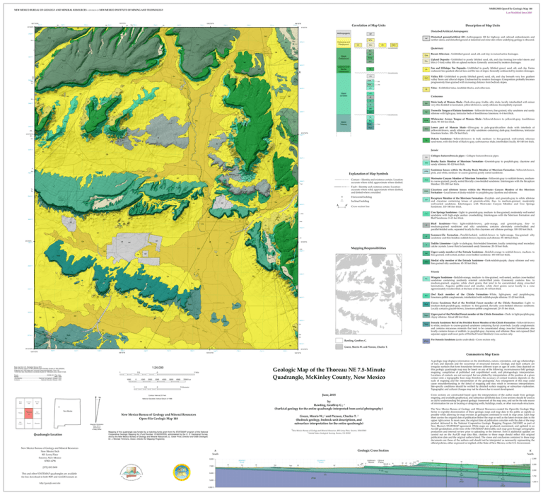
NMBGMR Open-File Geologic Map 148 NEW MEXICO BUREAU OF GEOLOGY AND MINERAL RESOURCES A DIVISION OF NEW MEXICO INSTITUTE OF MINING AND TECHNOLOGY 108°7'30"W 761000 35°30'0"N 762000 Qft E 763 000 Kml Qft Kd 108°5'0"W Qft 764000 E Qft Qsu 765000 Qft 766000 Last Modified June 2015 108°2'30"W 768000 767000 Qft 769000 E Qft 770000 108°0'0"W 772 000 771000 E Qft Qsu Qft Qft Kml Qvf daf u Qs Kd Qsu Km Kd Kml Qft Kd Kd Kml 3931000 Qt 2 Kml Qt Qt 3931000 Qt Qt Qt Qt Qvf Qt Jmw daf daf Jmw Jmw 3929000 Jmw b Jmw Jmb Jmb Jm b w Jm 3 Qt Qt Jm E Jmw Jmw Jmr Jmr Jcs Jcs Jmr Qt Jcs Jmr E Jcs Jb Qt Jmw Qt Jmr Qt Jcs Jcs Jcs Jmbs Jb Jb Jcs Jcs Qt Kmw Jb Jb Jmb Jmr Jmw Qt Kd Kml Jmbs Jmwc Jmw Qft Jmb Jmr Jmr Qft Jeu Jt Jt Jt Jeu Jm b Jt Jt Jeu Jcx Qt ^cpu Jt ^co ^cpu Qt ^cpu Qt daf Jem Jt ^w Qt Qt Qt Jt Qft Qft Qft Jem Qt Qvf daf Qt Qt 3924000 E daf Jt Jeu E QHa daf ^cpc 3 Jem daf 2 daf Qft Qt Jmb Qt Qt Kd Qsu Jmw Jmw r daf ^w ^cpu Qt Medial silty member of the Entrada Sandstone—Dark-reddish-purple, clayey siltstone and very fine-grained silty sandstone. 45–50 feet thick. Jmb Jm Qt Jem Kd Qt Kd Qt Jem Upper sandy member of the Entrada Sandstone—Reddish-orange to reddish-brown, medium- to fine-grained, well-sorted, aeolian cross-bedded sandstone. 130–150 feet thick. Jmb Qt 3922000 Bluff Sandstone—Very light-reddish-brown, pale-orange, and greenish-gray, fine- to medium-grained sandstone and silty sandstone; contains alternately cross-bedded and parallel-bedded units, separated locally by thin claystone and siltstone partings. 100–150 feet thick. Jeu 3923000 Jmbs Cow Springs Sandstone—Light- to greenish-gray, medium- to fine-grained, moderately well-sorted sandstone with high-angle aeolian crossbedding. Intertongues with the Morrison Formation and Bluff Sandstone. 0–65 feet thick. Todilto Limestone—Light- to dark-gray, thin-bedded limestone, locally containing small secondary calcite crystals. Lower third is laminated sandy limestone. 20–30 feet thick. Mapping Responsibilities Jmb Recapture Member of the Morrison Formation—Purplish- and greenish-gray to white siltstone and claystone containing lenses of greenish-white, fine- to medium-grained, moderately well-sorted sandstone. Intertongues with Westwater Canyon Member and Cow Springs Sandstone. 110–140 feet thick. Jt 35°25'0"N Jmw Qvf Jmw w Js Jm Jeu ^w E 3 Claystone and siltstone lenses within the Westwater Canyon Member of the Morrison Formation—Local lenses of dusky-reddish- to purplish-gray claystone and siltstone. Summerville Formation—Parallel-bedded, reddish-brown to light-orange, fine-grained silty sandstone and thin-bedded, reddish-brown claystone and siltstone. 95–140 feet thick. Kd Qt Js Westwater Canyon Member of Morrison Formation—Yellowish-gray to reddish-brown, mediumto coarse-grained, poorly sorted fluvially cross-bedded sandstone. Intertongues with the Recapture Member. 150–200 feet thick. Js Qt Jmb Jt Js Jt Qvf 4 Jmw Qsu Qt Jem ^w Qt Qvf Jb Qt Jem E Jcs Jmw daf daf Cross section line Jmb Qvf Qt 35°25'0"N 3923000 A' J Jmb Qt QHa Qft Jmr Inclined bedding Jmbs daf Qft Qt Qt Jmwc Jmw ^cpu Qt Jmb daf Jeu A 3925000 Kd Jeu ^w ^w ^w 6 Qvf 3 Sandstone lenses within the Brushy Basin Member of Morrison Formation—Yellowish-brown, pink, and white, medium- to coarse-grained, poorly sorted sandstone. Horizontal bedding Qt Qft Jt Jt Qft Jb daf Jt Qft Jt Qt ^w Jeu Jem Jt Jmb Js Js Jt ^w Jeu 3924000 Jt Jmw Qft Qsu Jem Qt Jeu Jeu Jeu ^co Jt Jmbs Jmw Fault—Identity and existence certain. Location: accurate where solid, approximate where dashed, and dotted where concealed Qt Jcx Jb Qvf Kd Qt Jcx Qft Jt Qt Qt Jmb Jcx Contact—Identity and existence certain. Location: accurate where solid, approximate where dashed. 3926000 Jt ^w Jt 4 u Jeu Je Qt Jt Qsu Qft su 4 3925 000 Jmr Q Jeu u Qs Explanation of Map Symbols Qt J Jmr Brushy Basin Member of Morrison Formation—Greenish-gray to purplish-gray, claystone and sandy siltstone. 80–120 feet thick. Jmr Jcs Js 3 Kml Jmw Jb Qft ^w Qt Jt Collapse features/breccia pipes—Collapse features/breccia pipes. Kd Jmr Qft Qft Dakota Sandstone—Yellowish-brown to buff, medium- to fine-grained, well-sorted, siliceous sand-stone, with thin beds of black to gray, carbonaceous shale, interbedded locally. 80–140 feet thick. Jmb Jmw Jb Jt Qft Qft Jmwc Jeu Jcx 3927000 Jmr Jmw Jt Lower part of Mancos Shale—Olive-gray to pale-grayish-yellow shale with interbeds of yellowish-brown, sandy siltstone and silty sandstone containing dark-gray, fossiliferous, lenticular limestone bodies. 100–150 feet thick. Jurasic Kd Qvf 35°27'30"N 3928000 Jmw Qt Jcs Kml Kml Jmb Jmwc Qt Whitewater Arroyo Tongue of Mancos Shale—Yellowish-brown to yellowish-gray, fossiliferous shale. 90–110 feet thick. Qt 3 Qft Kmw ^cpu Kmw Qft Jmwc Qt Jcs Twowells Tongue of Dakota Sandstone—Yellowish-brown, fine-grained, silty sandstone and sandy siltstone with light-gray, lenticular beds of fossiliferous limestone. 4–6 feet thick. Kmw Kml Jmb Jmwc Jmw Qt E Jmbs Jmwc Jb Qt 3926000 ^cpc ^cps Jmb Jmr Kdt Unconformity ^co Upper Triassic Km Kdt Qt E Qft Jcs 3927000 Kdt Jmr Jmb r Qt Jmr Qt Jmbs Jm Jcs Qt Jmw Jmw Kd Main body of Mancos Shale—Dark-olive-gray, friable, silty shale, locally interbedded with minor very thin-bedded to laminated, yellowish-brown, sandy siltstone. Incompletely exposed. ^w Jmb Qt Jmw Jem Jmw QHa Jmbs Jmb 3929000 Km Kd Km Jeu b Jmr Jmw Jmr Jmbs Jmb Jmb Qt Talus—Unlithified talus, landslide blocks, and colluvium. Cretaceous Jb Jt w Qt Qt Js Qft Jmb Kd Jmw 3 Qft Jmw Qt Jmw Jmbs Jmw Jmw Jmbs Jmb Valley Fill—Unlithified to poorly lithified gravel, sand, silt, and clay beneath very low gradient valley floors and alluvial slopes. Undissected by modern drainages. Composition probably becomes progressively finer-grained with increasing distance from bedrock slopes. Jcs Qt Qt Jm Upper Jurassic Qft Qft Jmbs Kd Jmw Jmw Qt Jmbs Kd Jmbs Qt Jmw Jmw Qt Unconformity Jmr 3930000 Km daf Kd Jmb Jmbs Kd Qvf Jmbs Jm Qt Fan and Hillslope Toe Deposits—Unlithified to poorly lithified gravel, sand, silt, and clay. Forms coalesced, low-gradient alluvial fans and the toes of slopes. Generally undissected by modern drainages. Jmwc Jmb Jmw Qt Qft Jmbs Qt Qft Qvf Km Km Qt Qt Kd Qft Qt Jmw Kd Km daf Upland Deposits—Unlithified to poorly lithified sand, silt, and clay forming low-relief sheets and thin (< 5 feet) valley fills on upland surfaces. Generally unincised by modern drainages. Jcx Qt Recent Alluvium—Unlithified gravel, sand, silt, and clay in incised active drainages. Qsu Qvf Jmw Qvf QHa Kml Km Qt Jmb Qt Qft Qt Jmbs Jmw Jmbs A' Qt Kml Kd 35°27'30"N Qt Qt 3930000 3928000 Qt J Qt Jmb Kd Lower(?) and Middle Cretaceous Kml Jmbs Quaternary Unconformity Kmw Kd 2 Qft 3 Qvf Kdt Upper Cretaceous Km Qt Qft Qsu Disturbed ground/artificial fill—Anthropogenic fill for highway and railroad embankments and earthen dams, and disturbed ground at industrial and mine sites where underlying geology is obscured. Km Km Qsu Qt Qft Kd Qft Kd Qt Qsu Qsu Qsu QHa Km Qsu 3 Holocene and Pleistocene 3932000 Km Qsu Kml Kd daf Kd Kd Kml Disturbed\Artificial\Antropogenic Anthropogenic Kd Description of Map Units Km Qsu Qft 3932000 Correlation of Map Units 35°30'0"N Qt Qt Jmw Triassic Qsu 3922000 Qft Qft Qt ^cpc Jmr ^cpu Qt 3 Qt ^cpc Qt Jmw Jmr u Qsu Jmr Qt ^cp ^co 3921000 Qt ^cpc Qvf Qt ^cpc ^cpu ^cpu ^cpc ^cpu ^cpc Qt ^cpc 3920000 ^cpu Qft Qt Qt ^cpc Qvf Qft ^cpu daf ^cpu 3920000 ^cpu daf ^cps Jm ^cpu Qt Qvf ^cpu Qvf Qvf 3919 000 Qsu Qft ^cpu daf ^cpu Qsu Qvf Qft 764000 Qft A E J 763000 765000 108°5'0"W 767000 766000 768000 Qft 108°2'30"W E 770000 769000 1 Roads...........................................................................©2006-2010 Tele Atlas Names.............................................................................................GNIS, 2008 Hydrography............................................National Hydrography Dataset, 2005 Contours........................................................National Elevation Dataset, 2000 0.5 1000 0 1 1000 0.5 2000 3000 4000 5000 0 6000 7000 Feet Prewitt Bluewater New Mexico New Mexico Bureau of Geology and Mineral Resources Open-File Geologic Map 148 Magnetic Declination May, 20114 9º 52' East At Map Center Quadrangle Location New Mexico Bureau of Geology and Mineral Resources New Mexico Tech 801 Leroy Place Socorro, New Mexico 87801-4796 [575] 835-5490 The New Mexico Bureau of Geology and Mineral Resources created the Open-file Geologic Map Series to expedite dissemination of these geologic maps and map data to the public as rapidly as possible while allowing for map revision as geologists continued to work in map areas. Each map sheet carries the original date of publication below the map as well as the latest revision date in the upper right corner. In most cases, the original date of publication coincides with the date of the map product delivered to the National Cooperative Geologic Mapping Program (NCGMP) as part of New Mexico’s STATEMAP agreement. While maps are produced, maintained, and updated in an ArcGIS geodatabase, at the time of the STATEMAP deliverable, each map goes through cartographic production and internal review prior to uploading to the Internet. Even if additional updates are carried out on the ArcGIS map data files, citations to these maps should reflect this original publication date and the original authors listed. The views and conclusions contained in these map documents are those of the authors and should not be interpreted as necessarily representing the official policies, either expressed or implied, of the State of New Mexico, or the U.S. Government. 1 New Mexico Bureau of Geology and Mineral Resources, 801 Leroy Place, Socorro, NM 87801 2 United States Geological Surevey, Reston, VA 20192 Mapping of this quadrangle was funded by a matching-funds grant from the STATEMAP program of the National Cooperative Geologic Mapping Act (Fund Number: G14AS00006), administered by the U. S. Geological Survey, and by the New Mexico Bureau of Geology and Mineral Resources, (L. Greer Price, Director and State Geologist, Dr. J. Michael Timmons, Assoc. Director for Mapping Programs). Geologic Cross Section A South 8,000 7,000 Mitchell Draw Qft Qvf Casamero Draw Qft ^cpc ^cpc Qft Qvf Jeu Qft Jem Jt Andrews Ranch Glover Claim Qft Js Qft Js ^w ^co ^cpu A' North Jb Qft Jmr Jmr Jmwc Jcs Jmb Kd Kd Jmb Jmw Jmr Jb Js Jt Jeu Jmw ^cps ^cpu 5,000 Kmw Kml Kd Jmb Jmw Jmr Jb Jem Jt ^w p^cps ^cps Jeu p^cps Km 2,250 2,000 1,750 1,500 m Js Jem ^cpu ^cps 4,000 ft Kdt ^co p^cps http://geoinfo.nmt.edu 2,500 Qft Qft ^w ^co 6,000 This and other STATEMAP quadrangles are available for free download in both PDF and ArcGIS formats at: Cross sections are constructed based upon the interpretations of the author made from geologic mapping, and available geophysical, and subsurface (drillhole) data. Cross sections should be used as an aid to understanding the general geologic framework of the map area, and not be the sole source of information for use in locating or designing wells, buildings, roads, or other man-made structures. Green, Morris W.; 2 and Pierson, Charles T. 2 (Bedrock geology, bedrock unit descriptions, and subsurface interpretation for the entire quadrangle) Pine Canyon Pass Goat Mountain Pre-Sonsela Sandstone (units undivided)—Cross section only. A geologic map displays information on the distribution, nature, orientation, and age relationships of rock and deposits and the occurrence of structural features. Geologic and fault contacts are irregular surfaces that form boundaries between different types or ages of units. Data depicted on this geologic quadrangle map may be based on any of the following: reconnaissance field geologic mapping, compilation of published and unpublished work, and photogeologic interpretation. Locations of contacts are not surveyed, but are plotted by interpretation of the position of a given contact onto a topographic base map; therefore, the accuracy of contact locations depends on the scale of mapping and the interpretation of the geologist(s). Any enlargement of this map could cause misunderstanding in the detail of mapping and may result in erroneous interpretations. Site-specific conditions should be verified by detailed surface mapping or subsurface exploration. Topographic and cultural changes may not be shown due to recent development. by Rawling, Geoffrey C.; 1 (Surficial geology for the entire quadrangle interpreted from aerial photography) Borrego Thoreau NE Sonsela Sandstone Bed of the Petrified Forest Member of the Chinle Formation—Yellowish-brown to white, medium- to coarse-grained sandstone containing fluvial cross-beds. Locally conglomeratic and contains micaceous minerals that tend to be concentrated along cross-bed laminations; also locally contains lenses of reddish- to purplish-gray claystone and siltstone. Base not exposed (bed separates upper and lower parts of Petrified Forest Member). Cross section only. Comments to Map Users June, 2015 Thoreau Upper part of the Petrified Forest member of the Chinle Formation—Dark- to light-purplish-gray, clayey siltstone. About 680 feet thick. 108°0'0"W 1 Kilometer National Geodetic Vertical Datum of 1988 Casamero Lake Correo Sandstone Bed of the Petrified Forest member of the Chinle Formation—Light- to medium-dark-purplish-gray, medium- to fine-grained, fluvially cross-bedded siliceous sandstone. Locally contains grayish-brown, limestone-pebble conglomerate. 20–35 feet thick. Green, Morris W. and Pierson, Charles T. 35°22'30"N Contour Interval 20 Feet Hosta Butte p^cps Geologic Map of the Thoreau NE 7.5-Minute Quadrangle, McKinley County, New Mexico 1 Mile 0 772000 771000 1:24,000 Base map from U.S. Geological Survey 2010. North American Datum of 1983 (NAD83) World Geodetic System of 1984 (WGS84). Projection and 1000-meter grid: Universal Transverse Mercator, Zone 12S 10 000-foot ticks: New Mexico Coordinate System of 1983(west zone), shown in blue. Rawling, Geoffrey C. Owl Rock member of the Chinle Formation—White, light-green, and purplish-gray, limestone-pebble conglomerate, interbedded with reddish-purple siltstone. 15–20 feet thick. 3919000 E 762000 108°7'30"W Jmr Qft Qsu E Qt Qft Qsu ^cpu 35°22'30"N Jmw ^cpu Wingate Sandstone—Reddish-orange, medium- to fine-grained, well-sorted, aeolian cross-bedded sandstone containing randomly oriented calcite-filled joints. Commonly contains fine- to medium-grained, angular, white chert grains that tend to be concentrated along cross-bed laminations. Angular, pebble-sized and smaller, white chert grains occur locally in a zone approximately 6 inches thick at the base of the unit. 35–45 feet thick. Qt Jmw Qsu Qt 3921000 Qt ^cpc ^cpu ^cpc Qt ^w ^cpc Jmw Jmr ^cpc Qsu ^cpu ^cpc Qt
