west-central New Mexico of Zuni
advertisement
of ZuniSandstore,
report
0nredefinition
Preliminary
NewMexico
west-central
by Orin l. Anderson,Geologist, New Mexico Bureau of Mines and Mineral Resources,Socorro, NM
Recent work by the New Mexico Bureau
of Mines and Mineral Resourceson the sequenceof Upper Jurassicrocks in the Zuni
Pueblo-Atarque area of west-central New
Mexico has resulted in a redefinition of the
Zuni Sandstone.Dutton (1885)originally described the Zuni as a series of sandstones
and sandy shaleslying between his Wingate
Sandstoneand his Cretaceoussection(present Dakota Sandstone)in the area around
the north and west sidesof the Zuni Plateau
(present Zuni uplift); he named this interval
the Zuni sandstones.Dutton did recognize
significant lateral variation in his new unit,
especiallybetween Zuni Pueblo and the Fort
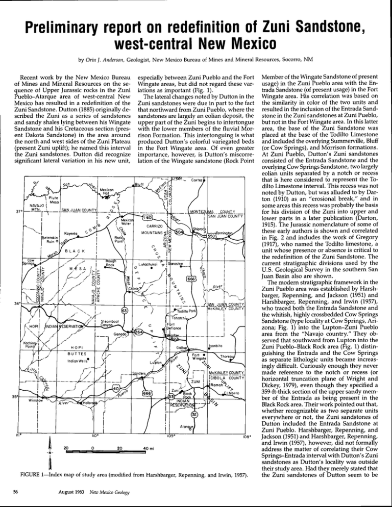
Wingate areas,but did not regard these variations as important (Fig. 1).
The lateral changesnoted by Dutton in the
Zuni sandstoneswere due in part to the fact
that northward from Zuni Pueblo, where the
sandstonesare largely an eolian deposit, the
upper part of the Zuni begins to intertongue
with the lower members of the fluvial Morrison Formation.This intertonguing is what
produced Dutton's colorful variegatedbeds
in the Fort Wingate area. Of even greater
importance,however, is Dutton's miscorreIation of the Wingate sandstone (Rock Point
: Meso
NAVAJO(
MTN. i
---TT---
___-qqqNtY__
'] JUANCOUNTY
I
lBelotokin
I
nuino
o<;
Nl
EI
vl
u.,{ s a t i
raia
L-"-,
,/
zi<
xto
;-il
)n--"'
/-i
I
I
i
i
i
i
River I
..M
\
t1
ZIL
>l<
'--):4'sreombool
Fori a
Wingole
?a
it
tl
zururI
FIGURE l-Index
map of study area (modified from Harshbarger, Repenning, and Irwin, 1957).
August 1983 New Mexico Geology
Member of the Wingate Sandstoneof Present
usage)in the Zuni Pueblo area with the Entrada Sandstone(of present usage)in the Fort
Wingate area. His correlation was based on
the similarity in color of the two units and
resulted in the inclusion of the Entrada Sandstonein the Zuni sandstonesat Zuni Pueblo,
but not in the Fort Wingate area.In this latter
area, the base of the Zuni Sandstonewas
placed at the base of the Todilto Limestone
and included the overlying Summerville,Bluff
(or Cow Springs),and Morrison formations.
At Zuni Pueblo, Dutton's Zuni sandstones
consisted of the Entrada Sandstone and the
overlying Cow SpringsSandstone,two largely
eolian units separatedby a notch or recess
that is here considered to represent the Todilto Limestone interval. This recesswas not
noted by Dutton, but was alluded to by Darton (1910)as an "erosional break," and in
someareasthis recesswas probably the basis
for his division of the Zuni into upper and
lower parts in a later publication (Darton,
1915).The Jurassicnomenclatureof some of
these early authors is shown and correlated
in Fig. 2 and includes the work of Gregory
(1917),who named the Todilto limestone, a
unit whose presenceor absenceis critical to
the redefinition of the Zuni Sandstone.The
current stratigraphic divisions used by the
U.S. GeologicalSurvey in the southern San
]uan Basin also are shown.
The modern stratigraphicframework in the
Zuni Pueblo area was establishedby Harshbarger, Repenning, and |ackson (1951)and
Harshbarger, Repenning, and Irwin (L957),
who tracedboth the EntradaSandstoneand
the whitish, highly crossbeddedCow Springs
Sandstone(type localityat Cow Springs,Arizona; Fig. 1) into the Lupton-Zuni Pueblo
area from the "Navaio countrv." Thev observed that southward from Luirton info the
Zuni Pueblo-Black Rock area (Fig. 1) distinguishing the Entrada and the Cow Springs
as separatelithologic units became increasingly difficult. Curiously enough they never
made reference to the notch or recess (or
horizontal truncation plane of Wright and
Dickey, t979), even though they specified a
359-ft-thicksection of the upper sandy member of the Entrada as being present in the
BlackRock area.Their work pointed out that,
whether recognizable as two separate units
everrrwhere or not, the Zuni sandstones of
Dutt'on included the Entrada Sandstone at
Zuni Pueblo. Harshbarger, Repenning, and
|ackson (1951)and Harshbarger, Repenning,
and Irwin (95n, however, did not formally
address the matter of correlating their Cow
SpringrEntrada interval with Dutton's Zuni
sandstonesas Dutton's locality was outside
their study area. Had they merely stated that
the Zuni sandstones of Dutton seem to be
D u t l o n .C . E .
D o r l o nN, . H .
r885
t 9t o
Z u n iP u e b l o R e c o n n o i s s o no
ce
f
N e wM e x i c o
n or i h w es t er n
N e wM e x i c o
Cr e l oc e o u s
Cr e t oc e o u s
All of the strata between the Wingate (now
Entrada) and Dakota sandstoneswere
mapped by Dutton (1885, Mt. Taylor and
the Zuni Plateau,U.S.G.S.6th Annl. Rept.
p. 737). The basal 2 to 25 feet above the
Wingate (now Entrada), where it was thin
bedded limestone, was called by Gregory
the Todilto formation and the overlying lower
part of the sandstoneunit was erroneously
calledNavajo by Gregory (7917,Geologyof
the Navajo country). The Todilto is not
present in the western and southern parts
of the Gallup-Zuni Basin. Baker,Dane, and
Reeside(1936)recognizedGregory's miscorrelation of Dutton's Zuni sandstonewith
the Navajo and correctly assigned the bulk
of the Zuni to their Morrison formation as
a sandstonefaciesof the formation (seeFigure 14, p. 51, ProfessionalPaper 183),but
they included the Todilto limestone as a
D o r t o n ,N .H .
t 9r 5
S o n t oF e
R o Ii r o o d
g u i de b o o k
G r e g o r yH, . E .
t 9t 7
Novojo
Country
C r e f oc e o u s
Cretoceous ()
Zuni
s on ds l on e
F.
o
'6
o
o
Zuni
sondslones
s h ol e
o
o
-) €
f
o
C o wS p r i n g s
S on d s t on e
N o vo j o
s o n ds f o n e
sondslone
I
T o di l t o l s .
l s ./
?tT o d i l f oL s .
:l
o
'-o
o
5
o
o
a
o
'i
f
(obsent)
D o k o t oS s .
c
o
o
o l oc
ol
cl a
o
ol !
al
( o b s e n)t
o
o
II
J
-)
( o b se n t)
UJ
upper
sondy
mb r .
E r u s n YE o s rn
Mhf
Weslwoler
C o n y o nM b r .
re
o le-cootu
Mbr.
Cor
o
.9
(obsent)
I
c)
Se
c
u n d i v i d e dI
o
equivolentsj o
!t
ol
c
.9
Cow
o
o
a
i
S
p
r
n
g
s
6
-=
o
=
Q)
;l
.9
o
o
q)
t)
C
Morrison
Formotion
McElmo
formolion
N
( o b se n t )
DokotoSs.
f
.E
F
o
()
r
o
o
o
o
c
o
o
J
DokotoSs.
USGS
C u r r e ndt i v i s i o n s
of soulhern
SoriJuonBosin
Ne w M e x i c o
G.
O
j
T h i sp o p e r
r983
ZuniPueblo
N e wM e x i c o
H o r s hb o r g e r ,
o .n d
Repenning
l r w i n1 9 5 7
Fort Wingote
s e c ti o n
E
o
o
member of the Morrison. The history is
rather fully documented on pp . 43-M of the
Baker,Dane, and Reesidereport. The comparable sandstone facies in the Black Mesa
irea of Arizona was later calledCow Springs
sandstoneby Harshbarger. Subsequentlyit
becameclear that the Baker, Dane, Reeside
reoort "Morrison sandstone facies" included equivalents of the upper part of the
San Rafaelgroup of which certainly the Todilto limestone, the Summerville, and the
Bluff sandstone (if that is now included in
the San Rafaelgroup, and I believe it is) are
representatives. Therefore, it is clear that
th-eonly proper procedure is to restore Zuni
sandstonein Dutton's original usage.If the
stratigraphic relationships had been fully
understood, it would have been highly appropriate for }{arshbarger to use Zuni for
what he termed Cow Springs sandstonein
the Black Mesa area. In my opinion, this
should have been done but there are, of
course, arguments in favor of a local Arizona name. Once it was done, however,
there was no good reasonwhy Cow Springs
March 8, 1956
TO: Geologic Names Committee
FROM: Carle H. Dane
SUBJECT: Reinstatement of Ztni
sandstone
composed of the undivided equivalents of
the Cow Springsand EntradaSandstonesin
this area, much of the later misunderstanding and misuse of the term Zuni Sandstone
would have been avoided. Such a statement
would have at once precludedthe use of the
name Zuni in those areas northward of the
Zuni Basin where the presenceof the Todilto
Limestone and the Summerville Formation
splits Dutton'sZuni sandstonesinto its component parts-the Entradaand Cow Springs
Sandstones.The term Zuni would have had
no application wherever the Todilto-Summerville units were recognizable.
No such clarification was forthcoming. In
1956,however, word reachedC. H. Dane of
the impending U.S. GeologicalSurvey publication by Harshbarger, Repenning, and Irwin in which the Cow Springs Sandstone
would be recognizedas far eastas Zuni-Black
Rock. Dane responded with the following
memorandum reprinted here with the -oermissionof the U.S. GeologicalSurvey:
f
N
a
ol
ol
9
El
cl
o
l
B l u ff S s .
fl
I le
o l Srmmerv,
(9l Formo t ion
TodilfoLs.
Enl rodo
S o n ds t o n e
oof
m e d i oI
silty
mDr.
(obsent)
(obseni)
o-
-:
(obsent)
o
()
'6
Wingote
s on ds t o n e
W i n g of e
sondstone
Wingote
s on ds i o n e
Wi n g o t e
sondslone o
o
o
o
@
.9
F
Iower
Triossic
.9
o
a
o
F
Leroux
f o r m oI i o n
o
o
o
o
'-
o
'6
red ond groy @
.9
shole
(,
c
o
c
o
c
o
o
c
g
F
Chinle
f o r m oI i o n
9
o
a
6
(,
o
o
o
o
r
F
C h in l e
F o r m oI i o n
W i n g ot e
() S on d s t o n e
Chinle
F o r m ot i o n
r
FIGURE 2-Evolution and correlation of Jurassicnomenclature used in the study area.
Nat: MexicoGeology August 1983
Chinle
F o rm o I i o n
Maxwell) as Morrison deposition came to a
intertonguing with the Recapture Member.
Green and Pierson (1977) used the terms close.A short distanceto the south of MaxCow Springs and Bluff in their San |uan Ba- well's areathe Brushy Basinmember has been
sin nomenclaturechart and statedthat where beveled off by pre-Dakota erosion of gently
the two are recognized separately, the con- northward-dipping strata and the Dakota
tact between them is consideredto be inter- Sandstonerests on the Zuni Sandstoneof
tonguing and arbitrary. Green (1975) had Maxwell (seealso Maxwell, 1982).
Mapping by Anderson (1982)in the Atarearlier discussedpaleodepositionalunits in
upperJurassicrocksof the southernSanJuan que area (Fig. 1) initially recognized the Cow
Basin and included the Bluff in his Cow Springs Sandstone, but this work had to be
Springs Sandstonewith an unconformity in revised with the realization that the Cow
the upper part. Lupe (1981)described the Springs Sandstonedid not include the lower
relationship of the lower part of the Morri- Entrada part of the section which is now conson to the Bluff and Cow Springs as a lateral sideredto be present in the area;the unit is
facies change; he considered the Recapture now recognized as the redefined Zuni SandShaleMember of the Morrison to have gone stone, describedbelow.
In view of the present confusion surroundfrom a fluvial to an eolian facies southward.
CarleH. Dane
Maxwell (1976), working in the area east ing the usage of the name Zuni and the obto map the un- vious need for a modern definition, the
The memorandum, which was never cir- of Grants, was the earliest
following publica- present author is recommending the followdefined
Zuni
Sandstone
culated, obviously did little to clarify the
map (Dane and ing: while it is recognized that the in-field
problem. Dane had earlier (ln Baker, Dane, tion of the state geologic
was
able to distin- distinction between the two largely eolian
Bachman,
1965).
Maxwell
and Reeside,1936)recommendedabandoncrossbedded units-the Entrada and the Cow Springs
guish
a
light-colored
eolian
ing the name Zuni, and now he was proBluff Sand- Sandstones-will be difficult and not always
sandstone
from
the
underlying
posing that Harshbarger's Cow Springs was
Pueblo practical, the name Zuni Sandstone shall be
in
half
the
Acoma
stone
the
northem
of
equivalentto Dutton's Zuni sandstones,when
quadrangle;
he
designated
this
upper
sand- applied to the undivided equivalents of the
in fact it was equivalent to only the upper
the
Bluff
to Entrada Sandstone and the Cow Springs
stone
the
Zuni.
He
considered
part of the Zuni. On the basis of this supSandstonewhere they rest in contact south
and
the
be
a
fluviatile
deposit
at
this
locality
posed equivalency, Dane recommended reof the Todilto-Summerville pinchouts in the
within
presence
numerous
pipes
of
sandstone
storing the name Zuni for use throughout
Zuni Basin and eastward as appropriate into
(of
it
helps
Zuni
Maxdistinguish
it
from
the
the Zuni, Acoma, and southem San Juan Bathe.A,comaBasin.This usagecorrespondsto
sinsand adjacentparts of Arizona regardless well); southward the Bluff and Zuni merge
the original use of the term Zuni in this area
into
the
Zuni
is
a
single
unit.
He
noted
that
of whether or not the Todilto or Summerville
only. Northward and eastward the Cow
Formationswere presentin the localsection. unconformably overlain by the Brushy Basin
Springs Sandstonerests on younger San RaMember
contact.
with
a
fossil
zone
at
the
soil
As per his memo, Dane did restore the
fael formations, the Summerville and the Bluff,
name Zuni for use in the Zuni-Acoma area Thus the Brushy Basindoesnot gradesouthand is more easily distinguished from them,
ward
into
at
this
locality,
as
eolian
sandstone
of New Mexico, but an official notification of
problems are found locally in recthe restorationwas not circulatedby the U.S. had been describedat other localities(Silver, although
ognizing the Bluff and Cow Springs as sep1948)
rather
part
of
and
therebut
has
cut
out
GeologicalSurvey. Official notification came
arate units. In the San Juan Basin and the
ostensiblythrough Keroher and others (1966) fore is younger than the underlying eolian
Acoma sag, the usage of the name Cow
is
sandstone.
This
interpretation
consistent
who updated the lexicon of geologic names.
continue in the
The lexicon, however, contained no defini- with the observation by most workers that Springs Sandstone ought to
Raup (7967),
Thaden,
Merrin,
and
sense
of
lower
Morrison
inonly
the
memberi
of
the
tion or redefinition of the Zuni Sandstone,
and Raup (1967), Green
nor did the New Mexico state geologic map tertongue with the eolian facies southward. Thaden, Santos,
(Dane and Bachman, 1965)contain any def- By Brushy Basintime, mostly shalewas being (L975),Green and Pierson Q9n), and Lupe
deposited and the sand supply for the eolian ( 1 e 8 1 ) .
inition or redefinition.
The type locality of the redefined Zuni
Subsequentto the publication of the state deposits to the south was interrupted. The
Mesa (Dowa Yageologic map and the lexicon (Keroher and Brushy Basin shale overlapped the Zuni (of Sandstone is Taaiyalone
others,1965),various investigatorsbeganrefening to the Zuni as the equivalent of one
of their mapped units. One of the earliest
such usages was by Thaden, Merrin, and
Raup (1962)and Thaden, Santos,and Raup
(1967)who mapped a 300-340-ft-thick finegrained crossbeddedsandstonebetween the
Summerville Formation and the Recapture
notch
Member of the Morrison Formation as the
yellow sandstonein the Thoreau, New Mexico, area. They stated that the yellow sandstone interval had been called Bluff or Zuni
by some workers and that it may be a tongue
of the Cow Springs Sandstone. Diagrammatically they indicated an intertonguing relationship between the Bluff and the yellow
sandstone,with a tongue of the Cow Springs
coming in from the west, and all units overlain by the RecaptureMember. The Bluff and
the yellow sandstone interval can be traced
all the way, with minor color changes,to the
Fort Wingate-Gallup area where Harshbar- FIGURE3-Type locality of Zuni Sandstoneat south end of TaaiyaloneMesa, Black Rock, New Mexico;
ger, Repenning, and Irwin (1957)described Twr, Rock Pbint Mem-berof Wingate Sandstone; !2, Zuni Sandstone; Kd, Dakota Sandstone. Note
the section as Cow Springs overlain by and medial color change and notch in Jz,
should have beenpermittedto jump east
of the Defianceuplif[t] into the ArizonaNew Mexicoborderarea;and thereis certainlyno justificationfor crowhoppingCow
Springsinto the AcomaBasinfarthereast.
(I might add that the thoughtof replacing
an elegantnamelike Zuni by the tawdry
commonplace
CowSpringscurdlesmy gizzard.ImaginetheEnchanted
Mesa,thefabulousEl Morro,"Acoma,theSkyCity", and
all the otherbeautifulrocksof the Land of
Enchantment
composed
of theCow Springs
sandstone.Heavenforbid!) On the New
MexicoGeologicMap,I proposeto useZuni
sandstonein the Gallup-Zuniand Acoma
basins.Theabandonment
of the namewas
basedon a misunderstandingof correlation. It shouldbe restored.
August 1983 New Mexico Geology
lanne on the Zuni Ttlz-minsheet)in sec. 36
T. 10 N., R. 19 W. and sec.1 T. 9 N., R. 19
W. (Fig. 3). Here the Zuni is estimatedat 500
ft in thickness with the notch or recessrepresenting the Todilto interval near the middle. A 2-4-inch-thick grayish-red (5 R 4/2)
very fine grained silty sandstone occupies
the notch, but there is little or no relief at
this horZon and little to distinguish the lower
and upper sandstones.Generally the lower
one is very light gray and slightly coarser
grained and better sorted than the upper,
although both are, for the most part, upper
very fine to lower fine grained. The upper
one is grayish pink (5 R 8/2) weathering to
pale red (5 R 5/2). Locally vertical grooves/
4-6 ft in height, are presentbelow the notch.
A more detailed account of the problems
in correlating |urassic rocks of west-central
New Mexico with those elsewhere on the
Colorado Plateauhas been prepared as New
Mexico Bureau of Mines and Mineral ResourcesOpen-file Report 774. lt includes a
regional correlation diagram and a measured
section at the proposed type locality of the
Zuni Sandstoneand is available through the
NMBMMR publications office, Socorro, NM,
87801.
ACKNowLEDGMENTS-The
writer wishes to
expresshis appreciation to Charles Maxwell,
StephenC. Hook, David W. Love, and Don
Wolberg for their helpful discussionand critical reading of the manuscript. Thanks also
are due the Pueblo of Zuni for kindly granting permissionto collectsamplesat and photograph the important outcrop localities.
References
Anderson, O. I., 1982,Geology and coal resourcesof the
Mesita de Yesoquadrangle, Cibola County, New Mexico: New Mexico Bureau of Mines and Mineral Resources,Open-file Report 171.
Baker,A. A., Dane, C. H., and Reeside,J.8., Jr., 1936,
Conelation of the JurassicFomations of parts of Utah,
Arizona, New Mexico, and Colorado: U.S. Geological
Suruey, ProfessionalPaper 183.
Dane, C. H., 1956, Reinstatement of Zuni Sandstone:
Memorandum to Geologic Names Committee of U.S.
GeologicalSuruey (unpublished).
Dane, C. H., and Bachman,G. O., 1955,Geologicmap
of New Mexico: U.S. GeologicalSurvey, scale1:500,000
of parts of northDarton, N. H-,1910, A reconnaissance
ern New Mexico and northernArizona: U.S. Geological
Survey, Bulletin 435.
-,
1915, Guidebook of the Westem United States,
part c. The Santa Fe Route: U.S. Geological Suruey,
Bulletin 61.3.
Dutton, C. E., 1885,Mount Taylor and the Zuni Plateau:
U.S. GeologicalSuruey, 5th Annual Report.
Gregory, H. 8., 1917, Geology of the Navajo country:
U.S. GeologicalSurvey, ProfessionalPaper 93.
Green, M. W., 1975, Paleodepositional units in Upper
Jurassic rocks in Galluplaguna area, New Mexico:
American Association of Petroleum Geologists, Bullet i n , 5 9 ,n o . 5 , p . 9 1 0 .
Green, M. W., and Pierson, C. T., 1977,A summary of
the shatigraphy and depositional environments of Jurassicand related rocks of the SanJuan Basin, Colorado
and New Mexico: New Mexico Geological Society,
Guidebook to 28th field conference,pp.747-752.
Harshbarger, J. W., Repenning, C. A., and Jackson, R.
L.,1957, JurassicstratiSraphy of the Navajo country:
New Mexico GeologicalSociety,Guidebook to 2nd field
conference,pp.95-99.
Harshbarger,J. W., Repenning, C. A., and Imin, J. H.,
1957, Stratigraphy of the uppermost Triassic and the
Jurassicrocks of the Navajo country: U.S. Geological
Suruey,ProfessionalPaper 291.
Keroher, G. C., and others, 1966, Lexicon of geologic
names for the United Statesfor 1936-1960:U.S. GeologicalSuruey,Bulletin 1200.
Lupe, R. D., 1981,,Sedimentologicrelation of the lower
part of the Monison Formation to underlying Jurassic
rocks, SanJuan Basin,New Mexico, in GeologicSuruey
researchin 1981:U.S. Geological Suruey, Professional
t'aoer
l2/5.
Maxwell,C.H.,1976, Geologicmap of theAcomaPueblo
quadrangle, Valencia County, New Mexico: U.S. Geological Suruey, Map GQ-1298.
-,
1982,Mesozoic shati8raphy of the Laguna-Crants
region: New Mexico Geological Society,Guidebook to
33rd field conference, pp. 261.-266.
Silver, Caswell, 1948, Jurassic overlap in western New
Mexico:American Associationof Peholeum Geologists,
Bulletin, v. 32, no. 1.
Thaden,R. E., Merrin, S., and Raup, O.8.,7967, Geologic map of the Grants SE quadrangle, Valencia County,
New Mexico: U.S. Geological Survey, Map GQ-682.
Thaden, R. E., Santos,E. S., and Raup, O. 8., 1967,
Geotogicmap ofthe Grants quadrangle, ValenciaCounty,
New Mexico: U.S. Geological Survey, Map CQ-581.
Wright, J. C., and Dickey,D. D.,1979, StratigraphicsecSanRafaelGroup and adiacentrocksin
tion of Turassic
ApacheCounty, Arizona: U.S. GbologicalSuruey,Openfile Report 79-246.
tr
USGS
TorocRapHrc MAps-NEw (scale 1:24,000)
yt
*Animas
77-82
*Animas Peak
77-82
*Animas Peak NE
77-82
*Antelope Pass
77-82
*BeaconHill
77-82
*Big Hatch Peak
77-82
*Black Point
77-82
*CarrizozoEast
75-82
*Cedarville
75-8L
*Center Peak
77-82
*Clanton Draw
77-82
*Doyle Peak
77-82
*Duoro
75-81.
*Fitzpatricks
77-82
*Foster Lake
75-82
*Cillespie Mountain
77-82
*Godfrey Peak
75-82
*Hachita Peak
77-82
*Hatchet Ranch
77-82
*Hilo Peak
77-82
*Horse Mountain
77-82
*Lake Lucero NE
75-82
*Lone Mountain
74-82
*Mescalero
75-82
*Mockingbird Gap SE
75-82
*Mount Baldy
77-82
*PiercePeak
77-82
*PlayasLake North
77-82
*PlayasLake South
77-82
*Red Canyon
75-82
*SanAntonio SE
75-82
*Sentinel Butte
77-82
*Sheridan Canyon
77-82
*Sierra Blanca Peak
75-82
*Tank Mountain
77-82
*TularosaNE
75-82
*U Bar Ridge
77-82
*Walnut Wells NE
77-82
*Whitemire Pass
77-82
*Wrye Peak
74-82
RsvIsEo ToPOGRAPHICMAps yr yr
(scale 1:24,000)
(rev)
62 79-82
"Acme
*Antelope Lookout
70 78-82
Mesa
*Candy Mesa
68 79-82
*Conejo Creek West
67 79-82
*Cooley Lake
67 79-82
*Cooper Ranch
66 79-82
*Deep Well
67 79-82
*Deering Place
67 79-82
*Dunlap Sill
67 79-82
+EighteenmileHill
67 79-82
*Eightmile Draw
62 79-82
*El Morro Mesa
66 79-82
*Elkins
67 79-82
*Fort Stanton
63 79-82
+Fort Sumner East
68 79-82
*Glenrio
68 81,-82
*Haystack Butte
67 79-82
*La Espia Peak
67 79-82
lat
37"52',30',
31"30',
37'37'30',
31"52'30',
37'52',30',
37'37',30',
37"22'30',
33'37'30',
34"1,5',
31'30',
31"30',
37'45'
34'22',30',
37'22',30',
32"37'30',
37"37'30',
33"22',30',
31"45',
37"37',30',
37"22',30',
31'30',
32"37',30',
33"45'
33'7',30',
33'30',
31"37',30',
31"22',30',
31"52',30"
31'45',
33"37',30',
33"45'
37"22'30',
31"30',
33"15',
37'45',
33"7'30',
31'30',
37"37',30',
31"45',
33"52',30',
long
108"45',
108'45',
108'45',
r08'52',3O',
108"37',30"
108"22',30',
r08"52',30',
105'45',
1,05"37'30',
708"37'30',
108'52',30',
108'15',
't04"52'30"
108"45',
106"7'30',
108"37',30',
105"52',30',
708"22',30',
108'15',
108"30',
108'30',
106"15',
105"45',
105"45',
106'15',
108"52',30',
108'15',
108"30',
108'30',
t06"7'30'
106'45',
t08"22',30',
108"15',
105'45',
108'45',
106'
t08"22',30',
108'30',
108"37',30',
105'15',
contour
(f0
10
40
20
40 20
20
10 40
10 40
20
10
40
20
20
10
40 10
10 50
40
40
40 20
40 20
20 10
20
10 50
20
40
40
40
40
10
10
205
105
40 20
40
80
20
10
10 40
10
40
20
lat
long
33"30',
35%5',
104"15',
708"7',30',
contour
(f0
105
20 10
34"30'
34"7',30',
34"
34"30'
33"37',30',
33"52',30',
33"52',30',
34"7'30',
33"37'30',
34"15'
33"37'30',
33"22',30',
34"22',30',
35"7',30',
33"45',
34'
104'
I04"22',30',
104"7',30',
104'30',
L04"45',
L04"1,5',
104'30',
104"7',30',
104'15',
704"37',30',
104"
105'30'
104"7'30"
103'
104"7',30',
104'15',
10
10
10
20
10
105
10
10
105
10
10
40 20
10
10
10
105
New Mexico Geology August 1983
